


Summary
The Southeastern United States, also referred to as the American Southeast, the Southeast, or the South, is a geographical region of the United States located in the eastern portion of the Southern United States and the southern portion of the Eastern United States. The region includes a core of states that reaches north to Maryland and West Virginia, bordering the Ohio River and Mason–Dixon line, and stretches west to Arkansas and Louisiana.[note 2]
Southeastern United States | |
|---|---|
Region | |
| American Southeast, the Southeast | |
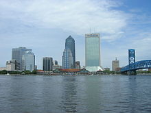
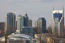
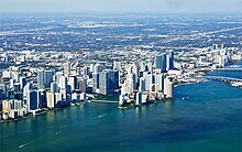
     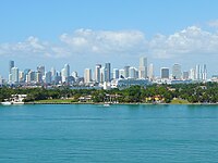 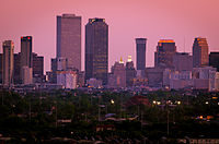 Images from top to bottom: Jacksonville, Charlotte, Nashville, Virginia Beach, Atlanta, Miami, and New Orleans | |
 A map of the United States with the Southeastern United States (in dark red) and states less frequently but sometimes considered part of the region (in light red) | |
| Largest cities | |
| States | |
| Largest metropolitan areas | |
| Area | |
| • Total | 580,835 sq mi (1,504,360 km2) |
| • Land | 540,511 sq mi (1,399,920 km2) |
| • Water | 40,324 sq mi (104,440 km2) 6.9% |
| Population (2018) | |
| • Total | 97,438,243 [note 1] |
| • Density | 150.5/sq mi (58.1/km2) |
| Time zone | EST (UTC-5)/CST (UTC-6); AST (UTC-4) in PR and VI |
| • Summer (DST) | EDT (UTC-4)/CDT (UTC-5); No DST in PR and VI |
There is no official U.S. government definition for the region, and it is defined variably among agencies and organizations.
History edit
The history of the present-day Southeastern United States dates to the dawn of civilization in approximately 11,000 BC or 13,000 BC. The earliest artifacts from the region were from the Clovis culture. Prior to the arrival of European colonialists, Native Americans occupied the region for several hundred years during the Woodland period.
The first Europeans to arrive in the region were conquistadors associated with the Spanish Empire. In 1541, Hernando de Soto journeyed through the southeast and crossed the Mississippi River. The region hosted the first permanent European settlement in North America, with the Kingdom of England establishing Jamestown, Virginia in 1607. Four southeast states, Georgia, North Carolina, South Carolina, and Virginia, were among the Thirteen Colonies who sent delegates to the Second Continental Congress in Philadelphia, which declared independence from the British Crown, which was established with the colonies' victory over the British in the American Revolutionary War.
During the American Civil War, the Confederate States of America consisted of the southeastern states of Florida, Alabama, Georgia, Mississippi, Tennessee, South Carolina, North Carolina, Virginia, Louisiana, and Arkansas. Texas was a Confederate State that isn't defined as part of the southeast region. Missouri and Kentucky had dual competing Unionist and Confederate state governments in the Confederate government of Missouri and Confederate government of Kentucky, Maryland and Delaware were neutral southern border states that remained with the Union. West Virginia split from Virginia during 1863, and also served as a border state that remained with the Union while being contested by the Confederacy and Confederate government of West Virginia. Following the Reconstruction era in the 1870s, many Southeast state legislatures passed Jim Crow laws. The American segregation era spanned from the late 19th century to the mid-1960s.
In the mid-to-late 20th century, the Southeast saw many shifting changes take place population wise and economically. The Southeast started to see a spur of new economic growth in the 1930s, which stemmed from New Deal policies such as the Tennessee Valley Authority and the Fair Labor Standards Act instituting a minimum wage for the entire nation. World War II further helped growth within the Southeast, as military bases and military production drew workers from farming or low-wage industries into a new economy. With farming mechanization picking up to speed in the 1940s, promotion of different industries, and federal spending on defense and space programs, the Southeast saw further economic transformation in the ensuing years and decades of the 20th century.[1]
The Southeast benefitted from its business and warm climate in its population growth during the late 20th century, as it helped in attracting job seekers and retirees from other U.S. regions. Florida in particular went from being the 27th most populated U.S. state in 1940 with 1.9 million residents, to being the 4th most populated U.S. state and having nearly 13 million residents in 2000. Southeast states such as North Carolina and Georgia saw large population growth increases as well during the late 20th century.[2]
Geography edit
The United States Geological Survey defines Southeastern United States as including the states of Alabama, Arkansas, Florida, Georgia, Kentucky, Louisiana, Mississippi, North Carolina, South Carolina, Tennessee, Puerto Rico, the United States Virgin Islands, and Virginia.
There is no official United States Census Bureau definition of the Southeastern United States. They instead divide a larger region which includes Texas, Oklahoma, Maryland, Delaware, Washington, D.C., and West Virginia, designated as "the South," into three separate subregions, none of which are conventionally considered to define the Southeast.
The nonprofit American Association of Geographers defines the Southeastern United States as including Alabama, Florida, Georgia, Kentucky, Maryland, Mississippi, North Carolina, South Carolina, Tennessee, Virginia, and West Virginia.[3] The OSBO (Organization Supporting Business Owners) uses the same states, but includes Arkansas and Louisiana. The states of Delaware and Missouri, along with the U.S. capital of Washington, D.C., are also sometimes added in definitions of the term.
Demographics edit
Most populous states edit
The most populous states in the region as of the 2020 United States census are: Florida (21,538,187), followed by Georgia (10,711,908), and North Carolina (10,439,388).[4]
| State | 2020 census | 2010 census | Change | Land area | Density |
|---|---|---|---|---|---|
| Alabama | 5,024,279 | 4,779,736 | +5.12% | 50,645 sq mi (131,171 km2) | 99.2/sq mi (38.3/km2) |
| Arkansas[a] | 3,011,524 | 2,915,918 | +3.28% | 52,035 sq mi (134,771 km2) | 57.9/sq mi (22.3/km2) |
| Florida | 21,538,187 | 18,801,310 | +14.56% | 53,625 sq mi (138,887 km2) | 401.6/sq mi (155.1/km2) |
| Georgia | 10,711,908 | 9,687,653 | +10.57% | 57,513 sq mi (148,959 km2) | 186.3/sq mi (71.9/km2) |
| Kentucky[a] | 4,505,836 | 4,339,367 | +3.84% | 39,486 sq mi (102,269 km2) | 114.1/sq mi (44.1/km2) |
| Louisiana[a] | 4,657,757 | 4,533,372 | +2.74% | 43,204 sq mi (111,898 km2) | 107.8/sq mi (41.6/km2) |
| Maryland[a] | 6,177,224 | 5,773,552 | +6.99% | 12,407 sq mi (32,134 km2) | 497.9/sq mi (192.2/km2) |
| Mississippi | 2,961,279 | 2,967,297 | −0.20% | 46,923 sq mi (121,531 km2) | 63.1/sq mi (24.4/km2) |
| North Carolina | 10,439,388 | 9,535,483 | +9.48% | 48,618 sq mi (125,920 km2) | 214.7/sq mi (82.9/km2) |
| South Carolina | 5,118,425 | 4,625,364 | +10.66% | 30,061 sq mi (77,857 km2) | 170.3/sq mi (65.7/km2) |
| Tennessee | 6,910,840 | 6,346,105 | +8.90% | 41,235 sq mi (106,798 km2) | 167.6/sq mi (64.7/km2) |
| Virginia[a] | 8,631,393 | 8,001,024 | +7.88% | 39,490 sq mi (102,279 km2) | 218.6/sq mi (84.4/km2) |
| West Virginia[a] | 1,793,716 | 1,852,994 | −3.20% | 24,038 sq mi (62,259 km2) | 74.6/sq mi (28.8/km2) |
| Total | 85,304,532 | 78,385,623 | +8.83% | 526,874 sq mi (1,364,597 km2) | 161.9/sq mi (62.5/km2) |
U.S. territories edit
Puerto Rico and the U.S. Virgin Islands are located southeast of Florida, and are considered to be in the South / Southeastern U.S. by the FAA, Agricultural Research Service, and the U.S. National Park Service.[5][6][7]
| Territory | 2020 census[8][9] | 2010 census | Change | Land area[10][9] | Density |
|---|---|---|---|---|---|
| Puerto Rico | 3,285,874 | 3,725,789 | −11.81% | 3,459 sq mi (8,959 km2) | 923.3/sq mi (356.5/km2) |
| U.S. Virgin Islands | 87,146 | 106,405 | −18.10% | 134 sq mi (346 km2) | 795.2/sq mi (307.0/km2) |
Largest cities edit


These are the largest cities in the Southeastern region of the United States by population, according to the United States Census Bureau in 2015:[11]
| Rank | City | State or territory |
Population (2020) |
|---|---|---|---|
| 1 | Jacksonville[a] | Florida | 949,611 |
| 2 | Charlotte | North Carolina | 874,579 |
| 3 | Washington | District of Columbia | 689,545 |
| 4 | Nashville[a] | Tennessee | 689,447 |
| 5 | Memphis | Tennessee | 633,104 |
| 6 | Louisville[a] | Kentucky | 633,045 |
| 7 | Baltimore | Maryland | 585,708 |
| 8 | Atlanta | Georgia | 463,878 |
| 9 | Virginia Beach | Virginia | 452,745 |
| 10 | Raleigh | North Carolina | 451,066 |
| 11 | Miami | Florida | 441,003 |
| 12 | New Orleans[a] | Louisiana | 389,617 |
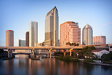
| 13 | Tampa | Florida | 384,959 |
| 14 | Lexington | Kentucky | 322,570 |
| 15 | San Juan | Puerto Rico | 318,441 |
| 16 | Orlando | Florida | 307,573 |
| 17 | Greensboro | North Carolina | 285,342 |
| 18 | Durham | North Carolina | 257,636 |
| 19 | Saint Petersburg | Florida | 257,083 |
| 20 | Norfolk | Virginia | 246,393 |
| 21 | Winston-Salem | North Carolina | 241,218 |
| 22 | Hialeah | Florida | 237,069 |
| 23 | Chesapeake | Virginia | 235,429 |
| 24 | Baton Rouge | Louisiana | 228,590 |
| 25 | Richmond | Virginia | 220,289 |
| 26 | Huntsville | Alabama | 215,006 |
| 27 | Fayetteville | North Carolina | 208,501 |
| 28 | Augusta[a] | Georgia | 206,922 |
| 29 | Little Rock | Arkansas | 202,591 |
- ^ a b c d e Jacksonville, Louisville, Nashville, Augusta and New Orleans are consolidated city-counties/parishes. Therefore the population given is for the entire city excluding other incorporated places lying within the county limits.
|- These are the metropolitan areas of the Southeastern region which exceed one million in population according to the United States Census Bureau's 2016 estimates:[12]
Combined statistical areas edit
Beyond Megalopolis by Virginia Tech's Metropolitan Institute, an attempt to update Jean Gottmann's work with current trends, defines two "megapolitan areas" contained within the Southeast, out of a total of ten such areas in the United States:
- "Piedmont" extending from North Carolina to Alabama
- "Peninsula" covering South Florida and Central Florida
Two others tie some areas on the margins of the Southeast to urban centers in other regions:
- "Gulf Coast" extending as far east as the western tip of Florida
- "Northeast" including much of Maryland, Central Virginia, and Eastern Virginia.
These are the combined statistical areas of the Southeastern region which exceed 1 million in population according to the United States Census Bureau's 2016 estimates. Note that the metropolitan areas of Tampa and Richmond are not included in any CSAs, so they are included in the table without constituent areas.[14]
Culture edit
The predominant culture of the Southeast U.S. has its origins with the settlement of the region by European colonists and African slaves during the 17th to 19th centuries, as large groups of English, Scottish, Scotch-Irish, Germans, Spanish, French, and Acadians migrated to the region. Since the late 20th century, the "New South" has emerged as the fastest-growing area of the United States economically. Multiculturalism has become more mainstream in the Southeastern states. African Americans remain a dominant demographic, at around 30% of the total population of the Southeast. The New South from a Southeastern standpoint, is largely built upon the metropolitan areas along the Interstate 85 (I-85) corridor. Cities along this corridor from north to south include Raleigh-Durham area, Greensboro, Charlotte, Spartanburg, Greenville, Atlanta, and Montgomery.
Climate edit
Most of the southeastern part of the United States is dominated by the humid subtropical climate (Cfa/Cwa). As one nears the southern portion of Florida, the climate gradually becomes tropical, as the winter season and all months have a mean temperature above 64.4 °F (18.0 °C) (the defined coldest monthly mean temperature of tropical climates).
Seasonally, summers are generally hot and humid throughout the entire region. The Bermuda High pumps hot and moist air mass from the tropical Atlantic Ocean and eastern Gulf of Mexico westward toward the southeast United States, creating the typical sultry tropical summers. Daytime highs are often in the upper 80s to lower 90s F.[15][16] Rainfall is summer concentrated along the Gulf Coast and the South Atlantic coast from Norfolk, Virginia southward, reaching a sharp summer monsoon-like pattern over peninsular Florida, with dry winters and wet summers. Sunshine is abundant across the southeastern United States in summer, as the rainfall often comes in quick, but intense downpours. The mid-South, especially Tennessee, and the northern halves of Mississippi, Alabama, and Georgia, have maximum monthly rainfall amounts in winter and spring, owing to copious Gulf moisture and clashes between warm, moist air from the Gulf of Mexico and cold, dry air from Canada during the cold season. In this area, December, March, or April are typically the wettest months; August to October, the driest months (for example, in Tupelo, MS, Huntsville, AL and Memphis, TN).
Winters are cool in the northern areas like Tennessee, Virginia, Maryland, and western North Carolina, with average high temperatures in the 45 °F (7 °C) range in January. Farther south, winters become milder across interior eastern North and South Carolina, Georgia, and Alabama, with average January highs in the 53 °F (12 °C) range. As one nears the Gulf of Mexico, coastal plain, and coastal areas of Georgia and the Carolinas, winters become warm, with daytime highs near or over 60 °F (16 °C). Once in Florida, daytime highs are above 70 °F (21 °C) from just south of St. Augustine on the Atlantic coast and Clearwater on the Gulf Of Mexico. Extreme southern Florida has the warmest winter temperatures (mid 70's F) in the United States. Winters tend to be very dry and sunny across Florida, with a gradual increase in winter rainfall with increasing latitude, especially west of the Appalachian Mountains.
Economy edit
The Southeast economically has changed dramatically since the late 20th century. There has been a boom in its service economy, manufacturing base, high technology industries, and the financial sector. Examples of this include the surge in tourism in Florida and along the Gulf Coast; the numerous new automobile production plants such as Mercedes-Benz in Tuscaloosa;[17] Hyundai in Montgomery;[18] Toyota Motors in Blue Springs, Mississippi;[19] Kia in West Point, Georgia; BMW production plant in Greer, South Carolina; Volkswagen in Chattanooga; GM manufacturing plant in Spring Hill, Tennessee; with the Nissan North American headquarters in Franklin, Tennessee; Mercedes-Benz USA; and Porsche North American headquarters in the Atlanta area; the two largest research parks in the country: Research Triangle Park in the Triangle area of North Carolina (the world's largest) and the Cummings Research Park in Huntsville, Alabama (the world's fourth largest); corporate headquarters of Bank of America, Truist Financial, and Wells Fargo in Charlotte, North Carolina, the corporate headquarters of Verso Paper and FedEx in Memphis, Tennessee as well as the corporate headquarters of the Coca Cola Company, Delta Airlines, the Home Depot and United Parcel Service in Atlanta, Georgia. Dillards, along with Heifer International, is headquartered in Little Rock, Arkansas. Walmart is also headquartered in Arkansas.
In 2020, Fortune 500 companies having headquarters in the Southeast region include: 22 in Virginia, 18 in Georgia, 18 in Florida, 13 in North Carolina, and 10 in Tennessee.[20] This economic expansion has enabled parts of the South to have some of the lowest unemployment rates in the United States.[21] In Alabama, there is the large-scale manufacturing project owned by the German steel megacorporation ThyssenKrupp, which operates a massive, state-of-the-art facility in Mobile.
Even with certain states and areas in the Southeast doing well economically, many Southeast states and areas still have a high poverty rate when compared to the U.S. nationally. In 2017, seven Southeast states were in the top ten nationwide when it came to having the highest poverty rate.[22]
Research and development areas edit
Research Triangle Park in the Raleigh–Durham urban area of North Carolina, has emerged as a major hub of technology, governmental, and biotechnological research and development. The Cummings Research Park in the Huntsville, Alabama area, is the second-largest research complex in the nation. Located in Huntsville is the Redstone Arsenal, United States Army Missile Command, the U.S. Space & Rocket Center, NASA's Marshall Space Flight Center and other key government, military, and aerospace agencies. Tullahoma, TN contains the Arnold Air Force Base. The base is home to the Arnold Engineering Development Complex (AEDC), the most advanced and largest complex of flight simulation test facilities in the world.
The National High Magnetic Field Laboratory in Tallahassee, Florida, is the largest laboratory in the world devoted to the study of magnetism.[23] The University of South Carolina is currently constructing a research campus in downtown Columbia, and the university is the nation's only National Science Foundation-funded Industry/University Cooperative Research Center for Fuel Cells.[24]
Education edit
Higher education edit


The region includes a number of notable universities, public and private, whose research exert influence globally. Chief among public universities are:
- Auburn University[25]
- Clemson University[26]
- College of William & Mary[27]
- Florida State University[28]
- Georgia Institute of Technology[29]
- George Mason University[30]
- Louisiana State University[31]
- Mississippi State University[32]
- North Carolina State University[33]
- University of Alabama[34]
- University of Arkansas[35]
- University of Florida[36]
- University of Georgia[37]
- University of Kentucky[38]
- University of Louisville[39]
- University of Maryland[40]
- University of Memphis[41]
- University of Mississippi[42]
- University of North Carolina at Chapel Hill[43]
- University of South Carolina[44]
- University of South Florida[45]
- University of Tennessee[46]
- University of Virginia[47]
- University of West Virginia[48]
- Virginia Polytechnic Institute and State University[49]
There are a number of well-known private institutions, as well. Notable among these are:
- American University[50]
- Belmont University[51]
- Catholic University of America
- Centre College
- Davidson College
- Duke University[52]
- Emory University
- Fisk University
- Furman University
- Georgetown University
- George Washington University
- Howard University
- Johns Hopkins University
- Liberty University
- Mercer University
- Morehouse College
- Rhodes College
- Samford University
- Spelman College
- Tulane University
- Tuskegee University
- University of Miami
- University of Richmond
- Vanderbilt University
- Wake Forest University
- Washington and Lee University
The region is home to the greatest number of historically black colleges and universities in the nation. The three largest in the region are:
Sports edit
Professional edit


Although American football is prevalent across the United States, it is especially pervasive in the Southeast. There are nine National Football League (NFL) franchises across the region: Atlanta Falcons, Baltimore Ravens, Carolina Panthers, Jacksonville Jaguars, Miami Dolphins, New Orleans Saints, Tampa Bay Buccaneers, Tennessee Titans, and Washington Commanders. The NFL maintains a stronger commercial presence than any other major North American professional sports league.
The Southeast has seven National Basketball Association (NBA) franchises: Atlanta Hawks, Charlotte Hornets, Memphis Grizzlies, Miami Heat, New Orleans Pelicans, Orlando Magic, and Washington Wizards.
Major League Baseball (MLB) maintains five teams in the Southeast: Atlanta Braves, Baltimore Orioles, Miami Marlins, Tampa Bay Rays, and Washington Nationals.
The Southeast has five National Hockey League (NHL) franchises: Carolina Hurricanes, Florida Panthers, Nashville Predators, Tampa Bay Lightning, and Washington Capitals.
Major League Soccer currently holds six clubs: Atlanta United FC, Charlotte FC, DC United, Inter Miami CF, Nashville SC and Orlando City SC.
The majority of NASCAR teams are headquartered in the Charlotte area along with the sports operations headquarters and media outlets. Tracks in the region include Atlanta Motor Speedway,[53]Bristol Motor Speedway,[54]Charlotte Motor Speedway,[55]Darlington Raceway, Daytona International Speedway, Homestead-Miami Speedway, Martinsville Speedway, Nashville Superspeedway, North Wilkesboro Speedway, Richmond Raceway, and Talladega Superspeedway.
The southeast also hosts two of the three legs of the American Triple Crown: the Kentucky Derby in Louisville, and the Preakness Stakes in Baltimore. The Derby is considered the western leg of the crown and the Preakness is traditionally considered the southern leg.
College edit
The Atlantic Coast Conference is an NCAA Division I conference with many Southeastern college teams, including the: Clemson Tigers, Duke Blue Devils, Florida State Seminoles, Georgia Tech Yellow Jackets, Louisville Cardinals, Miami Hurricanes, North Carolina Tar Heels, NC State Wolfpack, Virginia Cavaliers, Virginia Tech Hokies, and Wake Forest Demon Deacons.[56]
The Southeastern Conference is also an NCAA Division I conference made up of Southeastern college teams, including the: Alabama Crimson Tide, Arkansas Razorbacks, Auburn Tigers, Florida Gators, Georgia Bulldogs, Kentucky Wildcats, LSU Tigers, Ole Miss Rebels, Mississippi State Bulldogs, South Carolina Gamecocks, Tennessee Volunteers, and Vanderbilt Commodores.[57]
The Sugar Bowl, Orange Bowl, Peach Bowl, and Citrus Bowl are notable college football bowls held in Southeastern cities.[58][59][60][61][62][63][64][65][66][67][68][69][70]
See also edit
- Appalachia
- Black Belt in the American South
- Deep South
- Hammock (ecology) – Southeastern habitat
- Indigenous peoples of the Southeastern Woodlands
- Southeastern conifer forests – Southeastern habitat
- Southeastern mixed forests – Southeastern habitat
- Upland South
References edit
- ^ McDonald, F. John. (2013). Urban Areas in the Transformation of the South: A Review of Modern History – Hindawi. Urban Studies Research. Retrieved April 3, 2022.
- ^ Historical Population Change Data (1910–2020). census.gov. Retrieved April 3, 2022.
- ^ Southeastern Division of the Association of American Geographers
- ^ "Annual Estimates of the Resident Population: April 1, 2010 to July 1, 2016 (PEPANNRES): All States within the United States and Puerto Rico". American Factfinder. U.S. Census Bureau. Archived from the original on February 13, 2020. Retrieved May 2, 2017.
- ^ https://www.faa.gov/about/office_org/headquarters_offices/arc/southern_region/ Federal Aviation Administration. Southern Region. Retrieved July 5, 2020.
- ^ "Southeast Area : USDA ARS". www.ars.usda.gov. Retrieved March 8, 2024.
- ^ "Contact Us - Rivers, Trails, and Conservation Assistance Program (U.S. National Park Service)". web.archive.org. July 5, 2019. Retrieved March 8, 2024.
- ^ "U.S. Census Bureau QuickFacts: Puerto Rico". www.census.gov. Retrieved March 8, 2024.
- ^ a b The World Factbook CIA World Factbook. U.S. Virgin Islands. Retrieved July 5, 2020.
- ^ The World Factbook CIA World Factbook. Puerto Rico. Retrieved July 5, 2020.
- ^ "Annual Estimates of the Resident Population for Incorporated Places of 50,000 or More, Ranked by July 1, 2015 Population: April 1, 2010 to July 1, 2015 – United States – Places of 50,000+ Population (PEPANNRSIP)". American Factfinder. United States Census Bureau, Population Division. Archived from the original on February 13, 2020. Retrieved May 2, 2017.
- ^ "Annual Estimates of the Resident Population: April 1, 2010, to July 1, 2016 (PEPANNRES): All Metropolitan and Micropolitan Statistical Areas within the United States and Puerto Rico". American Factfinder. U.S. Census Bureau. Archived from the original on February 13, 2020. Retrieved May 2, 2017.
- ^ https://datausa.io/profile/geo/san-juan-caguas-guaynabo-pr-metro-area/ Datausa.io. San Juan-Caguas-Guaynabo metropolitan area. Retrieved July 5, 2020.
- ^ "Annual Estimates of the Resident Population: April 1, 2010 to July 1, 2016 (PEPANNRES)". American Factfinder. United States Census Bureau. Archived from the original on February 13, 2020. Retrieved May 2, 2017.
- ^ "Miami, Florida Temperature Averages". Weatherbase. Retrieved December 29, 2015.
- ^ "Virginia Beach, Virginia Temperature Averages". Weatherbase. Retrieved December 29, 2015.
- ^ "Mercedes-Benz of Tuscaloosa". Mercedes-Benz. Retrieved July 22, 2023.
- ^ "Hyundai Motor Manufacturing Alabama LLC". hmmausa.com. Retrieved July 22, 2023.
- ^ "Toyota Motor Manufacturing, Mississippi, inc (TMMMS)". Toyota. Retrieved July 22, 2023.
- ^ Number of U.S. companies listed in the Fortune 500 ranking in 2020, by state | Statista. Retrieved February 13, 2021.
- ^ "State jobless rate below US average". The Decatur Daily. August 19, 2005. Archived from the original on September 28, 2007. Retrieved February 12, 2007.
- ^ Moore, Roger. (2018). Poverty Statistics for Southern States. slcatlanta.org. Retrieved February 13, 2021.
- ^ Everett, Lauren. (October 7, 2018). The National High Magnetic Field Laboratory. Lab Manager. Retrieved February 13, 2021.
- ^ "Business Partnership Opportunities". Innovista.sc.edu. Archived from the original on March 17, 2012. Retrieved December 13, 2013.
- ^ "Auburn University Homepage". Auburn.edu. Retrieved July 22, 2023.
- ^ "Clemson University Homepage". Clemson.edu. Retrieved July 22, 2023.
- ^ "William & Mary Homepage". wm.edu. Retrieved July 22, 2023.
- ^ "Florida State University Homepage". FSU.edu. Retrieved July 22, 2023.
- ^ "Georgia Tech Homepage". gatech.edu. Retrieved July 22, 2023.
- ^ "George Mason University Homepage". gmu.edu. Retrieved July 22, 2023.
- ^ "Welcome to LSU, a top research university". LSU.edu. Retrieved July 22, 2023.
- ^ "Mississippi State University Homepage". msstate.edu. Retrieved July 22, 2023.
- ^ "NC State University Homepage". NCSU.edu. Retrieved July 22, 2023.
- ^ "The University of Alabama Homepage". UA.edu. Retrieved July 22, 2023.
- ^ "University of Arkansas Homepage". uark.edu. Retrieved July 22, 2023.
- ^ "University of Florida Homepage". ufl.edu. Retrieved July 22, 2023.
- ^ "History & Traditions – University of Georgia". UGA.edu. Retrieved July 22, 2023.
- ^ "University of Kentucky Homepage". UKY.edu. Retrieved July 22, 2023.
- ^ "University of Louisville Homepage". Louisville.edu. Retrieved July 22, 2023.
- ^ "The University of Maryland Homepage". UMD.edu. Retrieved July 22, 2023.
- ^ "The University of Memphis Homepage". Memphis.edu. Retrieved July 22, 2023.
- ^ "Ole Miss University Homepage". olemiss.edu. Retrieved July 22, 2023.
- ^ "The University of North Carolina at Chapel Hill". UNC.edu. University of North Carolina at Chapel Hill. Retrieved July 22, 2023.
- ^ "University of South Carolina Homepage". SC.edu. Retrieved July 23, 2023.
- ^ "University of South Florida Homepage". USF.edu. Retrieved July 23, 2023.
- ^ "University of Tennessee, Knoxville Homepage". UTK.edu. Retrieved July 23, 2023.
- ^ "The University of Virginia Homepage". Virginia.edu. Retrieved July 23, 2023.
- ^ "West Virginia University Homepage". WVU.edu. Retrieved July 23, 2023.
- ^ "Virginia Tech Homepage". VT.edu. Retrieved July 23, 2023.
- ^ "American University Homepage". American.edu. Retrieved July 23, 2023.
- ^ "Belmont University Homepage". Belmont.edu. Retrieved July 23, 2023.
- ^ "Duke University Homepage". Duke.edu. Duke University. Retrieved November 13, 2023.
- ^ "Atlanta Motor Speedway website". Atlantamotorspeedway.com. Retrieved July 23, 2023.
- ^ "Bristol Motor Speedway website". Bristolmotorspeedway.com. Retrieved July 23, 2023.
- ^ "Charlotte Motor Speedway website". Charlottemotorspeedway.com. Retrieved July 23, 2023.
- ^ "The Official website of the Atlantic Coast Conference". TheACC.com. Atlantic Coast Conference. Retrieved July 6, 2023.
- ^ "The Official website of the Southeastern Conference". secsports.com. Retrieved July 6, 2023.
- ^ "Florida Sports Teams". Wright Realtors.com. Retrieved March 26, 2020.
- ^ "North Carolina Sports Teams". Wright Realtors.com. Retrieved March 26, 2020.
- ^ "Georgia Sports Teams". Wright Realtors.com. Retrieved March 26, 2020.
- ^ "Louisiana Sports Teams". Wright Realtors.com. Retrieved March 26, 2020.
- ^ "Tennessee Sports Teams". Wright Realtors.com. Retrieved March 26, 2020.
- ^ "Mississippi Sports Teams". Wright Realtors.com. Retrieved March 26, 2020.
- ^ "Alabama Sports Teams". Wright Realtors.com. Retrieved March 26, 2020.
- ^ "South Carolina Sports Teams". Wright Realtors.com. Retrieved March 26, 2020.
- ^ "Kentucky Sports Teams". Wright Realtors.com. Retrieved March 26, 2020.
- ^ "Virginia Sports Teams". Wright Realtors.com. Retrieved March 26, 2020.
- ^ "Maryland Sports Teams". Wright Realtors.com. Retrieved March 26, 2020.
- ^ "Washington DC Sports Teams". www.wrightrealtors.com. Retrieved March 26, 2020.
- ^ "West Virginia Sports Teams". Wright Realtors.com. Retrieved March 26, 2020.
Notes edit
- ^ Excludes Puerto Rico and the U.S. Virgin Islands
- ^ This includes Florida, Georgia, South Carolina, North Carolina, Virginia, Missouri, West Virginia, Maryland, Delaware, Washington, D.C., Kentucky, Tennessee, Mississippi, Alabama, Louisiana, and Arkansas.
External links edit
- Flora Atlas of the Southeastern United States – by the North Carolina Botanical Garden & University of North Carolina Herbarium (NCU).
- Sea Level Changes in the Southeastern United States. Past, Present, and Future – University of South Florida (August 2011)
- Britannica Southeast U.S. – video on YouTube
34°N 85°W / 34°N 85°W