


Summary
Tayibe, Et Tayibe or Et Taibeh is a village in the Marjeyoun District in south Lebanon.
Tayibe
طيبة الطيبة (مرجعيون) | |
|---|---|
Village | |
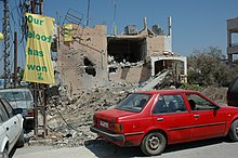
 Posters on Tayibe village walls after the 2006 Lebanon War | |
 Tayibe Location within Lebanon | |
| Coordinates: 33°16′35″N 35°31′14″E / 33.27639°N 35.52056°E | |
| Grid position | 198/297 PAL |
| Country | |
| Governorate | Nabatieh Governorate |
| District | Marjeyoun District |
| Elevation | 660 m (2,170 ft) |
| Time zone | UTC+2 (EET) |
| • Summer (DST) | UTC+3 (EEST) |
| Dialing code | +961 |
Et Taibeh | |
 | |
| Alternative name | Et Tayibe |
|---|---|
| Location | 2 kilometres (1.2 mi) south of the Litani River |
| History | |
| Periods | Heavy Neolithic |
| Cultures | Qaraoun culture |
| Site notes | |
| Archaeologists | Louis Dubertret and Jacques Cauvin |
| Public access | Unknown |
Name edit
According to E. H. Palmer, the name Tayibe means "The good, sweet, or wholesome" (about water).[1]
Archaeological site edit
By the village is a Heavy Neolithic archaeological site of the Qaraoun culture.[2][3]
The site was discovered by Louis Dubertret and materials studied by Jacques Cauvin. Heavy Neolithic materials recovered resembled those from Qaraoun.[3]
History edit
In 1875, Victor Guérin found here a village with 800 Metualis.[4] He further noted: "Its principal mosque, now in ruins, is built of superb blocks, apparently ancient. It contains in the interior several monolithic columns."[5]
In 1881, the PEF's Survey of Western Palestine (SWP) noted here: "There are several sarcophagi and cisterns in the village ; some caves near."[6] They further described it as: "A large well-built village, built of stone, containing about 600 Metawileh and 400 [Sunni] Moslems. The Caimacam has a good house here. There are some figs and olives round the village and arable land; water is supplied from a spring and two birkets."[7]
Modern era edit
On August 5, during the 2006 Lebanon War, Israeli war-planes killed 3 civilians, aged 2 to 48 years of age. The IDF offered no explanations to the strike.[8]
See also edit
References edit
- ^ Palmer, 1881, p. 33
- ^ Moore, A.M.T. (1978). The Neolithic of the Levant. Oxford University, Unpublished Ph.D. Thesis. pp. 444–446.
- ^ a b L. Copeland; P. Wescombe (1966). Inventory of Stone-Age Sites in Lebanon: North, South and East-Central Lebanon, p. 53. Impr. Catholique. Retrieved 29 August 2011.
- ^ Guérin, 1880, pp. 268-269
- ^ Guérin, 1880, pp. 268-269; as given in Conder and Kitchener, 1881, SWP I, p. 139
- ^ Conder and Kitchener, 1881, SWP I, p. 139
- ^ Conder and Kitchener, 1881, SWP I, p. 90
- ^ HRW, 2007, p. 131
Bibliography edit
- Conder, C.R.; Kitchener, H.H. (1881). The Survey of Western Palestine: Memoirs of the Topography, Orography, Hydrography, and Archaeology. Vol. 1. London: Committee of the Palestine Exploration Fund.
- Guérin, V. (1880). Description Géographique Historique et Archéologique de la Palestine (in French). Vol. 3: Galilee, pt. 2. Paris: L'Imprimerie Nationale.
- HRW (2007). Why They Died: Civilian Casualties in Lebanon During the 2006 War. Human Rights Watch.
- Palmer, E.H. (1881). The Survey of Western Palestine: Arabic and English Name Lists Collected During the Survey by Lieutenants Conder and Kitchener, R. E. Transliterated and Explained by E.H. Palmer. Committee of the Palestine Exploration Fund.
External links edit
- Taybeh (Marjaayoun), Localiban
- Survey of Western Palestine, Map 2: IAA, Wikimedia commons