


Summary
Torzhoksky District (Russian: Торжо́кский райо́н) is an administrative[1] and municipal[5] district (raion), one of the thirty-six in Tver Oblast, Russia. It is located in the center of the oblast and borders with Spirovsky District in the north, Likhoslavlsky District in the northeast, Kalininsky District in the east, Staritsky District in the south, Kuvshinovsky District in the west, and with Vyshnevolotsky District in the northwest. The area of the district is 3,128 square kilometers (1,208 sq mi).[2] Its administrative center is the town of Torzhok[1] (which is not administratively a part of the district).[8] Population: 22,534 (2010 Census);[3] 23,856 (2002 Census);[9] 27,376 (1989 Soviet census).[10]
Torzhoksky District
Торжокский район | |
|---|---|
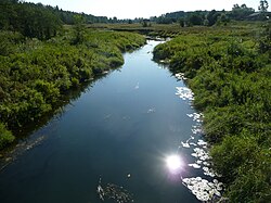 The Rachaynya River in the village of Bulatnikovo | |
 Flag  Coat of arms | |
 Location of Torzhoksky District in Tver Oblast | |
| Coordinates: 57°02′N 34°58′E / 57.033°N 34.967°E | |
| Country | Russia |
| Federal subject | Tver Oblast[1] |
| Established | 12 July 1929 |
| Administrative center | Torzhok[1] |
| Area | |
| • Total | 3,128 km2 (1,208 sq mi) |
| Population | |
| • Total | 22,534 |
| • Estimate (2018)[4] | 21,907 (−2.8%) |
| • Density | 7.2/km2 (19/sq mi) |
| • Urban | 0% |
| • Rural | 100% |
| Administrative structure | |
| • Administrative divisions | 22 rural settlement |
| • Inhabited localities | 459 rural localities |
| Municipal structure | |
| • Municipally incorporated as | Torzhoksky Municipal District[5] |
| • Municipal divisions[6] | 0 urban settlements, 22 rural settlements |
| Time zone | UTC+3 (MSK |
| OKTMO ID | 28654000 |
| Website | http://torzhokadm.ru/ |
Geography edit
The whole area of the district belongs to the drainage basin of the Volga River. A major left tributary of the Volga, the Tvertsa, crosses the district from north to south. Its biggest tributary within the district is the Osuga River (right). The rivers in the northern and the central parts of the district drain to the Tvertsa. The southern part belongs to the drainage basin of the Tma River, also a left tributary of the Volga. The Tma itself crosses the southern part of the district.
History edit
In the course of the administrative reform carried out in 1708 by Peter the Great, the area was included into Ingermanlandia Governorate (since 1710 known as Saint Petersburg Governorate), and in 1727 Novgorod Governorate split off. In 1775, Tver Viceroyalty was formed from the lands which previously belonged to Moscow and Novgorod Governorates, and the area was transferred to Tver Viceroyalty, which in 1796 was transformed to Tver Governorate. In 1775, Novotorzhsky Uyezd was established, with the center in Torzhok. The southern part of the District belonged to Staritsky Uyezd.
On July 12, 1929 the governorates and uyezds were abolished. Novotorzhsky District, with the administrative center in Torzhok, was established within Tver Okrug of Moscow Oblast. On July 23, 1930, the okrugs were abolished, and the districts were directly subordinated to the oblast. On January 29, 1935 Kalinin Oblast was established, and Novotorzhsky District was transferred to Kalinin Oblast.[11] In February 1963, during the abortive administrative reform by Nikita Khrushchev, Novotorzhsky, Likhoslavlsky, and Kamensky District were merged into a new district which was called Torzhoksky District. On March 4, 1964 Likhoslavlsky District, and on January 12, 1965 Kuvshinovsky District (which occupied the same area as the former Kamensky District) were re-established. Torzhoksky District retained the new name.[11] In 1990, Kalinin Oblast was renamed Tver Oblast.
Another district established on 12 July 1929 was Yesenovichsky District with the administrative center in the selo of Yesenovichi. It was a part of Tver Okrug of Moscow Oblast. In 1935, it was transferred to Kalinin Oblast. On August 22, 1958 Yesenovichsky District was abolished and split between Vyshnevolotsky, Novotorzhsky, Kamensky, and Firovsky Districts.[11]
On March 5, 1935 Mednovsky District with the center in the selo of Mednoye was established as well on the areas previously belonging to Kalininsky, Likhoslavlsky, and Novotorzhsky Districts. On July 4, 1956 it was abolished and split between Kalininsky and Novotorzhsky Districts.[11]
On 12 July 1929 Lukovnikovsky District, with the center in the selo of Lukovnikovo, was established. It was a part of Rzhev Okrug of Western Oblast. On 29 January 1935 Lukovnikovsky District was transferred to Kalinin Oblast. On 14 November 1960 Lukovnikovsky District was abolished and split between Kirovsky, Novotorzhsky, Staritsky, and Rzhevsky Districts.[11]
On 12 July 1929 Vysokovsky District, with the center in the settlement of Vysokoye was created as well. It was a part of Rzhev Okrug of Western Oblast. In 1930, it was abolished. On 1 June 1936, the district was re-established. On 13 February 1963 Vysokovsky District was abolished and merged into Staritsky District.[11] Later, its northern part was transferred to Torzhoksky District.[12]
Administrative and municipal status edit
Within the framework of administrative divisions, Torzhoksky District is one of the thirty-six in the oblast.[1] The town of Torzhok serves as its administrative center, despite being incorporated separately as an okrug—an administrative unit with the status equal to that of the districts.[8]
As a municipal division, the district is incorporated as Torzhoksky Municipal District.[6] Torzhok Okrug is incorporated separately from the district as Torzhok Urban Okrug.[5]
Economy edit
Agriculture edit
The main agricultural specializations of the district are cattle breeding with meat and milk production, as well as flax growing.[2]
Transportation edit
A railway line which connects Likhoslavl with Soblago via Selizharovo crosses the area of the district from east to west and passes Torzhok. Another railway line branches off in Torzhok and heads south to Rzhev via Vysokoye. Both lines are served by infrequent passenger traffic.
The M10 highway, which connects Moscow and St. Petersburg, crosses the district from south to north. In Torzhok, a road to Ostashkov branches off to the west. There is also a road connecting Torzhok with Staritsa. There are local roads as well, with the bus traffic originating from Torzhok.
Culture and recreation edit


The district contains 127 cultural heritage monuments of federal significance and additionally 178 objects classified as cultural and historical heritage of local significance. Most of the federal monuments are the buildings which belong to the ensembles of country estates, including the Gruziny Estate (18th century, the main house was built by Francesco Bartolomeo Rastrelli) and the Znamenskoye-Rayok Estate (also the 18th century, architect Nikolay Lvov), as well as exhibits of the Vasilyovo Ethnographic Museum.[13]
The ethnographic museum in Vasilyovo, just outside Torzhok, is located in the district and focuses on the wooden architecture of Tver Oblast. The museum is located in the former Lvov estate, originally built in the 18th century.[14]
References edit
Notes edit
- ^ a b c d e Государственный комитет Российской Федерации по статистике. Комитет Российской Федерации по стандартизации, метрологии и сертификации. №ОК 019-95 1 января 1997 г. «Общероссийский классификатор объектов административно-территориального деления. Код 28 254», в ред. изменения №278/2015 от 1 января 2016 г.. (State Statistics Committee of the Russian Federation. Committee of the Russian Federation on Standardization, Metrology, and Certification. #OK 019-95 January 1, 1997 Russian Classification of Objects of Administrative Division (OKATO). Code 28 254, as amended by the Amendment #278/2015 of January 1, 2016. ).
- ^ a b c Визитная карточка Торжокского района (in Russian). Torzhoksky District Administration. Retrieved November 9, 2014.
- ^ a b Russian Federal State Statistics Service (2011). Всероссийская перепись населения 2010 года. Том 1 [2010 All-Russian Population Census, vol. 1]. Всероссийская перепись населения 2010 года [2010 All-Russia Population Census] (in Russian). Federal State Statistics Service.
- ^ "26. Численность постоянного населения Российской Федерации по муниципальным образованиям на 1 января 2018 года". Federal State Statistics Service. Retrieved January 23, 2019.
- ^ a b c Law #4-ZO
- ^ a b Law #49-ZO
- ^ "Об исчислении времени". Официальный интернет-портал правовой информации (in Russian). June 3, 2011. Retrieved January 19, 2019.
- ^ a b Law #34-ZO
- ^ Federal State Statistics Service (May 21, 2004). Численность населения России, субъектов Российской Федерации в составе федеральных округов, районов, городских поселений, сельских населённых пунктов – районных центров и сельских населённых пунктов с населением 3 тысячи и более человек [Population of Russia, Its Federal Districts, Federal Subjects, Districts, Urban Localities, Rural Localities—Administrative Centers, and Rural Localities with Population of Over 3,000] (XLS). Всероссийская перепись населения 2002 года [All-Russia Population Census of 2002] (in Russian).
- ^ Всесоюзная перепись населения 1989 г. Численность наличного населения союзных и автономных республик, автономных областей и округов, краёв, областей, районов, городских поселений и сёл-райцентров [All Union Population Census of 1989: Present Population of Union and Autonomous Republics, Autonomous Oblasts and Okrugs, Krais, Oblasts, Districts, Urban Settlements, and Villages Serving as District Administrative Centers]. Всесоюзная перепись населения 1989 года [All-Union Population Census of 1989] (in Russian). Институт демографии Национального исследовательского университета: Высшая школа экономики [Institute of Demography at the National Research University: Higher School of Economics]. 1989 – via Demoscope Weekly.
- ^ a b c d e f Справка об изменениях в административно-территориальном делении Тверской губернии - Калининской области (in Russian). Архивы России. Archived from the original on April 19, 2012. Retrieved March 1, 2014.
- ^ Малыгин, П. Д.; Смирнов, С. Н. (2007). История административно-территориального деления Тверской Области (PDF). Tver. pp. 14–15. OCLC 540329541. Archived from the original (PDF) on August 29, 2021. Retrieved March 6, 2015.
{{cite book}}: CS1 maint: location missing publisher (link) - ^ Памятники истории и культуры народов Российской Федерации (in Russian). Russian Ministry of Culture. Retrieved June 2, 2016.
- ^ Архитектурно-этнографический музей под открытым небом "Василёво" (in Russian). Российская сеть культурного наследия. Retrieved November 10, 2014.
Sources edit
- Законодательное Собрание Тверской области. Закон №34-ЗО от 17 апреля 2006 г. «Об административно-территориальном устройстве Тверской области», в ред. Закона №66-ЗО от 1 октября 2014 г. «О внесении изменения в статью 18 Закона Тверской области "Об административно-территориальном устройстве Тверской области"». Вступил в силу со дня официального опубликования. Опубликован: "Тверские ведомости", №17 (специальный выпуск), 19 апреля 2006 г. (Legislative Assembly of Tver Oblast. Law #34-ZO of April 17, 2006 On the Administrative-Territorial Structure of Tver Oblast, as amended by the Law #66-ZO of October 1, 2014 On Amending Article 18 of the Law of Tver Oblast "On the Administrative-Territorial Structure of Tver Oblast". Effective as of the official publication date.).
- Законодательное Собрание Тверской области. Закон №4-ЗО от 18 января 2005 г. «Об установлении границ муниципальных образований Тверской области и наделении их статусом городских округов, муниципальных районов», в ред. Закона №65-ЗО от 24 июля 2012 г. «О внесении изменения в статью 2 Закона Тверской области "Об установлении границ муниципальных образований Тверской области и наделении их статусом городских округов, муниципальных районов"». Вступил в силу через десять дней после официального опубликования. Опубликован: "Тверские ведомости", №3, 21–27 января 2005 г. (Legislative Assembly of Tver Oblast. Law #4-ZO of January 18, 2005 On Establishing the Borders of the Municipal Formations of Tver Oblast and on Granting Them the Status of Urban Okrugs, Municipal Districts, as amended by the Law #65-ZO of July 24, 2012 On Amending Article 2 of the Law of Tver Oblast "On Establishing the Borders of the Municipal Formations of Tver Oblast and on Granting Them the Status of Urban Okrugs, Municipal Districts". Effective as of the day which is ten days after the official publication.).
- Законодательное Собрание Тверской области. Закон №49-ЗО от 28 февраля 2005 г. «Об установлении границ муниципальных образований, входящих в состав территории муниципального образования Тверской области "Торжокский район", и наделении их статусом сельского поселения», в ред. Закона №52-ЗО от 6 июня 2006 г. «О внесении изменений в отдельные Законы Тверской области, регулирующие вопросы установления границ муниципальных образований Тверской области». Вступил в силу со дня официального опубликования. Опубликован: "Тверские ведомости", №10, 11–17 марта 2005 г. (Legislative Assembly of Tver Oblast. Law #49-ZO of February 28, 2005 On Establishing the Borders of the Municipal Formations Comprised by the Territory of the Municipal Formation of "Torzhoksky District" and on Granting Them the Status of Rural Settlements, as amended by the Law #52-ZO of June 6, 2006 On Amending Various Laws of Tver Oblast Dealing with the Issues of Establishing the Borders of the Municipal Formations of Tver Oblast. Effective as of the day of the official publication.).