


Summary
Turbe is a settlement in the Travnik municipality, Federation of Bosnia and Herzegovina, Bosnia and Herzegovina.[1][2] The name is derived from the Turkish türbe.
Turbe | |
|---|---|
Village | |
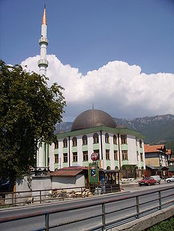 New mosque in Turbe | |
 Turbe | |
| Coordinates: 44°14′N 17°34′E / 44.24°N 17.57°E | |
| Country | |
| Entity | Federation of Bosnia and Herzegovina |
| Canton | |
| Municipality | |
| Area | |
| • Total | 0.95 sq mi (2.45 km2) |
| Highest elevation | 2,018 ft (615 m) |
| Lowest elevation | 1,952 ft (595 m) |
| Population (2013) | |
| • Total | 3,890 |
| • Density | 4,100/sq mi (1,600/km2) |
| Time zone | UTC+1 (CET) |
| • Summer (DST) | UTC+2 (CEST) |
| Area code | +387 (031) |
Population edit
| Turbe: Census Year 2013: Total of 3,890 inhabitants[3] | ||||
| Census Year | 2013. | 1991. | 1981. | 1971. |
| Bosniaks | 3.460 (88,95%) | 2.154 (47.35%) | 1.658 (47.11%) | 798 (43.94%) |
| Serbs | 39 (1,00%) | 1.056 (23.21%) | 774 (21.99%) | 486 (26.76%) |
| Croats | 255 (6,56%) | 886 (19.47%) | 731 (20.77%) | 454 (25.00%) |
| Yugoslavs | - | 309 (6.79%) | 322 (9.15%) | 60 (3.30%) |
| Others | 136 (3,50%) | 144 (3.16%) | 34 (0.96%) | 18 (0.99%) |
| Total | 3.890 | 4.549 | 3.519 | 1.816 |
Geography edit
The village of Turbe is located in the upper valley of the Lašva River, about seven kilometres west of Travnik, on the M5 towards Donji Vakuf. This is where the two headwaters Karaulska Lašva (coming from the Karaula Pass) and Komarska Lašva (coming from the Komar Pass) unite.
History edit
In the 15th century, the village was conquered by the Ottomans. In 1878, as a result of the Congress of Berlin, Turbe was placed under Austro-Hungarian administration.
During the Second World War, the village was badly destroyed. In the Battle of Travnik, in which the Yugoslav People's Liberation Army fought against Croatian NDH troops at the end of 1943, a total of 3000 people died, including 1000 civilians.
In the Bosnian war from 1992 to 1995, Turbe was directly on the front line for a long time and also the 312th Mountain Brigade of Army of Republic of Bosnia and Herzegovina was located in the region of Turbe.
Sport edit
The town's most important club is the football club NK Vlašić Turbe, which until 2007 played in the 2nd division of the Federation of Bosnia and Herzegovina, the country's five-tier 3rd division at the time
See also edit
References edit
- ^ Spahić M. et al. (2000): Bosna i Hercegovina (1:250.000). Izdavačko preduzeće „Sejtarija", Sarajevo., The Map
- ^ Mučibabić B., Ed. (1998): Geografski atlas Bosne i Hercegovine. Geodetski zavod BiH, Sarajevo, ISBN 9958-766-00-0., pp: 4-5.
- ^ "Naseljena Mjesta 1991/2013" (in Bosnian). Statistical Office of Bosnia and Herzegovina. Retrieved December 11, 2021.
- ^ "Naselje Turbe". nasbih.com.
- ^ "Nacionalni sastav stanovništva Republike Bosne i Hercegovine 1991. (str. 106)" (PDF). fzs.ba.
- ^ "Nacionalni sastav stanovništva SFR Jugoslavije 1981" (PDF). stat.gov.rs.
- ^ "Nacionalni sastav stanovništva SFR Jugoslavije 1971" (PDF). stat.gov.rs.