


Summary
Ust-Kutsky District (Russian: Усть-Ку́тский райо́н) is an administrative district, one of the thirty-three in Irkutsk Oblast, Russia.[1] Municipally, it is incorporated as Ust-Kutsky Municipal District.[8] It is located in the center of the oblast. Its administrative center is the town of Ust-Kut.[2] As of the 2010 Census, the total population of the district (excluding the administrative center) was 8,416.[4]
Ust-Kutsky District
Усть-Кутский район | |
|---|---|
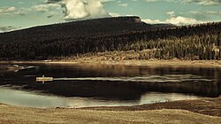 Domashny Island in the Kuta River in Ust-Kutsky District | |
 Flag  Coat of arms | |
 Location of Ust-Kutsky District in Irkutsk Oblast | |
| Coordinates: 56°48′N 105°50′E / 56.800°N 105.833°E | |
| Country | Russia |
| Federal subject | Irkutsk Oblast[1] |
| Established | 28 June 1926 |
| Administrative center | Ust-Kut[2] |
| Area | |
| • Total | 34,600 km2 (13,400 sq mi) |
| Population | |
| • Total | 8,416 |
| • Estimate (2018)[5] | 48,992 (+482.1%) |
| • Density | 0.24/km2 (0.63/sq mi) |
| • Urban | 32.7% |
| • Rural | 67.3% |
| Administrative structure | |
| • Inhabited localities[6] | 1 cities/towns, 2 Urban-type settlements[7], 17 rural localities |
| Municipal structure | |
| • Municipally incorporated as | Ust-Kutsky Municipal District[8] |
| • Municipal divisions[8] | 3 urban settlements, 4 rural settlements |
| Time zone | UTC+8 (MSK+5 |
| OKTMO ID | 25644000 |
| Website | http://admin-ukmo.ru |
| 2010 Census | 8,416[4] |
|---|---|
| 2002 Census | 10,765[10] |
| 1989 Census | 20,704[11] |
| 1979 Census | 16,567[12] |
Administrative and municipal status edit
Within the framework of administrative divisions, Ust-Kutsky District is one of the thirty-three in the oblast.[1] The town of Ust-Kut serves as its administrative center.[2] As a municipal division, the district is incorporated as Ust-Kutsky Municipal District.[8]
Geography edit
The district is located in the Lena-Angara Plateau area. The Kuta and Tayura, tributaries of the Lena River, flow across it.[13] The area of the district is 34,600 square kilometers (13,400 sq mi).[3]
References edit
Notes edit
- ^ a b c Charter of Irkutsk Oblast, Article 13
- ^ a b c Law #49-OZ
- ^ a b "Brief Historical Reference" (in Russian). Ust-Kutsky District. Retrieved June 17, 2017.
- ^ a b c Russian Federal State Statistics Service (2011). Всероссийская перепись населения 2010 года. Том 1 [2010 All-Russian Population Census, vol. 1]. Всероссийская перепись населения 2010 года [2010 All-Russia Population Census] (in Russian). Federal State Statistics Service.
- ^ "26. Численность постоянного населения Российской Федерации по муниципальным образованиям на 1 января 2018 года". Federal State Statistics Service. Retrieved January 23, 2019.
- ^ Registry of the Administrative-Territorial Formations of Irkutsk Oblast
- ^ The count of urban-type settlements may include the work settlements, the resort settlements, the suburban (dacha) settlements, as well as urban-type settlements proper.
- ^ a b c d Law #93-oz
- ^ "Об исчислении времени". Официальный интернет-портал правовой информации (in Russian). June 3, 2011. Retrieved January 19, 2019.
- ^ Federal State Statistics Service (May 21, 2004). Численность населения России, субъектов Российской Федерации в составе федеральных округов, районов, городских поселений, сельских населённых пунктов – районных центров и сельских населённых пунктов с населением 3 тысячи и более человек [Population of Russia, Its Federal Districts, Federal Subjects, Districts, Urban Localities, Rural Localities—Administrative Centers, and Rural Localities with Population of Over 3,000] (XLS). Всероссийская перепись населения 2002 года [All-Russia Population Census of 2002] (in Russian).
- ^ Всесоюзная перепись населения 1989 г. Численность наличного населения союзных и автономных республик, автономных областей и округов, краёв, областей, районов, городских поселений и сёл-райцентров [All Union Population Census of 1989: Present Population of Union and Autonomous Republics, Autonomous Oblasts and Okrugs, Krais, Oblasts, Districts, Urban Settlements, and Villages Serving as District Administrative Centers]. Всесоюзная перепись населения 1989 года [All-Union Population Census of 1989] (in Russian). Институт демографии Национального исследовательского университета: Высшая школа экономики [Institute of Demography at the National Research University: Higher School of Economics]. 1989 – via Demoscope Weekly.
- ^ Всесоюзная перепись населения 1979 г. Национальный состав населения по регионам России [All Union Population Census of 1979. Ethnic composition of the population by regions of Russia] (XLS). Всесоюзная перепись населения 1979 года [All-Union Population Census of 1979] (in Russian). 1979 – via Demoscope Weekly (website of the Institute of Demographics of the State University—Higher School of Economics.
- ^ Google Earth
Sources edit
- Законодательное Собрание Иркутской области. Постановление №9/5-ЗС от 15 апреля 2009 г. «Устав Иркутской области», в ред. Закона №2-У от 14 декабря 2017 г. «О поправках к Уставу Иркутской области». Вступил в силу по истечении десяти дней после дня официального опубликования. Опубликован: "Областная", №45, 24 апреля 2009 г. (Legislative Assembly of Irkutsk Oblast. Resolution #9/5-ZS of April 15, 2009 Charter of Irkutsk Oblast, as amended by the Law #2-U of December 14, 2017 On the Amendments to the Charter of Irkutsk Oblast. Effective as of the day following a ten-day period after the day of the official publication.).
- Законодательное Собрание Иркутской области. Закон №49-ОЗ от 21 июня 2010 г. «Об административно-территориальном устройстве Иркутской области», в ред. Закона №12-ОЗ от 23 марта 2017 г. «О внесении изменений в статьи 25 и 33 Закона Иркутской области "Об административно-территориальном устройстве Иркутской области" и Закон Иркутской области "О порядке рассмотрения Законодательным Собранием Иркутской области предложений о присвоении наименований географическим объектам и (или) о переименовании географических объектов"». Вступил в силу после дня официального опубликования. Опубликован: "Областная", №71, 25 июня 2010 г. (Legislative Assembly of Irkutsk Oblast. Law #49-OZ of June 21, 2010 On the Administrative-Territorial Structure of Irkutsk Oblast, as amended by the Law #12-OZ of March 23, 2017 On Amending Articles 25 and 33 of the Law of Irkutsk Oblast "On the Administrative-Territorial Structure of Irkutsk Oblast" and the Law of Irkutsk Oblast "On the Procedures for Consideration of Assignments of Names to Geographical Objects and (or) Renaming of Geographical Objects". Effective as of after the day of the official publication.).
- Законодательное Собрание Иркутской области. Закон №93-оз от 16 декабря 2004 г. «О статусе и границах муниципальных образований Усть-Кутского района Иркутской области», в ред. Закона №63-ОЗ от 7 июля 2015 г. «О распространении действия Закона Иркутской области "О статусе и границах муниципальных образований Черемховского района Иркутской области" на всю территорию нового субъекта Российской Федерации — Иркутской области и внесении изменений в отдельные законы Иркутской области». Вступил в силу с 31 декабря 2004 г., но не ранее чем через 10 дней со дня официального опубликования. Опубликован: "Восточно-Сибирская правда", №254–255, 20 декабря 2004 г. (Legislative Assembly of Irkutsk Oblast. Law #93-oz of December 16, 2004 On the Status and Borders of the Municipal Formations of Ust-Kutsky District of Irkutsk Oblast, as amended by the Law #63-OZ of July 7, 2015 On Expanding the Scope of the Law of Irkutsk Oblast "On the Status and Borders of the Municipal Formations of Cheremkhovsky District of Irkutsk Oblast" to the Whole Territory of the New Federal Subject of the Russian Federation—Irkutsk Oblast—and on Amending Several Laws of Irkutsk Oblast. Effective as of December 31, 2004, but not earlier than 10 days after the official publication date.).
- Registry of the Administrative-Territorial Formations of Irkutsk Oblast (in Russian)