


Summary
Ustyansky District (Russian: Устья́нский райо́н) is an administrative district (raion), one of the twenty-one in Arkhangelsk Oblast, Russia.[1] As a municipal division, it is incorporated as Ustyansky Municipal District.[8] It is located in the south of the oblast and borders with Verkhnetoyemsky District in the northeast, Krasnoborsky and Kotlassky Districts in the east, Velikoustyugsky, Nyuksensky, Tarnogsky, and Verkhovazhsky Districts, all of Vologda Oblast, in the south, Velsky District in the west, and with Shenkursky District in the northwest. The area of the district is 10,700 square kilometers (4,100 sq mi).[4] Its administrative center is the urban locality (an urban-type settlement) of Oktyabrsky.[3] Population: 30,581 (2010 Russian census);[5] 37,131 (2002 Census);[10] 45,352 (1989 Soviet census).[11] The population of Oktyabrsky accounts for 30.4% of the district's total population.[5]
Ustyansky District
Устьянский район | |
|---|---|
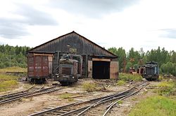 Loyginskaya railway, Ustyansky District | |
 Flag  Coat of arms | |
 Location of Ustyansky District in Arkhangelsk Oblast | |
| Coordinates: 61°05′N 43°09′E / 61.083°N 43.150°E | |
| Country | Russia |
| Federal subject | Arkhangelsk Oblast[1] |
| Established | July 15, 1929[2] |
| Administrative center | Oktyabrsky[3] |
| Area | |
| • Total | 10,700 km2 (4,100 sq mi) |
| Population | |
| • Total | 30,581 |
| • Estimate (2018)[6] | 26,606 (−13%) |
| • Density | 2.9/km2 (7.4/sq mi) |
| • Urban | 30.4% |
| • Rural | 69.6% |
| Administrative structure | |
| • Administrative divisions | 1 Urban-type settlements with jurisdictional territory, 17 Selsoviets |
| • Inhabited localities[3] | 1 Urban-type settlements[7], 232 rural localities |
| Municipal structure | |
| • Municipally incorporated as | Ustyansky Municipal District[8] |
| • Municipal divisions[8] | 1 urban settlements, 15 rural settlements |
| Time zone | UTC+3 (MSK |
| OKTMO ID | 11654000 |
| Website | http://www.ustyany.net/ |
Etymology edit
The name of the district originates from the Ustya River.
Geography edit
The district is located on the left bank of the Northern Dvina River. Most of the district's territory belongs to the basin of the Ustya River and its tributaries. The main tributaries of the Ustya are the Kizema (left), the Obil (right), and the Kokshenga (left).
Minor parts of the district in the east and in the north belong to the basins of some of the tributaries of the Northern Dvina, such as the Yumizh and the Ludonga, and drain to the northeast.
Most of the district is covered by coniferous forests (taiga).
History edit
The area was populated by speakers of Uralic languages and then colonized by the Novgorod Republic. After the fall of Novgorod, the area became a part of the Grand Duchy of Moscow. Historically, it was a part of Vazhsky Uyezd, a vast area including almost all of the basin of the Vaga River. In the course of the administrative reform carried out in 1708 by Peter the Great, the area was included into Archangelgorod Governorate. In 1780, the governorate was abolished and transformed into Vologda Viceroyalty. Vazhsky Uyezd was split, and the area of the current Ustyansky District became a part of the newly established Velsky Uyezd. In 1796, Velsky Uyezd was transferred to Vologda Governorate and remained there until 1929, when several governorates were merged into Northern Krai. On July 15, 1929, the uyezds were abolished, and Velsky Uyezd was split into Velsky, Verkhovazhsky, and Ustyansky Districts. The administrative center of Ustyansky district became the selo of Shangaly. Ustyansky District became a part of Nyandoma Okrug of Northern Krai.
In the following years, the first-level administrative division of Russia kept changing. In 1930, the okrug was abolished, and the district was subordinated to the central administration of Northern Krai. In 1936, the krai itself was transformed into Northern Oblast. In 1937, Northern Oblast was split into Arkhangelsk Oblast and Vologda Oblast. Ustyansky District remained in Arkhangelsk Oblast ever since.
On September 26, 1975, the administrative center of the district was transferred from Shangaly to Oktyabrsky, but it took some time before all of the district services were moved.[12]
From 1924 to 1959, Cherevkovsky District existed, with the administrative center in the selo of Cherevkovo, initially in Northern Dvina Governorate. On September 11, 1959, the district was abolished and split between Krasnoborsky, Verkhnetoyemsky, and Ustyansky Districts; the administrative center Cherevkovo became a part of Krasnoborsky District.
Divisions edit
Administrative divisions edit
As an administrative division, the district is divided into seventeen selsoviets and one urban-type settlement with jurisdictional territory (Oktyabrsky).[3] Three localities which previously had urban-type settlement status were downgraded to rural status. These are Ileza (downgraded in 2004), Kizema (2005), and Loyga (2005).[3] The following selsoviets have been established (the administrative centers are given in parentheses):[3]
- Bereznitsky (Bereznik);
- Bestuzhevsky (Bestuzhevo);
- Chadromsky (Chadroma);
- Cherenovsky (Kadyyevskaya);
- Dmitriyevsky (Alfyorovskaya);
- Ilezsky (Ileza);
- Kizemsky (Kizema);
- Likhachyovsky (Mirny);
- Loyginsky (Loyga);
- Malodorsky (Malodory);
- Minsky (Filinskaya);
- Orlovsky (Dubrovskaya);
- Rostovsky (Ulyanovskaya);
- Plossky (Levoplosskaya);
- Shangalsky (Shangaly);
- Sinitsky (Sinniki);
- Stroyevskoy (Stroyevskoye).
Municipal divisions edit
As a municipal division, the district is divided into one urban settlement and fifteen rural settlements (the administrative centers are given in parentheses):[8]
- Oktyabrskoye Urban Settlement (Oktyabrsky);
- Bereznitskoye Rural Settlement (Bereznik);
- Bestuzhevskoye Rural Settlement (Bestuzhevo);
- Cherenovskoye Rural Settlement (Kadyevskaya);
- Dmitriyevskoye Rural Settlement (Alfyorovskaya);
- Ilezskoye Rural Settlement (Ileza);
- Kizemskoye Rural Settlement (Kizema);
- Likhachyovskoye Rural Settlement (Mirny);
- Loyginskoye Rural Settlement (Loyga);
- Malodorskoye Rural Settlement (Malodory);
- Orlovskoye Rural Settlement (Dubrovskaya);
- Plosskoye Rural Settlement (Levoplosskaya);
- Rostovsko-Minskoye Rural Settlement (Ulyanovskaya);
- Shangalskoye Rural Settlement (Shangaly);
- Sinitskoye Rural Settlement (Kidyuga);
- Stroyevskoye Rural Settlement (Stroyevskoye).
Economy edit
Industry edit
The basis of the economy of the district is timber industry. The Ustya River was used for timber rafting until the 1990s.
Agriculture edit
Ustyansky District is marketed as a regional center of beekeeping, and Oktyabrsky holds a yearly honey festival Medovy Spas.[13]
Transportation edit
Paved roads connect Oktyabrsky with Velsk in the west and with Totma and Veliky Ustyug via Tarnogsky Gorodok in the south. There are also local roads in the district; one of which connects Oktyabrsky with the selo of Bestuzhevo in the north of the district.
A section of the railroad connecting Konosha and Kotlas, which eventually continues to Vorkuta, lies in the district. The principal station in the limits of the district is Kostylevo, several kilometers from Oktyabrsky.
Culture and recreation edit
The district previously had one object classified as cultural and historical heritage by Russian Federal law.[14] This is the wooden Church of the Nativity of the Theotokos (18th century) in the selo of Bestuzhevo, which was neglected and eventually burned down in 1994.[15] Additionally, eleven architectural monuments and ten archaeological monuments have been designated as cultural heritage monuments of local importance.[16]
The only museum in the district is the Ustyansky District Museum, which was opened in 1984 in Shangaly and moved to Oktyabrsky in 1987.[17]
Notable people edit
Notable people born in the district include the participants of World War II Roza Shanina and Aleksandr Yedemsky.
References edit
Notes edit
- ^ a b Law #65-5-OZ
- ^ Постановление Президиума ВЦИК от 15 июля 1929 года о составе округов и районов Северного Края и их центрах (in Russian). consultant.ru. Retrieved June 4, 2011.
- ^ a b c d e f Государственный комитет Российской Федерации по статистике. Комитет Российской Федерации по стандартизации, метрологии и сертификации. №ОК 019-95 1 января 1997 г. «Общероссийский классификатор объектов административно-территориального деления. Код 11 254», в ред. изменения №278/2015 от 1 января 2016 г.. (State Statistics Committee of the Russian Federation. Committee of the Russian Federation on Standardization, Metrology, and Certification. #OK 019-95 January 1, 1997 Russian Classification of Objects of Administrative Division (OKATO). Code 11 254, as amended by the Amendment #278/2015 of January 1, 2016. ).
- ^ a b Устьянский район (in Russian). Двина-Информ. Retrieved August 4, 2011.
- ^ a b c Russian Federal State Statistics Service (2011). Всероссийская перепись населения 2010 года. Том 1 [2010 All-Russian Population Census, vol. 1]. Всероссийская перепись населения 2010 года [2010 All-Russia Population Census] (in Russian). Federal State Statistics Service.
- ^ "26. Численность постоянного населения Российской Федерации по муниципальным образованиям на 1 января 2018 года". Federal State Statistics Service. Retrieved January 23, 2019.
- ^ The count of urban-type settlements may include the work settlements, the resort settlements, the suburban (dacha) settlements, as well as urban-type settlements proper.
- ^ a b c d Law #258-vneoch.-OZ
- ^ "Об исчислении времени". Официальный интернет-портал правовой информации (in Russian). June 3, 2011. Retrieved January 19, 2019.
- ^ Federal State Statistics Service (May 21, 2004). Численность населения России, субъектов Российской Федерации в составе федеральных округов, районов, городских поселений, сельских населённых пунктов – районных центров и сельских населённых пунктов с населением 3 тысячи и более человек [Population of Russia, Its Federal Districts, Federal Subjects, Districts, Urban Localities, Rural Localities—Administrative Centers, and Rural Localities with Population of Over 3,000] (XLS). Всероссийская перепись населения 2002 года [All-Russia Population Census of 2002] (in Russian).
- ^ Всесоюзная перепись населения 1989 г. Численность наличного населения союзных и автономных республик, автономных областей и округов, краёв, областей, районов, городских поселений и сёл-райцентров [All Union Population Census of 1989: Present Population of Union and Autonomous Republics, Autonomous Oblasts and Okrugs, Krais, Oblasts, Districts, Urban Settlements, and Villages Serving as District Administrative Centers]. Всесоюзная перепись населения 1989 года [All-Union Population Census of 1989] (in Russian). Институт демографии Национального исследовательского университета: Высшая школа экономики [Institute of Demography at the National Research University: Higher School of Economics]. 1989 – via Demoscope Weekly.
- ^ Гневанова, Л. К. (March 13, 2010). Историческая справка Устьянского районного суда Архангельской области (in Russian). Устьянский районный суд. Retrieved June 5, 2011.
- ^ Чем мы гордимся! (in Russian). Администрация Устьянского района. Retrieved June 5, 2011.
- ^ Памятники истории и культуры народов Российской Федерации (in Russian). Russian Ministry of Culture. Retrieved June 2, 2016.
- ^ История (in Russian). Администрация Устьянского района. Retrieved June 4, 2011.
- ^ Список памятников Архангельской области (in Russian). Администрация Архангельской области. August 13, 1998. Retrieved November 13, 2011.
- ^ Муниципальное учреждение культуры "Устьянский краеведческий музей" (in Russian). Российская сеть культурного наследия. Retrieved May 26, 2011.
Sources edit
- Архангельское областное Собрание депутатов. Областной закон №65-5-ОЗ от 23 сентября 2009 г. «Об административно-территориальном устройстве Архангельской области», в ред. Областного закона №232-13-ОЗ от 16 декабря 2014 г. «О внесении изменений в отдельные Областные Законы в сфере осуществления местного самоуправления и взаимодействия с некоммерческими организациями». Вступил в силу через десять дней со дня официального опубликования. Опубликован: "Волна", №43, 6 октября 2009 г. (Arkhangelsk Oblast Council of Deputies. Oblast Law #65-5-OZ of September 23, 2009 On the Administrative-Territorial Structure of Arkhangelsk Oblast, as amended by the Oblast Law #232-13-OZ of December 16, 2014 On Amending Various Oblast Laws Dealing with the Process of Municipal Self-Government and Relations with Non-Profit Organizations. Effective as of the day which is ten days after the official publication.).
- Архангельское областное Собрание депутатов. Областной закон №258-внеоч.-ОЗ от 23 сентября 2004 г. «О статусе и границах территорий муниципальных образований в Архангельской области», в ред. Областного закона №224-13-ОЗ от 16 декабря 2014 г. «Об упразднении отдельных населённых пунктов Соловецкого района Архангельской области и о внесении изменения в статью 46 Областного закона "О статусе и границах территорий муниципальных образований в Архангельской области"». Вступил в силу со дня официального опубликования. Опубликован: "Волна", №38, 8 октября 2004 г. (Arkhangelsk Oblast Council of Deputies. Oblast Law #258-vneoch.-OZ of September 23, 2004 On the Status and Borders of the Territories of the Municipal Formations in Arkhangelsk Oblast, as amended by the Oblast Law #224-13-OZ of December 16, 2014 On Abolishing Several Inhabited Localities in Solovetsky District of Arkhangelsk Oblast and on Amending Article 46 of the Oblast Law "On the Status and Borders of the Territories of the Municipal Formations in Arkhangelsk Oblast". Effective as of the day of the official publication.).