


Summary
Vashkinsky District (Russian: Ва́шкинский райо́н) is an administrative[1] and municipal[7] district (raion), one of the twenty-six in Vologda Oblast, Russia. It is located in the northwest of the oblast and borders with Vytegorsky District in the north, Kirillovsky District in the east, and with Belozersky District in the south and west. The area of the district is 2,900 square kilometers (1,100 sq mi).[4] Its administrative center is the rural locality (a selo) of Lipin Bor.[3] District's population: 8,089 (2010 Russian census);[5] 10,002 (2002 Census);[9] 11,977 (1989 Soviet census).[10] The population of Lipin Bor accounts for 45.4% of the district's total population.[9]
Vashkinsky District
Вашкинский район | |
|---|---|
 Flag  Coat of arms | |
 Location of Vashkinsky District in Vologda Oblast | |
| Coordinates: 60°16′N 37°59′E / 60.267°N 37.983°E | |
| Country | Russia |
| Federal subject | Vologda Oblast[1] |
| Established | August 1, 1927[2] |
| Administrative center | Lipin Bor[3] |
| Area | |
| • Total | 2,900 km2 (1,100 sq mi) |
| Population | |
| • Total | 8,089 |
| • Estimate (2018)[6] | 6,771 (−16.3%) |
| • Density | 2.8/km2 (7.2/sq mi) |
| • Urban | 0% |
| • Rural | 100% |
| Administrative structure | |
| • Administrative divisions | 12 Selsoviets |
| • Inhabited localities[3] | 197 rural localities |
| Municipal structure | |
| • Municipally incorporated as | Vashkinsky Municipal District[7] |
| • Municipal divisions[7] | 0 urban settlements, 3 rural settlements |
| Time zone | UTC+3 (MSK |
| OKTMO ID | 19612000 |
| Website | http://lipinbor.ru |
Geography edit
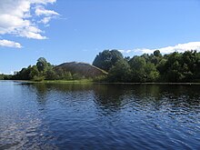
The district is located northeast of Lake Beloye and the area of the lake is divided between Vashkinsky and Belozersky Districts. Much of the area of the district belongs to the basin of Lake Beloye and thus of the Caspian Sea. In particular, the Kovzha River, one of the main tributaries of the lake, forms the western border of the district, and the Kema River, another major tributary, crosses the district from north to south. Most of the area of the district is in the Kema's drainage basin. The eastern and northeastern parts of the district belong to the basin of the Onega River, which flows to the White Sea.
There are many lakes in the district, the biggest of which are Lake Druzhinnoye, Lake Volotskoye, Lake Unzhinskoye, and Lake Pushtorskoye, all belonging to the basin of Lake Beloye.
History edit
The name "Vashky" originates from Finnic languages where "vaskala" means a type of fish - Common bleak.
According to the Primary Chronicle, Sineus, a brother of Rurik, became the prince of Beloozero in 862. However, it is likely that Sineus never existed.[11] Nevertheless, the archaeological data show that the settlement existed until the 10th century on the northern shore of the lake, close to the selo of Kisnema (now Troitskoye in Vashkinsky District). In the 10th century, it was transferred to the outflow of the Sheksna River. The area was under the influence of the Novgorod Republic and the Novgorodians used the waterway to the White Sea which runs through the current area of the district.[12] In the 13th century, the area was administered by princes of Beloozero, and then in the 14th century, it fell under control of the Grand Duchy of Moscow.
In the course of the administrative reform carried out in 1708 by Peter the Great, the area was included into Ingermanland Governorate (known since 1710 as Saint Petersburg Governorate). In 1727, separate Novgorod Governorate was split off. The area became a part of Belozersky Uyezd of Belozersk Oblast of Novgorod Governorate.[4] In 1776, the area was transferred to Novgorod Viceroyalty. In 1796, the viceroyalty was abolished, and the area was transferred to Novgorod Governorate. In the 19th century, the area was transferred to Kirillovsky Uyezd.
In June 1918, five uyezds of Novgorod Governorate, including Kirillovsky Uyezd, were split off to form Cherepovets Governorate, with the administrative center in Cherepovets. On August 1, 1927, Cherepovets Governorate was abolished and its area became Cherepovets Okrug of Leningrad Oblast. Simultaneously, the uyezds were abolished and Vashkinsky District was established. The administrative center of the district was established in the village of Vashki, hence the name of the district.[13] On September 23, 1937, Vashkinsky District was transferred to newly established Vologda Oblast.[2] In 1938, the administrative center of the district was moved to the selo of Lipin Bor.
On August 1, 1927, Kovzhinsky District (with the administrative center in the selo of Annensky Most[14]) and Sholsky District (with the administrative center in the selo of Zubovo[15]) were also established. In 1937, they were transferred from Leningrad Oblast to Vologda Oblast. In 1959, both districts were abolished. The area of Sholsky District was split between Vashkinsky and Belozersky Districts, and the area of Kovzhinsky District was split between Vashkinsky and Vytegorsky Districts.[2]
Economy edit
Industry edit
The industry of the district is essentially food industry and timber industry.[16]
Agriculture edit
There are seven farms in the district, and the number of employees in agriculture in 2010 was 325. The main specializations are cattle breeding (meat and milk production) and crops growing.[17]
Transportation edit
A highway connecting Vologda and Vytegra crosses the district bypassing Lipin Bor. Another road branches off south, running via Lipin Bor to Belozersk. There are also local roads with bus traffic.
The Volga–Baltic Waterway (formerly known as the Mariinsk Canal System), connecting the Rybinsk Reservoir in the basin of the Volga River with Lake Onega in the basin of the Neva River, runs through the district, following the course of the Kovzha River. Lake Beloye is also a part of the Volga-Baltic Waterway.
Culture and recreation edit

The district contains two cultural heritage monuments of federal significance (both are archaeological monuments which are the remains of former settlements) and forty-three objects classified as cultural and historical heritage of local significance.[18] Most of these are wooden farms built prior to 1917.
Vashkinsky District Museum is located in Lipin Bor.[19]
References edit
Notes edit
- ^ a b Law #371-OZ
- ^ a b c Справка об изменениях административно-территориального устройства и сети партийных и комсомольских органов на территории Вологодской области (1917-1991) (in Russian). Архивы России. Retrieved October 16, 2011.
- ^ a b c Resolution #178
- ^ a b c Судаков, Г.В. (2006). Г. В. Судаков (ed.). Вологодская энциклопедия (PDF) (in Russian). Вологда: ВГПУ, Русь. p. 90. ISBN 5-87822-305-8. Retrieved November 14, 2011.
- ^ a b Russian Federal State Statistics Service (2011). Всероссийская перепись населения 2010 года. Том 1 [2010 All-Russian Population Census, vol. 1]. Всероссийская перепись населения 2010 года [2010 All-Russia Population Census] (in Russian). Federal State Statistics Service.
- ^ "26. Численность постоянного населения Российской Федерации по муниципальным образованиям на 1 января 2018 года". Federal State Statistics Service. Retrieved January 23, 2019.
- ^ a b c Law #1108-OZ
- ^ "Об исчислении времени". Официальный интернет-портал правовой информации (in Russian). June 3, 2011. Retrieved January 19, 2019.
- ^ a b Federal State Statistics Service (May 21, 2004). Численность населения России, субъектов Российской Федерации в составе федеральных округов, районов, городских поселений, сельских населённых пунктов – районных центров и сельских населённых пунктов с населением 3 тысячи и более человек [Population of Russia, Its Federal Districts, Federal Subjects, Districts, Urban Localities, Rural Localities—Administrative Centers, and Rural Localities with Population of Over 3,000] (XLS). Всероссийская перепись населения 2002 года [All-Russia Population Census of 2002] (in Russian).
- ^ Всесоюзная перепись населения 1989 г. Численность наличного населения союзных и автономных республик, автономных областей и округов, краёв, областей, районов, городских поселений и сёл-райцентров [All Union Population Census of 1989: Present Population of Union and Autonomous Republics, Autonomous Oblasts and Okrugs, Krais, Oblasts, Districts, Urban Settlements, and Villages Serving as District Administrative Centers]. Всесоюзная перепись населения 1989 года [All-Union Population Census of 1989] (in Russian). Институт демографии Национального исследовательского университета: Высшая школа экономики [Institute of Demography at the National Research University: Higher School of Economics]. 1989 – via Demoscope Weekly.
- ^ Рюрик - Синеус - Трувор. Great Soviet Encyclopedia.
- ^ История района. Официальный сайт Вашкинского муниципального района (in Russian). Retrieved September 10, 2014.
- ^ Исторические события (in Russian). Департамент развития муниципальных образований Вологодской области. Archived from the original on April 25, 2012. Retrieved November 16, 2011.
- ^ Ковжинский район (авг. 1927 – сент. 1937) (in Russian). Система классификаторов исполнительных органов государственной власти Санкт-Петербурга. Retrieved November 16, 2011.
- ^ Шольский район (авг. 1927 – сент. 1937) (in Russian). Система классификаторов исполнительных органов государственной власти Санкт-Петербурга. Retrieved November 16, 2011.
- ^ Промышленность (in Russian). Официальный сайт Вашкинского муниципального района. Retrieved November 15, 2011.[permanent dead link]
- ^ Сельское хозяйство (in Russian). Официальный сайт Вашкинского муниципального района. Retrieved November 15, 2011.[permanent dead link]
- ^ Памятники истории и культуры народов Российской Федерации (in Russian). Russian Ministry of Culture. Retrieved June 2, 2016.
- ^ Культура (in Russian). Официальный сайт Вашкинского муниципального района Вологодской области. Retrieved November 16, 2011.
Sources edit
- Законодательное Собрание Вологодской области. Закон №371-ОЗ от 4 июня 1999 г. «О вопросах административно-территориального устройства Вологодской области», в ред. Закона №2916-ОЗ от 7 декабря 2012 г. «О внесении изменений в Закон области "О вопросах административно-территориального устройства Вологодской области"». Вступил в силу со дня официального опубликования. Опубликован: "Красный Север", №124–125, 29 июля 1999 г. (Legislative Assembly of Vologda Oblast. Law #371-OZ of June 4, 1999 On the Matters of the Administrative-Territorial Structure of Vologda Oblast, as amended by the Law #2916-OZ of December 7, 2012 On Amending the Oblast Law "On the Matters of the Administrative-Territorial Structure of Vologda Oblast". Effective as of the day of the official publication.).
- Правительство Вологодской области. Постановление №178 от 1 марта 2010 г. «Об утверждении реестра административно-территориальных единиц Вологодской области», в ред. Постановления №686 от 25 июня 2012 г. «О внесении изменений в некоторые Постановления Правительства области». Вступил в силу 20 марта 2010 г. Опубликован: "Красный Север", №29, 20 марта 2010 г. (Government of Vologda Oblast. Resolution #178 of March 1, 2010 On Adopting the Registry of the Administrative-Territorial Units of Vologda Oblast, as amended by the Resolution #686 of June 25, 2012 On Amending Various Resolutions of the Oblast Government. Effective as of March 20, 2010.).
- Законодательное Собрание Вологодской области. Закон №1108-ОЗ от 6 декабря 2004 г. «Об установлении границ Вашкинского муниципального района, границах и статусе муниципальных образований, входящих в его состав», в ред. Закона №3689-ОЗ от 25 июня 2015 г. «О преобразовании некоторых муниципальных образований Вашкинского муниципального района, о внесении изменений в Закон области "Об установлении границ Вашкинского муниципального района, границах и статусе муниципальных образований, входящих в его состав" и изменения в Приложение к Закону области "О некоторых вопросах организации и деятельности органов местного самоуправления на территории Вологодской области"». Вступил в силу через 10 дней со дня официального опубликования. Опубликован: "Красный Север", №242, 11 декабря 2004 г. (Legislative Assembly of Vologda Oblast. Law #1108-OZ of December 6, 2004 On Establishing the Borders of Vashkinsky Municipal District, on the Borders and Status of the Municipal Formations It Comprises, as amended by the Law #3689-OZ of June 25, 2015 On the Transformation of Several Municipal Formations in Vashkinsky Municipal District, on Amending the Law of the Oblast "On Establishing the Borders of Vashkinsky Municipal District, on the Borders and Status of the Municipal Formations It Comprises", and on Amending the Appendix to the Law of the Oblast "On Various Issues of Organization and Functioning of the Local Self-Government on the Territory of Vologda Oblast". Effective as of after 10 days from the day of the official publication.).