


Summary
Vorotynsk (Russian: Вороты́нск) is a former town located 17 km south of Kaluga in the Ugra National Park.[3] The town is thought to have been situated slightly downstream from the confluence of the Oka and the Ugra Rivers.
Vorotynsk
Вороты́нск | |
|---|---|
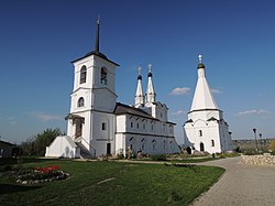 Saviour Monastery | |
Location of Vorotynsk .mw-parser-output .locmap .od{position:absolute}.mw-parser-output .locmap .id{position:absolute;line-height:0}.mw-parser-output .locmap .l0{font-size:0;position:absolute}.mw-parser-output .locmap .pv{line-height:110%;position:absolute;text-align:center}.mw-parser-output .locmap .pl{line-height:110%;position:absolute;top:-0.75em;text-align:right}.mw-parser-output .locmap .pr{line-height:110%;position:absolute;top:-0.75em;text-align:left}.mw-parser-output .locmap .pv>div{display:inline;padding:1px}.mw-parser-output .locmap .pl>div{display:inline;padding:1px;float:right}.mw-parser-output .locmap .pr>div{display:inline;padding:1px;float:left}html.skin-theme-clientpref-night .mw-parser-output .od,html.skin-theme-clientpref-night .mw-parser-output .od .pv>div,html.skin-theme-clientpref-night .mw-parser-output .od .pl>div,html.skin-theme-clientpref-night .mw-parser-output .od .pr>div{background:#000;color:#fff}html.skin-theme-clientpref-night .mw-parser-output .locmap{filter:grayscale(0.6)}@media(prefers-color-scheme:dark){html.skin-theme-clientpref-os .mw-parser-output .locmap{filter:grayscale(0.6)}html.skin-theme-clientpref-os .mw-parser-output .od,html.skin-theme-clientpref-os .mw-parser-output .od .pv>div,html.skin-theme-clientpref-os .mw-parser-output .od .pl>div,html.skin-theme-clientpref-os .mw-parser-output .od .pr>div{background:#000;color:#fff}} 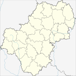 Vorotynsk Location of Vorotynsk 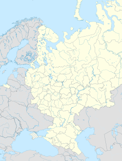 Vorotynsk Vorotynsk (European Russia)  Vorotynsk Vorotynsk (Russia) | |
| Coordinates: 54°25′47″N 36°02′44″E / 54.42972°N 36.04556°E | |
| Country | Russia |
| Federal subject | Kaluga Oblast |
| Administrative district | Peremyshlsky District |
| First mentioned | 1155 |
| Time zone | UTC+3 (MSK |
| Postal code(s)[2] | 249120 |
| OKTMO ID | 29632412106 |
It was one of the Upper Oka towns and seat of the mediaeval Princes Vorotynsky. It was first mentioned in the Hypatian Codex under the year 1155.[4] In the 14th century, it came under Lithuanian suzerainty as a fief.[4] In 1480, Vorotynsk was the principal Tatar base during the Great standing on the Ugra river. In 1493, it passed under suzerainty of the Grand Duchy of Moscow.[4]
The village of Spas-on-the-Oka, which now marks the spot, is dominated by Saviour Vorotynsk Monastery, founded by one Prince Vorotynsky in the early 16th century. It is noted for two rare churches with pyramidal roofs, one dating from the 1560s, and another from the 1640s. There are also two villages, New Vorotynsk and Old Vorotynsk, located just south-west from the modern town of Kaluga.
References edit
- ^ "Об исчислении времени". Официальный интернет-портал правовой информации (in Russian). 3 June 2011. Retrieved 19 January 2019.
- ^ Почта России. Информационно-вычислительный центр ОАСУ РПО. (Russian Post). Поиск объектов почтовой связи (Postal Objects Search) (in Russian)
- ^ "Общие сведения о парке" (in Russian). Ugra National Park. Retrieved 31 December 2015.
- ^ a b c Słownik geograficzny Królestwa Polskiego i innych krajów słowiańskich, Tom XIII (in Polish). Warszawa. 1893. p. 960.
{{cite book}}: CS1 maint: location missing publisher (link)