


Summary
Xi County or Xixian (simplified Chinese: 隰县; traditional Chinese: 隰縣; pinyin: Xī Xiàn) is a county in the southwest of Shanxi province, China. It is located in the northwest of the administrative area of the prefecture-level city of Linfen. The county spans an area of 1,413 square kilometres (546 sq mi),[1] and according to the 2010 Chinese census, Xi County had a population of 103,617.[2]
Xi County
隰县 | |
|---|---|
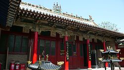 Daxiong Hall, Xiaoxitian, Xi County | |
 Xi County in Linfen | |
 Linfen in Shanxi | |
| Country | People's Republic of China |
| Province | Shanxi |
| Prefecture-level city | Linfen |
| Area | |
| • Total | 1,413 km2 (546 sq mi) |
| Population (2010) | |
| • Total | 103,617 |
| • Density | 73/km2 (190/sq mi) |
| Time zone | UTC+8 (China Standard) |
Toponymy edit
The county was named after a definition in the Erya which stated "that which is wet shall be called xi" (simplified Chinese: 下湿曰隰; traditional Chinese: 下濕曰隰; pinyin: xià shī yuē xí), in reference to the county's wet period during the spring.[2]
History edit
During the Han dynasty, the area was organized as Puzi County (simplified Chinese: 蒲子县; traditional Chinese: 蒲子縣; pinyin: Púzi Xiàn).[2]
Under the Northern Wei, the northern portion of present-day Xi County was organized as part of Tujing Commandery, and the southern portion was part of Pingchang County (simplified Chinese: 平昌县; traditional Chinese: 平昌縣; pinyin: Píngchāng Xiàn).[2]
In 579 CE, the Northern Zhou established Changshou County (simplified Chinese: 长寿县; traditional Chinese: 長壽縣; pinyin: Chángshòu Xiàn) in the area, under the jurisdiction of Longquan Commandery.[2]
In 585 CE, the area was reorganized as Xi Zhou, which existed on and off until the area was reorganized as Xichuan County (simplified Chinese: 隰川县; traditional Chinese: 隰川縣; pinyin: Xíchuān Xiàn) in the mid 14th century.[2]
In 1912, the area was reorganized as Xi County, as it is today, belonging to Hedong Circuit.[2]
Under the People's Republic of China, the county was under the jurisdiction of Jinnan Prefecture, until it was reorganized as Linfen in 1970.[2]
Geography edit
The county is located on the western edge of the Lüliang Mountains, with an average elevation ranging from 950 metres (3,120 ft) to 1,300 metres (4,300 ft) above sea level.[1] Xi County's highest point is 1,953 metres (6,407 ft) above sea level.[1]
The Xinshui River, a tributary of the Yellow River, flows through the county.[1]
Climate edit
| Climate data for Xixian (1991–2020 normals, extremes 1981–2010) | |||||||||||||
|---|---|---|---|---|---|---|---|---|---|---|---|---|---|
| Month | Jan | Feb | Mar | Apr | May | Jun | Jul | Aug | Sep | Oct | Nov | Dec | Year |
| Record high °C (°F) | 17.0 (62.6) |
22.6 (72.7) |
28.6 (83.5) |
35.2 (95.4) |
36.4 (97.5) |
38.1 (100.6) |
38.5 (101.3) |
37.5 (99.5) |
36.4 (97.5) |
28.3 (82.9) |
23.9 (75.0) |
16.0 (60.8) |
38.5 (101.3) |
| Mean daily maximum °C (°F) | 1.6 (34.9) |
6.0 (42.8) |
12.5 (54.5) |
19.8 (67.6) |
24.9 (76.8) |
28.8 (83.8) |
29.6 (85.3) |
27.8 (82.0) |
23.1 (73.6) |
17.1 (62.8) |
9.9 (49.8) |
2.9 (37.2) |
17.0 (62.6) |
| Daily mean °C (°F) | −5.8 (21.6) |
−1.5 (29.3) |
4.9 (40.8) |
12.0 (53.6) |
17.3 (63.1) |
21.5 (70.7) |
23.1 (73.6) |
21.4 (70.5) |
16.3 (61.3) |
9.8 (49.6) |
2.6 (36.7) |
−4.1 (24.6) |
9.8 (49.6) |
| Mean daily minimum °C (°F) | −10.8 (12.6) |
−6.8 (19.8) |
−1.0 (30.2) |
5.2 (41.4) |
10.2 (50.4) |
14.9 (58.8) |
17.8 (64.0) |
16.5 (61.7) |
11.3 (52.3) |
4.5 (40.1) |
−2.3 (27.9) |
−8.9 (16.0) |
4.2 (39.6) |
| Record low °C (°F) | −23.6 (−10.5) |
−19.6 (−3.3) |
−15.6 (3.9) |
−8.4 (16.9) |
0.3 (32.5) |
5.6 (42.1) |
11.0 (51.8) |
8.1 (46.6) |
0.0 (32.0) |
−7.7 (18.1) |
−19.0 (−2.2) |
−24.2 (−11.6) |
−24.2 (−11.6) |
| Average precipitation mm (inches) | 4.6 (0.18) |
6.9 (0.27) |
11.1 (0.44) |
29.8 (1.17) |
38.6 (1.52) |
54.9 (2.16) |
111.1 (4.37) |
113.5 (4.47) |
69.7 (2.74) |
38.1 (1.50) |
17.3 (0.68) |
3.6 (0.14) |
499.2 (19.64) |
| Average precipitation days (≥ 0.1 mm) | 2.8 | 3.4 | 4.5 | 6.0 | 7.8 | 9.3 | 12.7 | 11.2 | 9.1 | 7.3 | 4.5 | 2.6 | 81.2 |
| Average snowy days | 4.2 | 4.7 | 3.1 | 0.5 | 0 | 0 | 0 | 0 | 0 | 0.2 | 2.6 | 3.7 | 19 |
| Average relative humidity (%) | 53 | 50 | 45 | 44 | 48 | 55 | 68 | 72 | 71 | 66 | 59 | 54 | 57 |
| Mean monthly sunshine hours | 188.6 | 176.2 | 210.9 | 233.9 | 253.3 | 235.2 | 219.8 | 205.2 | 184.9 | 195.1 | 182.5 | 188.1 | 2,473.7 |
| Percent possible sunshine | 61 | 57 | 57 | 59 | 58 | 54 | 50 | 50 | 50 | 57 | 60 | 63 | 56 |
| Source: China Meteorological Administration[3][4] | |||||||||||||
Administrative divisions edit
Xi County administers three towns and five townships.[5]
Towns edit
The county's three towns are Longquan, Wucheng, and Huangtu.[5]
Townships edit
The county's five townships are Yangtousheng Township, Zhaizi Township, Duopo Township, Xiali Township, and Chengnan Township.[5]
Demographics edit
The county's population per the 2010 Chinese census was 103,617, up from the 95,895 reported in the 2000 Chinese census.[2] In 1999, the county's population was estimated to be 97,758.[2]
References edit
- ^ a b c d 隰县概况地图 [Xi County Overview]. xzqh.org (in Chinese). 2016-10-18. Archived from the original on 2021-05-07. Retrieved 2021-05-07.
- ^ a b c d e f g h i j 隰县历史沿革 [Xi County Organizational History]. xzqh.org (in Chinese). 2016-11-08. Archived from the original on 2021-05-07. Retrieved 2021-05-07.
- ^ 中国气象数据网 – WeatherBk Data (in Simplified Chinese). China Meteorological Administration. Retrieved 26 August 2023.
- ^ 中国气象数据网 (in Simplified Chinese). China Meteorological Administration. Retrieved 26 August 2023.
- ^ a b c 2020年统计用区划代码(隰县) [2020 Statistical Division Codes (Xi County)] (in Chinese). National Bureau of Statistics of China. 2020. Archived from the original on 2021-05-07. Retrieved 2021-05-07.
36°42′42″N 111°00′00″E / 36.71167°N 111.00000°E