


Summary
Xinye (Chinese: 新野; pinyin: Xīnyě; Wade–Giles: Hsin-yeh) is one of the counties of Nanyang[3] that lies in the southwest of Henan province, China. To the south lies the prefecture-level city of Xiangyang in Hubei province, to the east is Tanghe County and to the west is the county-level city of Dengzhou. Xinye county has a population of 730,000[when?]. Its total area is 1,062 km2 (410 sq mi).
Xinye County
新野县 Sinyeh | |
|---|---|
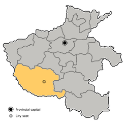
 Xinye in Nanyang | |
 Nanyang in Henan | |
| Coordinates: 32°31′15″N 112°21′36″E / 32.5209°N 112.3601°E | |
| Country | People's Republic of China |
| Province | Henan |
| Prefecture-level city | Nanyang |
| Area | |
| • Total | 1,056 km2 (408 sq mi) |
| Population (2019)[2] | |
| • Total | 633,600 |
| • Density | 600/km2 (1,600/sq mi) |
| Time zone | UTC+8 (China Standard) |
| Postal code | 473500 |
The G55 Erenhot–Guangzhou Expressway runs through Waizi town, which is the northmost town of Xinye. Both Nanyang Jiangying Airport and Xiangyang Liuji Airport are about 60 km (37 mi) away from Xinye.

History edit
Near the end of the Han Dynasty, the warlord Liu Bei used Xinye as a base, as a vassal under Liu Biao. Liu Biao himself had been residing in Xiangyang (today's Xiangfan). Liu Bei lost Xinye to Cao Cao in 208 and retreated to the southeast in prelude to the battle of the Red Cliffs.[4]
Administrative divisions edit
As 2012, this county is divided to 2 subdistricts, 8 towns and 5 townships.[5]
- Subdistricts
- Hanhua Subdistrict (汉华街道)
- Hancheng Subdistrict (汉城街道)
- Towns
|
|
- Townships
|
|
Climate edit
| Climate data for Xinye (1991–2020 normals, extremes 1981–2010) | |||||||||||||
|---|---|---|---|---|---|---|---|---|---|---|---|---|---|
| Month | Jan | Feb | Mar | Apr | May | Jun | Jul | Aug | Sep | Oct | Nov | Dec | Year |
| Record high °C (°F) | 21.7 (71.1) |
22.9 (73.2) |
28.9 (84.0) |
33.2 (91.8) |
38.9 (102.0) |
40.2 (104.4) |
39.8 (103.6) |
38.2 (100.8) |
40.3 (104.5) |
33.2 (91.8) |
30.3 (86.5) |
21.4 (70.5) |
40.3 (104.5) |
| Mean daily maximum °C (°F) | 7.2 (45.0) |
10.8 (51.4) |
15.8 (60.4) |
22.2 (72.0) |
27.6 (81.7) |
31.3 (88.3) |
32.0 (89.6) |
31.3 (88.3) |
27.5 (81.5) |
22.6 (72.7) |
15.6 (60.1) |
9.5 (49.1) |
21.1 (70.0) |
| Daily mean °C (°F) | 2.2 (36.0) |
5.1 (41.2) |
10.1 (50.2) |
16.1 (61.0) |
21.6 (70.9) |
25.8 (78.4) |
27.5 (81.5) |
26.6 (79.9) |
22.2 (72.0) |
16.8 (62.2) |
10.0 (50.0) |
4.2 (39.6) |
15.7 (60.2) |
| Mean daily minimum °C (°F) | −1.7 (28.9) |
0.7 (33.3) |
5.3 (41.5) |
10.9 (51.6) |
16.4 (61.5) |
21.3 (70.3) |
23.9 (75.0) |
23.1 (73.6) |
18.4 (65.1) |
12.4 (54.3) |
5.8 (42.4) |
0.1 (32.2) |
11.4 (52.5) |
| Record low °C (°F) | −12.6 (9.3) |
−12.3 (9.9) |
−8.1 (17.4) |
−0.2 (31.6) |
4.9 (40.8) |
11.3 (52.3) |
17.6 (63.7) |
13.9 (57.0) |
8.7 (47.7) |
−0.2 (31.6) |
−5.5 (22.1) |
−14.3 (6.3) |
−14.3 (6.3) |
| Average precipitation mm (inches) | 15.0 (0.59) |
17.5 (0.69) |
36.6 (1.44) |
50.0 (1.97) |
89.5 (3.52) |
106.4 (4.19) |
143.0 (5.63) |
110.7 (4.36) |
70.0 (2.76) |
58.1 (2.29) |
34.5 (1.36) |
13.5 (0.53) |
744.8 (29.33) |
| Average precipitation days (≥ 0.1 mm) | 4.8 | 6.1 | 7.8 | 8.3 | 10.2 | 9.4 | 11.0 | 10.0 | 9.4 | 8.8 | 6.9 | 5.1 | 97.8 |
| Average snowy days | 4.2 | 3.0 | 1.0 | 0 | 0 | 0 | 0 | 0 | 0 | 0 | 0.8 | 2.3 | 11.3 |
| Average relative humidity (%) | 72 | 71 | 73 | 74 | 71 | 73 | 82 | 82 | 77 | 74 | 75 | 72 | 75 |
| Mean monthly sunshine hours | 109.6 | 115.4 | 145.5 | 172.4 | 185.3 | 172.9 | 178.5 | 182.3 | 148.3 | 143.6 | 127.6 | 122.1 | 1,803.5 |
| Percent possible sunshine | 34 | 37 | 39 | 44 | 43 | 41 | 41 | 45 | 40 | 41 | 41 | 39 | 40 |
| Source: China Meteorological Administration[6][7] | |||||||||||||
References edit
- ^ 最新人口信息 www.hongheiku.com (in Chinese). hongheiku. Retrieved 2021-01-12.
- ^ 最新人口信息 www.hongheiku.com (in Chinese). hongheiku. Retrieved 2021-01-12.
- ^ Bernstein, Thomas P.; Xiaobo Lü (2003). Taxation without Representation in Contemporary Rural China. Cambridge University Press. p. 157. ISBN 9781139438049.
- ^ Liangyan Ge (2015). The Scholar and the State: Fiction as Political Discourse in Late Imperial China. University of Washington Press. pp. 44–45. ISBN 9780295805610.
- ^ 安阳市-行政区划网 www.xzqh.org (in Chinese). XZQH. Retrieved 2012-05-24.
- ^ 中国气象数据网 – WeatherBk Data (in Simplified Chinese). China Meteorological Administration. Retrieved 12 August 2023.
- ^ "Experience Template" 中国气象数据网 (in Simplified Chinese). China Meteorological Administration. Retrieved 12 August 2023.