


Summary
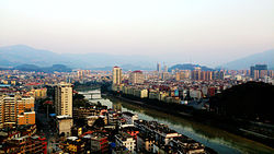
Yongchun (Chinese: 永春; pinyin: Yǒngchūn; Min Nan: Éng-chhun; lit. 'eternal spring') is a county in western Quanzhou city of southern Fujian province, People's Republic of China, located on the upper reaches of the Jin River. It is under the administration of Quanzhou City.[1] As of 2009[update], it had a total population of 558,996 residing in an area of 1,469 square kilometres (567 sq mi).[2]
Yongchun County
永春县 Yungchun | |
|---|---|
 | |
 Yongchun in Quanzhou | |
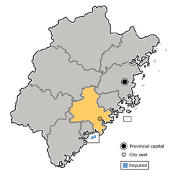 Quanzhou in Fujian | |
| Coordinates: 25°19′12″N 118°17′20″E / 25.320°N 118.289°E | |
| Country | People's Republic of China |
| Province | Fujian |
| Prefecture-level city | Quanzhou |
| County seat | Taocheng (桃城镇) |
| Area | |
| • Total | 1,469 km2 (567 sq mi) |
| Elevation | 121 m (397 ft) |
| Population (2009) | |
| • Total | 558,996 |
| • Density | 380/km2 (990/sq mi) |
| Time zone | UTC+8 (China Standard) |
| Postal code | 362600 |
| Area code | 0595 |
| Website | fjyc |
Many overseas Chinese in Southeast Asia have ancestors from Yongchun.[3]
The county's historical sites include the Dongguan Bridge, an ancient covered bridge with a number of shrines inside. Originally built in 1145 and renovated a number of times since, the bridge is located in Dongmei village of Dongguan Township, on the road from Yongchun to the neighboring Xianyou County.[4]
In 2011, the Taiwanese temple of goddess Mazu in Xingang opened a branch Mazu temple in the county, located in Chenban village. Instrumental to this foundation was Professor Chen, of the Chinese Academy of Social Sciences in Beijing, a scholar of goddess Mazu whose family lived in Chenban village, who in 2010 attended a conference in Xingang. The Xingang Mazu Temple funded the construction, and Professor Chen secured the necessary authorizations in Yongchun County to expand an existing temple to the Daoist Master Zhang Daoling by adding a Mazu Black Hall. The statue of Mazu is carried in procession through the county during the Chinese New Year holidays. The fame of the temple has helped placing Chenban village, whose name according to Professor Chen "nobody had ever heard before" on the map.[5]
Yongchun is home to a Chinese martial art called Yongchun White Crane Kung Fu. The style was founded in the 17th century and Yongchun remains its ancestral centre to this day.[6]
Administration edit

Towns (镇, zhen) edit
The county oversees 18 towns:[7]
|
|
Townships edit
There are 4 townships (乡, xiāng):[7]
- Hengkou Township (横口乡)
- Chengxiang Township (呈祥乡)
- Jiefu Township (介福乡)
- Waishan Township (外山乡)
Climate edit
| Climate data for Yongchun (1991–2020 normals, extremes 1981–2010) | |||||||||||||
|---|---|---|---|---|---|---|---|---|---|---|---|---|---|
| Month | Jan | Feb | Mar | Apr | May | Jun | Jul | Aug | Sep | Oct | Nov | Dec | Year |
| Record high °C (°F) | 29.0 (84.2) |
32.2 (90.0) |
33.2 (91.8) |
34.4 (93.9) |
36.3 (97.3) |
38.0 (100.4) |
39.6 (103.3) |
39.0 (102.2) |
37.1 (98.8) |
35.8 (96.4) |
34.9 (94.8) |
29.6 (85.3) |
39.6 (103.3) |
| Mean daily maximum °C (°F) | 18.1 (64.6) |
19.0 (66.2) |
21.3 (70.3) |
25.4 (77.7) |
28.5 (83.3) |
31.1 (88.0) |
33.8 (92.8) |
33.3 (91.9) |
31.5 (88.7) |
28.2 (82.8) |
24.4 (75.9) |
20.1 (68.2) |
26.2 (79.2) |
| Daily mean °C (°F) | 12.5 (54.5) |
13.5 (56.3) |
15.9 (60.6) |
20.1 (68.2) |
23.5 (74.3) |
26.3 (79.3) |
28.2 (82.8) |
27.7 (81.9) |
26.1 (79.0) |
22.5 (72.5) |
18.6 (65.5) |
14.2 (57.6) |
20.8 (69.4) |
| Mean daily minimum °C (°F) | 8.9 (48.0) |
10.0 (50.0) |
12.4 (54.3) |
16.5 (61.7) |
20.1 (68.2) |
23.2 (73.8) |
24.4 (75.9) |
24.2 (75.6) |
22.4 (72.3) |
18.4 (65.1) |
14.7 (58.5) |
10.3 (50.5) |
17.1 (62.8) |
| Record low °C (°F) | −0.8 (30.6) |
−0.7 (30.7) |
0.2 (32.4) |
6.3 (43.3) |
9.3 (48.7) |
14.1 (57.4) |
20.1 (68.2) |
20.4 (68.7) |
15.0 (59.0) |
6.8 (44.2) |
2.4 (36.3) |
−3.3 (26.1) |
−3.3 (26.1) |
| Average precipitation mm (inches) | 52.1 (2.05) |
75.1 (2.96) |
130.9 (5.15) |
140.9 (5.55) |
236.0 (9.29) |
287.9 (11.33) |
206.9 (8.15) |
309.3 (12.18) |
185.1 (7.29) |
56.9 (2.24) |
41.0 (1.61) |
40.0 (1.57) |
1,762.1 (69.37) |
| Average precipitation days (≥ 0.1 mm) | 8.6 | 11.6 | 15.8 | 14.9 | 17.9 | 18.2 | 13.8 | 17.8 | 11.9 | 5.7 | 6.4 | 7.2 | 149.8 |
| Average snowy days | 0.1 | 0 | 0 | 0 | 0 | 0 | 0 | 0 | 0 | 0 | 0 | 0 | 0.1 |
| Average relative humidity (%) | 73 | 76 | 78 | 77 | 80 | 83 | 78 | 80 | 76 | 72 | 72 | 71 | 76 |
| Mean monthly sunshine hours | 120.2 | 96.1 | 100.5 | 112.3 | 116.0 | 124.5 | 202.6 | 184.6 | 168.6 | 171.7 | 143.8 | 141.9 | 1,682.8 |
| Percent possible sunshine | 36 | 30 | 27 | 29 | 28 | 30 | 48 | 46 | 46 | 48 | 44 | 43 | 38 |
| Source: China Meteorological Administration[8][9] | |||||||||||||
See also edit
References edit
- ^ "Yongchun County". Archived from the original on April 12, 2011. Retrieved April 23, 2010.
- ^ "20-3 年末户籍统计人口数(2009年)". 福建统计年鉴—2010 (in Chinese). Fujian Statistics Bureau.
- ^ Rethinking Chinese transnational enterprises: cultural affinity and business - (2001) By Leo Douw, Cen Huang, David Fu-Keung Ip
- ^ CHINA’S HISTORIC BRIDGES: ARCHITECTURE OVER WATER. Fujian Province. Images by Ronald G. Knapp, Larissa L. Mentzer, and Jeffrey D. Knapp
- ^ Hsun Chang, "Multiple Religious and National Identities: Mazu Pilgrimages across the Taiwan Strait after 1987," in Cheng-tian Kuo (Ed.), Religion and Nationalism in Chinese Societies, Amsterdam: Amsterdam University Press, 2017, 373–396.
- ^ "Fujian White Crane Kung Fu".
- ^ a b 2011年统计用区划代码和城乡划分代码:永春县 (in Chinese). National Bureau of Statistics of the People's Republic of China. Retrieved 2012-12-30.
- ^ 中国气象数据网 – WeatherBk Data (in Simplified Chinese). China Meteorological Administration. Retrieved 23 June 2023.
- ^ 中国气象数据网 (in Simplified Chinese). China Meteorological Administration. Retrieved 23 June 2023.
External links edit
- Official website