


Summary
Guimaras Strait is a strait in the Western Visayas region of the Philippines, connecting the Visayan Sea with Panay Gulf and the Sulu Sea beyond. To the north and west are Panay and Guimaras Islands, while Negros Island is to the south and east.[1] Bacolod City is a major seaport on the strait, which also provides access to the Port of Iloilo City via the Iloilo Strait.
| Guimaras Strait | |
|---|---|
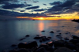 Guimaras Strait at Bacolod | |
 Guimaras Strait Location within the Philippines | |
 | |
| Location | Western Visayas |
| Coordinates | 10°42′N 122°49′E / 10.700°N 122.817°E |
| Type | strait |
| Basin countries | Philippines |
| Max. length | 95 km (59 mi), N-S |
| Islands | Guimaras, Pan de Azucar |
| Settlements | Bacolod |
Marine species
editThe Guimaras Strait is an important fishing ground in the Philippines, having an average of annual fish production of 50,000 metric tons. The northern part is particularly known for blue crab, a top export commodity.
Other species present in the strait include barracuda, cavalla, clams, cockles, crevalle, dolphin, flounders, flying fish, fusiliers, glassfish, goatfish, goby, grouper, jacks, jelly fish, lizard fish, marine turtle, milkfish, mojarra, moonfish, moray, mullets, mussels, scallops, oysters, perchlet, scads, sea bass, sea catfish, sea cucumber, sea perches, sea urchins, seaweeds, shads, sicklefish, siganids, sillago, slipmouth, snappers, spadefish, sponges, surgeon fish, threadfin, and wrasses.[2][3]
Environmental issues
editThe Guimaras oil spill, that occurred in Panay Gulf on August 11, 2006, has severely affected the fishing industry. During this spill, considered Philippines' worst, the oil tanker M/T Solar 1 sank during a violent storm, spilling some 500,000 litres (110,000 imp gal; 130,000 US gal) of oil which formed an oil slick that drifted through the strait.[4] This spill followed another one in December 2005, when a passenger ship ran aground in the strait. It spilled 360,000 litres (79,000 imp gal; 95,000 US gal) of fuel oil, polluting some 40 kilometres (25 mi) of coastline and 230 hectares (570 acres) of virgin mangrove forests.[5]
Besides these oil spills, the ecosystems of the Guimaras Strait also suffer from rapid coastal development and overfishing. Increased urban populations and transportation are causing anthropogenic pressures,[6] while gillnet fishing has exceeded the maximum sustainable yield since 1999.[7]
References
edit- ^ "Quick Facts". Province of Guimaras. Archived from the original on 18 August 2013. Retrieved 17 July 2013.
- ^ Melchor F. Cichon (13 September 2006). "Guimaras Strait: Focusing on Fish Production". Fisheries Librarian. Retrieved 15 July 2013.
- ^ "Community-Based Resource Management and Food Security of the Northern Guimaras Strait". WWF Philippines. 7 July 2008. Archived from the original on 6 March 2010. Retrieved 15 July 2013.
- ^ Sarah Toms (15 August 2006). "Oil spill threatens Philippines". BBC News. Retrieved 15 July 2013.
- ^ "The PALSAR image of the heavy oil spill area, caused by a sunken tanker on August11, off Negros Island of the Philippines, in the Guimaras Strait (Observed on August 25)" (PDF). PALSAR Project. ERSDAC. September 1, 2006. Archived from the original (PDF) on 26 October 2015. Retrieved 17 July 2013.
- ^ "Guimaras Strait and surrounding coastal zone, Western Visayas PHILIPPINES". Study Sites. CECAM Project. Retrieved 17 July 2013.
- ^ "Philippine Blue Swimming Crab Fishery Improvement Project". Sustainable Fisheries Partnership. April 2013. Retrieved 17 July 2013.