


Summary
The Iberian Peninsula (/aɪˈbɪəriən/),[a] also known as Iberia,[b] is a peninsula in South-western Europe, defining the westernmost edge of Eurasia. It is divided between Continental Portugal and Peninsular Spain, comprising most of the region, as well as Andorra, Gibraltar, and a small part of Southern France (French Cerdagne). With an area of approximately 583,254 square kilometres (225,196 sq mi),[1] and a population of roughly 53 million,[2] it is the second-largest European peninsula by area, after the Scandinavian Peninsula.
Native names
| |
|---|---|
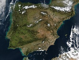 Satellite image of the Iberian Peninsula | |
 | |
| Geography | |
| Location | Europe |
| Coordinates | 40°30′N 4°00′W / 40.500°N 4.000°W |
| Area | 583,254 km2 (225,196 sq mi) |
| Highest elevation | 3,478 m (11411 ft) |
| Highest point | Mulhacén |
| Administration | |
| Demographics | |
| Demonym | Iberian |
| Population | c. 53 million |
Name edit

Greek name edit
The word Iberia is a noun adapted from the Latin word "Hiberia" originating in the Ancient Greek word Ἰβηρία (Ibēríā), used by Greek geographers under the rule of the Roman Empire to refer to what is known today in English as the Iberian Peninsula.[3] At that time, the name did not describe a single geographical entity or a distinct population; the same name was used for the Kingdom of Iberia, natively known as Kartli in the Caucasus, the core region of what would later become the Kingdom of Georgia.[4] It was Strabo who first reported the delineation of "Iberia" from Gaul (Keltikē) by the Pyrenees[5] and included the entire land mass southwest (he says "west") from there.[6] With the fall of the Western Roman Empire and the consolidation of romanic languages, the word "Iberia" continued the Roman word "Hiberia" and the Greek word "Ἰβηρία".
The ancient Greeks reached the Iberian Peninsula, of which they had heard from the Phoenicians, by voyaging westward on the Mediterranean.[7] Hecataeus of Miletus was the first known to use the term Iberia, which he wrote about c. 500 BCE.[8] Herodotus of Halicarnassus says of the Phocaeans that "it was they who made the Greeks acquainted with [...] Iberia."[9] According to Strabo,[10] prior historians used Iberia to mean the country "this side of the Ἶβηρος" (Ibēros, the Ebro) as far north as the Rhône, but in his day they set the Pyrenees as the limit. Polybius respects that limit,[11] but identifies Iberia as the Mediterranean side as far south as Gibraltar, with the Atlantic side having no name. Elsewhere[12] he says that Saguntum is "on the seaward foot of the range of hills connecting Iberia and Celtiberia."
Roman names edit
According to Charles Ebel, the ancient sources in both Latin and Greek use Hispania and Hiberia (Greek: Iberia) as synonyms. The confusion of the words was because of an overlapping in political and geographic perspectives. The Latin word Hiberia, similar to the Greek Iberia, literally translates to "land of the Hiberians". This word was derived from the river Hiberus (now called Ebro or Ebre). Hiber (Iberian) was thus used as a term for peoples living near the river Ebro.[5][13] The first mention in Roman literature was by the annalist poet Ennius in 200 BCE.[14][15][16] Virgil wrote impacatos (H)iberos ("restless Iberi") in his Georgics.[17] The Roman geographers and other prose writers from the time of the late Roman Republic called the entire peninsula Hispania.
In Greek and Roman antiquity, the name Hesperia was used for both the Italian and Iberian Peninsula; in the latter case Hesperia Ultima (referring to its position in the far west) appears as form of disambiguation from the former among Roman writers.[18] Also since Roman antiquity, Jews gave the name Sepharad to the peninsula.[19]
As they became politically interested in the former Carthaginian territories, the Romans began to use the names Hispania Citerior and Hispania Ulterior for 'near' and 'far' Hispania. At the time Hispania was made up of three Roman provinces: Hispania Baetica, Hispania Tarraconensis, and Hispania Lusitania. Strabo says[10] that the Romans use Hispania and Iberia synonymously, distinguishing between the near northern and the far southern provinces. (The name Iberia was ambiguous, being also the name of the Kingdom of Iberia in the Caucasus.)
Whatever languages may generally have been spoken on the peninsula soon gave way to Latin, except for that of the Vascones, which was preserved as a language isolate by the barrier of the Pyrenees.
Modern name edit
The modern phrase "Iberian Peninsula" was coined by the French geographer Jean-Baptiste Bory de Saint-Vincent on his 1823 work "Guide du Voyageur en Espagne". Prior to that date, geographers had used the terms 'Spanish Peninsula' or 'Pyrenaean Peninsula'.[20]
Etymology edit

The Iberian Peninsula has always been associated with the River Ebro (Ibēros in ancient Greek and Ibērus or Hibērus in Latin). The association was so well known it was hardly necessary to state; for example, Ibēria was the country "this side of the Ibērus" in Strabo. Pliny goes so far as to assert that the Greeks had called "the whole of Spain" Hiberia because of the Hiberus River.[21] The river appears in the Ebro Treaty of 226 BCE between Rome and Carthage, setting the limit of Carthaginian interest at the Ebro. The fullest description of the treaty, stated in Appian,[22] uses Ibērus. With reference to this border, Polybius[23] states that the "native name" is Ibēr, apparently the original word, stripped of its Greek or Latin -os or -us termination.
The early range of these natives, which geographers and historians place from the present southern Spain to the present southern France along the Mediterranean coast, is marked by instances of a readable script expressing a yet unknown language, dubbed "Iberian". Whether this was the native name or was given to them by the Greeks for their residence near the Ebro remains unknown. Credence in Polybius imposes certain limitations on etymologizing: if the language remains unknown, the meanings of the words, including Iber, must also remain unknown. In modern Basque, the word ibar[24] means "valley" or "watered meadow", while ibai[24] means "river", but there is no proof relating the etymology of the Ebro River with these Basque names.
Prehistory edit
Palaeolithic edit
The Iberian Peninsula has been inhabited by members of the Homo genus for at least 1.2 million years as remains found in the sites in the Atapuerca Mountains demonstrate. Among these sites is the cave of Gran Dolina, where six hominin skeletons, dated between 780,000 and one million years ago, were found in 1994. Experts have debated whether these skeletons belong to the species Homo erectus, Homo heidelbergensis, or a new species called Homo antecessor. According to other authors, the archaeo-palaeontological records in Sierra de Atapuerca, inside the caves and in the open-air sites, have confirmed a continuous settlement from the Lower Pleistocene (Lower Paleolithic) to the Holocene (Bronze Age), with several species of hominids (Homo antecessor, Homo heidelbergensis, Homo neanderthalensis and Homo sapiens) exploiting the same territory. [25][26][27] According to these authors, in the surroundings of Sierra de Atapuerca, the archaeological consequence of the continuous territorial occupation of the same area from 1.3 Ma to the Bronze Age (2100-850 cal. BC) has been the deposition of hundreds of open-air sites, with campsites, flintknapping workshops and other sites with complementary economic activities.[25][26][27]
In the Iberian Peninsula Oldowan stone tools (Mode 1) have been found at the following sites (caves and open-air sites): Fuente Nueva 3 (Orce, Granada), Barranco León (Orce, Granada), Sima del Elefante (Sierra de Atapuerca, Burgos), Gran Dolina TD6 (Sierra de Atapuerca, Burgos) and in other open-air sites.[25] The archaeo-palaeontological records in Sierra de Atapuerca (Burgos, Spain) from Lower Paleolithic have provided Oldowan stone tools associated with Homo antecessor (Gran Dolina site, TD6 level, ca. 800,000 years BP)[25]
Acheulean stone tools (Mode 2) have been found in the Middle Pleistocene caves and in open-air sites of the main valleys (i.e., Quaternary terraces of the rivers Ebro, Duero, Arlanzón, Arlanza, Pisuerga, Miño, Tormes, Tajo, Guadiana, Guadalquivir, etc.)[25] The archaeo-palaeontological records in Sierra de Atapuerca (Burgos, Spain) from Lower Paleolithic have provided Acheulean tools associated with Homo heidelbergensis (ca. 450,000 years BP)[25]
Mousterian stone tools (Mode 3) have been found in the Middle and Upper Pleistocene caves and in open-air sites of the main valleys.[25] The archaeo-palaeontological records in the Sierra de Atapuerca caves (Burgos, Spain) from Middle Paleolithic (i.e., Galería de las Estatuas y Cueva Fantasma sites) have provided Mousterian stone tools associated with Homo neanderthalensis (ca. 250,000 to 30,000 years BP).[25]
Around 200,000 BP, during the Lower Paleolithic period, Neanderthals first entered the Iberian Peninsula. Around 70,000 BP, during the Middle Paleolithic period, the last glacial event began and the Neanderthal Mousterian culture was established. Around 37,000 BP, during the Upper Paleolithic, the Neanderthal Châtelperronian cultural period began. Emanating from Southern France, this culture extended into the north of the peninsula. It continued to exist until around 30,000 BP, when Neanderthal man faced extinction.
About 40,000 years ago, anatomically modern humans entered the Iberian Peninsula from across the Pyrenees.[28] Haplogroup R1b is common in modern Portuguese and Spanish males. On the Iberian Peninsula, modern humans developed a series of different cultures, such as the Aurignacian, Gravettian, Solutrean and Magdalenian cultures, some of them characterized by the complex forms of the art of the Upper Paleolithic.
Neolithic edit
The Iberian Epipaleolithic, —also described as Mesolithic—, is divided into three stages from 9300 cal. BC to 5200 cal BC. The Neolithic began on the Iberian Peninsula in 5700/5600 cal. BC according to several sites in the Levant area of the Peninsula. On the Northern Iberian Plateau is present in the karst records and the open air sites from the last third of the VI millennium cal. BC. [25][26][27]
During the Neolithic expansion, various megalithic cultures developed in the Iberian Peninsula.[29] An open seas navigation culture from the east Mediterranean, called the Cardium culture, also extended its influence to the eastern coasts of the peninsula, possibly as early as the 5th millennium BCE. These people may have had some relation to the subsequent development of the Iberian civilization.
As is the case for most of the rest of Southern Europe, the principal ancestral origin of modern Iberians are Early European Farmers who arrived during the Neolithic. The large predominance of Y-Chromosome Haplogroup R1b, common throughout Western Europe, is testimony to a considerable input from various waves of (predominantly male) Western Steppe Herders from the Pontic–Caspian steppe during the Bronze Age. Iberia experienced a significant genetic turnover, with 100% of the paternal ancestry and 40% of the overall ancestry being replaced by peoples with steppe-related ancestry.[30]
Chalcolithic edit

In the Chalcolithic (c. 3000 BCE), a series of complex cultures developed that would give rise to the peninsula's first civilizations and to extensive exchange networks reaching to the Baltic, Middle East and North Africa. Around 2800 – 2700 BCE, the Beaker culture, which produced the Maritime Bell Beaker, probably originated in the vibrant copper-using communities of the Tagus estuary and spread from there to many parts of western Europe.[31]
According to radiocarbon datings, the Pre-Bell Beaker Chalcolithic began on the Northern Iberian Plateau in 3000 cal. BC and the Bell Beaker Chalcolithic appeared around 2500 cal. BC.[25][26][27]
Bronze Age edit
The Bronze Age began on the Iberian Peninsula in 2100 cal. BC according to radiocarbon datings of several key sites. According to the period sequence,[25][26][27] the Iberian Bronze Age is divided into three sub-periods or phases with different diagnostic markers (lithic tools, decorated ceramics and types of metal tools): Early Bronze Age, Middle Bronze Age and Late Bronze Age. The Early Bronze Age began on the Northern Iberian Plateau in 2100 cal. BC and the Late Bronze Age in 1350 cal. BC. In the three phases of the Iberian Bronze Age, different cultures emerged, which have been defined by regions with typical names: e.g. El Argar, Las Motillas, Bronce Atlántico, Bronce Valenciano, Montelavar, Las Cogotas and others.[25][26]
Bronze Age cultures developed beginning c. 1800 BCE,[32] when the culture of Los Millares was followed by that of El Argar.[33][34] During the Early Bronze Age, southeastern Iberia saw the emergence of important settlements, a development that has compelled some archeologists to propose that these settlements indicate the advent of state-level social structures.[35] From this centre, bronze metalworking technology spread to other cultures like the Bronze of Levante, South-Western Iberian Bronze and Las Cogotas.
Preceded by the Chalcolithic sites of Los Millares, the Argaric culture flourished in southeastern Iberia in from 2200 BC to 1550 BC,[36] when depopulation of the area ensued along with disappearing of copper–bronze–arsenic metallurgy.[37] The most accepted model for El Argar has been that of an early state society, most particularly in terms of class division, exploitation, and coercion,[38] with agricultural production, maybe also human labour, controlled by the larger hilltop settlements,[39] and the elite using violence in practical and ideological terms to clamp down on the population.[40] Ecological degradation, landscape opening, fires, pastoralism, and maybe tree cutting for mining have been suggested as reasons for the collapse.[41]
The culture of the motillas developed an early system of groundwater supply plants (the so-called motillas) in the upper Guadiana basin (in the southern meseta) in a context of extreme aridification in the area in the wake of the 4.2-kiloyear climatic event, which roughly coincided with the transition from the Copper Age to the Bronze Age. Increased precipitation and recovery of the water table from about 1800 BC onward should have led to the forsaking of the motillas (which may have flooded) and the redefinition of the relation of the inhabitants of the territory with the environment.[42]
Proto-history edit

According to radiocarbon datings, the Iron Age began on the Iberian Peninsula in 850/800 cal. BC with the arrival of the Phoenicians, while on the Northern Iberian Plateau it will arrive a little later, in 800-750 cal. BC.[25][26]
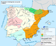
By the Iron Age, starting in the 8th century BCE, the Iberian Peninsula consisted of complex agrarian and urban civilizations, either Pre-Celtic or Celtic (such as the Celtiberians, Gallaeci, Astures, Celtici, Lusitanians and others), the cultures of the Iberians in the eastern and southern zones and the cultures of the Aquitanian in the western portion of the Pyrenees.
As early as the 12th century BCE, the Phoenicians, a thalassocratic civilization originally from the Eastern Mediterranean, began to explore the coastline of the peninsula, interacting with the metal-rich communities in the southwest of the peninsula (contemporarily known as the semi-mythical Tartessos).[44] Around 1100 BCE, Phoenician merchants founded the trading colony of Gadir or Gades (modern day Cádiz). Phoenicians established a permanent trading port in the Gadir colony c. 800 BCE in response to the increasing demand of silver from the Assyrian Empire.[45]
The seafaring Phoenicians, Greeks and Carthaginians successively settled along the Mediterranean coast and founded trading colonies there over several centuries. In the 8th century BCE, the first Greek colonies, such as Emporion (modern Empúries), were founded along the Mediterranean coast on the east, leaving the south coast to the Phoenicians.
Together with the presence of Phoenician and Greek epigraphy, several paleohispanic scripts developed in the Iberian Peninsula along the 1st millennium BCE. The development of a primordial paleohispanic script antecessor to the rest of paleohispanic scripts (originally supposed to be a non-redundant semi-syllabary) derived from the Phoenician alphabet and originated in Southwestern Iberia by the 7th century BCE has been tentatively proposed.[46]
In the sixth century BCE, the Carthaginians arrived in the peninsula while struggling with the Greeks for control of the Western Mediterranean. Their most important colony was Carthago Nova (modern-day Cartagena, Spain).
History edit
Roman rule edit
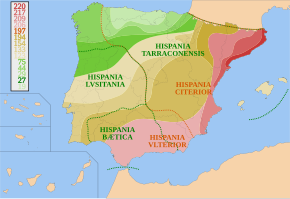
In 218 BCE, during the Second Punic War against the Carthaginians, the first Roman troops occupied the Iberian Peninsula, known to them as Hispania. After 197, the territories of the peninsula most accustomed to external contact and with the most urban tradition (the Mediterranean Coast and the Guadalquivir Valley) were divided by Romans into Hispania Ulterior and Hispania Citerior.[47] Local rebellions were quelled, with a 195 Roman campaign under Cato the Elder ravaging hotspots of resistance in the northeastern Ebro Valley and beyond.[48] The threat to Roman interests posed by Celtiberians and Lusitanians in uncontrolled territories lingered in.[49] Further wars of indigenous resistance, such as the Celtiberian Wars and the Lusitanian War, were fought in the 2nd century. Urban growth took place, and population progressively moved from hillforts to the plains.[50]
An example of the interaction of slaving and ecocide, the aftermath of the conquest increased mining extractive processes in the southwest of the peninsula (which required a massive number of forced laborers, initially from Hispania and latter also from the Gallic borderlands and other locations of the Mediterranean), bringing in a far-reaching environmental outcome vis-à-vis long-term global pollution records, with levels of atmospheric pollution from mining across the Mediterranean during Classical Antiquity having no match until the Industrial Revolution.[51][52]
In addition to mineral extraction (of which the region was the leading supplier in the early Roman world, with production of the likes of gold, silver, copper, lead, and cinnabar), Hispania also produced manufactured goods (sigillata pottery, colourless glass, linen garments) fish and fish sauce (garum), dry crops (such as wheat and, more importantly, esparto), olive oil, and wine.[53]
The process of Romanization spurred on throughout the first century BC.[54] The peninsula was also the battleground of civil wars between rulers of the Roman republic, such as the Sertorian War or the conflict between Caesar and Pompey later in the century.[55]
During their 600-year occupation of the Iberian Peninsula, the Romans introduced the Latin language that influenced many of the languages that exist today in the Iberian peninsula.
Pre-modern Iberia edit

In the early fifth century, Germanic peoples occupied the peninsula, namely the Suebi, the Vandals (Silingi and Hasdingi) and their allies, the Alans. Only the kingdom of the Suebi (Quadi and Marcomanni) would endure after the arrival of another wave of Germanic invaders, the Visigoths, who occupied all of the Iberian Peninsula and expelled or partially integrated the Vandals and the Alans. The Visigoths eventually occupied the Suebi kingdom and its capital city, Bracara (modern day Braga), in 584–585. They would also occupy the province of the Byzantine Empire (552–624) of Spania in the south of the peninsula[citation needed]. However, Balearic Islands remained in Byzantine hands until Umayyad conquest, which began in 703 CE and was completed in 902 CE.[56][57]
In 711, a Muslim army conquered the Visigothic Kingdom in Hispania. Under Tariq ibn Ziyad, the Islamic army landed at Gibraltar and, in an eight-year campaign, occupied all except the northern kingdoms of the Iberian Peninsula in the Umayyad conquest of Hispania. Al-Andalus (Arabic: الإندلس, tr. al-ʾAndalūs, possibly "Land of the Vandals"),[58][59] is the Arabic name given to Muslim Iberia. The Muslim conquerors were Arabs and Berbers; following the conquest, conversion and arabization of the Hispano-Roman population took place, [60] (muwalladum or Muladí).[61][62] After a long process, spurred on in the 9th and 10th centuries, the majority of the population in Al-Andalus eventually converted to Islam.[63] The Muslims were referred to by the generic name Moors.[64] The Muslim population was divided per ethnicity (Arabs, Berbers, Muladí), and the supremacy of Arabs over the rest of group was a recurrent causal for strife, rivalry and hatred, particularly between Arabs and Berbers.[65] Arab elites could be further divided in the Yemenites (first wave) and the Syrians (second wave).[66] Christians and Jews were allowed to live as part of a stratified society under the dhimmah system,[67] although Jews became very important in certain fields.[68] Some Christians migrated to the Northern Christian kingdoms, while those who stayed in Al-Andalus progressively arabised and became known as musta'arab (mozarabs).[69] The slave population comprised the Ṣaqāliba (literally meaning "slavs", although they were slaves of generic European origin) as well as Sudanese slaves.[70]
The Umayyad rulers faced a major Berber Revolt in the early 740s; the uprising originally broke out in North Africa (Tangier) and later spread across the peninsula.[71] Following the Abbasid takeover from the Umayyads and the shift of the economic centre of the Islamic Caliphate from Damascus to Baghdad, the western province of al-Andalus was marginalised and ultimately became politically autonomous as independent emirate in 756, ruled by one of the last surviving Umayyad royals, Abd al-Rahman I.[72]

Al-Andalus became a center of culture and learning, especially during the Caliphate of Córdoba. The Caliphate reached the height of its power under the rule of Abd-ar-Rahman III and his successor al-Hakam II, becoming then, in the view of Jaime Vicens Vives, "the most powerful state in Europe".[73] Abd-ar-Rahman III also managed to expand the clout of Al-Andalus across the Strait of Gibraltar,[73] waging war, as well as his successor, against the Fatimid Empire.[74]
Between the 8th and 12th centuries, Al-Andalus enjoyed a notable urban vitality, both in terms of the growth of the preexisting cities as well as in terms of founding of new ones: Córdoba reached a population of 100,000 by the 10th century, Toledo 30,000 by the 11th century and Seville 80,000 by the 12th century.[75]
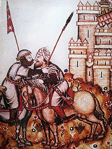
During the Middle Ages, the North of the peninsula housed many small Christian polities including the Kingdom of Castile, the Kingdom of Aragon, the Kingdom of Navarre, the Kingdom of León or the Kingdom of Portugal, as well as a number of counties that spawned from the Carolingian Marca Hispanica. Christian and Muslim polities fought and allied among themselves in variable alliances.[c] The Christian kingdoms progressively expanded south taking over Muslim territory in what is historiographically known as the "Reconquista" (the latter concept has been however noted as product of the claim to a pre-existing Spanish Catholic nation and it would not necessarily convey adequately "the complexity of centuries of warring and other more peaceable interactions between Muslim and Christian kingdoms in medieval Iberia between 711 and 1492").[77]
The Caliphate of Córdoba was subsumed in a period of upheaval and civil war (the Fitna of al-Andalus) and collapsed in the early 11th century, spawning a series of ephemeral statelets, the taifas. Until the mid 11th century, most of the territorial expansion southwards of the Kingdom of Asturias/León was carried out through a policy of agricultural colonization rather than through military operations; then, profiting from the feebleness of the taifa principalities, Ferdinand I of León seized Lamego and Viseu (1057–1058) and Coimbra (1064) away from the Taifa of Badajoz (at times at war with the Taifa of Seville);[78][79] Meanwhile, in the same year Coimbra was conquered, in the Northeastern part of the Iberian Peninsula, the Kingdom of Aragon took Barbastro from the Hudid Taifa of Lérida as part of an international expedition sanctioned by Pope Alexander II. Most critically, Alfonso VI of León-Castile conquered Toledo and its wider taifa in 1085, in what it was seen as a critical event at the time, entailing also a huge territorial expansion, advancing from the Sistema Central to La Mancha.[80] In 1086, following the siege of Zaragoza by Alfonso VI of León-Castile, the Almoravids, religious zealots originally from the deserts of the Maghreb, landed in the Iberian Peninsula, and, having inflicted a serious defeat to Alfonso VI at the battle of Zalaca, began to seize control of the remaining taifas.[81]
The Almoravids in the Iberian peninsula progressively relaxed strict observance of their faith, and treated both Jews and Mozarabs harshly, facing uprisings across the peninsula, initially in the Western part.[82] The Almohads, another North-African Muslim sect of Masmuda Berber origin who had previously undermined the Almoravid rule south of the Strait of Gibraltar,[83] first entered the peninsula in 1146.[84]
Somewhat straying from the trend taking place in other locations of the Latin West since the 10th century, the period comprising the 11th and 13th centuries was not one of weakening monarchical power in the Christian kingdoms.[85] The relatively novel concept of "frontier" (Sp: frontera), already reported in Aragon by the second half of the 11th century become widespread in the Christian Iberian kingdoms by the beginning of the 13th century, in relation to the more or less conflictual border with Muslim lands.[86]
By the beginning of the 13th century, a power reorientation took place in the Iberian Peninsula (parallel to the Christian expansion in Southern Iberia and the increasing commercial impetus of Christian powers across the Mediterranean) and to a large extent, trade-wise, the Iberian Peninsula reorientated towards the North away from the Muslim World.[87]
During the Middle Ages, the monarchs of Castile and León, from Alfonso V and Alfonso VI (crowned Hispaniae Imperator) to Alfonso X and Alfonso XI tended to embrace an imperial ideal based on a dual Christian and Jewish ideology.[88] Despite the hegemonic ambitions of its rulers and the consolidation of the union of Castile and León after 1230, it should be pointed that, except for a brief period in the 1330s and 1340s, Castile tended to be nonetheless "essentially unstable" from a political standpoint until the late 15th century.[89]
Merchants from Genoa and Pisa were conducting an intense trading activity in Catalonia already by the 12th century, and later in Portugal.[90] Since the 13th century, the Crown of Aragon expanded overseas; led by Catalans, it attained an overseas empire in the Western Mediterranean, with a presence in Mediterranean islands such as the Balearics, Sicily and Sardinia, and even conquering Naples in the mid-15th century.[91] Genoese merchants invested heavily in the Iberian commercial enterprise with Lisbon becoming, according to Virgínia Rau, the "great centre of Genoese trade" in the early 14th century.[92] The Portuguese would later detach their trade to some extent from Genoese influence.[90] The Nasrid Kingdom of Granada, neighbouring the Strait of Gibraltar and founded upon a vassalage relationship with the Crown of Castile,[93] also insinuated itself into the European mercantile network, with its ports fostering intense trading relations with the Genoese as well, but also with the Catalans, and to a lesser extent, with the Venetians, the Florentines, and the Portuguese.[94]
Between 1275 and 1340, Granada became involved in the "crisis of the Strait", and was caught in a complex geopolitical struggle ("a kaleidoscope of alliances") with multiple powers vying for dominance of the Western Mediterranean, complicated by the unstable relations of Muslim Granada with the Marinid Sultanate.[95] The conflict reached a climax in the 1340 Battle of Río Salado, when, this time in alliance with Granada, the Marinid Sultan (and Caliph pretender) Abu al-Hasan Ali ibn Othman made the last Marinid attempt to set up a power base in the Iberian Peninsula. The lasting consequences of the resounding Muslim defeat to an alliance of Castile and Portugal with naval support from Aragon and Genoa ensured Christian supremacy over the Iberian Peninsula and the preeminence of Christian fleets in the Western Mediterranean.[96]

The 1348–1350 bubonic plague devastated large parts of the Iberian Peninsula, leading to a sudden economic cessation.[97] Many settlements in northern Castile and Catalonia were left forsaken.[97] The plague marked the start of the hostility and downright violence towards religious minorities (particularly the Jews) as an additional consequence in the Iberian realms.[98]
The 14th century was a period of great upheaval in the Iberian realms. After the death of Peter the Cruel of Castile (reigned 1350–69), the House of Trastámara succeeded to the throne in the person of Peter's half brother, Henry II (reigned 1369–79). In the kingdom of Aragón, following the death without heirs of John I (reigned 1387–96) and Martin I (reigned 1396–1410), a prince of the House of Trastámara, Ferdinand I (reigned 1412–16), succeeded to the Aragonese throne.[99] The Hundred Years' War also spilled over into the Iberian peninsula, with Castile particularly taking a role in the conflict by providing key naval support to France that helped lead to that nation's eventual victory.[100] After the accession of Henry III to the throne of Castile, the populace, exasperated by the preponderance of Jewish influence, perpetrated a massacre of Jews at Toledo. In 1391, mobs went from town to town throughout Castile and Aragon, killing an estimated 50,000 Jews,[101][102][103][104][105] or even as many as 100,000, according to Jane Gerber.[106] Women and children were sold as slaves to Muslims, and many synagogues were converted into churches. According to Hasdai Crescas, about 70 Jewish communities were destroyed.[107]
During the 15th century, Portugal, which had ended its southwards territorial expansion across the Iberian Peninsula in 1249 with the conquest of the Algarve, initiated an overseas expansion in parallel to the rise of the House of Aviz, conquering Ceuta (1415) arriving at Porto Santo (1418), Madeira and the Azores, as well as establishing additional outposts along the North-African Atlantic coast.[108] In addition, already in the Early Modern Period, between the completion of the Granada War in 1492 and the death of Ferdinand of Aragon in 1516, the Hispanic Monarchy would make strides in the imperial expansion along the Mediterranean coast of the Maghreb.[109] During the Late Middle Ages, the Jews acquired considerable power and influence in Castile and Aragon.[110]
Throughout the late Middle Ages, the Crown of Aragon took part in the mediterranean slave trade, with Barcelona (already in the 14th century), Valencia (particularly in the 15th century) and, to a lesser extent, Palma de Mallorca (since the 13th century), becoming dynamic centres in this regard, involving chiefly eastern and Muslim peoples.[111] Castile engaged later in this economic activity, rather by adhering to the incipient atlantic slave trade involving sub-saharan people thrusted by Portugal (Lisbon being the largest slave centre in Western Europe) since the mid 15th century, with Seville becoming another key hub for the slave trade.[111] Following the advance in the conquest of the Nasrid kingdom of Granada, the seizure of Málaga entailed the addition of another notable slave centre for the Crown of Castile.[112]
By the end of the 15th century (1490) the Iberian kingdoms (including here the Balearic Islands) had an estimated population of 6.525 million (Crown of Castile, 4.3 million; Portugal, 1.0 million; Principality of Catalonia, 0.3 million; Kingdom of Valencia, 0.255 million; Kingdom of Granada, 0.25 million; Kingdom of Aragon, 0.25 million; Kingdom of Navarre, 0.12 million and the Kingdom of Mallorca, 0.05 million).[113]
For three decades in the 15th century, the Hermandad de las Marismas, the trading association formed by the ports of Castile along the Cantabrian coast, resembling in some ways the Hanseatic League, fought against the latter,[citation needed] an ally of England, a rival of Castile in political and economic terms.[114] Castile sought to claim the Gulf of Biscay as its own.[115] In 1419, the powerful Castilian navy thoroughly defeated a Hanseatic fleet in La Rochelle.[100][115]
In the late 15th century, the imperial ambition of the Iberian powers was pushed to new heights by the Catholic Monarchs in Castile and Aragon, and by Manuel I in Portugal.[88]

The last Muslim stronghold, Granada, was conquered by a combined Castilian and Aragonese force in 1492. As many as 100,000 Moors died or were enslaved in the military campaign, while 200,000 fled to North Africa.[116] Muslims and Jews throughout the period were variously tolerated or shown intolerance in different Christian kingdoms. After the fall of Granada, all Muslims and Jews were ordered to convert to Christianity or face expulsion—as many as 200,000 Jews were expelled from Spain.[117][118][119][120] Approximately 3,000,000 Muslims fled or were driven out of Spain between 1492 and 1610.[121] Historian Henry Kamen estimates that some 25,000 Jews died en route from Spain.[122] The Jews were also expelled from Sicily and Sardinia, which were under Aragonese rule, and an estimated 37,000 to 100,000 Jews left.[123]
In 1497, King Manuel I of Portugal forced all Jews in his kingdom to convert or leave. That same year he expelled all Muslims that were not slaves,[124] and in 1502 the Catholic Monarchs followed suit, imposing the choice of conversion to Christianity or exile and loss of property. Many Jews and Muslims fled to North Africa and the Ottoman Empire, while others publicly converted to Christianity and became known respectively as Marranos and Moriscos (after the old term Moors).[125] However, many of these continued to practice their religion in secret. The Moriscos revolted several times and were ultimately forcibly expelled from Spain in the early 17th century. From 1609 to 1614, over 300,000 Moriscos were sent on ships to North Africa and other locations, and, of this figure, around 50,000 died resisting the expulsion, and 60,000 died on the journey.[126][127]
A series of case studies by the Belfer Center for Science and International Affairs at Harvard University demonstrated that the change of relative supremacy from Portugal to the Hispanic Monarchy in the late 15th century was one of the few cases of avoidance of the Thucydides Trap.[128]
Modern Iberia edit

Challenging the conventions about the advent of modernity, Immanuel Wallerstein pushed back the origins of the capitalist modernity to the Iberian expansion of the 15th century.[129] During the 16th century Spain created a vast empire in the Americas, with a state monopoly in Seville becoming the center of the ensuing transatlantic trade, based on bullion.[130] Iberian imperialism, starting by the Portuguese establishment of routes to Asia and the posterior transatlantic trade with the New World by Spaniards and Portuguese (along Dutch, English and French), precipitated the economic decline of the Italian Peninsula.[131] The 16th century was one of population growth with increased pressure over resources;[132] in the case of the Iberian Peninsula a part of the population moved to the Americas meanwhile Jews and Moriscos were banished, relocating to other places in the Mediterranean Basin.[133] Most of the Moriscos remained in Spain after the Morisco revolt in Las Alpujarras during the mid-16th century, but roughly 300,000 of them were expelled from the country in 1609–1614, and emigrated en masse to North Africa.[134]

In 1580, after the political crisis that followed the 1578 death of King Sebastian, Portugal became a dynastic composite entity of the Hapsburg Monarchy; thus, the whole peninsula was united politically during the period known as the Iberian Union (1580–1640). During the reign of Philip II of Spain (I of Portugal), the Councils of Portugal, Italy, Flanders and Burgundy were added to the group of counselling institutions of the Hispanic Monarchy, to which the Councils of Castile, Aragon, Indies, Chamber of Castile, Inquisition, Orders, and Crusade already belonged, defining the organization of the Royal court that underpinned the Polysynodial System through which the empire operated.[136] During the Iberian union, the "first great wave" of the transatlantic slave trade happened, according to Enriqueta Vila Villar, as new markets opened because of the unification gave thrust to the slave trade.[137]
By 1600, the percentage of urban population for Spain was roughly 11.4%, while for Portugal the urban population was estimated as 14.1%, which were both above the 7.6% European average of the time (edged only by the Low Countries and the Italian Peninsula).[138] Some striking differences appeared among the different Iberian realms. Castile, extending across a 60% of the territory of the peninsula and having 80% of the population was a rather urbanised country, yet with a widespread distribution of cities.[139] Meanwhile, the urban population in the Crown of Aragon was highly concentrated in a handful of cities: Zaragoza (Kingdom of Aragon), Barcelona (Principality of Catalonia), and, to a lesser extent in the Kingdom of Valencia, in Valencia, Alicante and Orihuela.[139] The case of Portugal presented an hypertrophied capital, Lisbon (which greatly increased its population during the 16th century, from 56,000 to 60,000 inhabitants by 1527, to roughly 120,000 by the third quarter of the century) with its demographic dynamism stimulated by the Asian trade,[140] followed at great distance by Porto and Évora (both roughly accounting for 12,500 inhabitants).[141] Throughout most of the 16th century, both Lisbon and Seville were among the Western Europe's largest and most dynamic cities.[142]
The 17th century has been largely considered as a very negative period for the Iberian economies, seen as a time of recession, crisis or even decline,[143] the urban dynamism chiefly moving to Northern Europe.[143] A dismantling of the inner city network in the Castilian plateau took place during this period (with a parallel accumulation of economic activity in the capital, Madrid), with only New Castile resisting recession in the interior.[144] Regarding the Atlantic façade of Castile, aside from the severing of trade with Northern Europe, inter-regional trade with other regions in the Iberian Peninsula also suffered to some extent.[145] In Aragon, suffering from similar problems than Castile, the expelling of the Moriscos in 1609 in the Kingdom of Valencia aggravated the recession. Silk turned from a domestic industry into a raw commodity to be exported.[146] However, the crisis was uneven (affecting longer the centre of the peninsula), as both Portugal and the Mediterranean coastline recovered in the later part of the century by fuelling a sustained growth.[147]
The aftermath of the intermittent 1640–1668 Portuguese Restoration War brought the House of Braganza as the new ruling dynasty in the Portuguese territories across the world (bar Ceuta), putting an end to the Iberian Union.
Despite both Portugal and Spain starting their path towards modernization with the liberal revolutions of the first half of the 19th century, this process was, concerning structural changes in the geographical distribution of the population, relatively tame compared to what took place after World War II in the Iberian Peninsula, when strong urban development ran in parallel to substantial rural flight patterns.[148]
Geography and geology edit
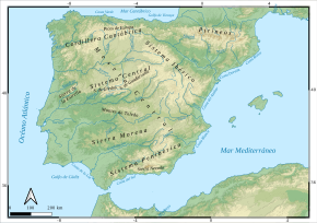
The Iberian Peninsula is the westernmost of the three major southern European peninsulas—the Iberian, Italian, and Balkan.[149] It is bordered on the southeast and east by the Mediterranean Sea, and on the north, west, and southwest by the Atlantic Ocean. The Pyrenees mountains are situated along the northeast edge of the peninsula, where it adjoins the rest of Europe. Its southern tip, located in Tarifa is the southernmost point of the European continent and is very close to the northwest coast of Africa, separated from it by the Strait of Gibraltar and the Mediterranean Sea.
The Iberian Peninsula encompasses 583,254 km2 and has very contrasting and uneven relief.[1] The mountain ranges of the Iberian Peninsula are mainly distributed from west to east, and in some cases reach altitudes of approximately 3000 mamsl, resulting in the region having the second highest mean altitude (637 mamsl) in Western Europe.[1]
The Iberian Peninsula extends from the southernmost extremity at Punta de Tarifa to the northernmost extremity at Punta de Estaca de Bares over a distance between lines of latitude of about 865 km (537 mi) based on a degree length of 111 km (69 mi) per degree, and from the westernmost extremity at Cabo da Roca to the easternmost extremity at Cap de Creus over a distance between lines of longitude at 40° N latitude of about 1,155 km (718 mi) based on an estimated degree length of about 90 km (56 mi) for that latitude. The irregular, roughly octagonal shape of the peninsula contained within this spherical quadrangle was compared to an ox-hide by the geographer Strabo.[150]
| Punta de Estaca de Bares (43°47′38″N 7°41′17″W / 43.79389°N 7.68806°W) |
||
| Cabo da Roca (38°46′51″N 9°29′54″W / 38.78083°N 9.49833°W) |

|
Cap de Creus (42°19′09″N 3°19′19″E / 42.31917°N 3.32194°E) |
| Punta de Tarifa (36°00′15″N 5°36′37″W / 36.00417°N 5.61028°W) |
About three quarters of that rough octagon is the Meseta Central, a vast plateau ranging from 610 to 760 m in altitude.[151] It is located approximately in the centre, staggered slightly to the east and tilted slightly toward the west (the conventional centre of the Iberian Peninsula has long been considered Getafe just south of Madrid). It is ringed by mountains and contains the sources of most of the rivers, which find their way through gaps in the mountain barriers on all sides.
Coastline edit
The coastline of the Iberian Peninsula is 3,313 km (2,059 mi), 1,660 km (1,030 mi) on the Mediterranean side and 1,653 km (1,027 mi) on the Atlantic side.[152] The coast has been inundated over time, with sea levels having risen from a minimum of 115–120 m (377–394 ft) lower than today at the Last Glacial Maximum (LGM) to its current level at 4,000 years BP.[153] The coastal shelf created by sedimentation during that time remains below the surface; however, it was never very extensive on the Atlantic side, as the continental shelf drops rather steeply into the depths. An estimated 700 km (430 mi) length of Atlantic shelf is only 10–65 km (6.2–40.4 mi) wide. At the 500 m (1,600 ft) isobath, on the edge, the shelf drops off to 1,000 m (3,300 ft).[154]
The submarine topography of the coastal waters of the Iberian Peninsula has been studied extensively in the process of drilling for oil. Ultimately, the shelf drops into the Bay of Biscay on the north (an abyss), the Iberian abyssal plain at 4,800 m (15,700 ft) on the west, and Tagus abyssal plain to the south. In the north, between the continental shelf and the abyss, is an extension called the Galicia Bank, a plateau that also contains the Porto, Vigo, and Vasco da Gama seamounts, which form the Galicia interior basin. The southern border of these features is marked by Nazaré Canyon, which splits the continental shelf and leads directly into the abyss.[citation needed]
Rivers edit

The major rivers flow through the wide valleys between the mountain systems. These are the Ebro, Douro, Tagus, Guadiana and Guadalquivir.[155][156] All rivers in the Iberian Peninsula are subject to seasonal variations in flow.
The Tagus is the longest river on the peninsula and, like the Douro, flows westwards with its lower course in Portugal. The Guadiana river bends southwards and forms the border between Spain and Portugal in the last stretch of its course.
Mountains edit
The terrain of the Iberian Peninsula is largely mountainous.[157] The major mountain systems are:
- The Pyrenees and their foothills, the Pre-Pyrenees, crossing the isthmus of the peninsula so completely as to allow no passage except by mountain road, trail, coastal road or tunnel. Aneto in the Maladeta massif, at 3,404 m, is the highest point

- The Cantabrian Mountains along the northern coast with the massive Picos de Europa. Torre de Cerredo, at 2,648 m, is the highest point
- The Galicia/Trás-os-Montes Massif in the Northwest is made up of very old heavily eroded rocks.[158] Pena Trevinca, at 2,127 m, is the highest point
- The Sistema Ibérico, a complex system at the heart of the peninsula, in its central/eastern region. It contains a great number of ranges and divides the watershed of the Tagus, Douro and Ebro rivers. Moncayo, at 2,313 m, is the highest point
- The Sistema Central, dividing the Iberian Plateau into a northern and a southern half and stretching into Portugal (where the highest point of Continental Portugal (1,993 m) is located in the Serra da Estrela). Pico Almanzor in the Sierra de Gredos is the highest point, at 2,592 m
- The Montes de Toledo, which also stretches into Portugal from the La Mancha natural region at the eastern end. Its highest point, at 1,603 m, is La Villuerca in the Sierra de Villuercas, Extremadura
- The Sierra Morena, which divides the watershed of the Guadiana and Guadalquivir rivers. At 1,332 m, Bañuela is the highest point
- The Baetic System, which stretches between Cádiz and Gibraltar and northeast towards Alicante Province. It is divided into three subsystems:
- Prebaetic System, which begins west of the Sierra Sur de Jaén, reaching the Mediterranean Sea shores in Alicante Province. La Sagra is the highest point at 2,382 m.
- Subbaetic System, which is in a central position within the Baetic Systems, stretching from Cape Trafalgar in Cádiz Province across Andalusia to the Region of Murcia.[159] The highest point, at 2,027 m (6,650 ft), is Peña de la Cruz in Sierra Arana.
- Penibaetic System, located in the far southeastern area stretching between Gibraltar across the Mediterranean coastal Andalusian provinces. It includes the highest point in the peninsula, the 3,478 m high Mulhacén in the Sierra Nevada.[160]
Geology edit

The Iberian Peninsula contains rocks of every geological period from the Ediacaran to the Recent, and almost every kind of rock is represented. World-class mineral deposits can also be found there. The core of the Iberian Peninsula consists of a Hercynian cratonic block known as the Iberian Massif. On the northeast, this is bounded by the Pyrenean fold belt, and on the southeast it is bounded by the Baetic System. These twofold chains are part of the Alpine belt. To the west, the peninsula is delimited by the continental boundary formed by the magma-poor opening of the Atlantic Ocean. The Hercynian Foldbelt is mostly buried by Mesozoic and Tertiary cover rocks to the east, but nevertheless outcrops through the Sistema Ibérico and the Catalan Mediterranean System.[citation needed]
The Iberian Peninsula features one of the largest lithium deposits belts in Europe (an otherwise relatively scarce resource in the continent), scattered along the Iberian Massif's Central Iberian Zone and Galicia Tras-Os-Montes Zone.[161] Also in the Iberian Massif, and similarly to other Hercynian blocks in Europe, the peninsula hosts some uranium deposits, largely located in the Central Iberian Zone unit.[162]
The Iberian Pyrite Belt, located in the SW quadrant of the Peninsula, ranks among the most important volcanogenic massive sulphide districts on Earth, and it has been exploited for millennia.[163]
Climate edit
The Iberian Peninsula's location and topography, as well as the effects of large atmospheric circulation patterns induce a NW to SE gradient of yearly precipitation (roughly from 2,000 mm to 300 mm).[164]
The Iberian Peninsula has three dominant climate types. One of these is the oceanic climate seen in the northeast in which precipitation has barely any difference between winter and summer. However, most of Portugal and Spain have a Mediterranean climate; the warm-summer Mediterranean climate and the hot-summer Mediterranean climate, with various differences in precipitation and temperature depending on latitude and position versus the sea, this applies greatly to the Portuguese and Galician Atlantic coasts where, due to upwelling/downwelling phenomena average temperatures in summer can vary through as much as 10 °C (18 °F) in only a few kilometers (e.g. Peniche vs Santarém) There are also more localized steppe climates in central Spain, with temperatures resembling a more continental Mediterranean climate. In other extreme cases highland alpine climates such as in Sierra Nevada and areas with extremely low precipitation and desert climates or semi-desert climates such as the Almería area, Murcia area and southern Alicante area.[165] In the southwestern interior of the Iberian Peninsula the hottest temperatures in Europe are found, with Córdoba averaging around 37 °C (99 °F) in July.[166] The Spanish Mediterranean coast usually averages around 30 °C (86 °F) in summer. In sharp contrast A Coruña at the northern tip of Galicia has a summer daytime high average at just below 23 °C (73 °F).[167] This cool and wet summer climate is replicated throughout most of the northern coastline. Winters in the Peninsula are for the most part, mild, although frosts are common in higher altitude areas of central Spain. The warmest winter nights are usually found in downwelling favourable areas of the west coast, such as on capes. Precipitation varies greatly between regions on the Peninsula, in December for example the northern west coast averages above 200 mm (7.9 in) whereas the southeast can average below 30 mm (1.2 in). Insolation can vary from just 1,600 hours in the Bilbao area, to above 3,000 hours in the Algarve and Gulf of Cádiz.
Political divisions edit

The current political configuration of the Iberian Peninsula comprises the bulk of Portugal and Spain, the whole landlocked microstate of Andorra, a small part of the French department of Pyrénées-Orientales (French Cerdagne), and the British Overseas Territory of Gibraltar.
French Cerdagne is on the south side of the Pyrenees mountain range, which runs along the border between France and Spain.[168][169][170] For example, the Segre river, which runs west and then south to meet the Ebro, has its source on the French side. The Pyrenees range is often considered the northeastern boundary of Iberian Peninsula, although the French coastline curves away from the rest of Europe north of the range, which is the reason why Perpignan, which is also known as the capital of Northern Catalonia, is often considered as the entrance to the Iberian Peninsula.
Regarding Portugal and Spain, this chiefly excludes the Macaronesian archipelagos (the Azores and Madeira of Portugal, and the Canary Islands of Spain), the Balearic Islands (Spain), and the Spanish overseas territories in North Africa (most conspicuously the cities of Ceuta and Melilla, as well as unpopulated islets and rocks).
The countries and territories on the Iberian Peninsula:
| Arms | Flag | Country / Territory | Capital | Area (mainland) |
Population (mainland) |
% of area |
|---|---|---|---|---|---|---|
| Andorra | Andorra la Vella | 468 km2 (181 sq mi) |
84,082 | 0.1 | ||
| French Cerdagne (France) |
Font-Romeu-Odeillo-Via | 539 km2 (208 sq mi) |
12,035 | 0.1 | ||
| Gibraltar (United Kingdom) |
Gibraltar | 7 km2 (2.7 sq mi) |
33,691 | 0.0 | ||
| Portugal (mainland) |
Lisbon | 89,015 km2 (34,369 sq mi) |
9,974,165[171] | 15.3 | ||
| Spain (mainland) |
Madrid | 493,515 km2 (190,547 sq mi) |
ca. 43,731,572[172] | 84.5 | ||
| Total | 583,544 km2 (225,308 sq mi) |
ca. 53,835,545 | 100 | |||
Cities edit


The Iberian city network is dominated by three international metropolises (Barcelona, Lisbon, and Madrid) and four regional metropolises (Bilbao, Porto, Seville, and Valencia).[173] The relatively weak integration of the network favours a competitive approach vis-à-vis the inter-relation between the different centres.[173] Among these metropolises, Madrid stands out within the global urban hierarchy in terms of its status as a major service centre and enjoys the greatest degree of connectivity.[174]
Major metropolitan regions edit
According to Eurostat (2019),[175] the metropolitan regions with a population over one million are listed as follows:
| Metropolitan region | State | Population (2019) |
|---|---|---|
| Madrid | Spain | 6,641,649 |
| Barcelona | Spain | 5,575,204 |
| Lisbon | Portugal | 3,035,332 |
| Valencia | Spain | 2,540,588 |
| Seville | Spain | 1,949,640 |
| Alicante-Elche-Elda | Spain | 1,862,780 |
| Porto | Portugal | 1,722,374 |
| Málaga-Marbella | Spain | 1,660,985 |
| Murcia-Cartagena | Spain | 1,487,663 |
| Cádiz | Spain | 1,249,739 |
| Bilbao | Spain | 1,137,191 |
| Oviedo-Gijón | Spain | 1,022,205 |
Ecology edit
Forests edit

The woodlands of the Iberian Peninsula are distinct ecosystems. Although the various regions are each characterized by distinct vegetation, there are some similarities across the peninsula.
While the borders between these regions are not clearly defined, there is a mutual influence that makes it very hard to establish boundaries and some species find their optimal habitat in the intermediate areas.
The endangered Iberian lynx (Lynx pardinus) is a symbol of the Iberian mediterranean forest and of the fauna of the Iberian Peninsula altogether.[176]
A new Podarcis lizard species, Podarcis virescens, was accepted as a species by the Taxonomic Committee of the Societas Europaea Herpetologica in 2020. This lizard is native to the Iberian Peninsula and found near rivers in the region.
East Atlantic flyway edit
The Iberian Peninsula is an important stopover on the East Atlantic flyway for birds migrating from northern Europe to Africa. For example, curlew sandpipers rest in the region of the Bay of Cádiz.[177]
In addition to the birds migrating through, some seven million wading birds from the north spend the winter in the estuaries and wetlands of the Iberian Peninsula, mainly at locations on the Atlantic coast. In Galicia are Ría de Arousa (a home of grey plover), Ria de Ortigueira, Ria de Corme and Ria de Laxe. In Portugal, the Aveiro Lagoon hosts Recurvirostra avosetta, the common ringed plover, grey plover and little stint. Ribatejo Province on the Tagus supports Recurvirostra arosetta, grey plover, dunlin, bar-tailed godwit and common redshank. In the Sado Estuary are dunlin, Eurasian curlew, grey plover and common redshank. The Algarve hosts red knot, common greenshank and turnstone. The Guadalquivir Marshes region of Andalusia and the Salinas de Cádiz are especially rich in wintering wading birds: Kentish plover, common ringed plover, sanderling, and black-tailed godwit in addition to the others. And finally, the Ebro delta is home to all the species mentioned above.[178]
Languages edit
With the sole exception of Basque, which is of unknown origin,[179] all modern Iberian languages descend from Vulgar Latin and belong to the Western Romance languages.[180] Throughout history (and pre-history), many different languages have been spoken in the Iberian Peninsula, contributing to the formation and differentiation of the contemporaneous languages of Iberia; however, most of them have become extinct or fallen into disuse. Basque is the only non-Indo-European surviving language in Iberia and Western Europe.[181]
In modern times, Spanish (the official language of Spain, spoken by the entire 45 million population in the country, the native language of about 36 million in Europe),[182] Portuguese (the official language of Portugal, with a population over 10 million), Catalan (over 7 million speakers in Europe, 3.4 million with Catalan as first language),[183] Galician (understood by the 93% of the 2.8 million Galician population)[183] and Basque (cf. around 1 million speakers)[184] are the most widely spoken languages in the Iberian Peninsula. Spanish and Portuguese have expanded beyond Iberia to the rest of world, becoming global languages.
Other minority romance languages with some degree of recognition include the several varieties of Astur-leonese, collectively amounting to about 0.6 million speakers,[185] and the Aragonese (barely spoken by the 8% of the 130,000 people inhabiting the Alto Aragón).[186]
English is the official language of Gibraltar. Llanito is a unique language in the territory, an amalgamation of mostly English and Spanish.[187] In Spain, only 54.3% could speak a foreign language, below that of the EU-28 average. Portugal meanwhile achieved 69%, above the EU average, but still below the EU median. Spain ranks 25th out of 33 European countries in the English Proficiency Index.[188]
Transportation edit
Both Spain and Portugal have traditionally used a non-standard rail gauge (the 1,668 mm Iberian gauge) since the construction of the first railroads in the 19th century. Spain has progressively introduced the 1,435 mm standard gauge in its new high-speed rail network (one of the most extensive in the world),[189] inaugurated in 1992 with the Madrid–Seville line, followed to name a few by the Madrid–Barcelona (2008), Madrid–Valencia (2010), an Alicante branch of the latter (2013) and the connection to France of the Barcelona line.[190] Portugal however suspended all the high-speed rail projects in the wake of the 2008 financial crisis, putting an end for the time being to the possibility of a high-speed rail connection between Lisbon, Porto and Madrid.[191]
Handicapped by a mountainous range (the Pyrenees) hindering the connection to the rest of Europe, Spain (and subsidiarily Portugal) only has two meaningful rail connections to France able for freight transport, located at both ends of the mountain range.[192] An international rail line across the Central Pyrenees linking Zaragoza and the French city of Pau through a tunnel existed in the past; however, an accident in the French part destroyed a stretch of the railroad in 1970 and the Canfranc Station has been a cul-de-sac since then.[193]
There are four points connecting the Portuguese and Spanish rail networks: Valença do Minho–Tui, Vilar Formoso–Fuentes de Oñoro, Marvão-Beirã–Valencia de Alcántara and Elvas–Badajoz.[194]
The prospect of the development (as part of a European-wide effort) of the Central, Mediterranean and Atlantic rail corridors is expected to be a way to improve the competitiveness of the ports of Tarragona, Valencia, Sagunto, Bilbao, Santander, Sines and Algeciras vis-à-vis the rest of Europe and the World.[195]
In 1980, Morocco and Spain started a joint study on the feasibility of a fixed link (tunnel or bridge) across the Strait of Gibraltar, possibly through a connection of Punta Paloma with Cape Malabata.[196] Years of studies have, however, made no real progress thus far.[197]
A transit point for many submarine cables, the Fibre-optic Link Around the Globe, Europe India Gateway, and the SEA-ME-WE 3 feature landing stations in the Iberian Peninsula.[198] The West Africa Cable System, Main One, SAT-3/WASC, Africa Coast to Europe also land in Portugal.[198] MAREA, a high capacity communication transatlantic cable, connects the north of the Iberian Peninsula (Bilbao) to North America (Virginia), whereas Grace Hopper is an upcoming cable connecting the Iberian Peninsula (Bilbao) to the UK and the US intended to be operative by 2022[199] and EllaLink is an upcoming high-capacity communication cable expected to connect the Peninsula (Sines) to South America and the mammoth 2Africa project intends to connect the peninsula to the United Kingdom, Europe and Africa (via Portugal and Barcelona) by 2023–24.[200][201]
Two gas pipelines: the Pedro Duran Farell pipeline and (more recently) the Medgaz (from, respectively, Morocco and Algeria) link the Maghreb and the Iberian Peninsula, providing Spain with Algerian natural gas.[202][203] However the contract for the first pipeline expires on 31 October 2021 and—amidst a tense climate of Algerian–Moroccan relations—there are no plans to renew it.[204]
Economy edit
The official currency across Iberia is the Euro, with the exception of Gibraltar, which uses the Gibraltar Pound (at parity with Sterling).[187]
Major industries include mining, tourism, small farms, and fishing. Because the coast is so long, fishing is popular, especially sardines, tuna and anchovies. Most of the mining occurs in the Pyrenees mountains. Commodities mined include: iron, gold, coal, lead, silver, zinc, and salt.
Regarding their role in the global economy, both the microstate of Andorra and the British Overseas Territory of Gibraltar have been described as tax havens.[205]
The Galician region of Spain, in the north-west of the Iberian Peninsula, became one of the biggest entry points of cocaine in Europe, on a par with the Dutch ports.[206] Hashish is smuggled from Morocco via the Strait of Gibraltar.[206]
See also edit
Notes edit
- ^ In the local languages:
- Spanish, Portuguese, Galician, Asturian, and Extremaduran: Península Ibérica (mostly rendered in lowercase in Spanish: península ibérica)
- Spanish: [peˈninsulajˈβeɾika] (the same in Asturian and Extremaduran)
- Portuguese: [pɨˈnĩsulɐ iˈβɛɾikɐ]
- Galician: [peˈninsʊlɐ iˈβɛɾikɐ]
- Catalan: Península Ibèrica
- Catalan pronunciation: [pəˈninsulə iˈβɛɾikə]
- Aragonese and Occitan: Peninsula Iberica
- Aragonese: [peninˈsula iβeˈɾika]
- Occitan: [peninˈsylɔ iβeˈɾikɔ, -beˈʀi-]
- French: Péninsule Ibérique [penɛ̃syl ibeʁik]
- Mirandese: Península Eibérica [pɨˈnĩsulɐ ejˈβɛɾikɐ]
- Basque: Iberiar penintsula [iβeɾiar penints̺ula]
- Spanish, Portuguese, Galician, Asturian, and Extremaduran: Península Ibérica (mostly rendered in lowercase in Spanish: península ibérica)
- ^ In the local languages:
- Spanish, Aragonese, Asturian, Extremaduran and Galician: Iberia
- Spanish: [iˈβeɾja] (the same in Aragonese, Asturian and Extremaduran)
- Galician: [iˈβɛɾjɐ]
- Portuguese and Mirandese: Ibéria
- Portuguese: [iˈβɛɾiɐ]
- Mirandese: [iˈβɛɾiɐ]
- Catalan and Occitan: Ibèria
- Catalan pronunciation: [iˈβɛɾiə]
- Occitan: [iˈβɛɾiɔ, -ˈbɛʀi-]
- French: Ibérie [ibeʁi]
- Basque: Iberia [iβeɾia]
- Spanish, Aragonese, Asturian, Extremaduran and Galician: Iberia
- ^ Christian forces were usually better armoured than their Muslim counterparts, with noble and non-noble milites and cavallers wearing mail hauberks, separate mail coifs and metal helmets, and armed with maces, cavalry axes, sword and lances.[76]
References edit
Citations edit
- ^ a b c Lorenzo-Lacruz et al. 2011, p. 2582.
- ^ Triviño, María; Kujala, Heini; Araújo, Miguel B.; Cabeza, Mar (2018). "Planning for the future: identifying conservation priority areas for Iberian birds under climate change". Landscape Ecology. 33 (4): 659–673. Bibcode:2018LaEco..33..659T. doi:10.1007/s10980-018-0626-z. hdl:10138/309558. ISSN 0921-2973. S2CID 3699212.
- ^ Claire L. Lyons; John K. Papadopoulos (2002). The Archaeology of Colonialism. Getty Publications. pp. 68–69. ISBN 978-0-89236-635-4.
- ^ Strabo. "Book III Chapter 1 Section 6". Geographica.
And also the other Iberians use an alphabet, though not letters of one and the same character, for their speech is not one and the same.
- ^ a b Charles Ebel (1976). Transalpine Gaul: The Emergence of a Roman Province. Brill Archive. pp. 48–49. ISBN 90-04-04384-5.
- ^ Ricardo Padrón (1 February 2004). The Spacious Word: Cartography, Literature, and Empire in Early Modern Spain. University of Chicago Press. p. 252. ISBN 978-0-226-64433-2.
- ^ Carl Waldman; Catherine Mason (2006). Encyclopedia of European Peoples. Infobase Publishing. p. 404. ISBN 978-1-4381-2918-1.
- ^ Strabo (1988). The Geography (in Greek and English). Vol. II. Horace Leonard Jones (trans.). Cambridge: Bill Thayer. p. 118, Note 1 on 3.4.19.
- ^ Herodotus (1827). The nine books of the History of Herodotus, tr. from the text of T. Gaisford, with notes and a summary by P. E. Laurent. p. 75.
- ^ a b Geography III.4.19.
- ^ III.37.
- ^ III.17.
- ^ Félix Gaffiot (1934). Dictionnaire illustré latin-français. Hachette. p. 764.
- ^ Greg Woolf (8 June 2012). Rome: An Empire's Story. Oxford University Press. p. 18. ISBN 978-0-19-997217-3.
- ^ Berkshire Review. Williams College. 1965. p. 7.
- ^ Carlos B. Vega (2 October 2003). Conquistadoras: Mujeres Heroicas de la Conquista de America. McFarland. p. 15. ISBN 978-0-7864-8208-5.
- ^ Virgil (1846). The Eclogues and Georgics of Virgil. Harper & Brothers. p. 377. ISBN 9789644236174.
- ^ Vernet Pons 2014, p. 307.
- ^ Vernet Pons 2014, p. 297.
- ^ "La contribución de Bory de Saint-Vincent (1778–1846) al conocimiento geográfico de la Península Ibérica" (PDF). Archived from the original (PDF) on 25 September 2020. Retrieved 5 April 2020.
- ^ III.3.21.
- ^ White, Horace; Jona Lendering. "Appian's History of Rome: The Spanish Wars (§§6–10)". livius.org. pp. Chapter 7. Archived from the original on 20 December 2008. Retrieved 1 December 2008.
- ^ "Polybius: The Histories: III.6.2". Bill Thayer.
- ^ a b Morris Student Plus, Basque-English dictionary
- ^ a b c d e f g h i j k l m Marcos Saiz (2006), pp. 225–270.
- ^ a b c d e f g Marcos Saiz (2016), pp. 686–696.
- ^ a b c d e Marcos Saiz & Díez (2017), pp. 45–67.
- ^ Adams 2010, p. 208.
- ^ Martí Oliver, Bernat (2012). "Redes y expansión del Neolítico en la Península Ibérica". Rubricatum. Revista del Museu de Gavà (in Spanish) (5). Revistes Catalanes amb Accés Obert: 549–553. ISSN 1135-3791. Retrieved 1 September 2018.
- ^ Olalde, Iñigo; et al. (15 March 2019). "The genomic history of the Iberian Peninsula over the past 8000 years". Science. 363 (6432). American Association for the Advancement of Science: 1230–1234. Bibcode:2019Sci...363.1230O. doi:10.1126/science.aav4040. PMC 6436108. PMID 30872528.
- ^ Case, H (2007). 'Beakers and Beaker Culture' Beyond Stonehenge: Essays on the Bronze Age in honour of Colin Burgess. Oxford: Oxbow. pp. 237–254.
- ^ Ontañón Peredo, Roberto (2003). Caminos hacia la complejidad: el Calcolítico en la región cantábrica. Universidad de Cantabria. p. 72. ISBN 9788481023466.
- ^ García Rivero, Daniel; Escacena Carrasco, José Luis (July–December 2015). "Del Calcolítico al Bronce antiguo en el Guadalquivir inferior. El cerro de San Juan (Coria del Río, Sevilla) y el 'Modelo de Reemplazo'" (PDF). Zephyrus (in Spanish). 76. Universidad de Salamanca: 15–38. doi:10.14201/zephyrus2015761538. ISSN 0514-7336. Retrieved 1 September 2018.
- ^ Vázquez Hoys, Dra. Ana Mª (15 May 2005). Santos, José Luis (ed.). "Los Millares". Revista Terrae Antiqvae (in Spanish). UNED. Archived from the original on 22 May 2022. Retrieved 1 September 2018.
- ^ Lillios, Katina T. (2019). "The Emergence of Ranked Societies. The Late Copper Age To Early Bronze Age (2,500 – 1,500 BCE)". The Archaeology of the Iberian Peninsula. From the Paleolithic to the Bronze Age. Cambridge University Press. p. 227. doi:10.1017/9781316286340.007. S2CID 240899082.
- ^ Legarra Herrero, Borja (2021). "From systems of power to networks of knowledge: the nature of El Argar culture (southeastern Iberia, c. 2200–1500 BC)". In Foxhall, Lin (ed.). Interrogating Networks Investigating networks of knowledge in antiquity. Oxford: Oxbow Books. pp. 47–48. ISBN 978-1-78925-627-7.
- ^ Carrión et al. 2007, p. 1472.
- ^ Chapman, R (2008). "Producing Inequalities: Regional Sequences in Later Prehistoric Southern Spain". Journal of World Prehistory. 21 (3–4): 209–210. doi:10.1007/s10963-008-9014-y. S2CID 162289282.
- ^ Chapman 2008, pp. 208–209.
- ^ Legarra Herrero 2021, p. 52.
- ^ Carrión, J.S.; Fuentes, N.; González-Sampériz, P.; Sánchez-Quirante, L.; Finlayson, J.C.; Fernández, S.; Andrade, A. (2007). "Holocene environmental change in a montane region of southern Europe with a long history of human settlement". Quaternary Science Reviews. 26 (11–12): 1472. Bibcode:2007QSRv...26.1455C. doi:10.1016/j.quascirev.2007.03.013.
- ^ Lugo Enrich, Luis Benítez de; Mejías, Miguel (2017). "The hydrogeological and paleoclimatic factors in the Bronze Age Motillas Culture of La Mancha (Spain): the first hydraulic culture in Europe". Hydrogeology Journal. 25 (7): 1933; 1946. Bibcode:2017HydJ...25.1931B. doi:10.1007/s10040-017-1607-z. hdl:20.500.12468/512. ISSN 1435-0157. S2CID 134088522.
- ^ Valério, Miguel (2008). "Origin and development of the Paleohispanic scripts. the orthography and phonology of the Southwestern alphabet" (PDF). Revista portuguesa de arqueologia. 11 (2): 108–109. ISSN 0874-2782.
- ^ Cunliffe 1995, p. 15.
- ^ Cunliffe 1995, p. 16.
- ^ Ferrer i Jané, Joan (2017). "El origen dual de las escrituras paleohispánicas: un nuevo modelo genealógico" (PDF). Palaeohispanica. 17: 58. ISSN 1578-5386.
- ^ Rodá, Isabel (2013). "Hispania: From the Roman Republic to the Reign of Augustus". In Evans, Jane =DeRose (ed.). A companion to the archaeology of the Roman Republic. John Wiley & Sons, Ltd. p. 526. ISBN 978-1-4051-9966-7.
- ^ Rodá 2013, p. 526.
- ^ Rodá 2013, p. 527.
- ^ Rodá de Llanza, Isabel (2009). "Hispania en las provincias occidentales del imperio durante la república y el alto imperio: una pespectiva arqueológica" (PDF). Institut Català d'Arqueologia Clàssica. p. 197.
- ^ Gosner, L. (2016). "Extraction and empire: multi-scalar approaches to Roman mining communities and industrial landscapes in southwest Iberia". Archaeological Review from Cambridge. 31 (2): 125–126.
- ^ Padilla Peralta, Dan-el (2020). "Epistemicide: the Roman Case". Classica. 33 (2): 161–163. ISSN 2176-6436.
- ^ Curchin, Leonard A. (2014) [1991]. Roman Spain. Conquest and Assimilation. Routledge. pp. 136–153. ISBN 978-0-415-74031-9.
- ^ Rodá 2013, p. 535.
- ^ Rodá 2013, p. 533; 536.
- ^ Zavagno-, Luca (2020). ""No Island is an Island": The Byzantine Mediterranean in The Early Middle Ages (600s-850s)" (PDF). The Legends Avrupa Tarihi Çalışmaları Dergisi. 1 (1): 57–80. doi:10.29228/legends.44375. ISSN 2718-0190. S2CID 226576363.
- ^ Cau Ontiveros, Miguel Ángel; Fantuzzi, Leandro; Tsantini, Evanthia; Mas Florit, Catalina; Chávez-Álvarez, Esther; Gandhi, Ajay (16 December 2020). "Archaeometric characterization of water jars from the Muslim period at the city of Pollentia (Alcúdia, Mallorca, Balearic Islands)". ArcheoSciences. Revue d'archéométrie (44): 7–17. doi:10.4000/archeosciences.7155. ISSN 1960-1360. S2CID 234569616.
- ^ Abraham Ibn Daud's Dorot 'Olam (Generations of the Ages): A Critical Edition and Translation of Zikhron Divrey Romi, Divrey Malkhey Yisra?el, and the Midrash on Zechariah. BRILL. 7 June 2013. p. 57. ISBN 978-90-04-24815-1. Retrieved 10 August 2013.
- ^ Julio Samsó (1998). The Formation of Al-Andalus: History and society. Ashgate. pp. 41–42. ISBN 978-0-86078-708-2. Retrieved 10 August 2013.
- ^ Marín-Guzmán 1991, p. 41–42.
- ^ Marín-Guzmán 1991, p. 43.
- ^ Darío Fernández-Morera (9 February 2016). The Myth of the Andalusian Paradise. Intercollegiate Studies Institute. p. 286. ISBN 978-1-5040-3469-2.
- ^ Marín-Guzmán 1991, p. 47.
- ^ F. E. Peters (11 April 2009). The Monotheists: Jews, Christians, and Muslims in Conflict and Competition, Volume I: The Peoples of God. Princeton University Press. p. 182. ISBN 978-1-4008-2570-7.
- ^ Marín-Guzmán 1991, p. 43–44.
- ^ Marín-Guzmán 1991, p. 45.
- ^ Marín-Guzmán 1991, p. 46.
- ^ Marín-Guzmán 1991, p. 49.
- ^ Marín-Guzmán 1991, p. 48.
- ^ Marín-Guzmán 1991, p. 50.
- ^ Flood 2019, p. 20.
- ^ Constable 1994, p. 3.
- ^ a b Vicens Vives 1970, p. 37.
- ^ Safran 2000, p. 38–42.
- ^ Ladero Quesada 2013, p. 167.
- ^ Warfare in the Medieval World. Pen and Sword. 2006. ISBN 9781848846326.
- ^ Cavanaugh 2016, p. 4.
- ^ Corbera, Laliena; Sénac, Philippe (12 August 2018). "La Reconquista, une entreprise géopolitique complexe". Atlantico.fr.
- ^ García Fitz, Ayala Martínez & Alvira Cabrer 2018, p. 83–84.
- ^ García Fitz, Ayala Martínez & Alvira Cabrer 2018, p. 84.
- ^ Flood 2019, pp. 87–88.
- ^ O'Callaghan 1983, p. 228.
- ^ O'Callaghan 1983, p. 227.
- ^ O'Callaghan 1983, p. 229.
- ^ Buresi 2011, p. 5.
- ^ Buresi 2011, pp. 2–3.
- ^ Constable 1994, p. 2–3.
- ^ a b Rodrigues 2011, p. 7.
- ^ Ruiz 2021, pp. 88, 99.
- ^ a b Wallerstein 2011, p. 49.
- ^ Gillespie 2000, p. 1.
- ^ Wallerstein 2011, p. 49–50.
- ^ Fábregas García 2006, p. 1616.
- ^ Fábregas García 2006, p. 16–17.
- ^ Gillespie 2000, p. 4; Albarrán 2018, p. 37
- ^ Muñoz Bolaños 2012, p. 154.
- ^ a b Ruiz 2017, p. 18.
- ^ Ruiz 2017, p. 19.
- ^ Waugh, W. T. (14 April 2016). A History of Europe: From 1378 to 1494. Routledge. ISBN 9781317217022 – via Google Books.
- ^ a b Phillips 1996, p. 424.
- ^ Berger, Julia Phillips; Gerson, Sue Parker (30 September 2006). Teaching Jewish History. Behrman House, Inc. ISBN 9780867051834 – via Google Books.
- ^ Kantor, Máttis (30 September 2005). Codex Judaica: Chronological Index of Jewish History, Covering 5,764 Years of Biblical, Talmudic & Post-Talmudic History. Zichron Press. ISBN 9780967037837 – via Google Books.
- ^ Aiken, Lisa (1 February 1997). Why Me God: A Jewish Guide for Coping and Suffering. Jason Aronson, Incorporated. ISBN 9781461695479 – via Google Books.
- ^ Ember, Melvin; Ember, Carol R.; Skoggard, Ian (30 November 2004). Encyclopedia of Diasporas: Immigrant and Refugee Cultures Around the World. Volume I: Overviews and Topics; Volume II: Diaspora Communities. Springer Science & Business Media. ISBN 9780306483219 – via Google Books.
- ^ Gilbert 2003, p. 46; Schaff 2013
- ^ Gerber 1994, p. 113.
- ^ Anti-Jewish Riots in the Crown of Aragon and the Royal Response, 1391–1392. Cambridge University Press. 2016. p. 19. ISBN 9781107164512.
- ^ Gloël 2017, p. 55.
- ^ Escribano Páez 2016, pp. 189–191.
- ^ Llorente 1843, p. 19.
- ^ a b González Arévalo 2019, pp. 16–17.
- ^ González Arévalo 2019, p. 16.
- ^ Ladero Quesada 2013, p. 180.
- ^ González Sánchez 2013, p. 350.
- ^ a b González Sánchez 2013, p. 347.
- ^ Religious Refugees in the Early Modern World: An Alternative History of the Reformation. Cambridge University Press. 2015. p. 108. ISBN 9781107024564.
- ^ The Kingfisher History Encyclopedia. Kingfisher. 2004. p. 201. ISBN 9780753457849.
- ^ Beck, Bernard (30 September 2012). True Jew: Challenging the Stereotype. Algora Publishing. ISBN 9780875869032 – via Google Books.
- ^ Strom, Yale (30 September 1992). The Expulsion of the Jews: Five Hundred Years of Exodus. SP Books. p. 9. ISBN 9781561710812 – via Archive.org.
- ^ NELSON, CARY R. (11 July 2016). Dreams Deferred: A Concise Guide to the Israeli-Palestinian Conflict and the Movement to Boycott Israel. Indiana University Press. ISBN 9780253025180 – via Google Books.
- ^ "Islamic Encounters". www.brown.edu. Brown University. Retrieved 25 May 2023.
Between 1492 and 1610, some 3,000,000 Muslims voluntarily left or were expelled from Spain, resettling in North Africa.
- ^ Gitlitz, David Martin (30 September 2002). Secrecy and Deceit: The Religion of the Crypto-Jews. UNM Press. ISBN 9780826328137 – via Google Books.
- ^ The Jewish Time Line Encyclopedia: A Year-by-Year History From Creation to the Present. Jason Aronson, Incorporated. December 1993. p. 178. ISBN 9781461631491.
- ^ Latin America in Colonial Times. Cambridge University Press. 2018. p. 27. ISBN 9781108416405.
- ^ Pavlac, Brian A. (19 February 2015). A Concise Survey of Western Civilization: Supremacies and Diversities throughout History. Rowman & Littlefield. ISBN 9781442237681 – via Google Books.
- ^ Jaleel, Talib (11 July 2015). "Notes on Entering Deen Completely: Islam as its followers know it". EDC Foundation – via Google Books.
- ^ Majid, Anouar (30 September 2009). We are All Moors: Ending Centuries of Crusades Against Muslims and Other Minorities. U of Minnesota Press. ISBN 9780816660797 – via Google Books.
- ^ "Special Initiative: Thucydides Trap". Belfer Center for Science and International Affairs. 3 September 1939. Retrieved 12 January 2024.
- ^ el-Ojeili 2015, p. 4.
- ^ Wallerstein 2011, p. 169–170.
- ^ O'Brien & Prados de la Escosura 1998, p. 37–38.
- ^ Wallerstein 2011, p. 116–117.
- ^ Wallerstein 2011, p. 117.
- ^ Liang et al. 2013, p. 23.
- ^ Halikowski Smith, Stefan (2018). "Lisbon in the sixteenth century: decoding the Chafariz d'el Rei". Race & Class. 60 (2): 1–19. doi:10.1177/0306396818794355. S2CID 220080922.
- ^ Barrios 2015, p. 52.
- ^ Nemser 2018, p. 117.
- ^ Gelabert 1994, p. 183.
- ^ a b Gelabert 1994, p. 183–184.
- ^ Miranda 2017, p. 75–76.
- ^ Miranda 2017, p. 76.
- ^ O'Flanagan 2008, p. 18.
- ^ a b Yun Casalilla 2019, p. 418.
- ^ Yun Casalilla 2019, pp. 421, 423.
- ^ Yun Casalilla 2019, p. 424.
- ^ Yun Casalilla 2019, p. 425—426.
- ^ Yun Casalilla 2019, p. 428—429.
- ^ Silveira et al. 2013, p. 172.
- ^ Sánchez Blanco 1988, pp. 21–32.
- ^ III.1.3.
- ^ Fischer, T (1920). "The Iberian Peninsula: Spain". In Mill, Hugh Robert (ed.). The International Geography. New York and London: D. Appleton and Company. pp. 368–377.
- ^ These figures sum the figures given in the Wikipedia articles on the geography of Spain and Portugal. Most figures from Internet sources on Spain and Portugal include the coastlines of the islands owned by each country and thus are not a reliable guide to the coastline of the peninsula. Moreover, the length of a coastline may vary significantly depending on where and how it is measured.
- ^ Edmunds, WM; K Hinsby; C Marlin; MT Condesso de Melo; M Manyano; R Vaikmae; Y Travi (2001). "Evolution of groundwater systems at the European coastline". In Edmunds, W. M.; Milne, C. J. (eds.). Palaeowaters in Coastal Europe: Evolution of Groundwater Since the Late Pleistocene. London: Geological Society. p. 305. ISBN 1-86239-086-X.
- ^ "Iberian Peninsula – Atlantic Coast". An Atlas of Oceanic Internal Solitary Waves (PDF). Global Ocean Associates. February 2004. Retrieved 9 December 2008.
- ^ "Los 10 ríos mas largos de España". 20 Minutos (in Spanish). 30 May 2013. Retrieved 1 September 2018.
- ^ "2. El territorio y la hidrografía española: ríos, cuencas y vertientes". Junta de Andalucía. Archived from the original on 9 April 2022. Retrieved 1 September 2018.
- ^ Manzano Cara, José Antonio. "Tema 8.- El Relieve de España" (PDF) (in Spanish). Junta de Andalucía. Retrieved 1 September 2018.
- ^ Piçarra, José Manuel; Gutiérrez-Marco, J. C.; Sá, Artur A.; Meireles, Carlos; González-Clavijo, E. (1 June 2006). "Silurian graptolite biostratigraphy of the Galicia – Tras-os-Montes Zone (Spain and Portugal)". GFF. 128 (2): 185. Bibcode:2006GFF...128..185P. doi:10.1080/11035890601282185. hdl:10261/30737. ISSN 1103-5897. S2CID 140712259.
- ^ Edited by W Gibbons & T Moreno, Geology of Spain, 2002, ISBN 978-1-86239-110-9
- ^ Jones, Peter. "Introduction to the Birds of Spain". Spanishnature.com. Archived from the original on 8 August 2020. Retrieved 11 April 2013.
- ^ Rodrigues, Pedro M. S. M.; Antão, Ana Maria M. C.; Rodrigues, Ricardo (2019). "Evaluation of the impact of lithium exploitation at the C57 mine (Gonçalo, Portugal) on water, soil and air quality". Environmental Earth Sciences (78): 1. doi:10.1007/s12665-019-8541-4.
- ^ Dahlkamp 1991, pp. 232–233.
- ^ Tornos, F.; López Pamo, E.; Sánchez España, F.J. (2008). "The Iberian Pyrite Belt" (PDF). Contextos geológicos españoles: una aproximación al patrimonio geológico de relevancia internacional. Instituto Geológico y Minero de España. p. 57.
- ^ Lorenzo-Lacruz et al. 2011, pp. 2582–2583.
- ^ "IBERIAN CLIMATE ATLAS" (PDF). Aemet.es. Retrieved 22 March 2024.
- ^ "Standard climate values for Córdoba". Aemet.es. Retrieved 7 March 2015.
- ^ "Standard climate values for A Coruña". Aemet.es. Retrieved 7 March 2015.
- ^ Sahlins 1989, p. 49.
- ^ Paul Wilstach (1931). Along the Pyrenees. Robert M. McBride Company. p. 102.
- ^ James Erskine Murray (1837). A Summer in the Pyrenees. J. Macrone. p. 92.
- ^ População residente (Série longa, início 1991 - N.º) por Local de residência (NUTS - 2013), Sexo e Idade; Anual 2022, "INE 2022"
- ^ Census data, "Official Spanish census"
- ^ a b Sánchez Moral 2011, p. 312.
- ^ Sánchez Moral 2011, p. 313.
- ^ "Population on 1 January by broad age group, sex and metropolitan regions". Eurostat.
- ^ Conservación Ex situ del Lince Ibérico: Un Enfoque Multidisciplinar (PDF). Fundación Biodiversidad. 2009. pp. XI & 527.
- ^ Hortas, Francisco; Jordi Figuerols (2006). "Migration pattern of Curlew Sandpipers Calidris ferruginea on the south-western coastline of the Iberian Peninsula" (PDF). International Wader Studies. 19: 144–147. Archived from the original (PDF) on 17 December 2008. Retrieved 7 December 2008.
- ^ Dominguez, Jesus (1990). "Distribution of estuarine waders wintering in the Iberian Peninsula in 1978–1982" (PDF). Wader Study Group Bulletin. 59: 25–28.
- ^ "El misterioso origen del euskera, el idioma más antiguo de Europa". Semana (in Spanish). 18 September 2017. Retrieved 1 September 2018.
- ^ Fernández Jaén, Jorge. "El latín en Hispania: la romanización de la Península Ibérica. El latín vulgar. Particularidades del latín hispánico". Biblioteca Virtual Miguel de Cervantes (in Spanish). Retrieved 1 September 2018.
- ^ Echenique Elizondo, M.ª Teresa (March 2016). "Lengua española y lengua vasca: Una trayectoria histórica sin fronteras" (PDF). Revista de Filología (in Spanish) (34). Instituto Cervantes: 235–252. ISSN 0212-4130. Retrieved 1 September 2018.
- ^ Andreose & Renzi 2013, pp. 289–290.
- ^ a b Andreose & Renzi 2013, p. 293.
- ^ "El Gobierno Vasco ha presentado los resultados más destacados de la V. Encuesta Sociolingüística de la CAV, Navarra e Iparralde". Eusko Jaurlaritza (in Basque). 18 July 2012. Retrieved 1 September 2018.
- ^ Andreose & Renzi 2013, pp. 290–291.
- ^ Andreose & Renzi 2013, p. 291.
- ^ a b "Gibraltar Fact Sheets". Government of Gibraltar. Retrieved 4 November 2022.
- ^ Zafra, Ignacio (11 November 2019). "Spain continues to have one of the worst levels of English in Europe". El País. Retrieved 4 November 2022.
- ^ Zembri & Libourel 2017, p. 368.
- ^ Zembri & Libourel 2017, p. 371.
- ^ Zembri & Libourel 2017, p. 382.
- ^ Fernández de Alarcón 2015, p. 45.
- ^ Barrenechea, Eduardo (10 January 1983). "El Canfranc: un ferrocarril en vía muerta". El País.
- ^ Palmeiro Piñeiro & Pazos Otón 2008, p. 227.
- ^ Fernández de Alarcón 2015, p. 50.
- ^ García Álvarez 1996, p. 7; 11.
- ^ Leadbeater, Chris (31 May 2018), "Will a Tunnel from Spain to Africa Ever Be Built—And Who Would Use It?", The Telegraph, archived from the original on 19 December 2000.
- ^ a b "Madrid΄s Position in the Global Telecommunications Landscape" (PDF). DE-CIX. p. 2. Archived from the original (PDF) on 16 June 2020. Retrieved 16 June 2020.
- ^ "Grace Hopper: el gran cable submarino de Google llega a España". Expansión. 9 September 2021.
- ^ Castillo, Carlos del (19 December 2019). ""El callejón del silicio": el plan para que 'la nube' del sur de Europa se instale en España". Eldiario.es.
- ^ López, José María (13 June 2020). "Los cables submarinos que conectan España con el mundo a través de internet". Hipertextual.
- ^ Ghilès 2008, pp. 96–97.
- ^ Montaño, Baltasar (30 May 2014). "Saltan las alarmas: la dependencia energética con Argelia roza el 60% en pleno conflicto en Ucrania". Voz Pópuli.
- ^ Juliana, Enric (29 September 2021). "Fatídico triángulo: Argelia, Marruecos, España". La Vanguardia.
- ^ Cooley 2005, p. 167.
- ^ a b Labrousse, Alain; Laniel, Laurent, eds. (2001). "Europe". The World Geopolitics of Drugs, 1998/1999. pp. 117, 123. doi:10.1007/978-94-017-3505-6. ISBN 978-94-017-3505-6.
Bibliography edit
- Adams, Jonathan (26 February 2010). Species Richness: Patterns in the Diversity of Life. Springer. p. 208. ISBN 978-3-540-74278-4.
- Andreose, Alvise; Renzi, Lorenzo (2013). "Geography and distribution of the Romance languages in Europe". In Maiden, Martin; Smith, John Charles; Ledgeway, Adam (eds.). The Cambridge History of the Romance Languages. Vol. II. Cambridge University Press. p. 283. ISBN 978-0-521-80073-0.
- Albarrán, Javier (2018). "Granada". War in the Iberian Peninsula, 700-1600. Routledge. pp. 36–53. ISBN 978-1-138-70745-0.
- Barrios, Feliciano (2015). La gobernación de la Monarquía de España. Consejos, Juntas y Secretarios de la Administración de Corte (1556-1700). Madrid: Centro de Estudios Políticos y Constitucionales, Agencia Estatal Boletín Oficial del Estado; Fundación Rafael del Pino. ISBN 978-84-340-2266-9.
- Buresi, Pascal (2011). "The Appearance of the Frontier Concept in the Iberian Peninsula: at the Crossroads of Local, National and Pontifical Strategies (11 th −13 th Centuries)". Quaestiones Medii Aevi Novae (16). Warsaw: Instytut historyczny: 81–99.
- Cavanaugh, Stephanie Maria (2016). The Morisco problem and the politics of belonging in sixteenth-century Valladolid (PDF). University of Toronto.
- Constable, Olivia Remie (1994). Trade and Traders in Muslim Spain: The Commercial Realignment of the Iberian Peninsula, 900–1500. Cambridge University Press. ISBN 978-0-521-56503-5.
- Cooley, Alexander (2005). Logics of Hierarchy: The Organization of Empires, States, and Military Occupation. Ithaca & London: Cornell University Press. ISBN 978-0-8014-6249-8.
- Cunliffe, Barry (1995). "Diversity in the Landscape: The Geographical Background to Urbanism in Iberia" (PDF). In Cunliffe, Barry; Keay, Simon (eds.). Social Complexity and the Development of Towns in Iberia, From the Copper Age to the Second Century AD. pp. 5–28. S2CID 54654511. Archived (PDF) from the original on 9 February 2020. Retrieved 30 April 2021.
- Dahlkamp, Franz J. (1991). Uranium Ore Deposits. doi:10.1007/978-3-662-02892-6. ISBN 978-3-662-02892-6.
- el-Ojeili, Chamsy (2015). "Reflections on Wallerstein: The Modern World-System, Four Decades on". Critical Sociology. 41 (4–5): 679–700. doi:10.1177/0896920513497377. ISSN 0896-9205. S2CID 13860079.
- Escribano Páez, José Miguel (2016). "Negotiating with the "Infidel": Imperial Expansion and Cross-Confessional Diplomacy in the Early Modern Maghreb (1492–1516)". Itinerario. 40 (2): 189–214. doi:10.1017/s0165115316000310. S2CID 232251871.
- Fábregas García, Adela (2006). "La integración del reino nazarí de Granada en el espacio comercial europeo (siglos XIII–XV)". Investigaciones de Historia Económica (in Spanish). 2 (6): 11–39. doi:10.1016/S1698-6989(06)70266-1.
- Fernández de Alarcón, Rafael (2015). "Decisiones fundamentales para el transporte de mercancías en España y con Europa" (PDF). Revista de Obras Públicas (3563): 43–50. ISSN 0034-8619. Archived from the original (PDF) on 26 February 2021. Retrieved 12 February 2020.
- Flood, Timothy M. (2019). Rulers and Realms in Medieval Iberia, 711–1492. Jefferson: McFarland & Company. ISBN 978-1-4766-7471-1.
- García Álvarez, Vicente (1996). "El proyecto de enlace fijo a través del estrecho de Gibraltar. Situación actual de los estudios" (PDF). Revista de Obras Públicas (3360). ISSN 0034-8619. Archived from the original (PDF) on 11 April 2021. Retrieved 12 February 2020.
- García Fitz, Francisco; Ayala Martínez, Carlos de; Alvira Cabrer, Martín (2018). "Castile-Leon. I. Early and High Middle Ages (8th to 13th centuries)". War in the Iberian Peninsula, 700–1600. Routledge. pp. 54–93. ISBN 978-1-138-70745-0.
- Gelabert, Juan E. (1994). "Urbanisation and deurbanisation in Castile, 1500–1800". In Thompson, I. A. A.; Yun Casalilla, Bartolomé (eds.). The Castilian Crisis of the Seventeenth Century: New Perspectives on the Economic and Social History of Seventeenth-Century Spain. Cambridge University Press. pp. 182–205. ISBN 978-0-521-41624-5.
- Gerber, Jane S. (1994). Jews of Spain: A History of the Sephardic Experience. Simon and Schuster. ISBN 9780029115749.
- Ghilès, Francis (2008). "A Unified North Africa on the World State: Overview of Maghreb Sector Studies". In Hufbauer, Gary Clyde; Brunel, Claire (eds.). Maghreb Regional and Global Integration: A Dream to be Fulfilled (PDF). Washington, DC: Peterson Institute for International Economics. pp. 93–100.
- Gilbert, Martin (2003) [1969]. The Routledge Atlas of Jewish History. Routledge. ISBN 9780415281508.
- Gillespie, Richard (2000). "Spain's Illusive Mediterranean Empire". Spain and the Mediterranean: Developing a European Policy towards the South. London: Palgrave Macmillan. pp. 1–21. doi:10.1057/9780230595675_1. ISBN 978-1-349-40575-6.
- Gloël, Matthias (2017). "Los cambios dinásticos en Portugal de 1383/85 y 1580: una reflexión comparativa". Revista Chilena de Estudios Medievales (11): 44–67. ISSN 0719-689X. Archived from the original on 26 November 2021. Retrieved 9 February 2020.
- González Arévalo (2019). "La esclavitud en la España Medieval. (siglos XIV-XV). Generalidades y rasgos diferenciales". Millars: Espai i Història (47). Castellón de la Plana: Universitat Jaime I: 11–37. doi:10.6035/Millars.2019.47.2. hdl:10234/187209. ISSN 1132-9823.
- González Sánchez, Santiago (2013). Las relaciones exteriores de Castilla a comienzos del siglo XV: la minoría de Juan II (1407–1420). Comité Español de Ciencias Históricas. ISBN 978-84-15069-56-0.
- Ladero Quesada, Miguel Ángel (2013). "Población de las ciudades en la Baja Edad Media (Castilla, Aragón, Navarra)" (PDF). I Congresso Histórico Internacional. As cidades na história: População. Câmara Municipal de Guimarães. pp. 167–201. ISBN 978-989-8474-11-7.
- Liang, Yuen-Gen; Balbale, Abigail Krasner; Devereux, Andrew; Gómez-Rivas, Camillo (2013). "Unity and Disunity across the Strait of Gibraltar". In Liang, Yuen-Gen; Balbale, Abigail Krasner; Devereux, Andrew; Gómez-Rivas, Camillo (eds.). Spanning the Strait: Studies in Unity in the Western Mediterranean. Leiden & Boston: BRILL. pp. 1–40. ISBN 978-90-04-25663-7.
- Llorente, Juan Antonio (1843). The History of the Inquisition of Spain: From the Time of Its Establishment to the Reign of Ferdinand VII., Composed from the Original Documents of the Archives of the Supreme Council and from Those of Subordinate Tribunals of the Holy Office. James M. Campbell & Company.
- Lorenzo-Lacruz, J.; Vicente-Serrano, S. M.; López-Moreno, J.I.; González-Hidalgo, J.C.; Morán-Tejeda, E. (2011). "The response of Iberian rivers to the North Atlantic Oscillation" (PDF). Hydrology and Earth System Sciences. 15 (8): 2581–2597. Bibcode:2011HESS...15.2581L. doi:10.5194/hess-15-2581-2011.
- Marcos Saiz, F. Javier (2006). La Sierra de Atapuerca y el Valle del Arlanzón. Patrones de asentamiento prehistóricos. Editorial Dossoles. Burgos, Spain. ISBN 9788496606289.
- Marcos Saiz, F. Javier (2016). La Prehistoria Reciente del entorno de la Sierra de Atapuerca (Burgos, España). British Archaeological Reports (Oxford, U.K.), BAR International Series 2798. ISBN 9781407315195.
- Marcos Saiz, F.J.; Díez, J.C. (2017). "The Holocene archaeological research around Sierra de Atapuerca (Burgos, Spain) and its projection in a GIS geospatial database". Quaternary International. 433 (A): 45–67. Bibcode:2017QuInt.433...45M. doi:10.1016/j.quaint.2015.10.002.
- Marín-Guzmán, Roberto (1991). "Ethnic groups and social classes in Muslim Spain". Islamic Studies. 30 (1/2): 37–66. ISSN 0578-8072. JSTOR 20840024.
- Miranda, Susana Münch (2017). "Coping with Europe and the Empire, 1500–1620". In Freire, Dulce; Lains, Pedro (eds.). An Agrarian History of Portugal, 1000-2000: Economic Development on the European Frontier. Leiden & Boston: Brill. ISBN 978-90-04-31152-7.
- Muñoz Bolaños, Roberto (2012). "El Salado. El fin del problema del estrecho". Revista Universitaria de Historia Militar. 1 (2): 153–184. ISSN 2254-6111.
- Nemser, Daniel (2018). "The Iberian Slave Trade and the Racialization of Freedom". History of the Present. 8 (2): 117–139. doi:10.5406/historypresent.8.2.0117. ISSN 2159-9785. JSTOR 10.5406/historypresent.8.2.0117.
- O'Brien, Patrick Karl; Prados de la Escosura, Leandro (1998). "The Costs and Benefits for Europeans from their Empires Overseas". Revista de Historia Economica. 16: 29–89. doi:10.1017/S0212610900007059. S2CID 154976233.
- O'Callaghan, Joseph F. (1983) [1975]. A History of Medieval Spain. Ithaca & London: Cornell University Press. ISBN 978-0-8014-9264-8.
- O'Flanagan, Patrick (2008). Port Cities of Atlantic Iberia, c. 1500–1900. Ashgate. ISBN 978-0-7546-6109-2.
- Palmeiro Piñeiro, José Luis; Pazos Otón, Miguel (2008). "La Eurorregión Galicia-norte de Portugal: una aproximación a la movilidad en el contexto ibérico". Estudios Geográficos (in Spanish). 69 (264). Madrid: Consejo Superior de Investigaciones Científicas: 215–245. doi:10.3989/egeogr.2008.i264.86. ISSN 1988-8546.
- Phillips, William D. (1996). "The Spanish Kingdoms and the Wider World in the Later Middle Ages". In Chevedden, P.E. Jr.; Kagay, D.J.; Padilla, P.G. (eds.). Iberia and the Mediterranean World of the Middle Ages. Vol. II. Brill. pp. 407–430. ISBN 90-04-10573-5.
- Rodrigues, José Damião (2011). "The Flight of the Eagle: an Island Tribute to the Universal Iberian Monarchy at the End of the Sixteenth Century" (PDF). e-Journal of Portuguese History. 9 (2): 1–34. ISSN 1645-6432.
- Ruiz, Teofilo F. (2017). Spanish Society, 1348–1700. Routledge. ISBN 978-1-351-72091-5.
- Ruiz, Teófilo F. (2021). "Power and Politics in Iberian Societies c. 1035–1516". In Gerli, E. Michael; Giles, Ryan (eds.). The Routledge Hispanic Studies Companion to Medieval Iberia. Unity in Diversity. Routledge. ISBN 978-1-138-62932-5.
- Safran, Janina M. (2000). The Second Umayyad Caliphate: The Articulation of Caliphal Legitimacy in Al-Andalus. Harvard University Press. ISBN 0-932885-24-1.
- Sahlins, Peter (1989). Boundaries: The Making of France and Spain in the Pyrenees. University of California Press. ISBN 978-0-520-91121-5.
- Sánchez Blanco, Víctor (1988). "Las redes de Transporte entre la Península Ibérica y el resto de Europa". Cuadernos de Estrategia (in Spanish) (7): 21–32. ISSN 1697-6924 – via Dialnet.
- Sánchez Moral, Simón (2011). "Iberian Cities". In Taylor, Peter J.; Ni, Pengfei; Derudder, Ben; Hoyer, Michael; Huang, Jing; Witlox, Frank (eds.). Global Urban Analysis: A Survey of Cities in Globalization. London & Washington, DC: Earthscan. pp. 312–317. ISBN 978-1-84971-213-2.
- Schaff, Philip (2013). The Christian Church from the 1st to the 20th Century. Delmarva Publications.
- Silveira, Luís Espinha da; Alves, Daniel; Painho, Marco; Costa, Ana Cristina; Alcântara, Ana (2013). "The Evolution of Population Distribution on the Iberian Peninsula: A Transnational Approach (1877–2001)". Historical Methods: A Journal of Quantitative and Interdisciplinary History. 46 (3): 157–174. doi:10.1080/01615440.2013.804787. hdl:10362/11027. S2CID 53334755.
- Vernet Pons, Mariona (2014). "The Origin of the Name Sepharad: A New Interpretation". Journal of Semitic Studies. 59 (2): 297–313. doi:10.1093/jss/fgu002. hdl:2445/164860.
- Vicens Vives, Jaime (1970) [1967]. Approaches to the History of Spain. University of California Press. p. 37. ISBN 978-0-520-01422-0.
- Wallerstein, Immanuel (2011) [1974]. The Modern World-System I: Capitalist Agriculture and the Origins of the European World-Economy in the Sixteenth Century. University of California Press.
- Yun Casalilla, Bartolomé (2019). Iberian World Empires and the Globalization of Europe 1415–1668. Palgrave Macmillan. ISBN 978-9811308338.
- Zembri, Pierre; Libourel, Eloïse (2017). "Towards oversized high-speed rail systems? Some lessons from France and Spain". Transportation Research Procedia. 25 (25): 368–385. doi:10.1016/j.trpro.2017.05.414. ISSN 2352-1465.
External links edit
- Arioso, Pāolā; Diego Meozzi. "Iberian Peninsula•Links". Stone Pages. Retrieved 5 December 2008.
- Flores, Carlos; Maca-Meyer, Nicole; González, Ana M.; Oefner, Peter J.; Shen, Peidong; Pérez, Jose A.; Rojas, Antonio; Larruga, Jose M.; Underhill, Peter A. (2004). "Reduced genetic structure of the Iberian Peninsula revealed by Y-chromosome analysis: implications for population demography". European Journal of Human Genetics. 12 (10): 855–863. doi:10.1038/sj.ejhg.5201225. PMID 15280900. S2CID 16765118.
- Loyd, Nick (2007). "IberiaNature: A guide to the environment, climate, wildlife, geography and nature of Spain". Retrieved 4 December 2008.
- de Silva, Luís Fraga. "Ethnologic Map of Pre-Roman Iberia (circa 200 B.C.). NEW VERSION #10" (in English, Portuguese, and Latin). Associação Campo Arqueológico de Tavira, Tavira, Portugal. Archived from the original on 6 October 2008. Retrieved 4 December 2008.