
KNOWPIA
WELCOME TO KNOWPIA

National Register of Historic Places listings in Beaver County, Oklahoma 
Summary
This is a list of the National Register of Historic Places listings in Beaver County, Oklahoma.

This is intended to be a complete list of the properties on the National Register of Historic Places in Beaver County, Oklahoma, United States. The locations of National Register properties for which the latitude and longitude coordinates are included below, may be seen in a map.[1]
There are 11 properties listed on the National Register in the county.
This National Park Service list is complete through NPS recent listings posted April 12, 2024.[2]
Current listings edit
| [3] | Name on the Register[4] | Image | Date listed[5] | Location | City or town | Description |
|---|---|---|---|---|---|---|
| 1 | Beaver County Courthouse | 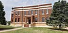 |
August 23, 1984 (#84002964) |
Off U.S. Route 270 36°48′57″N 100°31′16″W / 36.815833°N 100.521111°W | Beaver | Red brick 75 by 75 feet (23 m × 23 m) two-story courthouse built in 1926 around old 1907 courthouse |
| 2 | Floris Grain Elevator | October 7, 1983 (#83004159) |
Off U.S. Route 64 36°52′13″N 100°42′28″W / 36.870278°N 100.707778°W | Floris | ||
| 3 | Gate School |  |
September 10, 1999 (#99001087) |
Junction of 4th and Texas 36°51′18″N 100°03′23″W / 36.855°N 100.056389°W | Gate | |
| 4 | Knowles Grain Elevator | 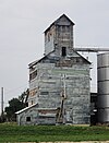 |
May 13, 1983 (#83002069) |
U.S. Route 64 36°52′28″N 100°11′30″W / 36.874444°N 100.191667°W | Knowles | |
| 5 | Lane Cabin |  |
June 5, 1974 (#74001654) |
Main St. and Ave. C 36°49′05″N 100°31′08″W / 36.818023°N 100.518835°W | Beaver | |
| 6 | Lonker Archeological Site | November 27, 1978 (#78002218) |
Address Restricted | Gate | ||
| 7 | Old Settler's Irrigation Ditch | July 27, 1983 (#83002070) |
Intersects U.S. Route 283 north of Rosston 36°56′55″N 99°57′47″W / 36.948611°N 99.963056°W | Rosston | ||
| 8 | Presbyterian Church | 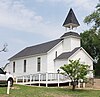 |
May 16, 1974 (#74001655) |
3rd St. and Ave. E 36°48′53″N 100°31′16″W / 36.814776°N 100.52122°W | Beaver | |
| 9 | Billy Rose Archeological Site | September 1, 1978 (#78002219) |
Address Restricted | Mocane | ||
| 10 | Sharps Creek Crossing Site | April 4, 1975 (#75001559) |
Address Restricted | Turpin | ||
| 11 | Turpin Grain Elevator | May 13, 1983 (#83002071) |
Off U.S. Route 64 36°52′45″N 100°52′35″W / 36.879167°N 100.876389°W | Turpin |
See also edit
References edit
- ^ The latitude and longitude information provided in this table was derived originally from the National Register Information System, which has been found to be fairly accurate for about 99% of listings. Some locations in this table may have been corrected to current GPS standards.
- ^ National Park Service, United States Department of the Interior, "National Register of Historic Places: Weekly List Actions", retrieved April 12, 2024.
- ^ Numbers represent an alphabetical ordering by significant words. Various colorings, defined here, differentiate National Historic Landmarks and historic districts from other NRHP buildings, structures, sites or objects.
- ^ "National Register Information System". National Register of Historic Places. National Park Service. March 13, 2009.
- ^ The eight-digit number below each date is the number assigned to each location in the National Register Information System database, which can be viewed by clicking the number.