
KNOWPIA
WELCOME TO KNOWPIA

National Register of Historic Places listings in Lewis County, Washington 
Summary
This is a list of the National Register of Historic Places listings in Lewis County, Washington.

This is intended to be a complete list of the properties and districts on the National Register of Historic Places in Lewis County, Washington, United States. Latitude and longitude coordinates are provided for many National Register properties and districts; these locations may be seen together in a map.[1]
There are 41 properties and districts listed on the National Register in the county. Another 2 properties were once listed but have been removed.
This National Park Service list is complete through NPS recent listings posted April 12, 2024.[2]
Current listings edit
| [3] | Name on the Register[4] | Image | Date listed[5] | Location | City or town | Description |
|---|---|---|---|---|---|---|
| 1 | George E. Birge House |  |
December 1, 1986 (#86003375) |
715 E St. 46°43′26″N 122°57′20″W / 46.723889°N 122.955556°W | Centralia | |
| 2 | Boistfort High School |  |
August 6, 1987 (#87001335) |
983 Boistfort Rd. 46°32′59″N 123°07′55″W / 46.549722°N 123.131944°W | Curtis | Rural Public Schools of Washington State MPS |
| 3 | Joseph Borst House |  |
December 27, 1977 (#77001345) |
302 Bryden Ave. 46°43′13″N 122°58′55″W / 46.720278°N 122.981944°W | Centralia | Architect: Jacob Ort |
| 4 | Burlington Northern Depot | 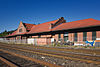 |
November 6, 1974 (#74001967) |
Off U.S. 99 46°40′18″N 122°58′16″W / 46.671667°N 122.971111°W | Chehalis | Also known as Chehalis Passenger Station. Now it is the Lewis County Historical Museum. |
| 5 | Centralia Downtown Historic District | 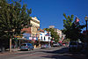 |
August 18, 2003 (#03000164) |
Roughly bounded by Center St., Burlington Northern right-of-way, Walnut st., and Pearl St. 46°43′02″N 122°57′13″W / 46.717222°N 122.953611°W | Centralia | |
| 6 | Centralia Union Depot | 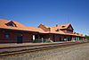 |
May 19, 1988 (#88000608) |
210 Railroad St. 46°43′04″N 122°57′08″W / 46.717778°N 122.952222°W | Centralia | |
| 7 | Chehalis Downtown Historic District |  |
November 21, 1997 (#97001407) |
Roughly bounded by Park, and Front Sts., Washington and Cascade Aves. 46°39′56″N 122°58′08″W / 46.665556°N 122.968889°W | Chehalis | |
| 8 | Claquato Church |  |
April 24, 1973 (#73001882) |
Off WA 6 46°38′35″N 123°01′13″W / 46.643056°N 123.020278°W | Claquato | |
| 9 | Wesley Everest Gravesite |  |
December 17, 1991 (#91001781) |
Sticklin-Greenwood Memorial Park, 1905 Johnson Rd. 46°44′11″N 122°58′51″W / 46.736389°N 122.980833°W | Centralia | |
| 10 | Grace Evangelical Church of Vader |  |
March 28, 2003 (#03000162) |
618 D St. 46°24′08″N 122°57′16″W / 46.402222°N 122.954444°W | Vader | |
| 11 | Hillside Historic District |  |
August 1, 1996 (#96000841) |
Roughly bounded by Jefferson Ave., Hill St., Washington Ave., and 9th St. 46°39′42″N 122°57′39″W / 46.661667°N 122.960833°W | Chehalis | |
| 12 | Holy Cross Polish National Catholic Church |  |
September 2, 1987 (#87001456) |
Third and Queen 46°34′04″N 123°17′57″W / 46.567778°N 123.299167°W | Pe Ell | |
| 13 | Hubbard Bungalow |  |
August 24, 2005 (#05000922) |
717 N. Washington Ave. 46°43′30″N 122°57′39″W / 46.725°N 122.960833°W | Centralia | |
| 14 | John R. Jackson House | 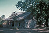 |
January 11, 1974 (#74001968) |
At Mary's Corner, 11 mi. S of Chehalis on Jackson Hwy. 46°32′32″N 122°49′13″W / 46.542222°N 122.820278°W | Chehalis | |
| 15 | La Wis Wis Guard Station No. 1165 |  |
April 8, 1986 (#86000813) |
Gifford Pinchot National Forest 46°40′36″N 121°35′00″W / 46.676667°N 121.583333°W | Packwood | |
| 16 | O. B. McFadden House |  |
April 1, 1975 (#75001861) |
1639 Chehalis Ave. 46°39′29″N 122°57′54″W / 46.658056°N 122.965°W | Chehalis | |
| 17 | Mineral Log Lodge | 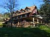 |
March 26, 1975 (#75001862) |
E side of Mineral Lake on Hill Rd. 46°43′20″N 122°10′52″W / 46.722222°N 122.181111°W | Mineral | |
| 18 | Mount Rainier National Park |  |
February 18, 1997 (#97000344) |
Longmire 46°52′59″N 121°53′04″W / 46.883056°N 121.884444°W | Mount Rainier National Park | The park is a National Historic Landmark District, which includes 165 contributing structures and buildings.[6] |
| 19 | Lewis County Courthouse |  |
August 18, 2014 (#14000501) |
351 NW North St. 46°39′42″N 122°58′10″W / 46.661715°N 122.969327°W | Chehalis | |
| 20 | Longmire Buildings |  |
May 28, 1987 (#87001338) |
Longmire 46°45′06″N 121°48′42″W / 46.751667°N 121.811667°W | Mount Rainier National Park | Extends into Pierce County |
| 21 | Longmire Campground Comfort Station No. L-302 |  |
March 13, 1991 (#91000209) |
Longmire 46°44′47″N 121°48′41″W / 46.746303°N 121.811442°W | Mount Rainier National Park | |
| 22 | Longmire Campground Comfort Station No. L-303 |  |
March 13, 1991 (#91000210) |
Longmire 46°44′41″N 121°48′41″W / 46.744861°N 121.811344°W | Mount Rainier National Park | |
| 23 | Longmire Campground Comfort Station No. L-304 | March 13, 1991 (#91000211) |
Longmire 46°44′36″N 121°48′44″W / 46.74325°N 121.812164°W | Mount Rainier National Park | Extends into Pierce County | |
| 24 | Longmire Historic District |  |
March 13, 1991 (#91000173) |
Longmire 46°44′59″N 121°48′45″W / 46.749722°N 121.8125°W | Mount Rainier National Park | |
| 25 | Narada Falls Bridge | 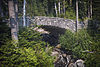 |
March 13, 1991 (#91000197) |
Paradise 46°46′31″N 121°44′43″W / 46.775292°N 121.745181°W | Mount Rainier National Park | |
| 26 | Narada Falls Comfort Station | 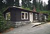 |
March 13, 1991 (#91000208) |
Paradise 46°46′33″N 121°44′40″W / 46.775825°N 121.744514°W | Mount Rainier National Park | |
| 27 | North Fork Guard Station No. 1142 |  |
April 11, 1986 (#86000815) |
Gifford Pinchot National Forest 46°27′12″N 121°47′13″W / 46.453389°N 121.786896°W | Randle vicinity | |
| 28 | Ohanapecosh Comfort Station No. O-302 |  |
March 13, 1991 (#91000203) |
Mt. Rainier National Park 46°44′13″N 121°33′53″W / 46.736944°N 121.564722°W | Ohanapecosh | |
| 29 | Ohanapecosh Comfort Station No. O-303 |  |
March 13, 1991 (#91000204) |
Mt. Rainier National Park 46°44′10″N 121°34′01″W / 46.736111°N 121.566944°W | Ohanapecosh | |
| 30 | Ben Olsen House |  |
November 7, 1976 (#76001897) |
S end of D St. 46°23′48″N 122°57′16″W / 46.396667°N 122.954444°W | Vader | |
| 31 | Olympic Club Saloon |  |
March 10, 1980 (#80004006) |
112 N. Tower St. 46°43′01″N 122°57′06″W / 46.716944°N 122.951667°W | Centralia | |
| 32 | O. K. Palmer House | 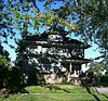 |
May 15, 1986 (#86001067) |
673 N.W. Pennsylvania 46°40′03″N 122°58′31″W / 46.6675°N 122.975278°W | Chehalis | |
| 33 | Pennsylvania Avenue-West Side Historic District |  |
December 3, 1991 (#91001721) |
600 block NW. St. Helens and 440-723 Pennsylvania Aves. 46°39′57″N 122°58′30″W / 46.665833°N 122.975°W | Chehalis | |
| 34 | Randle Ranger Station-Work Center |  |
April 8, 1986 (#86000816) |
Gifford Pinchot National Forest 46°32′08″N 121°57′28″W / 46.535556°N 121.957778°W | Randle | |
| 35 | Scout Lodge |  |
September 15, 2004 (#04001007) |
278 SE Adams Ave. 46°39′47″N 122°57′34″W / 46.663056°N 122.959444°W | Chehalis | |
| 36 | St. Helens Hotel |  |
October 8, 1991 (#91001497) |
440 N. Market Blvd. 46°39′53″N 122°58′02″W / 46.664722°N 122.967222°W | Chehalis | |
| 37 | The Sentinel |  |
December 17, 1991 (#91001782) |
Washington Park, bounded by Main, Pearl, Locust and Silver 46°42′59″N 122°57′19″W / 46.716389°N 122.955278°W | Centralia | Sculptor — Alonzo Victor Lewis |
| 38 | Three Lakes Patrol Cabin | 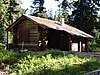 |
March 13, 1991 (#91000189) |
Mt. Rainier National Park 46°45′51″N 121°28′21″W / 46.764167°N 121.4725°W | Ohanapecosh | |
| 39 | U.S. Post Office – Centralia Main |  |
August 7, 1991 (#91000640) |
214 W. Centralia College Blvd.[7] 46°42′56″N 122°57′25″W / 46.7156°N 122.9570°W | Centralia | |
| 40 | U.S. Post Office – Chehalis Main | 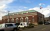 |
May 30, 1991 (#91000641) |
225 NW Cascade Ave.[8] 46°39′47″N 122°57′59″W / 46.663056°N 122.966389°W | Chehalis | |
| 41 | Wolfenbarger Site | May 2, 1977 (#77001346) |
Address Restricted | Curtis |
Former listings edit
| [3] | Name on the Register | Image | Date listed | Date removed | Location | City or town | Description |
|---|---|---|---|---|---|---|---|
| 1 | Doty Bridge | July 16, 1982 (#82004260) | July 16, 1990 | Spanning the Chehalis River | Doty | One of the last remaining covered railroad bridges in Washington state, it was originally a 1924 prefabricated structure and rebuilt in 1926.[9] | |
| 2 | Weyerhaeuser Pe Ell Bridge | 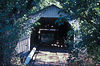 |
July 16, 1982 (#82004261) | July 16, 1990 | South of Pe Ell, spanning the Chehalis River | Pe Ell | Covered wooden bridge carrying a logging company water main over the Chehalis River. The bridge was washed away during the December 2007 flood. |
See also edit
References edit
Wikimedia Commons has media related to National Register of Historic Places in Lewis County, Washington.
- ^ The latitude and longitude information provided in this table was derived originally from the National Register Information System, which has been found to be fairly accurate for about 99% of listings. Some locations in this table may have been corrected to current GPS standards.
- ^ National Park Service, United States Department of the Interior, "National Register of Historic Places: Weekly List Actions", retrieved April 12, 2024.
- ^ a b Numbers represent an alphabetical ordering by significant words. Various colorings, defined here, differentiate National Historic Landmarks and historic districts from other NRHP buildings, structures, sites or objects.
- ^ "National Register Information System". National Register of Historic Places. National Park Service. April 24, 2008.
- ^ The eight-digit number below each date is the number assigned to each location in the National Register Information System database, which can be viewed by clicking the number.
- ^ "Mount Rainier Historic Structures". Retrieved 2008-02-23.
- ^ Address based on USPS website. Accessed April 12, 2016.
- ^ Address based on USPS website. Accessed April 12, 2016.
- ^ Hoxit, Eric (February 19, 1976). "Will old covered bridge find new home at fair?". The Daily Chronicle. p. 1. Retrieved April 18, 2024.