
KNOWPIA
WELCOME TO KNOWPIA

National Register of Historic Places listings in Suwannee County, Florida 
Summary
This is a list of the National Register of Historic Places listings in Suwannee County, Florida.
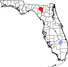
This is intended to be a complete list of the properties on the National Register of Historic Places in Suwannee County, Florida, United States. The locations of National Register properties for which the latitude and longitude coordinates are included below, may be seen in a map.[1]
There are 7 properties listed on the National Register in the county.
This National Park Service list is complete through NPS recent listings posted April 12, 2024.[2]
| Alachua - Baker - Bay - Bradford - Brevard - Broward - Calhoun - Charlotte - Citrus - Clay - Collier - Columbia - DeSoto - Dixie - Duval - Escambia - Flagler - Franklin - Gadsden - Gilchrist - Glades - Gulf - Hamilton - Hardee - Hendry - Hernando - Highlands - Hillsborough (Tampa) - Holmes - Indian River - Jackson - Jefferson - Lafayette - Lake - Lee - Leon - Levy - Liberty - Madison - Manatee - Marion - Martin - Miami-Dade (Miami) - Monroe - Nassau - Okaloosa - Okeechobee - Orange - Osceola - Palm Beach - Pasco - Pinellas - Polk - Putnam - St. Johns - St. Lucie - Santa Rosa - Sarasota - Seminole - Sumter - Suwannee - Taylor - Union - Volusia - Wakulla - Walton - Washington |
Current listings edit
| [3] | Name on the Register[4] | Image | Date listed[5] | Location | City or town | Description |
|---|---|---|---|---|---|---|
| 1 | George Allison House |  |
April 20, 1995 (#95000369) |
418 West Duval Street 30°18′01″N 82°59′19″W / 30.300278°N 82.988611°W | Live Oak | |
| 2 | Bishop B. Blackwell House |  |
February 28, 1985 (#85000360) |
110 Parshley Street 30°17′38″N 82°59′11″W / 30.293889°N 82.986389°W | Live Oak | |
| 3 | Hull-Hawkins House |  |
May 7, 1973 (#73000604) |
10 miles south of Live Oak on State Road 49 30°11′07″N 82°54′13″W / 30.185278°N 82.903611°W | Live Oak | |
| 4 | Old Live Oak City Hall | 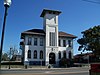 |
April 24, 1986 (#86000862) |
212 North Ohio Avenue 30°17′50″N 82°59′00″W / 30.297222°N 82.983333°W | Live Oak | |
| 5 | Dr. Price House |  |
September 25, 1998 (#98001200) |
702 Pine Avenue 30°17′28″N 82°58′43″W / 30.291111°N 82.978611°W | Live Oak | |
| 6 | Suwannee County Courthouse | 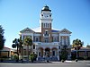 |
November 12, 1998 (#98001349) |
200 South Ohio Avenue 30°17′44″N 82°59′05″W / 30.295556°N 82.984722°W | Live Oak | |
| 7 | Union Depot and Atlantic Coast Line Freight Station | 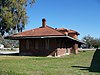 |
April 24, 1986 (#86000860) |
200 block of North Ohio Avenue 30°17′49″N 82°59′01″W / 30.296944°N 82.983611°W | Live Oak |
See also edit
Wikimedia Commons has media related to National Register of Historic Places in Suwannee County, Florida.
References edit
- ^ The latitude and longitude information provided in this table was derived originally from the National Register Information System, which has been found to be fairly accurate for about 99% of listings. Some locations in this table may have been corrected to current GPS standards.
- ^ National Park Service, United States Department of the Interior, "National Register of Historic Places: Weekly List Actions", retrieved April 12, 2024.
- ^ Numbers represent an alphabetical ordering by significant words. Various colorings, defined here, differentiate National Historic Landmarks and historic districts from other NRHP buildings, structures, sites or objects.
- ^ "National Register Information System". National Register of Historic Places. National Park Service. March 13, 2009.
- ^ The eight-digit number below each date is the number assigned to each location in the National Register Information System database, which can be viewed by clicking the number.