
KNOWPIA
WELCOME TO KNOWPIA

National Register of Historic Places listings in Wyandot County, Ohio 
Summary
This is a list of the National Register of Historic Places listings in Wyandot County, Ohio.

This is intended to be a complete list of the properties and districts on the National Register of Historic Places in Wyandot County, Ohio, United States. The locations of National Register properties and districts for which the latitude and longitude coordinates are included below, may be seen in a Google map.[1]
There are 10 properties and districts listed on the National Register in the county.
This National Park Service list is complete through NPS recent listings posted April 12, 2024.[2]
Current listings edit
| [3] | Name on the Register[4] | Image | Date listed[5] | Location | City or town | Description |
|---|---|---|---|---|---|---|
| 1 | Armstrong Farm | 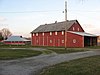 |
January 17, 1986 (#86000070) |
13706 State Route 199 40°47′48″N 83°15′53″W / 40.796667°N 83.264722°W | Crane Township | |
| 2 | Col. Crawford Burn Site Monument |  |
April 15, 1982 (#82003667) |
Northeast of Crawford 40°55′23″N 83°20′04″W / 40.923056°N 83.334444°W | Crawford Township | 1877-built monument, at site of 1782 burning at the stake of Col. Crawford |
| 3 | Indian Mill | 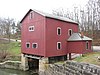 |
November 10, 1970 (#70000525) |
3.5 miles northeast of Upper Sandusky on a Crane Township road 40°51′47″N 83°15′15″W / 40.863056°N 83.254167°W | Crane Township | |
| 4 | Parker Covered Bridge | 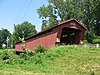 |
March 31, 1975 (#75001558) |
5 miles northeast of Upper Sandusky on Township Road 40A 40°54′11″N 83°14′41″W / 40.903056°N 83.244722°W | Crane Township | |
| 5 | South Sandusky Avenue Historic District | 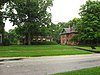 |
October 22, 1980 (#80003248) |
S. Sandusky Ave. 40°49′18″N 83°16′53″W / 40.821667°N 83.281389°W | Upper Sandusky | |
| 6 | Swartz Covered Bridge |  |
October 8, 1976 (#76001553) |
Northwest of Wyandot on County Road 130 40°46′14″N 83°10′09″W / 40.770556°N 83.169167°W | Antrim Township | |
| 7 | William Walker Jr. House | 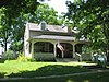 |
March 11, 1980 (#80003249) |
132-134 N. 4th St. 40°49′44″N 83°16′42″W / 40.828889°N 83.278333°W | Upper Sandusky | |
| 8 | West End Elementary School |  |
November 5, 1987 (#87001989) |
200 West St. 40°57′06″N 83°23′13″W / 40.951667°N 83.386944°W | Carey | |
| 9 | Wyandot County Courthouse and Jail |  |
July 2, 1973 (#73001553) |
Courthouse Sq. 40°49′37″N 83°16′50″W / 40.826944°N 83.280556°W | Upper Sandusky | |
| 10 | Wyandot Mission Church | 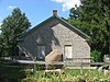 |
January 20, 1976 (#76001552) |
Northern side of Upper Sandusky off Church St. 40°50′10″N 83°16′41″W / 40.836111°N 83.278194°W | Upper Sandusky |
See also edit
Wikimedia Commons has media related to National Register of Historic Places in Wyandot County, Ohio.
- List of National Historic Landmarks in Ohio
- Listings in neighboring counties: Crawford, Hancock, Hardin, Marion, Seneca
- National Register of Historic Places listings in Ohio
References edit
- ^ The latitude and longitude information provided in this table was derived originally from the National Register Information System, which has been found to be fairly accurate for about 99% of listings. Some locations in this table may have been corrected to current GPS standards.
- ^ National Park Service, United States Department of the Interior, "National Register of Historic Places: Weekly List Actions", retrieved April 12, 2024.
- ^ Numbers represent an alphabetical ordering by significant words. Various colorings, defined here, differentiate National Historic Landmarks and historic districts from other NRHP buildings, structures, sites or objects.
- ^ "National Register Information System". National Register of Historic Places. National Park Service. April 24, 2008.
- ^ The eight-digit number below each date is the number assigned to each location in the National Register Information System database, which can be viewed by clicking the number.