


Summary
Srirampore subdivision is an administrative subdivision of the Hooghly district in the state of West Bengal, India.
Srirampore subdivision
শ্রীরামপুর মহকুমা | |
|---|---|
Subdivision | |
| Serampore subdivision | |
 | |
| Coordinates: 22°45′N 88°20′E / 22.75°N 88.34°E | |
| Country | |
| State | West Bengal |
| District | Hooghly |
| Headquarters | Serampore |
| Government | |
| • Type | Subdivisional headquarter |
| Area | |
| • Total | 422.45 km2 (163.11 sq mi) |
| Population | |
| • Total | 1,469,849 |
| • Density | 3,500/km2 (9,000/sq mi) |
| Languages | |
| • Official | Bengali, English |
| Time zone | UTC+5:30 (IST) |
| ISO 3166 code | ISO 3166-2:IN |
| Vehicle registration | WB 15 / WB 16 / WB 17 / WB 18 |
| Website | wb |
Overview edit
Srirampore subdivision is the most urbanised, with the highest density of population, of all the subdivisions of Hooghly district. Urbanisation started with industrialisation of the Hooghly Flats, the narrow strip of land along the Hooghly and spread inland covering a large portion of Hooghly-Damodar Plain, the agriculturally rich alluvial plains lying between the Hooghly and the Damodar. The entire area is a part of the Gangetic Delta. The Hooghly is a tidal river and has a high west bank. The spread of urbanisation obviously affected the livelihood of the people, with a high proportion of workers being engaged in non-agricultural pursuits.[1][2]
Subdivisions edit
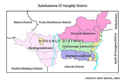
The Hooghly district is divided into the following administrative subdivisions:[3]

| Subdivision | Headquarters | Area km2 |
Population (2011) |
Rural Population % (2011) |
Urban Population % (2011) |
|---|---|---|---|---|---|
| Chinsurah | Hugli-Chuchura | 1,148.15 | 1,657,518 | 68.63 | 31.37 |
| Chandannagore | Chandannagar | 508.08 | 1,127,176 | 58.52 | 41.48 |
| Srirampore | Serampore | 422.45 | 1,469,849 | 26.88 | 73.12 |
| Arambag | Arambag | 1,058.87 | 1,264,602 | 94.77 | 5.23 |
| Hooghly district | Chinsurah | 3,149.00 | 5,519,145 | 61.43 | 38.57 |


3miles
M: municipal city/ town, CT: census town, R: rural/ urban centre,
Owing to space constraints in the small map, the actual locations in a larger map may vary slightly


3miles
River
Rajyadharpur
M: municipal city/ town, CT: census town,
Owing to space constraints in the small map, the actual locations in a larger map may vary slightly
Administrative units edit
Srirampore subdivision has 7 police stations, 4 community development blocks, 4 panchayat samitis, 34 gram panchayats, 240 mouzas, 208 inhabited villages, 6 municipalities and 34 census towns. The municipalities are Uttarpara-Kotrung, Konnagar, Serampore, Baidyabati, Rishra and Dankuni. The census towns are: Belumilki, Dakshin Rajyadharpur, Rishra, Bamunari, Nawapara, Nabagram Colony, Basai, Kanaipur, Raghunathpur, Masat, Jangalpara, Gangadharpur, Manirampur, Dudhkalmi, Nababpur, Kumirmora, Ramanathpur, Bhagabatipur, Kharsarai, Tisa, Kapashanria, Jaykrishnapur, Purba Tajpur, Begampur, Baksa, Panchghara, Chikrand, Janai, Pairagachha, Naity (Naiti), Barijhati, Garalgachha, Krishnapur and Rajbalhat. The subdivision has its headquarters at Serampore.[4][5]
Kolkata Urban Agglomeration edit
The following Municipalities and Census Towns in Srirampur subdivision were part of Kolkata Urban Agglomeration in the 2011 census: Serampore (M), Baidyabati (M), Rishra (M), Konnagar (M), Uttarpara Kotrung (M), Rishra (CT), Bamunari (CT), Dakshin Rajyadharpur (CT), Nabagram Colony (CT), Raghunathpur (PS-Dankuni) (CT) and Kanaipur (CT).[6]
Police stations edit
Police stations in Srirampore subdivision have the following features and jurisdiction:[7][8]
| Police station | Area covered km2 |
Municipal town | CD Block |
|---|---|---|---|
| Jangipara | n/a | - | Jangipara |
| Chanditala | n/a | - | Chanditala I, Chanditala II (partly) |
| Dankuni | n/a | Dankuni | Chanditala II (partly), Sreerampur Uttarpara (partly) |
| Uttarpara | n/a | Uttarpara-Kotrung, Konnagar | Sreerampur Uttarpara (partly) |
| Serampore | n/a | Serampore, Baidyabati | Sreerampur Uttarpara (partly) |
| Serampore Women | n/a | n/a | n/a |
| Rishra | n/a | Rishra | - |
Blocks edit
Community development blocks in Srirampore subdivision are:[3][9]

| CD Block | Headquarters | Area km2 |
Population (2011) |
SC % | ST % | Hindus % | Muslims % | Literacy Rate % |
Census Towns |
|---|---|---|---|---|---|---|---|---|---|
| Sreerampur Uttarpara | Serampore | 44.80 | 152,266 | 23.04 | 0.82 | 90.14 | 9.10 | 86.68 | 9 |
| Chanditala I | Masat | 93.45 | 179,825 | 19.60 | 0.16 | 65.23 | 34.60 | 83.76 | 9 |
| Chanditala II | Chanditala | 70.34 | 158,396 | 15.21 | 1.00 | 81.35 | 18.41 | 84.78 | 15 |
| Jangipara | Jangipara | 164.23 | 221,578 | 30.87 | 4.61 | 76.41 | 23.15 | 79.62 | 1 |
Map of serampore subdivision edit

BLOCK MAP edit
-
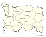 JANGIPARA CD BLOCK
 -
 CHANDITALA-I CD BLOCK
 -
 CHANDITALA-II CD BLOCK
 -
 SREERAMPUR UTTARPARA CD BLOCK


Economy edit
Industry edit
The first jute mill in India was set up at Rishra in 1855.[10] Hastings Jute Mill, established in 1875, in what was the country retreat of Warren Hastings, on the banks of the Hooghly at Rishra is owned by Sanjay Kajaria, MD of Murlidhar Ratanlal Exports.[11] Another jute mill at Rishra, the Wellington Jute Mill, stopped operations in 2016.[12] India Jute Mill at Serampore, established in 1866, also stopped working from 2015.[13][14]
There are several large and varied industrial units in Srirampore subdivision:
- The manufacturing activities of ICI India Limited commenced in 1939 with the setting up of Alkali and Chemical Corporation of India at Rishra. The plant manufactures paints and special chemicals. AkzoNobel, a Dutch multinational, acquired the parent company in UK, Imperial Chemical Industries, in 2008.[15]
- Hindustan National Glass & Industries Ltd., was founded by C.K.Somany in 1946, with the commissioning of India's first fully automated glass manufacturing plant, at Rishra. It is a key player in India's container glass industry.[16]
- Jaya Shree Textiles Limited, a unit of Aditya Birla Nuvo Ltd. was established at Rishra in 1949. It is a leading player in the linen and wool segment and a major exporter.[17]
- Kusum Products Ltd. manufactures vanaspati, soap and detergents at Rishra.[18]
- Aditya Birla Insulators, the largest Indian manufacturers of high voltage porcelain insulators, has one its two plants at PO Prabhas Nagar, Rishra. It caters to the entire spectrum of substation and transmission insulators. It exports to over 58 countries.[19]
- Berger Paints India Ltd., the second largest paint company in India, has its headquarters at Kolkata and 10 manufacturing units spread across the country. It has a water based paint plant at Rishra.[20][21]
- PMC Rubber Chemicals India Private Ltd. is a global developer and manufacturer of performance chemicals and plastics. They started in 1994 and have their plant at Rishra.[22][23]
- The Phosphate Company Limited which manufactures and markets the super phosphate fertiliser under the Lakshmi brand, started production at Rishra in 1950. It is one of the leading brands in the market.[24][25]
- United Spirits produces fast moving brands of Indian-made foreign liquor at Bhadrakali.[26][27]
- Bhusan Industries Ltd. has set up a 1.5 lakh tons cold rolling mills complex near Rishra. It started production in 2000.[28]
- Hooghly Alloy & Steels Co. Pvt. Ltd. was established in 1985 and have a 60,000 tonnes per annum rolling mills at Dakshin Rajyadharpur.[29]
- Shalimar Wires Industry Limited was initially set up in 1961 at Uttarpara to provide import substitution support for the Indian paper industry. In the eighties it diversified into import substitution items for the tool room industry and synthetic forming fabric.[30]
- Madura Coats Pvt. Ltd. established a factory at Battala, Serampore in 1889 to produce cotton and blended yarns and industrial products.[31][32]
- Bhusan Power and Steel started with a cold rolling and galvanising plants in 2001 at Bangihati, Mallickpara, Dankuni and have subsequently expanded.[33]
- Dankuni Coal Complex, operated by South Eastern Coalfields, at Dankuni, produces 1,000 MT per day of solid smokeless fuel branded as CILCOKE, 18 million cft per day of coalgas for supply in and around Kolkata and Howrah, tar chemicals etc.[34]
- Diesel Locomotive Component Factory of the Indian Railways was inaugurated by Mamata Banerjee at Dankuni in 2012. It produces high horse power diesel locomotive underframes etc. It functions as a sister unit of Banaras Locomotive Works at Varanasi.[35][36][37]
- Electric Loco Assembly and Ancillary Unit of Chittaranjan Locomotive Works of Indian Railways at Dankuni has started functioning in 2016.[38][39][40]
The entire area has a large number of medium and small industries.[41]
Hindustan Motors started operations at Hindmotor, a neighbourhood in Uttarpara Kotrung Municipality in 1948. The Ambassador was the best known amongst its models.[42] It declared suspension of work at its Uttarpara plant on 24 May 2014.[43]
The jute industry, once the pioneer in industrialising this state, has been in a bad shape, but it is not the jute industry alone that is in a bad shape. In the Srirampore subdivision, there are other units such as J.K.Steel and Bangalaxmi Cotton Mills, which have not been doing well or have closed down, although many other industries are doing well.[44][45]
Srirampore subdivision has a large migrant presence in the workforce. They have come from Bihar, Uttar Pradesh, Orissa and Andhra Pradesh. They have settled in the slums around or near their work place and many of the locality names reflect their origins – Chhapra basti, Gayapar basti, Odiya basti and Telengipara.[46]
Handloom weaving edit
The handloom sarees of Dhaniakhali, Begampur, Jangipara, Rajbalhat areas and dhutis of Haripal, Rajbalhat, Khanakul areas of Hooghly district are widely familiar.[47]
Agriculture edit
Hooghly is an agriculturally prosperous district of West Bengal. Although the economy has been shifting away from agriculture, it is still the pre-dominant economic activity and the main source of livelihood for the rural people of the district. One third of the district income comes from agriculture.[48] Given below is an overview of the agricultural production (all data in tonnes) for Srirampore subdivision, other subdivisions and the Hooghly district, with data for the year 2013-14.[49]
| CD Block/ Subdivision | Rice | Wheat | Jute | Pulses | Oil seeds | Potatoes | Sugarcane |
|---|---|---|---|---|---|---|---|
| Jangipara | 109,389 | - | 30,806 | - | 4,421 | 342,597 | 305 |
| Chanditala I | 10,600 | - | 4,282 | 7 | 261 | 51,925 | - |
| Chanditala II | 5,721 | - | 3,637 | 2 | 1,828 | 39,004 | - |
| Sreerampur Uttarpara | 1,142 | 11 | 1,095 | 3 | 1,548 | 2,585 | 2,132 |
| Srirampore subdivision | 126,852 | 11 | 39,820 | 12 | 8,058 | 436,111 | 2,437 |
| Chinsurah subdivision | 235,561 | 92 | 111,218 | 4 | 10,362 | 812,808 | 162 |
| Chandannagore subdivision | 189,791 | 12 | 136,276 | - | 6,522 | 313,692 | - |
| Arambag subdivision | 255,011 | 75 | 134,541 | 30 | 19,477 | 514,903 | 123,934 |
| Hooghly district | 807,215 | 190 | 421,855 | 46 | 44,419 | 2,077,514 | 126,533 |
Poverty edit
The information given above leads us on to a comment in the District Human Development Report for Hooghly district: In the sub-division wise comparison of the levels of poverty in Hooghly district, Srirampur and Chandannagore share the lowest incidence of poverty.[50]
Education edit
Hooghly district had a literacy rate of 81.80% as per the provisional figures of the census of India 2011. Chinsurah subdivision had a literacy rate of 79.17%, Chandannagore subdivision 83.01%, Srirampore subdivision 86.13% and Arambag subdivision 79.05. [51]
Given in the table below (data in numbers) is a comprehensive picture of the education scenario in Hooghly district for the year 2013-14:[51]
| Subdivision | Primary School |
Middle School |
High School |
Higher Secondary School |
General College, Univ |
Technical / Professional Instt |
Non-formal Education | |||||||
|---|---|---|---|---|---|---|---|---|---|---|---|---|---|---|
| Institution | Student | Institution | Student | Institution | Student | Institution | Student | Institution | Student | Institution | Student | Institution | Student | |
| Chinsurah | 899 | 85,213 | 46 | 3,885 | 98 | 48,722 | 109 | 124,068 | 7 | 16,342 | 26 | 10,564 | 2,413 | 45,289 |
| Chandannagore | 606 | 53,382 | 32 | 3,312 | 46 | 22,000 | 77 | 89,132 | 6 | 20,450 | 6 | 778 | 1,297 | 29,127 |
| Srirampore | 577 | 64,207 | 25 | 3,611 | 65 | 37,997 | 97 | 108,199 | 8 | 16,631 | 3 | 793 | 1,337 | 33,060 |
| Arambag | 935 | 80,705 | 49 | 5,462 | 83 | 48,513 | 76 | 91,911 | 7 | 16,950 | 3 | 228 | 1,838 | 57,383 |
| Hooghly district | 3,013 | 283,407 | 152 | 16,270 | 292 | 157,232 | 359 | 413,310 | 28 | 70,373 | 38 | 12,363 | 6,885 | 164,859 |
Note: Primary schools include junior basic schools; middle schools, high schools and higher secondary schools include madrasahs; technical schools include junior technical schools, junior government polytechnics, industrial technical institutes, industrial training centres, nursing training institutes etc.; technical and professional colleges include engineering colleges, medical colleges, para-medical institutes, management colleges, teachers training and nursing training colleges, law colleges, art colleges, music colleges etc. Special and non-formal education centres include sishu siksha kendras, madhyamik siksha kendras, centres of Rabindra mukta vidyalaya, recognised Sanskrit tols, institutions for the blind and other handicapped persons, Anganwadi centres, reformatory schools etc.[51]
The following institutions are located in Srirampore subdivision:
- Serampore College, a general degree college, was established in 1818 by William Carey, Joshua Marshman and William Ward at Serampore, which was a Danish colony from 1755 to 1845.[52]
- Pearl Rosary School, affiliated to WBBSE, WBCHSE, was established at Serampore in 2005. The school is authorised study centre of National Institute of Open Schooling ( NIOS), Govt of India.
- Raja Peary Mohan College, a general degree college, was established at Uttarpara in 1887.[53]
- Serampore Girls' College, a general degree college for girls, was established at Serampore in 1981.[54]
- Government College of Engineering & Textile Technology Serampore, an engineering college, was established in 1908 as Government Central Weaving Institute. It started offering a degree course in textile technology in 1957. It started offering B. Tech. in 1998, and added general engineering subjects. It started offering M.Tech. courses from 1994.[55]
- Nabagram Hiralal Paul College, a general degree college, was established in 1957, at Nabagram, Konnagar.[56]
- Bidhan Chandra College, Rishra, a general degree college, was established at Rishra in 1957.[57]
- Mahitosh Nandy Mahavidyalaya, a general degree college, was established at Jangipara, in 2007.[58][59]
- Vidyasagar Mahavidyalaya, a general degree college, was established at Suchia, Masat in 1998.[60]
- Swami Niswambalananda Girls' College, a general degree college for girls, was established at Bhadrakali in 1978.[61]
Healthcare edit
The table below (all data in numbers) presents an overview of the medical facilities available and patients treated in the hospitals, health centres and sub-centres in 2014 in Hooghly district.[62]
| Subdivision | Health & Family Welfare Deptt, WB | Other State Govt Deptts |
Local bodies |
Central Govt Deptts / PSUs |
NGO / Private Nursing Homes |
Total | Total Number of Beds |
Total Number of Doctors* |
Indoor Patients |
Outdoor Patients | |||
|---|---|---|---|---|---|---|---|---|---|---|---|---|---|
| Hospitals |
Rural Hospitals |
Block Primary Health Centres |
Primary Health Centres | ||||||||||
| Chinsurah | 1 | 2 | 3 | 24 | - | - | - | 31 | 61 | 1,091 | 108 | 94,213 | 1,830,358 |
| Chandannagore | 1 | 3 | - | 8 | - | - | - | 41 | 53 | 828 | 56 | 70,724 | 1,105,060 |
| Srirampore | 3 | 2 | 2 | 12 | - | - | - | 80 | 99 | 1,894 | 85 | 63,619 | 1,252,941 |
| Arambag | 1 | 1 | 5 | 16 | - | - | - | 35 | 58 | 919 | 57 | 83,469 | 1,743,719 |
| Hooghly district | 6 | 8 | 10 | 60 | - | - | - | 187 | 271 | 4,732 | 306 | 312,025 | 5,932,078 |
.* Excluding nursing homes
Medical facilities in Srirampore subdivision are as follows:
Hospitals: (Name, location, beds)[63]
Serampore Walsh Super Speciality Subdivisional Hospital, Serampore Municipality, 266 beds
Serampore TB Hospital, Serampore Municipality, 55 beds.
Serampore ESI Hospital, Serampore Municipality, 216 beds.
Uttarpara General Hospital, Uttarpara Kotrung Municipality, 204 beds
Female Vagrants Home, Uttarpara Kotrung Municipality.
Konnagar Matri Sadan O Sishu Mangal Pratisthan, Konnagar Municipality, 43 beds.
Rishra Municipal Seva Sadan, Rishra Municipality, 150 beds.
Rural Hospitals: (Name, block, location, beds) [63]
Jangipara Rural Hospital, Jangipara CD Block, Jangipara, 60 beds.
Akuni Ichhapasar Rural Hospital, Chanditala I CD Block, Aniya, 30 beds.
Chanditala Rural Hospital, Chanditala II CD Block, Chanditala, 30 beds.
Kanaipur Rural Hospital, Sreerampur Uttarpara CD Block, Kanaipur, 30 beds.
Primary Health Centres (CD Block-wise)(CD Block, PHC location, beds)[63]
Jangipara CD Block: Mundalika (10 beds), Furfura (10 beds), Guti (4 beds), Rajbalhat (6 beds).
Chanditala I CD Block: Bhattapur, Akuni (4 beds), Gangadharpur (10 beds), Jangalpara (6 beds).
Chanditala II CD Block:Begampur (4 beds), Janai Baksa, Janai (10 beds).
Sreerampur Uttarpara CD Block: Rajyadharpur (10 beds).
Uttarpara Kotrung Municipality: Bhadrakali (5 beds).
Private Hospitals:* (Name, location, beds)[64]
Paramount Health Care, 148 & 151, G.T Road, Maniktala, Serampore, 30 beds,
Disha Eye Hospital, Sheoraphuli, 25 beds
Kamala Ray Hospital Pvt. Ltd., Kotrung GT Road, PO Hindmotor, 50 beds
.* Excluding nursing homes
Electoral constituencies edit
Lok Sabha (parliamentary) and Vidhan Sabha (state assembly) constituencies in Srirampore subdivision were as follows:[65]
| Lok Sabha constituency | Reservation | Vidhan Sabha constituency | Reservation | CD Block and/or Gram panchayats and/or municipal areas |
|---|---|---|---|---|
| Srerampur | None | Uttarpara | None | Uttarpara-Kotrang municipality, Konnagar municipality, Nabagram, Kanaipur and Raghunathpur gram panchayats of Sreerampur Uttarpara community development block |
| - | - | Sreerampur | None | Ward Nos. 3 to 19 and 25 of Serampore municipality, Rishra municipality, Rajyadharpur and Rishra gram panchayats of Sreerampur Uttarpara CD Block |
| - | - | Champdani | None | Champdani municipality, Baidyabati municipality, Ward Nos. 1 & 2 and 20 to 24 of Serampore municipality and Payarapur GP of Sreerampur Uttarpara CD Block |
| - | - | Chanditala | None | Bhagabatipur, Gangadharpur, Krishnarampur, Kumirmora and Nababpur GPs of Chanditala I CD Block and Baksa, Barijhati, Chanditala, Dankuni, Garalgachha, Janai, Monoharpur, Mrigala and Naiti GPs of Chanditala II CD Block |
| - | - | Jangipara | None | Jangipara CD Block and Aniya, Haripur, Masat and Sehakhala GPs of Chanditala I CD Block |
| - | - | Other two assembly segments are in Howrah district | - | - |
References edit
- ^ "District Census Handbook: Hugli, Series-20, Part XIIA" (PDF). Physiography, Page 17-24. Directorate of Census Operations, West Bengal, 2011. Retrieved 19 June 2017.
- ^ "District Human Development Report: Hooghly" (PDF). Occupational break-up of the working people , page 57. Development and Planning Department, Government of West Bengal, 2011. Retrieved 14 June 2017.
- ^ a b "District Statistical Handbook 2014 Hooghly". Table 2.2, 2.4(a). Department of Statistics and Programme Implementation, Government of West Bengal. Retrieved 6 October 2018.
- ^ "District Statistical Handbook 2014 Hooghly". Table 2.1. Department of Statistics and Programme Implementation, Government of West Bengal. Retrieved 6 October 2018.
- ^ "Directory of District, Subdivision, Panchayat Samiti/ Block and Gram Panchayats in West Bengal". Hooghly - Revised in March 2008. Panchayats and Rural Development Department, Government of West Bengal. Retrieved 19 June 2017.
- ^ "Provisional Population Totals, Census of India 2011" (PDF). Constituents of Urban Agglomeration Having Population Above 1 Lakh. Census of India 2011. Retrieved 16 June 2017.
- ^ "District Statistical Handbook 2014 Hooghly". Tables 2.1, 2.2. Department of Statistics and Programme Implementation, Government of West Bengal. Retrieved 6 October 2018.
- ^ "Hooghly District Police". West Bengal Police. Retrieved 20 June 2017.
- ^ "C.D. Block Wise Primary Census Abstract Data(PCA)". 2011 census: West Bengal – District-wise CD Blocks. Registrar General and Census Commissioner, India. Retrieved 24 October 2016.
- ^ "History of Jute". WorldJute.Com. Retrieved 26 June 2017.
- ^ "Hastings Jute Mill – rich past, fraying future". Jayanta Mallick. The Hindu Business Line. 12 May 2016. Retrieved 26 June 2017.
- ^ "Wellington jute mill stops operation". The Hindu Business Line. 26 March 2016. Retrieved 26 June 2017.
- ^ "Two Jute Mills suspend work – blame on few orders and woekrs". The Telegraph, 8 June 2015. Archived from the original on 8 June 2015. Retrieved 26 June 2017.
- ^ Women and Labour in Late Colonial India – The Bengal Jute Industry. Cambridge University Press. 6 May 1999. p. 15. ISBN 9780521453639. Retrieved 26 June 2017.
{{cite book}}:|work=ignored (help) - ^ "Akzo Nobel India Ltd". Business Standard. Retrieved 26 June 2017.
- ^ "HNGIL". HNGIL. Retrieved 26 June 2017.
- ^ "Jaya Shree Textiles". Aditya Birla Group. Retrieved 26 June 2017.
- ^ "Kusum Products Ltd". Director’s Report, May 2015. The Economic Times, ET Markets. Retrieved 4 July 2017.
- ^ "Aditya Birla Insulators". Aditya Birla Group. Retrieved 4 July 2017.
- ^ "Berger Paints". About us – company profile. Berger Paints. Retrieved 4 July 2017.
- ^ "Berger Paints India Ltd" (PDF). Key Highlights. Crisil Research. Retrieved 4 July 2017.
- ^ "PMC Rubber Chemicals India Pvt. Ltd". PMC Rubber Chemicals. Retrieved 4 July 2017.
- ^ "PMC Rubber Chemicals India Pvt. Ltd". tradeindia.com. Retrieved 4 July 2017.
- ^ "The Phosphate Company Limited". The Phosphate Co. Ltd. Retrieved 4 July 2017.
- ^ "The Phosphate Co. Ltd". tradeindia.com. Retrieved 4 July 2017.
- ^ "United Spirits – Bhadrakali Distillery". Industry About. Retrieved 4 July 2017.
- ^ "Swc to relocate composite distillery". Sourav Majumdar. Business Standard. 8 August 1998. Retrieved 4 July 2017.
- ^ West Bengal Today: 25 years of Economic Development, edited by Raj Kumar Sen and Asish Dasgupta. Deep and Deep Publications Pvt. Ltd. 2007. p. 266. ISBN 9788176299848. Retrieved 26 June 2017.
- ^ "Hooghly Alloy & Steels Co. Pvt. Ltd". HASCO. Retrieved 26 June 2017.
- ^ "Shalimar Wires Industries Limited". Shalimar Wires Industries Limited. Retrieved 4 July 2017.
- ^ "Madura Coats". Money Control. Retrieved 4 July 2017.
- ^ "Madura Coats Pvt. Ltd". Inspirational Articles. 6 June 2012. Retrieved 4 July 2017.
- ^ "Bhusan Power & Steel". Manufacturing Units. Bhusan Power & Steel. Retrieved 4 July 2017.
- ^ "Dankuni Coal Complex". South Eastern Coalfields Ltd. Retrieved 12 July 2017.
- ^ "Mamata inaugurates Dankuni railway factory". The Hindu Business Line, 28 May 2012. 28 May 2012. Retrieved 12 July 2017.
- ^ "Mamata inaugurates diesel locomotive factory". India TV 28 May 2012. 24 June 2013. Retrieved 12 July 2017.
- ^ "Cabinet approves creation of one post of Chief Works Manager in the Mechanical Department on Eastern Railway". PM India. Retrieved 12 July 2017.
- ^ "2016:Various achievements of the Ministry of Railways". 2 January 2017. Political Mirror. Retrieved 12 July 2017.
- ^ "Rlys to appoint consultats for locomotive unit". The Economic Times. The Economic Times, 3 October 2009. 3 October 2009. Retrieved 12 July 2017.
- ^ "Bids opened for procurement of 200 locomotives". Business Standard, 1 July 2015. Retrieved 12 July 2017.
- ^ "Brief Industrial Profile of Hooghly District" (PDF). Large scale industries. MSME Development Institute Kolkata. p. 9. Retrieved 26 June 2017.
- ^ "Hindustan Motors Limited". About Us. Hindmotor. Retrieved 4 June 2016.
- ^ "Hindustan Motors terminates 240 managerial staff". The Indian Express. 7 June 2014. Retrieved 4 June 2016.
- ^ "West Bengal's Jute Industry is Hanging by the Thread". Premankur Biswas. The Indian Express. 29 June 2014. Retrieved 26 June 2017.
- ^ "Industry Falls Sick, Front Suffers". The Telegraph. Archived from the original on 22 October 2004. Retrieved 26 June 2017.
- ^ "Serampore". Prafulla Chakrabarti. Banglapedia. Retrieved 26 June 2017.
- ^ "District Human Development Report: Hooghly" (PDF). page 67. Development and Planning Department, Government of West Bengal, 2011. Retrieved 26 June 2017.
- ^ "District Human Development Report: Hooghly" (PDF). page 58. Development and Planning Department, Government of West Bengal, 2011. Retrieved 26 June 2017.
- ^ "District Statistical Handbook 2014 Hooghly". Tables 18.1. Data for subdivisions/ district calculated by totalling the CD Block data provided. Department of Statistics and Programme Implementation, Government of West Bengal. Retrieved 6 October 2018.
- ^ "District Human Development Report: Hooghly" (PDF). page 90. Development and Planning Department, Government of West Bengal, 2011. Retrieved 26 June 2017.
- ^ a b c "District Statistical Handbook 2014 Hooghly". Basic data: Table 4.4, 4.5, Clarifications: other related tables. Department of Statistics and Programme Implementation, Government of West Bengal. Retrieved 6 October 2018.
- ^ "Serampore College". SC. Retrieved 30 June 2017.
- ^ "Raja Peary Mohan College". RPMC. Retrieved 30 June 2017.
- ^ "Serampore Girls' College". SGC. Retrieved 30 June 2017.
- ^ "Government College of Engineering and Textile Technology". GCETT. Retrieved 30 June 2017.
- ^ "Nabagram Hiralal Paul College". NHPC. Retrieved 30 June 2017.
- ^ "Bidhan Chandra College, Rishra". BCC, Rishra. Retrieved 30 June 2017.
- ^ "Mahitosh Nandy Mahavidyalaya". MNV. Retrieved 30 June 2017.
- ^ "Mahitosh Nandy Mahavidyalaya Hughli". College Search. Retrieved 30 June 2017.
- ^ "Vidyasagar Mahavidyalaya". VM. Retrieved 30 June 2017.
- ^ "Swami Niswabalananda Girls' College". SNGC. Retrieved 30 June 2017.
- ^ "District Statistical Handbook 2014 Hooghly". Table 3.1, 3.3. Department of Statistics and Programme Implementation, Government of West Bengal. Retrieved 6 October 2018.
- ^ a b c "Health & Family Welfare Department". Health Statistics. Government of West Bengal. Retrieved 15 July 2017.
- ^ "Private Hospitals in Hooghly district" (PDF). The list includes Nursing Homes also, but we are giging here only Hospitals. Hooghly district administration. Retrieved 17 July 2017.
- ^ "Delimitation Commission Order No. 18, 15 February 2006" (PDF). West Bengal. Election Commission of India. Retrieved 24 May 2017.