


Summary
The Umatilla Bridge is the collective name for a pair of bridges in the northwest United States, carrying Interstate 82/U.S. Route 395 (I-82/US 395) across the Columbia River at the Washington–Oregon border. The older bridge opened in July 1955 and is a steel through truss cantilever bridge and carries southbound (east on I-82) traffic. Northbound traffic (west on I-82) and pedestrians travel on the newer concrete arch bridge, opened in 1988.
Umatilla Bridge | |
|---|---|
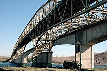 Looking north from Oregon; older bridge in the foreground | |
| Coordinates | 45°55′52″N 119°19′41″W / 45.931°N 119.328°W |
| Carries | |
| Crosses | Columbia River |
| Locale | Benton County, Washington – Umatilla County, Oregon |
| Official name | Interstate 82 Columbia River Bridge |
| Maintained by | Washington State Department of Transportation[1] |
| Characteristics | |
| Design | Through truss cantilever bridge (southbound) Arch bridge (northbound) |
| Material | Steel (southbound) Concrete (northbound) |
| Total length | 3,308 ft (1,008.3 m) (southbound) 3,433 ft (1,046.4 m) (northbound) |
| Width | 27.58 ft (8.4 m) (southbound) |
| Longest span | 600 ft (182.9 m) (southbound) |
| No. of spans | 5 (southbound) 2 (northbound) |
| Clearance above | 16 ft (4.9 m) (southbound) |
| Clearance below | 85 ft (25.9 m) (southbound) 80 ft (24.4 m) (northbound) |
| History | |
| Opened | July 15, 1955 (southbound) 1988 (northbound) |
| Statistics | |
| Daily traffic | 10,800 (2017)[2] |
| Location | |
 | |
History edit
Construction edit
The old bridge was proposed by Umatilla County judge James H. Sturgis and known as "Sturgis' folly" initially. The construction upstream of McNary Dam would create Lake Wallula and submerge the old Wallula Highway. In the interim, traffic was carried across the newly formed lake via ferry service, with 178,576 vehicles transported in 1951.[3] The bridge was dedicated on July 15, 1955, by the governors of Oregon and Washington.[4] The bridge was financed by $10 million worth of bonds and operated as a toll bridge while under county ownership.[5] The tolls were removed on August 30, 1974, and ownership of the bridge was transferred to the states of Oregon and Washington on November 1 of that year following the repayment of bonds.[6][7][8] The Washington State Department of Transportation became the lead agency responsible for maintenance and operating the structure.
The original span was considered for inclusion on the National Register of Historic Places in the early 2000s.[9]
Rehabilitation edit
In June 2017, work began on the rehabilitation of the older steel truss bridge. The bridge had been found to be structurally deficient by the Washington State Department of Transportation and required a two-stage project, beginning with the replacement of the bridge deck at a cost of $11 million.[10] The eastbound bridge was closed and all traffic was moved to the newer westbound bridge, which was reduced to one lane per direction, until work was completed two years later.[11] During the closure, a traffic jam from the August 21, 2017, solar eclipse caused mile-long backups approaching the Columbia River.[12] The second project to repaint the steel truss structure is estimated to cost $40 million and is expected to be funded at a later date.[10]
Description edit
It is a five-span continuous Warren through truss design. The configuration of the span is unusual in the fact that it takes advantage of a submerged island near the middle of the Columbia River. With its two 600-foot (180 m) spans, each constructed using the cantilever method, this is the only bridge in Oregon having two spans constructed using that method.[13]
References edit
- ^ "Asset Management: Bridge Assessment Annual Report" (PDF). The Gray Notebook (34). Washington State Department of Transportation: 20. August 20, 2009. Retrieved December 26, 2023.
- ^ "I-82 (HWY 070) WB over COLUMBIA RIVER". BridgeReports.com. Retrieved January 5, 2023.
- ^ Center for Columbia River History (n.d.). "Document" adapted from Report on A Proposed Highway Bridge Across the Columbia River At Umatilla, Oregon for Umatilla County, Oregon, Benton County, Washington, Oregon Highway Commission, Washington Toll Bridge Authority, September, 1952 (Report). Center for Columbia River History. Archived from the original on May 16, 2008. Retrieved June 24, 2008.
- ^ Orchard, Vance (March 19, 1967). "Umatilla Bridge Was Opened 12 Years Ago". Walla Walla Union-Bulletin. p. 10.
- ^ "Use of Umatilla Bridge Suggested by Governor". Eugene Register-Guard. Associated Press. February 4, 1958. p. 5B – via Google News.
- ^ Boone, Jerry (August 30, 1974). "Now it's Umatilla free bridge". Tri-City Herald. p. 1. Retrieved December 2, 2022 – via Newspapers.com.
- ^ Hiatt, Gene (August 30, 1974). "Two states to take over bridge ownership Nov. 1". Tri-City Herald. p. 24. Retrieved December 2, 2022 – via Newspapers.com.
- ^ Long, Priscilla; Gibson, Elizabeth (February 15, 2007). "Umatilla Bridge spanning the Columbia River opens on April 15, 1955". HistoryLink. Retrieved June 24, 2008.
- ^ Lord, Kristina (July 17, 2001). "Bridges to history: Mid-Columbia bridges considered for National Register of Historic Places". Tri-City Herald. pp. A1–A2.
- ^ a b Culverwell, Wendy (June 9, 2017). "Work starts Monday on $10M Umatilla Bridge repairs". Tri-City Herald. Retrieved June 3, 2019.
- ^ Culverwell, Wendy (June 9, 2019). "This 'structurally deficient' I-82 bridge took 2 years to fix. It's ready to open again". Tri-City Herald. Retrieved December 26, 2023.
- ^ Culverwell, Wendy (August 22, 2017). "Eclipse + bridge work = epic I-82 traffic jam". Tri-City Herald. Retrieved December 26, 2023.
- ^ Federal Highway Administration (November 1, 2006). "Final List of Nationally and Exceptionally Significant Features of the Federal Interstate Highway System". Federal Highway Administration. Retrieved June 24, 2008.
External links edit
- I-82 Columbia River Bridge at Structurae