
KNOWPIA
WELCOME TO KNOWPIA

Williamsburg, Colorado 
Summary
Williamsburg is a statutory town located in Fremont County, Colorado, United States. The town population was 731 at the 2020 census.[5] The Florence post office (ZIP code 81226) serves Williamsburg.[6]
Williamsburg, Colorado | |
|---|---|
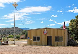 The town hall on John Street, September 2018 | |
 Location of Williamsburg in Fremont County, Colorado. | |
| Coordinates: 38°23′1″N 105°9′37″W / 38.38361°N 105.16028°W | |
| Country | |
| State | |
| County[1] | Fremont County |
| Incorporated | April 7, 1888[2] |
| Government | |
| • Type | Statutory Town[1] |
| Area | |
| • Total | 3.53 sq mi (9.15 km2) |
| • Land | 3.53 sq mi (9.15 km2) |
| • Water | 0.00 sq mi (0.00 km2) |
| Elevation | 5,390 ft (1,643 m) |
| Population | |
| • Total | 731 |
| • Density | 210/sq mi (80/km2) |
| Time zone | UTC-7 (Mountain (MST)) |
| • Summer (DST) | UTC-6 (MDT) |
| ZIP code[6] | 81226 |
| Area code | 719 |
| FIPS code | 08-85155 |
| GNIS feature ID | 0203567 |
| Website | williamsburgcolorado |
Geography edit
Williamsburg is located in southeastern Fremont County at 38°23′1″N 105°9′37″W / 38.38361°N 105.16028°W (38.383623, -105.160337).[7] It is bordered to the east by the city of Florence and to the south by the town of Rockvale. Cañon City, the county seat, is 8 miles (13 km) to the northwest.
According to the United States Census Bureau, Williamsburg has a total area of 3.6 square miles (9.2 km2), all of it land.[8]
Demographics edit
| Census | Pop. | Note | %± |
|---|---|---|---|
| 1900 | 337 | — | |
| 1910 | 556 | 65.0% | |
| 1920 | 402 | −27.7% | |
| 1930 | 155 | −61.4% | |
| 1940 | 97 | −37.4% | |
| 1950 | 65 | −33.0% | |
| 1960 | 57 | −12.3% | |
| 1970 | 75 | 31.6% | |
| 1980 | 72 | −4.0% | |
| 1990 | 253 | 251.4% | |
| 2000 | 714 | 182.2% | |
| 2010 | 662 | −7.3% | |
| 2020 | 731 | 10.4% | |
| U.S. Decennial Census | |||
See also edit
References edit
- ^ a b "Active Colorado Municipalities". State of Colorado, Department of Local Affairs. Archived from the original on December 12, 2009. Retrieved September 1, 2007.
- ^ "Colorado Municipal Incorporations". State of Colorado, Department of Personnel & Administration, Colorado State Archives. December 1, 2004. Retrieved September 2, 2007.
- ^ "2019 U.S. Gazetteer Files". United States Census Bureau. Retrieved July 1, 2020.
- ^ "US Board on Geographic Names". United States Geological Survey. October 25, 2007. Retrieved January 31, 2008.
- ^ a b United States Census Bureau. "Williamsburg town; Colorado". Retrieved April 24, 2023.
- ^ a b "ZIP Code Lookup" (JavaScript/HTML). United States Postal Service. December 14, 2006. Retrieved December 14, 2006.
- ^ "US Gazetteer files: 2010, 2000, and 1990". United States Census Bureau. February 12, 2011. Retrieved April 23, 2011.
- ^ "Geographic Identifiers: 2010 Census Summary File 1 (G001): Williamsburg town, Colorado". American Factfinder. U.S. Census Bureau. Archived from the original on February 13, 2020. Retrieved April 21, 2016.
External links edit
Wikimedia Commons has media related to Williamsburg, Colorado.
- Official website
- Town of Williamsburg contacts
- CDOT map of the Town of Williamsburg