


Summary
The UNESCO (United Nations Educational, Scientific and Cultural Organization) has designated 19 World Heritage Sites in six countries (also called "state parties") of Central and North Asia: Kazakhstan, Kyrgyzstan, Tajikistan, Turkmenistan, Uzbekistan and the Asian part of Russia.[1] The European part of Russia is included in Eastern Europe.[2]
Russia is home to the most inscribed sites with 8 sites, two of which are transborder properties shared with Mongolia in Eastern Asia.[3] The first site from the region was the Itchan Kala in Uzbekistan inscribed in 1990.[4] Each year, UNESCO's World Heritage Committee may inscribe new sites on the list, or delist sites that no longer meet the criteria. Selection is based on ten criteria: six for cultural heritage (i–vi) and four for natural heritage (vii–x).[5] Some sites, designated "mixed sites," represent both cultural and natural heritage. In Northern and Central Asia, there are 11 cultural, 8 natural, and no mixed sites. All of the Russian sites (7) are natural and with the exception of Sayarka, all of the sites in Central Asia are cultural.[6]
The World Heritage Committee may also specify that a site is endangered, citing "conditions which threaten the very characteristics for which a property was inscribed on the World Heritage List." None of the sites in this region has ever been listed as endangered, but possible danger listing has been considered by UNESCO in a number of cases.[7]
Legend edit
- Site; named after the World Heritage Committee's official designation[3]
- Location; at city, regional, or provincial level and geocoordinates
- Criteria; as defined by the World Heritage Committee[5]
- Area; in hectares and acres. If available, the size of the buffer zone has been noted as well. A value of zero implies that no data has been published by UNESCO
- Year; during which the site was inscribed to the World Heritage List
- Description; brief information about the site, including reasons for qualifying as an endangered site, if applicable
World Heritage Sites edit
| Site | Image | Location | Criteria | Area ha (acre) |
Year | Refs |
|---|---|---|---|---|---|---|
| Central Sikhote-Alin | 
|
Primorsky Krai, 45°20′N 136°10′E / 45.333°N 136.167°E |
Natural: (x) |
1,553,928 (3,839,840); buffer zone 65,250 (161,200) | 2001 | [8] |
| Golden Mountains of Altai | 
|
Altai Republic, 50°28′N 86°0′E / 50.467°N 86.000°E |
Natural: (x) |
1,611,457 (3,982,000) | 1998 | [9] |
| Historic Centre of Bukhara | 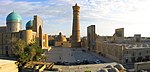
|
Bukhara Region, 39°46′29″N 64°25′43″E / 39.77472°N 64.42861°E |
Cultural: (ii), (iv), (vi) |
—
|
1993 | [10] |
| Historic Centre of Shakhrisyabz | 
|
Qashqadaryo Region, 39°3′0″N 66°50′0″E / 39.05000°N 66.83333°E |
Cultural: (iii), (iv) |
240 (590); buffer zone 82 (200) | 2000 | [11] |
| Itchan Kala | 
|
Khiva, Xorazm Region, 41°22′42″N 60°21′50″E / 41.37833°N 60.36389°E |
Cultural: (iii), (iv), (v) |
26 (64) | 1990 | [12] |
| Kunya-Urgench | 
|
Daşoguz Region, 42°10′59″N 59°5′6″E / 42.18306°N 59.08500°E |
Cultural: (ii), (iii) |
—
|
2005 | [13] |
| Lake Baikal | 
|
Irkutsk Oblast and Republic of Buryatia, 53°10′25″N 107°39′45″E / 53.17361°N 107.66250°E |
Natural: (vii), (viii), (ix), (x) |
8,800,000 (22,000,000) | 1996 | [14] |
| Landscapes of Dauria | 
|
Zabaykalsky Krai, Dornod Province, 49°55′N 115°25′E / 49.917°N 115.417°E |
Natural: (ix), (x) |
912,624 (2,255,140); buffer zone 307,317 (759,400) | 2017 | [15] |
| Lena Pillars Nature Park | 
|
Sakha Republic, 60°40′0″N 127°0′0″E / 60.66667°N 127.00000°E |
Natural: (viii) |
1,272,150 (3,143,600) | 2012 | [16] |
| Mausoleum of Khoja Ahmed Yasawi | 
|
Turkistan, Turkistan Region, 43°17′35″N 68°16′28″E / 43.29306°N 68.27444°E |
Cultural: (i), (iii), (iv) |
0.55 (1.4); buffer zone 88 (220) | 2003 | [17] |
| Natural System of Wrangel Island Reserve | 
|
Chukotka Autonomous Okrug, 71°11′20″N 179°42′55″E / 71.18889°N 179.71528°E |
Natural: (ix), (x) |
916,300 (2,264,000); buffer zone 3,745,300 (9,255,000) | 2004 | [18] |
| Parthian Fortresses of Nisa | 
|
Bagyr settlement, Ruhabat District, Ahal Region, 37°59′59″N 58°11′55″E / 37.99972°N 58.19861°E |
Cultural: (ii), (iii) |
78 (190); buffer zone 400 (990) | 2007 | [19] |
| Petroglyphs within the Archaeological Landscape of Tamgaly | 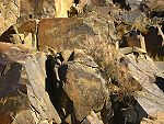
|
Almaty Region, 43°48′12″N 75°32′6″E / 43.80333°N 75.53500°E |
Cultural: (iii) |
900 (2,200); buffer zone 2,900 (7,200) | 2004 | [20] |
| Proto-urban site of Sarazm | 
|
Panjakent, 39°30′28″N 67°27′37″E / 39.50778°N 67.46028°E |
Cultural: (ii), (iii) |
16 (40); buffer zone 142 (350) | 2010 | [21] |
| Putorana Plateau | 
|
Krasnoyarsk Krai, 69°2′49″N 94°9′29″E / 69.04694°N 94.15806°E |
Natural: (vii), (ix) |
1,887,251 (4,663,500); buffer zone 1,773,300 (4,382,000) | 2010 | [22] |
| Samarkand – Crossroads of Cultures | 
|
Samarqand Region, 39°40′7″N 67°0′0″E / 39.66861°N 67.00000°E |
Cultural: (i), (ii), (iv) |
965 (2,380) | 2001 | [23] |
| Saryarka — Steppe and Lakes of Northern Kazakhstan | 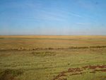
|
Akmola and Kostanay Regions, 50°26′N 69°11′E / 50.433°N 69.183°E |
Natural: (ix), (x) |
450,344 (1,112,820); buffer zone 211,148 (521,760) | 2008 | [24] |
| Silk Roads: the Routes Network of Chang'an-Tianshan Corridor | 
|
22 sites in 8 sites in 3 sites in |
Cultural: (ii)(iii)(iv)(vi) |
42,668.16 (105,435.3); buffer zone 189,963.13 (469,409.1) | 2014 | [25] |
| State Historical and Cultural Park “Ancient Merv” | 
|
Mary Region, 37°42′3″N 62°10′39″E / 37.70083°N 62.17750°E |
Cultural: (ii), (iii) |
353 (870); buffer zone 883 (2,180) | 1999 | [26] |
| Sulaiman-Too Sacred Mountain | 
|
Osh, 40°31′52″N 72°46′58″E / 40.53111°N 72.78278°E |
Cultural: (iii), (vi) |
112 (280); buffer zone 4,788 (11,830) | 2009 | [27] |
| Tajik National Park (Mountains of the Pamirs) | 
|
38°45′54″N 72°18′19″E / 38.76500°N 72.30528°E |
Natural: (vii), (viii) |
2,611,674 (6,453,590) | 2013 | [28] |
| Uvs Nuur Basin | 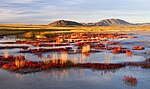
|
Uvs, Zavkhan and Khövsgöl Provinces Mongun-Tayginsky, Ovyursky, Tes-Khemsky and Erzinsky Districts, Tuva Republic, 50°16′30″N 92°43′1″E / 50.27500°N 92.71694°E |
Natural: (ix), (x) |
898,064 (2,219,160); buffer zone 170,790 (422,000) | 2003 | [29] |
| Volcanoes of Kamchatka | 
|
Kamchatka Krai, 56°20′N 158°30′E / 56.333°N 158.500°E |
Natural: (vii), (viii), (ix), (x) |
3,830,200 (9,465,000) | 1996[nb 1] | [30][31] |
Tentative List edit


Notes edit
- ^ Extended in 2001 to include Kluchevskoy Nature Park.
References edit
- Notes
- ^ "Number of World Heritage Properties by region". UNESCO. Retrieved 10 September 2011.
- ^ "Composition of macro geographical (continental) regions, geographical sub-regions, and selected economic and other groupings". Geographical region and composition of each region. United Nations Statistics Division. 2010. Retrieved 20 October 2011.
- ^ a b "World Heritage List". UNESCO. Retrieved 28 May 2010.
- ^ "Number of World Heritage properties inscribed each Year". UNESCO. Retrieved 8 September 2011.
- ^ a b "The Criteria for Selection". UNESCO. Retrieved 10 September 2011.
- ^ "World Heritage List Nominations". UNESCO. Retrieved 28 May 2010.
- ^ "World Heritage in Danger". UNESCO. Retrieved 28 May 2010.
- ^ "Central Sikhote-Alin". UNESCO. Retrieved 20 October 2011.
- ^ "Golden Mountains of Altai". UNESCO. Retrieved 20 October 2011.
- ^ "Historic Centre of Bukhara". UNESCO. Retrieved 20 October 2011.
- ^ "Historic Centre of Shakhrisyabz". UNESCO. Retrieved 20 October 2011.
- ^ "Itchan Kala". UNESCO. Retrieved 20 October 2011.
- ^ "Kunya-Urgench". UNESCO. Retrieved 20 October 2011.
- ^ "Lake Baikal". UNESCO. Retrieved 20 October 2011.
- ^ Centre, UNESCO World Heritage. "Landscapes of Dauria". whc.unesco.org. Retrieved 2018-07-03.
- ^ "Lena Pillars Nature Park". UNESCO. Retrieved 4 August 2013.
- ^ "Mausoleum of Khoja Ahmed Yasawi". UNESCO. Retrieved 20 October 2011.
- ^ "Natural System of Wrangel Island Reserve". UNESCO. Retrieved 20 October 2011.
- ^ "Parthian Fortresses of Nisa". UNESCO. Retrieved 20 October 2011.
- ^ "Petroglyphs within the Archaeological Landscape of Tamgaly". UNESCO. Retrieved 20 October 2011.
- ^ "Proto-urban site of Sarazm". UNESCO. Retrieved 20 October 2011.
- ^ "Putorana Plateau". UNESCO. Retrieved 20 October 2011.
- ^ "Samarkand – Crossroads of Cultures". UNESCO. Retrieved 20 October 2011.
- ^ "Saryarka — Steppe and Lakes of Northern Kazakhstan". UNESCO. Retrieved 20 October 2011.
- ^ "Silk Road". UNESCO. Retrieved 22 June 2014.
- ^ "State Historical and Cultural Park "Ancient Merv"". UNESCO. Retrieved 20 October 2011.
- ^ "Sulaiman-Too Sacred Mountain". UNESCO. Retrieved 20 October 2011.
- ^ "Tajik National Park (Mountains of the Pamirs)". UNESCO. Retrieved 4 August 2013.
- ^ "Uvs Nuur Basin". UNESCO. Retrieved 20 October 2011.
- ^ "Volcanoes of Kamchatka". UNESCO. Retrieved 20 October 2011.
- ^ "Decision – 25COM X.B – Volcanoes of Kamchatka [Extension to include Kluchevskoy Nature Park] (Russian Federation)". UNESCO. Retrieved 20 October 2011.
- ^ Centre, UNESCO World Heritage. "Cultural Landscape of Ulytau". UNESCO World Heritage Centre. Retrieved 2022-07-22.
- ^ Centre, UNESCO World Heritage. "Northern Tyan-Shan (Ile-Alatau State National Park)". UNESCO World Heritage Centre. Retrieved 2022-07-22.
- ^ "State National Natural Park "Altyn-Emel" - UNESCO World Heritage Centre". 2020-06-22. Archived from the original on 22 June 2020. Retrieved 2022-07-22.
- ^ Centre, UNESCO World Heritage. "Saimaly-Tash Petroglyphs". UNESCO World Heritage Centre. Retrieved 2022-07-22.
- ^ Centre, UNESCO World Heritage. "Khulbuk – the capital of ancient Khuttal". UNESCO World Heritage Centre. Retrieved 2022-07-22.
- ^ Centre, UNESCO World Heritage. "Fann mountains". UNESCO World Heritage Centre. Retrieved 2022-07-22.
- ^ Centre, UNESCO World Heritage. "Mausoleum of "Amir Khamza Khasti Podshoh"". UNESCO World Heritage Centre. Retrieved 2022-07-22.
- ^ Centre, UNESCO World Heritage. "Mausoleum of "Khoja Mashkhad"". UNESCO World Heritage Centre. Retrieved 2022-07-22.
- ^ Centre, UNESCO World Heritage. "The Site of Ancient Town of Takhti-Sangin". UNESCO World Heritage Centre. Retrieved 2022-07-22.
- ^ Centre, UNESCO World Heritage. "Bahoutdin Architectural Complex". UNESCO World Heritage Centre. Retrieved 2022-07-22.
- ^ Centre, UNESCO World Heritage. "Historic Center of Qoqon". UNESCO World Heritage Centre. Retrieved 2022-07-22.
- ^ Centre, UNESCO World Heritage. "Andijon". UNESCO World Heritage Centre. Retrieved 2022-07-22.
- ^ Centre, UNESCO World Heritage. "Ancient Termiz". UNESCO World Heritage Centre. Retrieved 2022-07-22.
- ^ Centre, UNESCO World Heritage. "Centre historique d'Irkoutsk". UNESCO World Heritage Centre. Retrieved 2022-07-22.
- ^ Centre, UNESCO World Heritage. "Historic Center of the Yenisseisk". UNESCO World Heritage Centre. Retrieved 2022-07-22.
- ^ Centre, UNESCO World Heritage. "Valley of the Kings of Tuva". UNESCO World Heritage Centre. Retrieved 2022-07-22.
- ^ Centre, UNESCO World Heritage. "National Park Kytalyk". UNESCO World Heritage Centre. Retrieved 2022-07-22.
- ^ Centre, UNESCO World Heritage. "Krasnoyarsk Stolby". UNESCO World Heritage Centre. Retrieved 2022-07-22.
- ^ Centre, UNESCO World Heritage. "Magadansky State Nature Reserve". UNESCO World Heritage Centre. Retrieved 2022-07-22.