
KNOWPIA
WELCOME TO KNOWPIA

List of highest U.S. county high points 
Summary
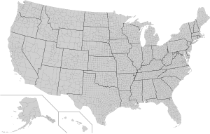
The following table lists the 60 highest United States county or county-equivalent[a] high points.[b] The highest U.S. county high point is the summit of Denali in the Denali Borough of Alaska, the highest summit of the United States and all of North America. Of these 60 highest county high points, 32 are located in Colorado, seven in California, six each in Alaska and Wyoming, three in New Mexico, two each in Utah and Nevada, and one each in Washington and Hawaiʻi. Use the OpenStreetMap link below to view the location of these county high points.
Highest U.S. county high points edit
| Rank[c] | County.[a][2] | State | High point[3][b] | Highest elevation[4][5][2][3][d] | Low point[2][e] | Lowest elevation[4][2][d] | Mean elevation[f] | Elevation range[g] | High point coordinates[h] |
|---|---|---|---|---|---|---|---|---|---|
| 1 | Denali Borough[i] | Denali[8][j] | 20,310 feet 6,190.5 m |
Nenana River | 385 feet 117 m |
10,348 feet 3,154 m |
19,925 feet 6,073 m |
63°04′08″N 151°00′23″W / 63.0690°N 151.0063°W | |
| 2 | Yakutat Borough | Mount Saint Elias[9][k] | 18,008 feet 5,489 m |
Gulf of Alaska | sea level | 9,004 feet 2,744 m |
18,008 feet 5,489 m |
60°17′34″N 140°55′51″W / 60.2927°N 140.9307°W | |
| 3 | Copper River Census Area | Mount Bona[10] | 16,550 feet 5,044 m |
Copper River | 328 feet 100 m |
8,439 feet 2,572 m |
16,222 feet 4,944 m |
61°23′08″N 141°44′58″W / 61.3856°N 141.7495°W | |
| 4 | Hoonah–Angoon Census Area | Mount Fairweather[11][l] | 15,325 feet 4,671 m |
Gulf of Alaska | sea level | 7,662 feet 2,335 m |
15,325 feet 4,671 m |
58°54′23″N 137°31′35″W / 58.9064°N 137.5265°W | |
| 5 | Matanuska-Susitna Borough | Mount Hunter[12] | 14,573 feet 4,442 m |
Cook Inlet | sea level | 7,286 feet 2,221 m |
14,573 feet 4,442 m |
62°57′01″N 151°05′29″W / 62.9504°N 151.0915°W | |
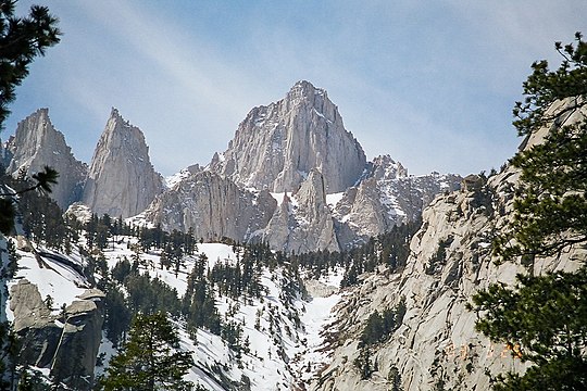
| 6 | Tulare County | Mount Whitney[13][14][m] | 14,504.6 feet 4,421.0 m |
Kings River | 285 feet 87 m |
7,395 feet 2,254 m |
14,220 feet 4,334 m |
36°34′43″N 118°17′33″W / 36.5786°N 118.2924°W | |
| Inyo County[n] | Badwater Basin[o] | −282 feet −86 m |
7,111 feet 2,167 m |
14,787 feet 4,507 m | |||||
| 8 | Lake County[15][16][p] | Mount Elbert[17][18][q] | 14,439.6 feet 4,401.2 m |
Arkansas River[r] | 8,965 feet 2,733 m |
11,702 feet 3,567 m |
5,475 feet 1,669 m |
39°07′04″N 106°26′43″W / 39.1178°N 106.4453°W | |
| 9 | Chaffee County | Mount Harvard[19][20][s] | 14,421.3 feet 4,395.6 m |
Arkansas River | 6,895 feet 2,102 m |
10,658 feet 3,249 m |
7,526 feet 2,294 m |
38°55′28″N 106°19′15″W / 38.9245°N 106.3208°W | |
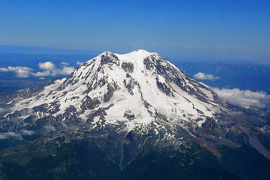
| 10 | Pierce County | Mount Rainier[21][t] | 14,417 feet 4,394 m |
Puget Sound | sea level | 7,208 feet 2,197 m |
14,417 feet 4,394 m |
46°51′10″N 121°45′37″W / 46.8529°N 121.7604°W | |
| 11 | Alamosa County | Blanca Peak[22][u] | 14,351 feet 4,374 m |
Rio Grande | 7,506 feet 2,288 m |
10,928 feet 3,331 m |
6,845 feet 2,086 m |
37°34′39″N 105°29′08″W / 37.5775°N 105.4856°W | |
| Costilla County | Rio Grande | 7,380 feet 2,249 m |
10,866 feet 3,312 m |
6,971 feet 2,125 m | |||||
| 13 | Huerfano County | Blanca Peak Tripoint[23][v] | 14,326 feet 4,367 m |
Cucharas River | 5,232 feet 1,595 m |
9,779 feet 2,981 m |
9,094 feet 2,772 m |
37°34′40″N 105°29′07″W / 37.5778°N 105.4854°W | |
| 14 | Hinsdale County | Uncompahgre Peak[24][w] | 14,315 feet 4,363 m |
Lake Fork Gunnison River | 8,285 feet 2,525 m |
11,300 feet 3,444 m |
6,030 feet 1,838 m |
38°04′18″N 107°27′44″W / 38.0717°N 107.4622°W | |
| 15 | Saguache County | Crestone Peak[25] | 14,300 feet 4,359 m |
San Luis Creek | 7,530 feet 2,295 m |
10,915 feet 3,327 m |
6,770 feet 2,063 m |
37°58′01″N 105°35′08″W / 37.9669°N 105.5855°W | |
| 16 | Park County | Mount Lincoln[26][27][x] | 14,293 feet 4,356.5 m |
South Platte River | 7,118 feet 2,170 m |
10,706 feet 3,263 m |
7,175 feet 2,187 m |
39°21′05″N 106°06′42″W / 39.3515°N 106.1116°W | |
| 17 | Pitkin County | Castle Peak[28][29][y] | 14,278.9 feet 4,352.2 m |
Crystal River | 6,260 feet 1,908 m |
10,269 feet 3,130 m |
8,019 feet 2,444 m |
39°00′35″N 106°51′41″W / 39.0096°N 106.8613°W | |
| Gunnison County | North Fork Gunnison River | 5,910 feet 1,801 m |
10,094 feet 3,077 m |
8,369 feet 2,551 m | |||||
| 19 | Summit County | Grays Peak[30][31][z] | 14,276 feet 4,351 m |
Blue River | 7,595 feet 2,315 m |
10,936 feet 3,333 m |
6,681 feet 2,036 m |
39°38′01″N 105°49′03″W / 39.6337°N 105.8176°W | |
| Clear Creek County | Clear Creek | 6,940 feet 2,115 m |
10,608 feet 3,233 m |
7,336 feet 2,236 m | |||||
| 21 | Custer County | Crestone East Peak[32][aa] | 14,266 feet 4,348 m |
Hardscrabble Creek | 5,885 feet 1,794 m |
10,076 feet 3,071 m |
8,381 feet 2,555 m |
37°58′02″N 105°35′02″W / 37.9673°N 105.5840°W | |
| 22 | Boulder County | Longs Peak[33][34][ab] | 14,260 feet 4,346 m |
Saint Vrain Creek | 4,895 feet 1,492 m |
9,578 feet 2,919 m |
9,365 feet 2,854 m |
40°15′18″N 105°36′58″W / 40.2549°N 105.6161°W | |
| 23 | Dolores County | Mount Wilson[35][ac] | 14,252 feet 4,344 m |
Spook Canyon | 5,190 feet 1,582 m |
9,721 feet 2,963 m |
9,062 feet 2,762 m |
37°50′21″N 107°59′30″W / 37.8391°N 107.9916°W | |
| Mono County | White Mountain Peak[36][37][ad] | 14,252 feet 4,344 m |
Owens River | 4,652 feet 1,418 m |
9,452 feet 2,881 m |
9,600 feet 2,926 m |
37°38′03″N 118°15′21″W / 37.6341°N 118.2557°W | ||
| 25 | Fresno County | North Palisade[38][39][ae] | 14,248 feet 4,343 m |
San Joaquin River | 118 feet 36 m |
7,183 feet 2,189 m |
14,130 feet 4,307 m |
37°05′39″N 118°30′52″W / 37.0942°N 118.5145°W | |
| 26 | Siskiyou County | Mount Shasta[40][41][af] | 14,168 feet 4,318 m |
Klamath River | 475 feet 145 m |
7,322 feet 2,232 m |
13,693 feet 4,174 m |
41°24′32″N 122°11′42″W / 41.4090°N 122.1949°W | |
| 27 | Ouray County | Mount Sneffels[42][43][ag] | 14,158.1 feet 4,315.4 m |
Uncompahgre River | 6,340 feet 1,932 m |
10,249 feet 3,124 m |
7,818 feet 2,383 m |
38°00′14″N 107°47′32″W / 38.0038°N 107.7923°W | |
| 28 | El Paso County | Pikes Peak[44][45][ah] | 14,115.2 feet 4,302.31 m |
Chico Creek | 5,045 feet 1,538 m |
9,580 feet 2,920 m |
9,070 feet 2,765 m |
38°50′26″N 105°02′41″W / 38.8405°N 105.0446°W | |
| 29 | La Plata County | Windom Peak[46][ai] | 14,093 feet 4,296 m |
Animas River | 5,930 feet 1,807 m |
10,012 feet 3,052 m |
8,163 feet 2,488 m |
37°37′16″N 107°35′31″W / 37.6212°N 107.5919°W | |
| 30 | San Miguel County | Wilson Peak[47][aj] | 14,023 feet 4,274 m |
Dolores River | 5,310 feet 1,618 m |
9,666 feet 2,946 m |
8,713 feet 2,656 m |
37°51′37″N 107°59′05″W / 37.8603°N 107.9847°W | |
| 31 | Eagle County | Mount of the Holy Cross[48][49][ak] | 14,011 feet 4,271 m |
Colorado River | 6,125 feet 1,867 m |
10,068 feet 3,069 m |
7,886 feet 2,404 m |
39°28′00″N 106°28′54″W / 39.4667°N 106.4817°W | |
| 32 | Mineral County | Phoenix Peak[50] | 13,902 feet 4,237 m |
Rio Grande | 8,330 feet 2,539 m |
11,116 feet 3,388 m |
5,572 feet 1,698 m |
37°56′11″N 106°51′59″W / 37.9363°N 106.8664°W | |
| 33 | San Juan County | Vermilion Peak[51] | 13,900 feet 4,237 m |
Animas River | 8,270 feet 2,521 m |
11,085 feet 3,379 m |
5,630 feet 1,716 m |
37°47′57″N 107°49′43″W / 37.7993°N 107.8285°W | |
| 34 | Southeast Fairbanks Census Area | Mount Hayes[52][al] | 13,832 feet 4,216 m |
Tanana River | 1,040 feet 317 m |
7,436 feet 2,266 m |
12,792 feet 3,899 m |
63°37′13″N 146°43′04″W / 63.6203°N 146.7178°W | |
| 35 | Sublette County | Gannett Peak[53][54][am] | 13,809.4 feet 4,209.1 m |
Green River | 6,570 feet 2,003 m |
10,190 feet 3,106 m |
7,239 feet 2,206 m |
43°11′04″N 109°39′15″W / 43.1844°N 109.6543°W | |
| Fremont County | Wind River | 4,558 feet 1,389 m |
9,184 feet 2,799 m |
9,251 feet 2,820 m | |||||
| 37 | Hawaiʻi County | Mauna Kea[55][56][an] | 13,796 feet 4,205 m |
Pacific Ocean | sea level | 6,898 feet 2,103 m |
13,796 feet 4,205 m |
19°49′15″N 155°28′05″W / 19.8207°N 155.4680°W | |
| 38 | Teton County | Grand Teton[57][58][ao] | 13,775.3 feet 4,198.7 m |
Snake River | 5,804 feet 1,769 m |
9,790 feet 2,984 m |
7,971 feet 2,430 m |
43°44′28″N 110°48′09″W / 43.7412°N 110.8025°W | |
| 39 | Las Animas County | West Spanish Peak[59][ap] | 13,631 feet 4,155 m |
Purgatoire River | 4,324 feet 1,318 m |
8,978 feet 2,736 m |
9,307 feet 2,837 m |
37°22′32″N 104°59′36″W / 37.3756°N 104.9934°W | |
| 40 | Larimer County | Hagues Peak[60][61][aq] | 13,566 feet 4,135 m |
Cache la Poudre River | 4,785 feet 1,458 m |
9,176 feet 2,797 m |
8,781 feet 2,676 m |
40°29′04″N 105°38′47″W / 40.4845°N 105.6464°W | |
| 41 | Grand County | Pettingell Peak[62] | 13,559 feet 4,133 m |
Colorado River | 6,835 feet 2,083 m |
10,197 feet 3,108 m |
6,724 feet 2,049 m |
39°43′43″N 105°54′18″W / 39.7286°N 105.9049°W | |
| 42 | Duchesne County | Kings Peak[63][ar] | 13,534 feet 4,125 m |
Ninemile Creek | 4,850 feet 1,478 m |
9,192 feet 2,802 m |
8,684 feet 2,647 m |
40°46′35″N 110°22′22″W / 40.7763°N 110.3729°W | |
| 43 | Summit County | Gilbert Peak[64][as] | 13,448 feet 4,099 m |
Weber River | 5,255 feet 1,602 m |
9,352 feet 2,850 m |
8,193 feet 2,497 m |
40°49′25″N 110°20′25″W / 40.8235°N 110.3403°W | |
| 44 | Archuleta County | Summit Peak[65][66][at] | 13,307.7 feet 4,056.2 m |
Navajo Reservoir[au] | 6,027 feet 1,837 m |
9,669 feet 2,947 m |
7,278 feet 2,218 m |
37°21′02″N 106°41′49″W / 37.3506°N 106.6969°W | |
| 45 | Gilpin County | James Peak[67] | 13,300 feet 4,054 m |
Clear Creek | 6,940 feet 2,115 m |
10,120 feet 3,085 m |
6,360 feet 1,939 m |
39°51′07″N 105°41′25″W / 39.8520°N 105.6903°W | |
| 46 | Montezuma County | Hesperus Mountain[68][av] | 13,237 feet 4,035 m |
San Juan River | 4,602 feet 1,403 m |
8,920 feet 2,719 m |
8,635 feet 2,632 m |
37°26′42″N 108°05′20″W / 37.4451°N 108.0890°W | |
| 47 | Rio Grande County | Bennett Peak[69] | 13,209 feet 4,026 m |
Rock Creek | 7,595 feet 2,315 m |
10,402 feet 3,171 m |
5,614 feet 1,711 m |
37°29′00″N 106°26′03″W / 37.4833°N 106.4343°W | |
| 48 | Conejos County | Conejos Peak[70][71] | 13,178 feet 4,017 m |
Rio Grande | 7,380 feet 2,249 m |
10,279 feet 3,133 m |
5,798 feet 1,767 m |
37°17′20″N 106°34′15″W / 37.2888°N 106.5708°W | |
| 49 | Johnson County | Cloud Peak[72][73][aw] | 13,167 feet 4,013.3 m |
Powder River | 3,695 feet 1,126 m |
8,431 feet 2,570 m |
9,472 feet 2,887 m |
44°22′55″N 107°10′26″W / 44.3820°N 107.1740°W | |
| Big Horn County | Bighorn Lake[ax] | 3,290 feet 1,003 m |
8,228 feet 2,508 m |
9,877 feet 3,011 m | |||||
| 51 | Taos County | Wheeler Peak[74][75][ay] | 13,166 feet 4,013 m |
Rio Grande | 5,882 feet 1,793 m |
9,524 feet 2,903 m |
7,284 feet 2,220 m |
36°33′24″N 105°25′01″W / 36.5568°N 105.4169°W | |
| 52 | Park County | Francs Peak[76][77][az] | 13,158 feet 4,011 m |
Yellowstone River | 5,550 feet 1,692 m |
9,354 feet 2,851 m |
7,608 feet 2,319 m |
43°57′41″N 109°20′22″W / 43.9613°N 109.3394°W | |
| 53 | Esmeralda County | Boundary Peak[78][ba] | 13,149.6 feet 4,008.0 m |
California border | 3,715 feet 1,132 m |
9,087 feet 2,770 m |
8,125 feet 2,476 m |
37°50′46″N 118°21′05″W / 37.8461°N 118.3514°W | |
| 54 | Madera County | Mount Ritter[79][bb] | 13,149 feet 4,008 m |
San Joaquin River | 118 feet 36 m |
6,634 feet 2,022 m |
13,031 feet 3,972 m |
37°41′21″N 119°11′59″W / 37.6891°N 119.1996°W | |
| 55 | Tuolumne County | Mount Lyell[80][81] | 13,119.8 feet 3,998.9 m |
Tuolumne River | 300 feet 91 m |
6,710 feet 2,045 m |
12,820 feet 3,908 m |
37°44′22″N 119°16′18″W / 37.7394°N 119.2716°W | |
| 56 | Fremont County | Bushnell Peak[82][83] | 13,111 feet 3,996 m |
Arkansas River | 4,945 feet 1,507 m |
9,028 feet 2,752 m |
8,166 feet 2,489 m |
38°20′28″N 105°53′21″W / 38.3412°N 105.8893°W | |
| 57 | Rio Arriba County | Truchas Peak[84][85][bc] | 13,107 feet 3,995 m |
Rio Grande | 5,535 feet 1,687 m |
9,321 feet 2,841 m |
7,572 feet 2,308 m |
35°57′45″N 105°38′42″W / 35.9625°N 105.6451°W | |
| Mora County | Canadian River | 4,668 feet 1,423 m |
8,888 feet 2,709 m |
8,439 feet 2,572 m | |||||
| 59 | Teller County | Devils Playground[86][bd] | 13,075 feet 3,985 m |
Fourmile Creek | 6,710 feet 2,045 m |
9,892 feet 3,015 m |
6,365 feet 1,940 m |
38°51′51″N 105°04′14″W / 38.8642°N 105.0705°W | |
| 60 | White Pine County | Wheeler Peak[87][88][be] | 13,065.3 feet 3,982.3 m |
Utah border | 5,080 feet 1,548 m |
9,073 feet 2,765 m |
7,985 feet 2,434 m |
38°59′09″N 114°18′50″W / 38.9858°N 114.3139°W |
Gallery edit
-
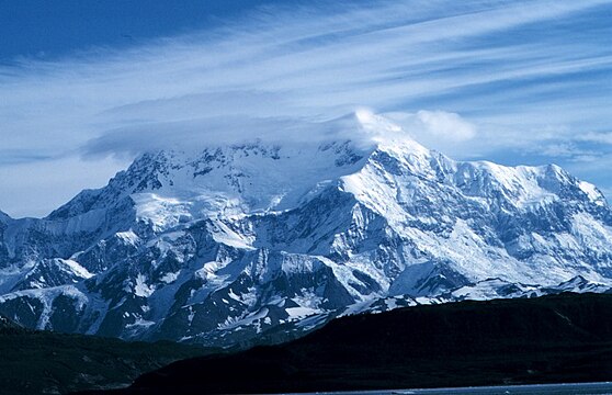
 1. Denali in Denali Borough, Alaska
 -
-
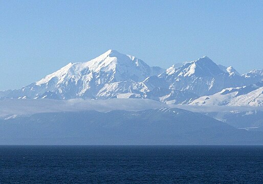
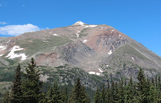
 3. Mount Bona in the Copper River Census Area, Alaska
 -
-
-
-

-
-
-

-
-

-
-
-

-


See also edit
Notes edit
- ^ a b c Forty-eight U.S. states have counties, Louisiana has parishes, and Alaska has boroughs and census areas in the Unorganized Borough. The entire District of Columbia is considered a county-equivalent, as are the 38 independent cities of Virginia, and the independent cities of Baltimore, Maryland, St. Louis, Missouri, and Carson City, Nevada.[1]
- ^ a b c The high point of an area is the point of maximum topographic elevation. The high point may, or may not, be a summit.
- ^ Rank among United States counties and county-equivalents[1] by high point elevation.[b]
- ^ a b Topographic elevations are adjusted to the North American Vertical Datum of 1988 (NAVD 88).[6]
- ^ The low point of an area is the point of minimum topographic elevation. The low point is often a gulch, stream, river, reservoir, lake, ocean, or endorheic basin.
- ^ a b The "mean of extremes" elevation is the arithmetic mean of the highest and lowest elevations.
- ^ a b The elevation range is the arithmetic difference between the highest and lowest elevations.
- ^ Geodetic coordinates are adjusted to the World Geodetic System of 1984 (WGS 84).[7]
- ^ The Denali Borough, Alaska has the greatest elevation range[g] of any U.S. county or county-equivalent[a] at 19,925 feet (6,073 m).
- ^ The summit of Denali is the highest point in the United States and all of North America with an elevation of 20,310 feet (6,190.5 m). Denali is both the third most topographically prominent summit and the third most topographically isolated summit on Earth after Mount Everest and Aconcagua. Denali is the highest point in the Arctic Ocean Basin.
- ^ Mount Saint Elias is the highest summit of the Saint Elias Mountains and the second highest major summit of both Canada and the United States.
- ^ Mount Fairweather is the highest summit of the Fairweather Range.
- ^ Mount Whitney is the highest summit of the Sierra Nevada and the State of California. Mount Whitney is the highest point of both the San Joaquin Basin and the Great Basin.
- ^ Inyo County, California, has the sixth highest U.S. county high point and lowest point of all of North America for a county elevation range of 14,787 feet (4,507 m), the greatest south of Alaska.
- ^ The Badwater Basin, an endorheic basin in Death Valley, is the lowest point in the United States and all of North America with an elevation of −282 feet (−86 m).
- ^ Lake County, Colorado is the highest county in the United States by mean elevation[f] at 11,702 feet (3,567 m).
- ^ Mount Elbert is the highest summit of the Rocky Mountains of the United States and Canada. Mount Elbert is the highest summit of the State of Colorado and the highest point in the Mississippi River Basin.
- ^ The point where the Arkansas River flows out of Lake County and into Chaffee County, Colorado, is the highest county low point in the United States at 8,965 feet (2,733 m) elevation.
- ^ Mount Harvard is the highest summit of the Collegiate Peaks and the easternmost point of its elevation in the United States.
- ^ Mount Rainier is the highest summit of the State of Washington and the highest summit of the Cascade Range of the United States and Canada.
- ^ Blanca Peak is the highest summit of the Sangre de Cristo Range and the easternmost point of its elevation in the United States. Blanca Peak is the highest point in the Rio Grande Basin of the United States and México.
- ^ The Blanca Peak Tripoint is located 140 feet (43 m) north-northeast and 25 feet (7.6 m) below the summit of Blanca Peak. The Tripoint is the junction of Alamosa, Costilla, and Huerfano counties, Colorado. This point gave surveyors a better point to set the intersection of the three counties than the summit itself.
- ^ Uncompahgre Peak is the highest summit of the San Juan Mountains. Uncompahgre Peak is the highest point in the Colorado River Basin of the United States and México.
- ^ Mount Lincoln is the highest summit of the Mosquito Range.
- ^ Castle Peak is the highest summit of the Elk Mountains.
- ^ Grays Peak is the highest summit of the Front Range and the highest point on the Continental Divide in North America.
- ^ Crestone East Peak is located 432 feet (132 m) east-northeast and 34 feet (10.4 m) below the summit of Crestone Peak.
- ^ Longs Peak is the highest summit of the northern Front Range.
- ^ Mount Wilson is the highest summit of the San Miguel Mountains.
- ^ White Mountain Peak is the highest summit of the White Mountains.
- ^ North Palisade is the highest summit of the central Sierra Nevada.
- ^ Mount Shasta is the highest summit of the Cascade Range in California.
- ^ Mount Sneffels is the highest summit of the Sneffels Range.
- ^ Pikes Peak is the highest summit of the southern Front Range and the easternmost point of its elevation in the United States.
- ^ Windom Peak is the highest summit of the Needle Mountains.
- ^ Wilson Peak is located 1.51 miles (2.43 km) north-northeast and 229 feet (70 m) lower than the summit of Mount Wilson.
- ^ Mount of the Holy Cross is the highest summit of the northern Sawatch Range.
- ^ Mount Hayes is the highest summit of the Hayes Range.
- ^ Gannett Peak is the highest summit of the Wind River Range, the Central Rocky Mountains, and the State of Wyoming. Gannett Peak is the highest point in the Green River Basin.
- ^ Mauna Kea is the highest summit of the Island of Hawaiʻi, the State of Hawaiʻi, and the entire North Pacific Ocean. Mauna Kea is the tallest mountain on Earth if measured from its base at −19,684 feet (−6,000 m) below the surface of the Pacific Ocean to its summit at 13,796 feet (4,205 m) for a total of 33,480 feet (10,205 m).
- ^ Grand Teton is the highest summit of the Teton Range. Grand Teton is the highest point in the Columbia River drainage basin of Canada and the United States.
- ^ West Spanish Peak is the higher summit of the two Spanish Peaks. Both Spanish Peaks are the easternmost points of their respective elevation in the United States. The Spanish Peaks were important historic landmarks along the Santa Fe Trail.
- ^ Hagues Peak is the highest summit of the Mummy Range.
- ^ Kings Peak is the highest summit of the Uinta Range, the Western Rocky Mountains, and the State of Utah.
- ^ Gilbert Peak is located 3.7 miles (6.0 km) north-northeast and 86 feet (26 m) lower than the summit of Kings Peak.
- ^ Summit Peak is the highest summit of the southern San Juan Mountains.
- ^ The elevation of Navajo Reservoir varies seasonally.
- ^ Hesperus Mountain is the highest summit of the La Plata Mountains.
- ^ Cloud Peak is the highest summit of the Bighorn Mountains.
- ^ The elevation of Bighorn Lake varies seasonally.
- ^ Wheeler Peak is the highest summit of the Taos Mountains and the State of New Mexico.
- ^ Francs Peak is the highest summit of the Absaroka Range.
- ^ Boundary Peak is the highest summit of the State of Nevada.
- ^ Mount Ritter is the highest summit of the Ritter Range.
- ^ Truchas Peak is the highest summit of the Santa Fe Mountains.
- ^ The Devils Playground is located 2.15 miles (3.46 km) northwest and 1,040 feet (317 m) below the summit of Pikes Peak. The Devils Playground is named for the way lightning sometimes dances around the prominence during lightning storms.
- ^ Wheeler Peak is the highest summit of the Snake Range.
References edit
- ^ a b "County and equivalent entity". United States Census Bureau, United States Department of Commerce. Retrieved August 17, 2022.
- ^ a b c d "National Map Search". United States Geological Survey, United States Department of Commerce. Retrieved August 17, 2022.
- ^ a b "Peak List". Peakbagger.com. Retrieved August 17, 2022.
- ^ a b "Finding Survey Marks and Datasheets". National Geodetic Survey, National Oceanic and Atmospheric Administration, United States Department of Commerce. Retrieved August 17, 2022.
- ^ "Elevation Point Query Service". United States Geological Survey, United States Department of Commerce. Retrieved August 17, 2022.
- ^ "North American Vertical Datum of 1988 (NAVD 88)". National Geodetic Survey, National Oceanic and Atmospheric Administration, United States Department of Commerce. July 12, 2018. Retrieved August 17, 2022.
- ^ "World Geodetic System 1984 (WGS 84)". National Geospatial-Intelligence Agency, United States Department of Defense. March 1, 2022. Retrieved August 17, 2022.
- ^ "Denali, Alaska". Peakbagger.com. Retrieved August 16, 2022.
- ^ "Mount Saint Elias, Alaska/Yukon". Peakbagger.com. Retrieved August 16, 2022.
- ^ "Mount Bona, Alaska". Peakbagger.com. Retrieved August 16, 2022.
- ^ "Mount Fairweather, Alaska/British Columbia". Peakbagger.com. Retrieved August 16, 2022.
- ^ "Mount Hunter, Alaska". Peakbagger.com. Retrieved August 16, 2022.
- ^ "WHITNEY". NGS Data Sheet. National Geodetic Survey, National Oceanic and Atmospheric Administration, United States Department of Commerce. Retrieved September 7, 2022.
- ^ "Mount Whitney, California". Peakbagger.com. Retrieved August 16, 2022.
- ^ "MOUNT ELBERT". NGS Data Sheet. National Geodetic Survey, National Oceanic and Atmospheric Administration, United States Department of Commerce. Retrieved September 7, 2022.
- ^ "Mount Elbert, Colorado". Peakbagger.com. Retrieved September 7, 2022.
- ^ "MOUNT ELBERT". NGS Data Sheet. National Geodetic Survey, National Oceanic and Atmospheric Administration, United States Department of Commerce. Retrieved September 7, 2022.
- ^ "Mount Elbert, Colorado". Peakbagger.com. Retrieved September 7, 2022.
- ^ "HARVARD". NGS Data Sheet. National Geodetic Survey, National Oceanic and Atmospheric Administration, United States Department of Commerce. Retrieved September 7, 2022.
- ^ "Mount Harvard, Colorado". Peakbagger.com. Retrieved August 16, 2022.
- ^ "Mount Rainier, Washington". Peakbagger.com. Retrieved August 16, 2022.
- ^ "Blanca Peak, Colorado". Peakbagger.com. Retrieved August 16, 2022.
- ^ "Blanca Peak-Northeast Slope, Colorado". Peakbagger.com. Retrieved August 16, 2022.
- ^ "Uncompahgre Peak, Colorado". Peakbagger.com. Retrieved August 16, 2022.
- ^ "Crestone Peak, Colorado". Peakbagger.com. Retrieved August 17, 2022.
- ^ "MT LINCOLN". NGS Data Sheet. National Geodetic Survey, National Oceanic and Atmospheric Administration, United States Department of Commerce. Retrieved September 7, 2022.
- ^ "Mount Lincoln, Colorado". Peakbagger.com. Retrieved August 16, 2022.
- ^ "CASTLE PK". NGS Data Sheet. National Geodetic Survey, National Oceanic and Atmospheric Administration, United States Department of Commerce. Retrieved September 7, 2022.
- ^ "Castle Peak, Colorado". Peakbagger.com. Retrieved August 16, 2022.
- ^ "GRAYS PEAK". NGS Data Sheet. National Geodetic Survey, National Oceanic and Atmospheric Administration, United States Department of Commerce. Retrieved September 7, 2022.
- ^ "Grays Peak, Colorado". Peakbagger.com. Retrieved August 16, 2022.
- ^ "Crestone Peak-East Peak, Colorado". Peakbagger.com. Retrieved August 17, 2022.
- ^ "LONGS PEAK". NGS Data Sheet. National Geodetic Survey, National Oceanic and Atmospheric Administration, United States Department of Commerce. Retrieved September 7, 2022.
- ^ "Longs Peak, Colorado". Peakbagger.com. Retrieved August 16, 2022.
- ^ "Mount Wilson, Colorado". Peakbagger.com. Retrieved August 17, 2022.
- ^ "WHITE MOUNTAIN PEAK". NGS Data Sheet. National Geodetic Survey, National Oceanic and Atmospheric Administration, United States Department of Commerce. Retrieved September 7, 2022.
- ^ "White Mountain Peak, California". Peakbagger.com. Retrieved August 16, 2022.
- ^ "NORTH PALISADE". NGS Data Sheet. National Geodetic Survey, National Oceanic and Atmospheric Administration, United States Department of Commerce. Retrieved September 7, 2022.
- ^ "North Palisade, California". Peakbagger.com. Retrieved August 16, 2022.
- ^ "MT SHASTA". NGS Data Sheet. National Geodetic Survey, National Oceanic and Atmospheric Administration, United States Department of Commerce. Retrieved September 7, 2022.
- ^ "Mount Shasta, California". Peakbagger.com. Retrieved August 16, 2022.
- ^ "SNEFFLES". NGS Data Sheet. National Geodetic Survey, National Oceanic and Atmospheric Administration, United States Department of Commerce. Retrieved September 7, 2022.
- ^ "Mount Sneffels, Colorado". Peakbagger.com. Retrieved August 16, 2022.
- ^ "PIKES PEAK". NGS Data Sheet. National Geodetic Survey, National Oceanic and Atmospheric Administration, United States Department of Commerce. Retrieved September 7, 2022.
- ^ "Pikes Peak, Colorado". Peakbagger.com. Retrieved August 17, 2022.
- ^ "Windom Peak, Colorado". Peakbagger.com. Retrieved August 16, 2022.
- ^ "Wilson Peak, Colorado". Peakbagger.com. Retrieved August 17, 2022.
- ^ "MT HOLY CROSS ET". NGS Data Sheet. National Geodetic Survey, National Oceanic and Atmospheric Administration, United States Department of Commerce. Retrieved September 7, 2022.
- ^ "Mount of the Holy Cross, Colorado". Peakbagger.com. Retrieved August 16, 2022.
- ^ "Phoenix Peak, Colorado". Peakbagger.com. Retrieved August 16, 2022.
- ^ "Vermilion Peak, Colorado". Peakbagger.com. Retrieved August 16, 2022.
- ^ "Mount Hayes, Alaska". Peakbagger.com. Retrieved August 16, 2022.
- ^ "GANNETT PEAK CAIRN". NGS Data Sheet. National Geodetic Survey, National Oceanic and Atmospheric Administration, United States Department of Commerce. Retrieved September 7, 2022.
- ^ "Gannett Peak, Wyoming". Peakbagger.com. Retrieved September 7, 2022.
- ^ "SUMMIT". NGS Data Sheet. National Geodetic Survey, National Oceanic and Atmospheric Administration, United States Department of Commerce. Retrieved September 7, 2022.
- ^ "Mauna Kea, Hawaii". Peakbagger.com. Retrieved August 16, 2022.
- ^ "GRAND TETON". NGS Data Sheet. National Geodetic Survey, National Oceanic and Atmospheric Administration, United States Department of Commerce. Retrieved September 7, 2022.
- ^ "Grand Teton, Wyoming". Peakbagger.com. Retrieved August 16, 2022.
- ^ "West Spanish Peak, Colorado". Peakbagger.com. Retrieved August 16, 2022.
- ^ "HAGUE RM". NGS Data Sheet. National Geodetic Survey, National Oceanic and Atmospheric Administration, United States Department of Commerce. Retrieved September 7, 2022.
- ^ "Hagues Peak, Colorado". Peakbagger.com. Retrieved August 16, 2022.
- ^ "Pettingell Peak, Colorado". Peakbagger.com. Retrieved August 16, 2022.
- ^ "Kings Peak, Utah". Peakbagger.com. Retrieved August 17, 2022.
- ^ "Gilbert Peak, Utah". Peakbagger.com. Retrieved August 17, 2022.
- ^ "SUMMIT". NGS Data Sheet. National Geodetic Survey, National Oceanic and Atmospheric Administration, United States Department of Commerce. Retrieved September 7, 2022.
- ^ "Summit Peak, Colorado". Peakbagger.com. Retrieved August 16, 2022.
- ^ "James Peak, Colorado". Peakbagger.com. Retrieved August 16, 2022.
- ^ "Hesperus Mountain, Colorado". Peakbagger.com. Retrieved August 16, 2022.
- ^ "Bennett Peak, Colorado". Peakbagger.com. Retrieved August 16, 2022.
- ^ "CONEJOS". NGS Data Sheet. National Geodetic Survey, National Oceanic and Atmospheric Administration, United States Department of Commerce. Retrieved September 7, 2022.
- ^ "Conejos Peak, Colorado". Peakbagger.com. Retrieved August 16, 2022.
- ^ "CLOUD PEAK". NGS Data Sheet. National Geodetic Survey, National Oceanic and Atmospheric Administration, United States Department of Commerce. Retrieved September 7, 2022.
- ^ "Cloud Peak, Wyoming". Peakbagger.com. Retrieved August 16, 2022.
- ^ "WHEELER". NGS Data Sheet. National Geodetic Survey, National Oceanic and Atmospheric Administration, United States Department of Commerce. Retrieved September 7, 2022.
- ^ "Wheeler Peak, New Mexico". Peakbagger.com. Retrieved August 16, 2022.
- ^ "FRANCS PK 2". NGS Data Sheet. National Geodetic Survey, National Oceanic and Atmospheric Administration, United States Department of Commerce. Retrieved September 7, 2022.
- ^ "Francs Peak, Wyoming". Peakbagger.com. Retrieved August 16, 2022.
- ^ "Boundary Peak, Nevada". Peakbagger.com. Retrieved August 16, 2022.
- ^ "Mount Ritter, California". Peakbagger.com. Retrieved August 16, 2022.
- ^ "LYELL 2". NGS Data Sheet. National Geodetic Survey, National Oceanic and Atmospheric Administration, United States Department of Commerce. Retrieved September 7, 2022.
- ^ "Mount Lyell, California". Peakbagger.com. Retrieved August 16, 2022.
- ^ "TWIN". NGS Data Sheet. National Geodetic Survey, National Oceanic and Atmospheric Administration, United States Department of Commerce. Retrieved September 7, 2022.
- ^ "Bushnell Peak, Colorado". Peakbagger.com. Retrieved August 16, 2022.
- ^ "TRUCHAS". NGS Data Sheet. National Geodetic Survey, National Oceanic and Atmospheric Administration, United States Department of Commerce. Retrieved September 7, 2022.
- ^ "Truchas Peak, New Mexico". Peakbagger.com. Retrieved August 16, 2022.
- ^ "Devils Playground, Colorado". Peakbagger.com. Retrieved August 17, 2022.
- ^ "WHEELER PEAK". NGS Data Sheet. National Geodetic Survey, National Oceanic and Atmospheric Administration, United States Department of Commerce. Retrieved September 7, 2022.
- ^ "Wheeler Peak, Nevada". Peakbagger.com. Retrieved August 16, 2022.
External links edit
United States at Wikipedia's sister projects
 Media from Commons
 News from Wikinews
 Quotations from Wikiquote
 Resources from Wikiversity
 Travel information from Wikivoyage
- National Geodetic Survey
- Finding Survey Marks and Datasheets
- United States Geological Survey
- National Map Search
- Elevation Point Query Service
44°58′02″N 103°46′18″W / 44.9672°N 103.7716°W