


Summary
Puget Sound (/ˈpjuːdʒɪt/ PEW-jit; Lushootseed: x̌ʷəlč IPA: [ˈχʷəlt͡ʃ] HWULCH)[1][2] is a sound on the northwestern coast of the U.S. state of Washington. It is a complex estuarine[5] system of interconnected marine waterways and basins. A part of the Salish Sea, Puget Sound has one major and two minor connections to the Strait of Juan de Fuca, which in turn connects to the open Pacific Ocean. The major connection is Admiralty Inlet; the minor connections are Deception Pass and the Swinomish Channel.
| Puget Sound | |
|---|---|
| x̌ʷəlč (Lushootseed)[1][2] | |
 Satellite view of Puget Sound and surrounding waterways, taken by Sentinel-2 in September 2018 | |
 Puget Sound | |
 | |
| Location | Puget Sound Lowlands, Washington, U.S. |
| Coordinates | 47°36′N 122°24′W / 47.6°N 122.4°W |
| Etymology | Peter Puget |
| Part of | Salish Sea |
| Primary inflows | Deschutes River, Nisqually River, Puyallup River, Duwamish River, Cedar River, Snohomish River, Stillaguamish River, Skagit River |
| Primary outflows | Admiralty Inlet, Deception Pass avg: 41,000 cu ft/s (1,200 m3/s)[3] max: 367,000 cu ft/s (10,400 m3/s) min: 14,000 cu ft/s (400 m3/s) |
| Catchment area | 12,138 sq mi (31,440 km2)[4] |
| Max. length | 100 mi (160 km) |
| Max. width | 10 mi (16 km) |
| Surface area | 1,020 sq mi (2,600 km2)[3] |
| Average depth | 450 ft (140 m) |
| Max. depth | 930 ft (280 m)[3] |
| Water volume | 26.5 cu mi (110 km3)[3] |
| Settlements | Seattle, Tacoma, Olympia, Everett, Bremerton |
Puget Sound extends approximately 100 miles (160 km) from Deception Pass in the north to Olympia in the south. Its average depth is 450 feet (140 m)[6] and its maximum depth, off Jefferson Point between Indianola and Kingston, is 930 feet (280 m). The depth of the main basin, between the southern tip of Whidbey Island and Tacoma, is approximately 600 feet (180 m).[3]
In 2009, the term Salish Sea was established by the United States Board on Geographic Names as the collective waters of Puget Sound, the Strait of Juan de Fuca, and the Strait of Georgia. Sometimes the terms "Puget Sound" and "Puget Sound and adjacent waters" are used for not only Puget Sound proper but also for waters to the north, such as Bellingham Bay and the San Juan Islands region.[7]
The term "Puget Sound" is used not just for the body of water but also the Puget Sound region centered on the sound. Major cities on the sound include Seattle, Tacoma, Olympia, and Everett. Puget Sound is also the second-largest estuary in the United States, after Chesapeake Bay in Maryland and Virginia.[8]
Names edit
In 1792, George Vancouver gave the name "Puget's Sound" to the waters south of the Tacoma Narrows, in honor of Peter Puget, a Huguenot lieutenant accompanying him on the Vancouver Expedition. This name later came to be used for the waters north of Tacoma Narrows as well.[9]
An alternative term for Puget Sound, used by a number of Native Americans and environmental groups, is Whulge (or Whulj), an Anglicization of the Lushootseed name for Puget Sound, x̌ʷəlč, which literally means "sea, salt water, ocean, or sound". The name for the Lushootseed language, dxʷləšucid, is derived from the root word √ləš, an alternative name for Puget Sound.[1][2]
Definitions edit
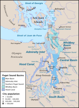
The USGS defines Puget Sound as all the waters south of three entrances from the Strait of Juan de Fuca. The main entrance at Admiralty Inlet is defined as a line between Point Wilson on the Olympic Peninsula, and Point Partridge on Whidbey Island. The second entrance is at Deception Pass along a line from West Point on Whidbey Island, to Deception Island, then to Rosario Head on Fidalgo Island. The third entrance is at the south end of the Swinomish Channel, which connects Skagit Bay and Padilla Bay.[10] Under this definition, Puget Sound includes the waters of Hood Canal, Admiralty Inlet, Possession Sound, Saratoga Passage, and others. It does not include Bellingham Bay, Padilla Bay, the waters of the San Juan Islands or anything farther north.
Another definition, given by NOAA, subdivides Puget Sound into five basins or regions. Four of these (including South Puget Sound) correspond to areas within the USGS definition, but the fifth, called "Northern Puget Sound" includes a large additional region. It is defined as bounded to the north by the international boundary with Canada, and to the west by a line running north from the mouth of the Sekiu River on the Olympic Peninsula.[11] Under this definition, significant parts of the Strait of Juan de Fuca and the Strait of Georgia are included in Puget Sound, with the international boundary marking an abrupt and hydrologically arbitrary limit.
According to Arthur Kruckeberg, the term "Puget Sound" is sometimes used for waters north of Admiralty Inlet and Deception Pass, especially for areas along the north coast of Washington and the San Juan Islands, essentially equivalent to NOAA's "Northern Puget Sound" subdivision described above. Kruckeberg uses the term "Puget Sound and adjacent waters".[7] Kruckeberg's 1991 text, however, does not reflect the 2009 decision of the United States Board on Geographic Names to use the term Salish Sea to refer to the greater maritime environment.
Geology edit

Continental ice sheets have repeatedly advanced and retreated from the Puget Sound region. The most recent glacial period, called the Fraser Glaciation, had three phases, or stades. During the third, or Vashon Glaciation, a lobe of the Cordilleran Ice Sheet, called the Puget Lobe, spread south about 15,000 years ago, covering the Puget Sound region with an ice sheet about 3,000 feet (910 m) thick near Seattle, and nearly 6,000 feet (1,800 m) at the present Canada-U.S. border. Since each new advance and retreat of ice erodes away much of the evidence of previous ice ages, the most recent Vashon phase has left the clearest imprint on the land. At its maximum extent the Vashon ice sheet extended south of Olympia to near Tenino, and covered the lowlands between the Olympic and Cascade mountain ranges. About 14,000 years ago the ice began to retreat. By 11,000 years ago it survived only north of the Canada–US border.[12]
The melting retreat of the Vashon Glaciation eroded the land, creating a drumlin field of hundreds of aligned drumlin hills. Lake Washington and Lake Sammamish (which are ribbon lakes), Hood Canal, and the main Puget Sound basin were altered by glacial forces. These glacial forces are not specifically "carving", as in cutting into the landscape via the mechanics of ice/glaciers, but rather eroding the landscape from melt water of the Vashon Glacier creating the drumlin field. As the ice retreated, vast amounts of glacial till were deposited throughout the Puget Sound region.[12] The soils of the region, less than ten thousand years old, are still characterized as immature.
As the Vashon glacier receded a series of proglacial lakes formed, filling the main trough of Puget Sound and inundating the southern lowlands. Glacial Lake Russell was the first such large recessional lake. From the vicinity of Seattle in the north the lake extended south to the Black Hills, where it drained south into the Chehalis River.[13] Sediments from Lake Russell form the blue-gray clay identified as the Lawton Clay. The second major recessional lake was Glacial Lake Bretz. It also drained to the Chehalis River until the Chimacum Valley, in the northeast Olympic Peninsula, melted, allowing the lake's water to rapidly drain north into the marine waters of the Strait of Juan de Fuca, which was rising as the ice sheet retreated.[13]
As icebergs calved off the toe of the glacier, their embedded gravels and boulders were deposited in the chaotic mix of unsorted till geologists call glaciomarine drift. Many beaches about the Sound display glacial erratics, rendered more prominent than those in coastal woodland solely by their exposed position; submerged glacial erratics sometimes cause hazards to navigation. The sheer weight of glacial-age ice depressed the landforms, which experienced post-glacial rebound after the ice sheets had retreated. Because the rate of rebound was not synchronous with the post-ice age rise in sea levels, the bed of what is now Puget Sound filled alternately with fresh and with sea water. The upper level of the lake-sediment Lawton Clay now lies about 120 feet (37 m) above sea level.

The Puget Sound system consists of four deep basins connected by shallower sills. The four basins are Hood Canal, west of the Kitsap Peninsula, Whidbey Basin, east of Whidbey Island, South Sound, south of the Tacoma Narrows, and the Main Basin, which is further subdivided into Admiralty Inlet and the Central Basin.[14] Puget Sound's sills, a kind of submarine terminal moraine, separate the basins from one another, and Puget Sound from the Strait of Juan de Fuca. Three sills are particularly significant—the one at Admiralty Inlet which checks the flow of water between the Strait of Juan de Fuca and Puget Sound, the one at the entrance to Hood Canal (about 175 ft or 53 m below the surface), and the one at the Tacoma Narrows (about 145 ft or 44 m). Other sills that present less of a barrier include the ones at Blake Island, Agate Pass, Rich Passage, and Hammersley Inlet.[7]
The depth of the basins is a result of the Sound being part of the Cascadia subduction zone, where the terranes accreted at the edge of the Juan de Fuca Plate are being subducted under the North American Plate. There has not been a major subduction zone earthquake here since the magnitude nine Cascadia earthquake; according to Japanese records, it occurred on January 26, 1700. Lesser Puget Sound earthquakes with shallow epicenters, caused by the fracturing of stressed oceanic rocks as they are subducted, still cause great damage. The Seattle Fault cuts across Puget Sound, crossing the southern tip of Bainbridge Island and under Elliott Bay.[15][better source needed] To the south, the existence of a second fault, the Tacoma Fault, has buckled the intervening strata in the Seattle Uplift.
Typical Puget Sound profiles of dense glacial till overlying permeable glacial outwash of gravels above an impermeable bed of silty clay may become unstable after periods of unusually wet weather and slump in landslides.[16]
Hydrology edit

The United States Geological Survey (USGS) defines Puget Sound as a bay with numerous channels and branches; more specifically, it is a fjord system of flooded glacial valleys. Puget Sound is part of a larger physiographic structure termed the Puget Trough, which is a physiographic section of the larger Pacific Border province, which in turn is part of the larger Pacific Mountain System.[17]
Puget Sound is a large salt water estuary, or system of many estuaries, fed by highly seasonal freshwater from the Olympic and Cascade Mountain watersheds. The mean annual river discharge into Puget Sound is 41,000 cubic feet per second (1,200 m3/s), with a monthly average maximum of about 367,000 cubic feet per second (10,400 m3/s) and minimum of about 14,000 cubic feet per second (400 m3/s). Puget Sound's shoreline is 1,332 miles (2,144 km) long, encompassing a water area of 1,020 square miles (2,600 km2) and a total volume of 26.5 cubic miles (110 km3) at mean high water. The average volume of water flowing in and out of Puget Sound during each tide is 1.26 cubic miles (5.3 km3). The maximum tidal currents, in the range of 9 to 10 knots, occurs at Deception Pass.[3] Water flow through Deception Pass is approximately equal to 2% of the total tidal exchange between Puget Sound and the Strait of Juan de Fuca.[3]

The size of Puget Sound's watershed is 12,138 sq mi (31,440 km2).[4] "Northern Puget Sound" is frequently considered part of the Puget Sound watershed, which enlarges its size to 13,700 sq mi (35,000 km2).[18] The USGS uses the name "Puget Sound" for its hydrologic unit subregion 1711, which includes areas draining to Puget Sound proper as well as the Strait of Juan de Fuca, the Strait of Georgia, and the Fraser River.[19] Significant rivers that drain to "Northern Puget Sound" include the Nooksack, Dungeness, and Elwha Rivers. The Nooksack empties into Bellingham Bay, the Dungeness and Elwha into the Strait of Juan de Fuca. The Chilliwack River flows north to the Fraser River in Canada.
Tides in Puget Sound are of the mixed type with two high and two low tides each tidal day. These are called Higher High Water (HHW), Lower Low Water (LLW), Lower High Water (LHW), and Higher Low Water (HLW). The configuration of basins, sills, and interconnections cause the tidal range to increase within Puget Sound. The difference in height between the Higher High Water and the Lower Low Water averages about 8.3 feet (2.5 m) at Port Townsend on Admiralty Inlet, but increases to about 14.4 feet (4.4 m) at Olympia, the southern end of Puget Sound.[3]
Puget Sound is generally accepted as the start of the Inside Passage.[20][21]
Flora and fauna edit
Important marine flora of Puget Sound include eelgrass (Zostera marina)[22] and various kelp, important kelps include canopy forming bull kelp (Nereocystis luetkeana).[23] and edible kelps like kombu (Saccharina latissima)[24]

Among the marine mammals species found in Puget Sound are harbor seals (Phoca vitulina).[25] Orca (Orcinus orca), or "killer whales" are famous throughout the Sound, and are a large tourist attraction. Although orca are sometimes seen in Puget Sound proper they are far more prevalent around the San Juan Islands north of Puget Sound.[26]
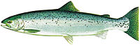
Many fish species occur in Puget Sound. The various salmonid species, including salmon, trout, and char are particularly well-known and studied. Salmonid species of Puget Sound include chinook salmon (Oncorhynchus tshawytscha), chum salmon (O. keta), coho salmon (O. kisutch), pink salmon (O. gorbuscha), sockeye salmon (O. nerka), sea-run coastal cutthroat trout (O. clarki clarki), steelhead (O. mykiss irideus), sea-run bull trout (Salvelinus confluentus), and Dolly Varden trout (Salvelinus malma malma).[27][28]
Common forage fishes found in Puget Sound include Pacific herring (Clupea pallasii), surf smelt (Hypomesus pretiosus), and Pacific sand lance (Ammodytes hexapterus).[29] Important benthopelagic fish of Puget Sound include North Pacific hake (Merluccius productus), Pacific cod (Gadus macrocelhalus), walleye pollock (Theragra chalcogramma), and the spiny dogfish (Squalus acanthias).[30] There are about 28 species of Sebastidae (rockfish), of many types, found in Puget Sound. Among those of special interest are copper rockfish (Sebastes caurinus), quillback rockfish (S. maliger), black rockfish (S. melanops), yelloweye rockfish (S. ruberrimus), bocaccio rockfish (S. paucispinis), canary rockfish (S. pinniger), and Puget Sound rockfish (S. emphaeus).[31]
Many other fish species occur in Puget Sound, such as sturgeons, lampreys, various sharks, rays, and skates.[32]
Puget Sound is home to numerous species of marine invertebrates, including sponges, sea anemones, chitons, clams, sea snails, limpets, crabs, barnacles, starfish, sea urchins, and sand dollars.[33] Dungeness crabs (Metacarcinus magister) occur throughout Washington waters, including Puget Sound.[34] Many bivalves occur in Puget Sound, such as Pacific oysters (Crassostrea gigas) and geoduck clams (Panopea generosa). The Olympia oyster (Ostreola conchaphila), once common in Puget Sound, was depleted by human activities during the 20th century. There are ongoing efforts to restore Olympia oysters in Puget Sound.[35]
In 1967, an initial scuba survey estimated that were "about 110 million pounds of geoducks" (pronounced "gooey ducks") situated in Puget Sound's sediments.[36] Also known as "king clam", geoducks are considered to be a delicacy in Asian countries.
There are many seabird species of Puget Sound. Among these are grebes such as the western grebe (Aechmophorus occidentalis); loons such as the common loon (Gavia immer); auks such as the pigeon guillemot (Cepphus columba), rhinoceros auklet (Cerorhinca monocerata), common murre (Uria aalge), and marbled murrelet (Brachyramphus marmoratus); the brant goose (Branta bernicla); seaducks such as the long-tailed duck (Clangula hyemalis), harlequin duck (Histrionicus histrionicus), and surf scoter (Melanitta perspicillata); and cormorants such as the double-crested cormorant (Phalacrocorax auritus). Puget Sound is home to a non-migratory and marine-oriented subspecies of great blue herons (Ardea herodias fannini).[37] Bald eagles (Haliaeetus leucocephalus) occur in relative high densities in the Puget Sound region.[38]
History edit

Puget Sound has been home to many Indigenous peoples, such as the Lushootseed-speaking peoples, as well as the Twana, Chimakum, and Klallam, for millennia. The earliest known presence of Indigenous inhabitants in the Puget Sound region is between 14,000 BCE to 6,000 BCE.[39]

Dispatched in an attempt to locate the fabled Northwest Passage, British Royal Navy captain George Vancouver anchored on May 19, 1792, on the shores of Seattle, explored Puget Sound, and claimed it for Great Britain on June 4 the same year, naming it for one of his officers, Lieutenant Peter Puget. He further named the entire region; New Georgia, after King George III.[40][41] After 1818 Britain and the United States, which both claimed the Oregon Country, agreed to "joint occupancy", deferring resolution of the Oregon boundary dispute until the 1846 Oregon Treaty. Puget Sound was part of the disputed region until 1846, after which it became US territory.
American maritime fur traders visited Puget Sound in the early 19th century.[42]
An Hudson's Bay Company expedition led by James McMillan in late 1824 was first non-Indigenous group to enter Puget Sound since George Vancouver in 1792. The expedition went on to reach the Fraser River, first again to reach the lower Fraser since Fraser himself in 1808.[43]
The first non-Indigenous settlement in the Puget Sound area was Fort Nisqually, a fur trade post of the Hudson's Bay Company (HBC) built in 1833.[44] Fort Nisqually was part of the HBC's Columbia District, headquartered at Fort Vancouver. In 1838, the HBC's subsidy operation, the Puget Sound Agricultural Company was established in part to procure resources and trade, as well as to further establish British claim to the region.[45] Missionaries J.P. Richmond and W.H. Wilson were attending Fort Nisqually for two years by 1840.[46] British ships, such as the Beaver, exported foodstuffs and provisions from Fort Nisqually, and would eventually export Puget Sound lumber, an industry that would soon outpace the dominant fur trading market and drive the early Puget Sound economy.[47][48]
The first organized American expedition took place under the helm of Commander Charles Wilkes, whose exploring party sailed up Puget Sound in 1841. The first permanent American settlement on Puget Sound was Tumwater, founded in 1845 by Americans who had come via the Oregon Trail. The decision to settle north of the Columbia River was made in part because one of the settlers, George Washington Bush, was considered black and the Provisional Government of Oregon banned the residency of mulattoes but did not actively enforce the restriction north of the river.[49] In 1853 Washington Territory was formed from part of Oregon Territory.[50] In 1888 the Northern Pacific railroad line reached Puget Sound, linking the region to eastern states.[51] Washington State was admitted to the union in 1889 as part of the Enabling Act, and the regions borders have since remained unchanged.[52]
Transportation edit

The Washington State Ferries (WSF) are a state-run ferry system that connects the larger islands of Puget Sound the Washington mainland, and the Olympic and Kitsap Peninsulas. Its vessels carry both passengers and vehicular traffic. The system averaged 24.3 million passengers in the 2010s[53] and 17.2 in 2022 with the COVID-19 pandemic.[54] It is the largest ferry operator in the United States.[53]
Environmental issues edit
Over the past 30 years, as the human population of the region has increased, there has been a correlating decrease in various plant and animal species which inhabit Puget Sound. The decline has been seen in numerous populations including forage fish, salmonids, bottom fish, marine birds, harbor porpoise, and orcas. The decline is attributed to a variety of issues, including human population growth, pollution, and climate change.[55] Because of this population decline, there have been changes to the fishery practices, and an increase in petitioning to add species to the Endangered Species Act. There has also been an increase in recovery and management plans for many different area species.[56]
The causes of these environmental issues are toxic contamination, eutrophication (low oxygen due to excess nutrients), and near shore habitat changes.[56]
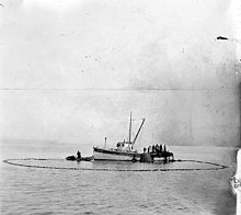
On May 22, 1978, a valve was mistakenly opened aboard the submarine USS Puffer, releasing up to 500 US gallons (1,900 L; 420 imp gal) of radioactive water into Puget Sound, during an overhaul in drydock at Bremerton Naval Shipyard.[57]
See also edit
- Back-arc basin – Submarine features associated with island arcs and subduction zones
- Fjords of Canada
- Fjords of the United States
- Puget Sound AVA
- Seattle metropolitan area – metropolitan area in Washington State, United States
References edit
- ^ a b c Zalmai, Zahir (2009). A Lushootseed Analysis of a 1877 Dictionary by George Gibbs (PDF). Zahir Consulting Services. p. 218.
- ^ a b c Bates, Dawn; Hess, Thom; Vi, Hilbert (January 1, 1994). Lushootseed Dictionary. Seattle: University of Washington Press. ISBN 9780295973234.
- ^ a b c d e f g h Lincoln, John H. "The Puget Sound Model Summary". Pacific Science Center. Archived from the original on 10 March 2015. Retrieved 6 August 2014.
- ^ a b "Watershed Boundary Dataset". USDA, NRCS, National Cartography and Geospatial Center. Archived from the original on October 8, 2010. Retrieved September 6, 2010. ArcExplorer GIS data viewer.
- ^ "Basic Information about Estuaries". United States Environmental Protection Agency. Archived from the original on November 29, 2012. Retrieved August 6, 2014.
- ^ "Saving the Sound". Washington State Department of Ecology. Archived from the original on August 8, 2014. Retrieved August 6, 2014.
- ^ a b c Kruckeberg 1991, pp. 61–64
- ^ "Saving Puget Sound". Washington State Department of Ecology. Archived from the original on June 22, 2016. Retrieved June 15, 2016.
- ^ Kruckeberg 1991, pp. 427–428
- ^ "Puget Sound". Geographic Names Information System. United States Geological Survey, United States Department of the Interior.
- ^ Environmental History and Features of Puget Sound Archived May 13, 2009, at the Wayback Machine, see also: Map of subareas of Puget Sound Archived May 13, 2009, at the Wayback Machine, National Oceanic and Atmospheric Administration and National Marine Fisheries Service
- ^ a b Kruckeberg 1991, pp. 18–23
- ^ a b Baum, Rex L.; Godt, Jonathan W.; Highland, Lynn (2008). Landslides and engineering geology of the Seattle, Washington, area. Volume 20 of Reviews in engineering geology. Geological Society of America. pp. 12–13. ISBN 978-0-8137-4120-8. Archived from the original on September 2, 2016. Retrieved May 7, 2016.
- ^ "Features of Puget Sound Region: Oceanography and P" (PDF). Seattle: King County Department of Natural Resources. 2001. Archived (PDF) from the original on December 22, 2014. Retrieved August 6, 2014.
- ^ "Folds at surface show ancient seismic stresses still at work in Washington". University of Washington. June 1, 2004. Retrieved March 26, 2024.
- ^ "Puget Sound landslides". Washington State Department of Ecology. Archived from the original on August 16, 2006.
- ^ "Physiographic divisions of the conterminous U. S." U.S. Geological Survey. Archived from the original on December 5, 2007. Retrieved December 6, 2007.
- ^ "Puget Sound Basin NAWQA". USGS. Archived from the original on June 7, 2014. Retrieved August 6, 2014.
- ^ "List Hydrologic Unit Codes (HUCs) – USGS Washington". USGS. Archived from the original on June 7, 2014. Retrieved August 6, 2014.
- ^ Merriam-Webster, Richard (2000). Merriam-Webster's Collegiate Encyclopedia. Merriam-Webster. p. 808. ISBN 978-0-87779-017-4. Archived from the original on March 17, 2016. Retrieved May 7, 2016.
- ^ Manning, Richard (2001). Inside Passage: A Journey Beyond Borders. Island Press. p. 113. ISBN 978-1-55963-655-1. Archived from the original on September 2, 2016. Retrieved May 7, 2016.
- ^ "Eelgrass". Encyclopedia of Puget Sound. Archived from the original on October 26, 2014. Retrieved August 6, 2014.
- ^ "Kelp". Encyclopedia of Puget Sound. Archived from the original on October 26, 2014. Retrieved August 6, 2014.
- ^ "Sugar Kelp, Kombu, Sugar Wrack – Seaweeds of the Pacific Northwest". Seaweeds of the Pacific Northwest. September 30, 2018. Retrieved February 7, 2022.
- ^ "Harbor seals". Encyclopedia of Puget Sound. Archived from the original on October 26, 2014. Retrieved August 6, 2014.
- ^ "Killer Whales". Encyclopedia of Puget Sound. Archived from the original on October 26, 2014. Retrieved August 6, 2014.
- ^ "Salmonids". Encyclopedia of Puget Sound. Archived from the original on October 26, 2014. Retrieved August 6, 2014.
- ^ "Puget Sound Shorelines: Salmon". Washington Department of Ecology. Archived from the original on 13 November 2014. Retrieved 6 August 2014.
- ^ "Forage Fishes". Encyclopedia of Puget Sound. Archived from the original on August 8, 2014. Retrieved August 6, 2014.
- ^ "Bentho-Pelagic Fish". Encyclopedia of Puget Sound. Archived from the original on October 26, 2014. Retrieved August 6, 2014.
- ^ "Rockfish". Encyclopedia of Puget Sound. Archived from the original on October 26, 2014. Retrieved August 6, 2014.
- ^ "Taxonomic List of Puget Sound Fishes". Burke Museum. Archived from the original on July 15, 2014. Retrieved August 6, 2014.
- ^ Kruckeberg 1991, p. 79
- ^ "Dungeness Crabs". Encyclopedia of Puget Sound. Archived from the original on August 8, 2014. Retrieved August 6, 2014.
- ^ "Bivalves". Encyclopedia of Puget Sound. Archived from the original on October 26, 2014. Retrieved August 6, 2014.
- ^ "Commercial wild stock geoduck clam fishery". Washington Department of Fish & Wildlife. History of the fishery. Retrieved March 13, 2024.
- ^ "Marine birds". Encyclopedia of Puget Sound. Archived from the original on October 26, 2014. Retrieved August 6, 2014.
- ^ "Bald eagles". Encyclopedia of Puget Sound. Archived from the original on October 26, 2014. Retrieved August 6, 2014.
- ^ Kopperl, Robert E.; Taylor, Amanda K.; Miss, Christian J.; Ames, Kenneth M.; Hodges, Charles M. (2015). "The Bear Creek Site (45KI839), a Late Pleistocene–Holocene Transition Occupation in the Puget Sound Lowland, King County, Washington". PaleoAmerica. 1 (1): 116–120. doi:10.1179/2055556314Z.0000000004. ISSN 2055-5563.
- ^ "Territorial Timeline: While searching for the Northwest Passage, Captain George Vancouver explores Puget Sound and names the bordering land New Georgia". Washington State Archives. July 6, 2022. Archived from the original on April 15, 2023.
- ^ Hayes, Derek (1999). "Vancouver on the Northwest Coast". Historical atlas of the Pacific Northwest: maps of exploration and discovery: British Columbia, Washington, Oregon, Alaska, Yukon. Seattle: Sasquatch Books. p. 85–86. ISBN 978-1-57061-215-2. OCLC 40813256 – via Internet Archive.
- ^ Mackie 1997, pp. 146Archived December 11, 2013, at the Wayback Machine
- ^ Williams, David B. (March 19, 2020). "Hudson's Bay Company builds Fort Nisqually in spring 1833". HistoryLink. Essay 20999. Retrieved March 21, 2024.
- ^ "History of Fort Nisqually". Metro Parks Tacoma. Archived from the original on August 10, 2014. Retrieved August 6, 2014.
- ^ Galbraith, John S. (September 1954). "The Early History of the Puget's Sound Agricultural Company, 1838-43". Oregon Historical Quarterly. 55 (3). Oregon Historical Society: 234–259. ISSN 0030-4727. JSTOR 20612147. Archived from the original on June 4, 2021 – via JSTOR.
- ^ Meany, Edmond S. (April 1916). "First American Settlement on Puget Sound". The Washington Historical Quarterly. 7 (2). University of Washington: 136–143. ISSN 0361-6223. JSTOR 40474609. Archived from the original on August 15, 2020 – via JSTOR.
- ^ Mackie 1997, pp. 235–239.
- ^ Buchanan, Iva L. (January 1936). "Lumbering and Logging in the Puget Sound Region in Territorial Days". The Pacific Northwest Quarterly. 27 (1). University of Washington: 34–53. ISSN 0030-8803. JSTOR 20698094. Archived from the original on June 4, 2021 – via JSTOR.
- ^ "City of Tumwater, WA: History". City of Tumwater, WA. June 21, 2014. Archived from the original on August 21, 2014.
- ^ "Settlers met at Monticello to sign a petition asking Congress to create a separate territory north of the Columbia River". Washington State Archives. Washington Secretary of State. Archived from the original on December 24, 2013. Retrieved March 23, 2024.
- ^ Oldham, Kit (March 5, 2003). "First trains cross the Northern Pacific Railroad bridge spanning the Columbia River between Pasco and Kennewick on December 3, 1887". HistoryLink. Essay 5365. Archived from the original on August 8, 2014. Retrieved March 23, 2024.
- ^ Utter, Robert F.; Spitzer, Hugh D. (2013) [2002]. The Washington State Constitution. New York, NY: Oxford University Press. p. 252. ISBN 978-0-19-930067-9. OCLC 852158872.
- ^ a b "Washington State Ferries Fact Sheet" (PDF). Washington State Department of Transportation. January 2023. Retrieved March 23, 2024.
- ^ Washington State Department of Transportation, Ferries Division (December 28, 2022). "FY 2022 WSDOT Ferries Division Performance Report" (PDF). Retrieved March 23, 2024.
- ^ "Health of the Salish Sea Ecosystem Report". Environmental Protection Agency. May 13, 2013. Retrieved July 10, 2022.
- ^ a b "2007 Puget Sound Update: Ninth Report of the Puget Sound Ambient Monitoring Program". Washington Department of Fish and Wildlife. Archived from the original on July 26, 2014. Retrieved August 6, 2014.
- ^ Kaplan, David B. (August 1983). "The Silent Saga of the Nuclear Navy". Oceans Magazine. Archived from the original on August 27, 2019. Retrieved August 27, 2019.
Sources edit
- Kruckeberg, Arthur R. (1991). The Natural History of Puget Sound Country. Seattle: University of Washington Press. ISBN 978-0-295-97019-6. OCLC 1345617769 – via Internet Archive.
- Mackie, Richard Somerset (1997). Trading beyond the mountains: the British fur trade on the Pacific, 1793–1843. UBC Press. ISBN 978-0-7748-0613-8. OCLC 180704193.
Further reading edit
- Jones, M. A. (1999). Geologic framework for the Puget Sound aquifer system, Washington and British Columbia. Reston, Virginia: US Geological Survey. p. 44. doi:10.3133/pp1424c. ISSN 2330-7102. OCLC 896811412. 1424C.
- Jovanelly, Tamie J.; Moore, Andrew L. (2009). "Sedimentological Analysis of an Ancient Sand Sheet of Multiple Origins at Lynch Cove, Puget Sound, Washington". Journal of Coastal Research. 25 (2): 294–304. doi:10.2112/07-0892.1. JSTOR 27698322. S2CID 128926730.
- LeWarne, Charles Pierce (1995). Utopias on Puget Sound, 1885-1915. Seattle: University of Washington Press. ISBN 978-0-295-74105-5. OCLC 47010928 – via Internet Archive.
- Morgan, Murray (1979). Puget's Sound: A Narrative of Early Tacoma and the Southern Sound. Seattle: University of Washington Press. ISBN 978-0-295-95680-0. OCLC 1036792658 – via Internet Archive. Reprinted in 2018: ISBN 978-0-295-74423-0 JSTOR j.ctvcwn271
- Prosser, William Farrand (1903). A History of The Puget Sound Country Its Resources, Its Commerce and Its People: With Some Reference to Discoveries and Explorations in North America from the Time of Christopher Columbus Down to That of George Vancouver in 1792. New York: Lewis Pub. Co. OCLC 679331240 – via Internet Archive. Also available online History of the Puget Sound country. Vol. 1 – via Washington State Library. Reprinted: ISBN 978-0-266-41119-2
External links edit
 Definitions from Wiktionary
 Media from Commons
 Travel information from Wikivoyage
- University of Washington Libraries Digital Collections – Oliver S. Van Olinda Photographs A collection of 420 photographs depicting life on Vashon Island, Whidbey Island, Seattle, and other communities of Washington State's Puget Sound from the 1880s through the 1930s.
- "Geology of Puget Sound". Pacific Science Center. September 10, 2005. Archived from the original on February 9, 2006.
- Torresan, Laura Zink (April 4, 2005). "Puget Sound Earthquake Origin and Occurrence". U.S. Geological Survey. Archived from the original on May 27, 2006.
- "Features of Puget Sound Region: Oceanography and Physical Processes" (PDF). Reconnaissance Assessment of the State of the Nearshore Report Including Vashon and Maury Islands (WRIAs 8 and 9). King County, Washington. May 2001. Retrieved March 12, 2024.