
KNOWPIA
WELCOME TO KNOWPIA

National Register of Historic Places listings in Queen Anne's County, Maryland 
Summary
This is a list of the National Register of Historic Places listings in Queen Anne's County, Maryland.

This is intended to be a complete list of the properties and districts on the National Register of Historic Places in Queen Anne's County, Maryland, United States. Latitude and longitude coordinates are provided for many National Register properties and districts; these locations may be seen together in a map.[1]
There are 40 properties and districts listed on the National Register in the county.
| Allegany - Anne Arundel - Baltimore (city) - Baltimore County - Calvert - Caroline - Carroll - Cecil - Charles - Dorchester - Frederick - Garrett - Harford - Howard - Kent - Montgomery - Prince George's - Queen Anne's - Somerset - St. Mary's - Talbot - Washington - Wicomico - Worcester |
This National Park Service list is complete through NPS recent listings posted April 12, 2024.[2]
Current listings edit
| [3] | Name on the Register | Image | Date listed[4] | Location | City or town | Description |
|---|---|---|---|---|---|---|
| 1 | Bachelor's Hope |  |
May 3, 1984 (#84001855) |
Maryland Route 18 39°02′01″N 76°06′18″W / 39.033611°N 76.105°W | Centreville | |
| 2 | Bishopton |  |
September 12, 1985 (#85002194) |
Pinder Hill Rd. 39°09′35″N 75°58′26″W / 39.159722°N 75.973889°W | Church Hill | |
| 3 | Bloomingdale | 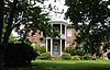 |
October 18, 1972 (#72001457) |
Bloomingdale Rd. and U.S. Route 50 38°58′21″N 76°07′01″W / 38.9725°N 76.116944°W | Queenstown | |
| 4 | Bowlingly |  |
August 21, 1972 (#72001458) |
Off Maryland Route 18 38°59′36″N 76°09′30″W / 38.993333°N 76.158333°W | Queenstown | |
| 5 | Captain's Houses |  |
November 17, 1980 (#80001830) |
Corsica St. 39°03′07″N 76°04′32″W / 39.051944°N 76.075556°W | Centreville | |
| 6 | Centreville Armory | 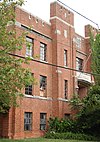 |
September 25, 1985 (#85002666) |
S. Commerce St. 39°02′30″N 76°04′05″W / 39.041667°N 76.068056°W | Centreville | |
| 7 | Centreville Historic District |  |
November 13, 2004 (#04001218) |
Roughly bounded by the Corsica River, Chesterfield Ave, Liberty St, Banjo Ln, Railroad Ave, town limits, and Mill Stream 39°02′45″N 76°04′02″W / 39.045833°N 76.067222°W | Centreville | |
| 8 | Chester Hall |  |
January 18, 1980 (#80001831) |
1 mile southeast of Chestertown on Maryland Route 213 39°12′17″N 76°02′43″W / 39.204722°N 76.045278°W | Chestertown | |
| 9 | Christ Church |  |
July 24, 1979 (#79003268) |
Maryland Route 18 38°58′50″N 76°18′52″W / 38.980556°N 76.314444°W | Stevensville | |
| 10 | Churchill Theatre-Community Building |  |
September 8, 2000 (#00001051) |
Maryland Route 19 39°08′31″N 75°59′06″W / 39.141944°N 75.985°W | Church Hill | |
| 11 | Jackson Collins House | 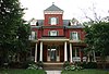 |
December 13, 2000 (#00001503) |
201 S. Commerce St. 39°02′34″N 76°03′58″W / 39.04285°N 76.06609°W | Centreville | |
| 12 | Content |  |
February 13, 1986 (#86000256) |
Maryland Route 305 near Tanyard Rd. 39°02′30″N 76°01′17″W / 39.041667°N 76.021389°W | Centreville | |
| 13 | Cray House |  |
May 9, 1983 (#83002960) |
Cockey's Lane 38°58′53″N 76°18′56″W / 38.981389°N 76.315556°W | Stevensville | |
| 14 | Delaware Boundary Markers | February 18, 1975 (#75002101) |
Boundary line dividing Delaware from Maryland and Pennsylvania Coordinates missing | Multiple | Extends into Delaware and southeastern Pennsylvania. | |
| 15 | Dudley's Chapel |  |
November 15, 1979 (#79003124) |
Southwest of Sudlersville off Maryland Route 300 39°10′56″N 75°53′33″W / 39.182222°N 75.8925°W | Sudlersville | |
| 16 | John Embert Farm |  |
June 22, 1980 (#80001832) |
Southeast of Millington on Baxter Rd., 0.6 miles east of Peters Comer Rd. 39°13′30″N 75°48′40″W / 39.225°N 75.811111°W | Millington | |
| 17 | Female Seminary |  |
December 10, 2003 (#03001266) |
205-207 S. Commerce St. 39°02′32″N 76°03′59″W / 39.04234°N 76.06639°W | Centreville | |
| 18 | Friendship |  |
July 15, 1994 (#94000727) |
200 Friendship Manor Dr. 38°57′12″N 76°20′43″W / 38.953333°N 76.345278°W | Stevensville | |
| 19 | Hawkins Pharsalia |  |
December 20, 1984 (#84000458) |
Maryland Route 304 39°01′02″N 75°55′06″W / 39.017222°N 75.918333°W | Ruthsburg | |
| 20 | Keating House |  |
October 28, 1999 (#99001281) |
208 S. Liberty St. 39°02′35″N 76°04′05″W / 39.04298°N 76.06796°W | Centreville | |
| 21 | Kennersley |  |
May 19, 1983 (#83002961) |
Clabber Hill Rd. 39°08′46″N 76°01′58″W / 39.146111°N 76.032778°W | Church Hill | |
| 22 | Lansdowne |  |
June 7, 1984 (#84001858) |
Maryland Route 305 39°02′49″N 75°59′26″W / 39.046944°N 75.990556°W | Centreville | |
| 23 | Legg's Dependence |  |
November 8, 2003 (#03001116) |
0200 Long Creek Court 38°55′13″N 76°20′46″W / 38.920278°N 76.346111°W | Stevensville | |
| 24 | Lexon | 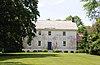 |
May 4, 1990 (#90000726) |
Corsica Neck Rd. southwest of Earle Cove 39°03′16″N 76°05′15″W / 39.054444°N 76.0875°W | Centreville | |
| 25 | Mattapax |  |
December 10, 1998 (#98001498) |
106 Shipping Creek Rd. 38°54′40″N 76°20′54″W / 38.911111°N 76.348333°W | Stevensville | |
| 26 | MYSTERY (log canoe) | September 18, 1985 (#85002250) |
Round Top Rd. 39°12′29″N 76°02′16″W / 39.208056°N 76.037778°W | Kingstown | ||
| 27 | Capt. John H. Ozmon Store | 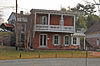 |
February 14, 1985 (#85000277) |
Centreville Wharf 39°03′12″N 76°04′28″W / 39.053333°N 76.074444°W | Centreville | |
| 28 | Readbourne |  |
April 11, 1973 (#73002134) |
5.4 miles northwest of Centreville 39°07′38″N 76°05′26″W / 39.127222°N 76.090556°W | Centreville | |
| 29 | Reed's Creek Farm |  |
July 7, 1975 (#75002106) |
West of Centreville on Wright's Neck Rd. off Maryland Route 18 39°03′05″N 76°09′12″W / 39.051389°N 76.153333°W | Centreville | |
| 30 | St. Andrew's Episcopal Chapel |  |
September 7, 1984 (#84001853) |
Church St. and Maple Ave. 39°11′06″N 75°51′30″W / 39.185°N 75.858333°W | Sudlersville | |
| 31 | St. Luke's Church | 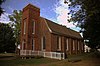 |
November 23, 1977 (#77001505) |
Junction of Maryland Routes 19 and 213 39°08′32″N 75°59′11″W / 39.142222°N 75.986389°W | Church Hill | |
| 32 | St. Peter's Church |  |
March 10, 1980 (#80001833) |
Southeast of Queenstown on U.S. Route 50 38°58′41″N 76°08′03″W / 38.978056°N 76.134167°W | Queenstown | |
| 33 | Starr Church | March 1, 2024 (#100009979) |
1504 Starr Road 38°58′31″N 76°00′26″W / 38.9754°N 76.00734°W | Centreville | ||
| 34 | Stevensville Bank |  |
January 3, 1985 (#85000020) |
Love Point Rd. 38°58′55″N 76°18′53″W / 38.981944°N 76.314722°W | Stevensville | |
| 35 | Stevensville Historic District | 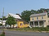 |
September 11, 1986 (#86002333) |
Maryland Route 18 and Love Point Rd. 38°58′53″N 76°18′49″W / 38.981389°N 76.313611°W | Stevensville | |
| 36 | Stratton |  |
December 18, 2003 (#03001294) |
3102 Ruthsburg Rd. 39°01′41″N 75°53′51″W / 39.028056°N 75.8975°W | Centreville | |
| 37 | Thomas House |  |
May 13, 1976 (#76002150) |
1.8 miles northeast of Ruthsburg on Maryland Route 304 39°00′54″N 75°55′53″W / 39.015°N 75.931389°W | Ruthsburg | |
| 38 | Wilton | 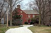 |
December 12, 1977 (#77001506) |
North of Wye Mills on Maryland Route 213 38°56′58″N 76°04′37″W / 38.949444°N 76.076944°W | Wye Mills | |
| 39 | Wye Hall |  |
November 2, 2015 (#15000759) |
505 Wye Hall Dr. 38°53′20″N 76°07′07″W / 38.8888°N 76.1187°W | Queenstown | |
| 40 | Wye Mill | 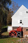 |
April 9, 1985 (#85000717) |
Maryland Route 662 38°56′29″N 76°04′53″W / 38.941389°N 76.081389°W | Wye Mills | Extends into Talbot County |
See also edit
Wikimedia Commons has media related to National Register of Historic Places in Queen Anne's County, Maryland.
References edit
- ^ The latitude and longitude information provided in this table was derived originally from the National Register Information System, which has been found to be fairly accurate for about 99% of listings. Some locations in this table may have been corrected to current GPS standards.
- ^ National Park Service, United States Department of the Interior, "National Register of Historic Places: Weekly List Actions", retrieved April 12, 2024.
- ^ Numbers represent an alphabetical ordering by significant words. Various colorings, defined here, differentiate National Historic Landmarks and historic districts from other NRHP buildings, structures, sites or objects.
- ^ The eight-digit number below each date is the number assigned to each location in the National Register Information System database, which can be viewed by clicking the number.