
KNOWPIA
WELCOME TO KNOWPIA

National Register of Historic Places listings in Worcester County, Maryland 
Summary
This is a list of the National Register of Historic Places listings in Worcester County, Maryland.
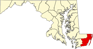
This is intended to be a complete list of the properties and districts on the National Register of Historic Places in Worcester County, Maryland, United States. Latitude and longitude coordinates are provided for many National Register properties and districts; these locations may be seen together in a map.[1]
There are 34 properties and districts listed on the National Register in the county.
| Allegany - Anne Arundel - Baltimore (city) - Baltimore County - Calvert - Caroline - Carroll - Cecil - Charles - Dorchester - Frederick - Garrett - Harford - Howard - Kent - Montgomery - Prince George's - Queen Anne's - Somerset - St. Mary's - Talbot - Washington - Wicomico - Worcester |
This National Park Service list is complete through NPS recent listings posted April 12, 2024.[2]
Current listings edit
| [3] | Name on the Register[4] | Image | Date listed[5] | Location | City or town | Description |
|---|---|---|---|---|---|---|
| 1 | All Hallows Episcopal Church |  |
August 6, 1979 (#79001148) |
101 N. Church St. 38°10′32″N 75°23′43″W / 38.17564°N 75.39523°W | Snow Hill | |
| 2 | Berlin Commercial District |  |
April 17, 1980 (#80001844) |
Main, Broad, Williams, Bay, Pitts, and Commerce Sts. 38°19′29″N 75°13′09″W / 38.324722°N 75.219167°W | Berlin | |
| 3 | Beverly | October 29, 1975 (#75000933) |
4.5 miles southwest of Pocomoke City off Cedarhall Rd. 38°00′29″N 75°37′03″W / 38.008056°N 75.6175°W | Pocomoke City | ||
| 4 | Buckingham Archeological Site |  |
February 24, 1975 (#75000930) |
Address Restricted | Berlin | |
| 5 | Burley Manor |  |
July 7, 1974 (#74000979) |
3 S. Main St. 38°19′10″N 75°13′10″W / 38.319444°N 75.219444°W | Berlin | |
| 6 | Caleb's Discovery |  |
May 27, 1975 (#75000931) |
2 miles west of Berlin on U.S. Route 50 38°20′00″N 75°12′30″W / 38.333333°N 75.208333°W | Berlin | |
| 7 | Chanceford |  |
September 2, 1994 (#94001077) |
209 W. Federal St. 38°10′22″N 75°23′48″W / 38.172778°N 75.396667°W | Snow Hill | |
| 8 | Littleton T. Clarke House |  |
May 2, 1996 (#96000519) |
407 2nd St. 38°04′16″N 75°34′10″W / 38.071111°N 75.569444°W | Pocomoke City | |
| 9 | Costen House |  |
December 6, 1975 (#75000934) |
206 Market St. 38°04′29″N 75°34′04″W / 38.074722°N 75.567778°W | Pocomoke City | |
| 10 | Captain Robert S. Craig Cottage |  |
December 26, 2017 (#100001929) |
706 St. Louis Ave. 38°20′22″N 75°05′05″W / 38.339352°N 75.084700°W | Ocean City | |
| 11 | Crockett House |  |
March 21, 1996 (#96000299) |
900 Market St. 38°04′09″N 75°33′33″W / 38.069028°N 75.559028°W | Pocomoke City | |
| 12 | Delaware Boundary Markers | February 18, 1975 (#75002101) |
Boundary line dividing Delaware from Maryland and Pennsylvania Coordinates missing | Multiple | Extends into Delaware and southeastern Pennsylvania. | |
| 13 | Fassitt House | August 22, 1996 (#96000921) |
12025 Fassitt Ln. 38°17′09″N 75°08′47″W / 38.285833°N 75.146389°W | Berlin | ||
| 14 | Old Friendship United Methodist Church |  |
January 4, 1996 (#95001490) |
Meadow Bridge Rd. 38°13′25″N 75°35′13″W / 38.223611°N 75.586944°W | Snow Hill | |
| 15 | Genesar |  |
September 17, 1971 (#71000381) |
Southeast of Berlin on Maryland Route 611 off U.S. Route 50 38°14′07″N 75°11′22″W / 38.23521°N 75.1894°W | Berlin | |
| 16 | Samuel Gunn House |  |
December 27, 2002 (#02001594) |
200 W. Market St. 38°10′32″N 75°23′46″W / 38.175556°N 75.396111°W | Snow Hill | |
| 17 | Henry's Grove |  |
September 13, 1984 (#84001891) |
Maryland Route 611 38°16′10″N 75°09′01″W / 38.269444°N 75.150278°W | Berlin | |
| 18 | Makemie Memorial Presbyterian Church |  |
November 10, 2008 (#08001044) |
103 W. Market St. 38°10′38″N 75°23′37″W / 38.177152°N 75.393478°W | Snow Hill | |
| 19 | Mansion House | 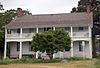 |
January 19, 1995 (#94001643) |
Bayside Rd. 38°08′54″N 75°17′15″W / 38.148333°N 75.2875°W | Public Landing | |
| 20 | Mar-Va Theater |  |
March 21, 1996 (#96000301) |
103 Market St. 38°04′33″N 75°34′09″W / 38.075833°N 75.569167°W | Pocomoke City | |
| 21 | James Martin House | 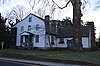 |
August 22, 1996 (#96000922) |
207 Ironshire St. 38°10′16″N 75°23′39″W / 38.171111°N 75.394167°W | Snow Hill | |
| 22 | Merry Sherwood |  |
September 20, 1991 (#91001420) |
8909 Worcester Highway 38°18′20″N 75°13′23″W / 38.305556°N 75.223056°W | Berlin | |
| 23 | Nassawango Iron Furnace Site |  |
October 31, 1975 (#75000935) |
On Old Furnace Road, northwest of Snow Hill off Maryland Route 12 38°12′15″N 75°28′08″W / 38.204167°N 75.468889°W | Snow Hill | |
| 24 | Nun's Green | September 20, 1979 (#79003263) |
South of Snow Hill on Cherrix Rd. 38°07′49″N 75°22′57″W / 38.130278°N 75.3825°W | Snow Hill | ||
| 25 | Pocomoke City Historic District |  |
December 23, 2004 (#04001383) |
Market, Cedar, 2nd, Clarke, and Bridge Sts. and Linden Ave. 38°04′24″N 75°33′57″W / 38.073333°N 75.565833°W | Pocomoke City | |
| 26 | George Washington Purnell House |  |
August 22, 1996 (#96000920) |
201 E. Market St. 38°10′40″N 75°23′33″W / 38.177778°N 75.3925°W | Snow Hill | |
| 27 | Queponco Railway Station |  |
January 19, 1996 (#95001546) |
2378 Patey Woods Rd. 38°15′05″N 75°17′34″W / 38.251389°N 75.292778°W | Newark | |
| 28 | Sandy Point Site | |
April 28, 1975 (#75000932) |
Address Restricted | Ocean City | |
| 29 | Simpson's Grove | 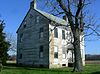 |
August 30, 1996 (#96000949) |
Eastern side of Downs Rd., approximately 2 miles southwest of the junction of U.S. Routes 50 and 113 38°16′42″N 75°14′53″W / 38.278333°N 75.248056°W | Ironshire | |
| 30 | Gov. John Walter Smith House |  |
September 15, 1994 (#94001146) |
104 S. Church St. 38°10′23″N 75°23′41″W / 38.173056°N 75.394722°W | Snow Hill | |
| 31 | St. Martins Church |  |
April 13, 1977 (#77000707) |
1 mile south of Showell at the junction of U.S. Route 113 and Maryland Route 589 38°23′34″N 75°12′18″W / 38.392778°N 75.205°W | Showell | |
| 32 | St. Paul's by-the-sea Protestant Episcopal Church | 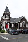 |
October 22, 2008 (#08001013) |
302 N. Baltimore St. 38°20′05″N 75°05′05″W / 38.334722°N 75.084722°W | Ocean City | |
| 33 | Williams Grove | August 22, 1996 (#96000919) |
11842 Porfin Dr. 38°15′40″N 75°09′16″W / 38.261111°N 75.154444°W | Berlin | ||
| 34 | Young-Sartorius House | 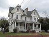 |
August 30, 1996 (#96000948) |
405 Market St. 38°04′25″N 75°33′57″W / 38.073611°N 75.565833°W | Pocomoke City |
See also edit
Wikimedia Commons has media related to National Register of Historic Places in Worcester County, Maryland.
References edit
- ^ The latitude and longitude information provided in this table was derived originally from the National Register Information System, which has been found to be fairly accurate for about 99% of listings. Some locations in this table may have been corrected to current GPS standards.
- ^ National Park Service, United States Department of the Interior, "National Register of Historic Places: Weekly List Actions", retrieved April 12, 2024.
- ^ Numbers represent an alphabetical ordering by significant words. Various colorings, defined here, differentiate National Historic Landmarks and historic districts from other NRHP buildings, structures, sites or objects.
- ^ "National Register Information System". National Register of Historic Places. National Park Service. April 24, 2008.
- ^ The eight-digit number below each date is the number assigned to each location in the National Register Information System database, which can be viewed by clicking the number.