


Summary
Novaya Zemlya (/ˌnoʊvəjə ˈzɛmliə/, also UK: /ˌnɒv-, -aɪ.ə -/, US: /- zɛmˈl(j)ɑː/;[1][2] Russian: Но́вая Земля́, IPA: [ˈnovəjə zʲɪmˈlʲa], lit. 'New Land') is an archipelago in northern Russia. It is situated in the Arctic Ocean, in the extreme northeast of Europe, with Cape Flissingsky, on the northern island, considered the easternmost point of Europe. To Novaya Zemlya's west lies the Barents Sea and to the east is the Kara Sea.
Новая Земля (Russian) | |
|---|---|
 Map of Novaya Zemlya | |
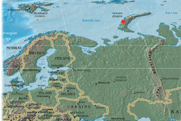 Location of Novaya Zemlya, including the site of the Tsar Bomba detonation | |
| Geography | |
| Location | Arctic Ocean |
| Coordinates | 74°N 56°E / 74°N 56°E |
| Major islands | 2 |
| Area | 83,000 km2 (32,000 sq mi) |
| Highest elevation | 1,547 m (5075 ft) |
| Highest point | Gora Kruzenshterna |
| Administration | |
Russia | |
| Federal subject | Arkhangelsk Oblast |
| Largest settlement | Belushya Guba (pop. 1,972) |
| Demographics | |
| Population | 3,576 (2021) |
| Pop. density | 0.04/km2 (0.1/sq mi) |
| Additional information | |
Flag Seal | |

Novaya Zemlya consists of two main islands, the northern Severny Island and the southern Yuzhny Island, which are separated by the Matochkin Strait. Administratively, it is incorporated as Novaya Zemlya District, one of the twenty-one in Arkhangelsk Oblast, Russia.[3] Municipally, it is incorporated as Novaya Zemlya Urban Okrug.[4]
Novaya Zemlya was a sensitive military area during the Cold War, and parts of it are still used for airfields today. The Soviet Air Force maintained a presence at Rogachevo on the southern part of the southern island, on the westernmost peninsula (71°37′04″N 52°28′44″E / 71.61787°N 52.47884°E). It was used primarily for interceptor aircraft operations, but also provided logistical support for the nearby nuclear test area. Novaya Zemlya was one of the two major nuclear test sites managed by the USSR; it was used for air drops and underground testing of the largest of Soviet nuclear bombs, in particular the October 30, 1961, air burst explosion of Tsar Bomba, the largest, most powerful nuclear weapon ever detonated.
History edit
The Russian people knew of Novaya Zemlya from the 11th century, when hunters from Novgorod visited the area.[5] For Western Europeans, the search for the Northern Sea Route in the 16th century led to its exploration.[5] The first visit from a Western European was by Hugh Willoughby in 1553.[5] Dutch explorer Willem Barentsz reached the west coast of Novaya Zemlya in 1594, and in a subsequent expedition of 1596, he rounded the northern cape and wintered on the northeastern coast.[6] (Barentsz died during the expedition, and may have been buried on Severny Island.[7]) During a later voyage by Fyodor Litke in 1821–1824, the western coast was mapped.[5] Henry Hudson was another explorer who passed through Novaya Zemlya while searching for the Northeast Passage.[8]
The islands were systematically surveyed by Pyotr Pakhtusov and Avgust Tsivolko during the early 1830s. The first permanent settlement was established in 1870 at Malye Karmakuly, which served as capital of Novaya Zemlya until 1924. Later, the administrative center was transferred to Belushya Guba,[9][10] in 1935 to Lagernoe,[9] but then returned to Belushya Guba.
-
 Willem Barentsz' ship among the Arctic ice.
 -
 1599–1601 map of Novaya Zemlya.
 -
 Map of Novaya Zemlya from 1720.


World War II edit
In the months following Hitler's June 1941 invasion of the Soviet Union, the United States and Great Britain organized convoys of merchant ships under naval escort to deliver Lend-Lease supplies to northern Soviet seaports. The Allied convoys up to PQ 12 arrived unscathed but German aircraft, ships and U-boats were sent to northern Norway and Finland to oppose the convoys.[11]
Convoy PQ 17 edit
Convoy PQ 17 consisted of thirty-six merchant ships containing 297 aircraft, 596 tanks, 4,286 other vehicles and more than 150,000 long tons (152,407 t) of other cargo, six destroyer escorts, fifteen additional armed ships (among which were two Free-French corvettes) and three small rescue craft. The convoy departed Iceland on June 27, 1942, one ship running aground and dropping out of the convoy.[12] The convoy was able to sail north of Bear Island but encountered ice floes on June 30; a ship was damaged too badly to carry on and broke radio silence. On the following morning, the convoy was detected by German U-boats and German reconnaissance aircraft and torpedo bomber attacks began on July 2.[13]
On the night of July 2/3, the German battleship Tirpitz and the heavy cruiser Admiral Hipper, sortied from Trondheim with four destroyers and two smaller vessels. The pocket battleships Admiral Scheer and Lützow and six destroyers sailed from Narvik, but Lützow and three destroyers ran aground.[14] The British Admiralty responded on July 4 by diverting the escort vessels to the west to rendezvous with the Home Fleet and ordered the merchant vessels to scatter. Seeking safety in the Matochkin Strait, several ships headed toward Novaya Zemlya.
Operation Wunderland edit
In August 1942, the German Navy commenced Operation Wunderland, to enter the Kara Sea and sink as many Soviet ships as possible. Admiral Scheer and other warships rounded Cape Desire, entered the Kara Sea and attacked a shore station on Dikson Island, badly damaging the Soviet ships Dezhnev and Revolutionist.[citation needed] Later that year, Karlo Štajner made the acquaintance of a new prisoner, a Captain Menshikov, who told him that:
"In August 1942, another…transport arrived in Novaya Zemlya. The escort ships turned around and went back. Just a few hours later, the watchman in the tower announced that a ship was in sight. Everyone assumed it was one of the Allied warships and didn't give the matter any importance. Shortly after, the watchman announced that the ship was nearing the bay. I went outside…to see for myself. As soon as I had climbed the tower, I realized to my horror that this was a German warship. I gave the alarm, but it was too late… the German cruiser was coming closer. One of the Allied freighters — the first ship we managed to get moving — steered its way out of the bay. That's all the Germans were waiting for. At the moment when the ship reached the narrowest part of the bay, the German guns sent off their first salvo — a direct hit… our coastal batteries opened fire… but the guns didn't reach far enough… [they] came closer and destroyed all the ships in the bay, as well as a large part of the harbor [and] left a hundred dead and wounded."
Whether the attack on Menshikov's battery occurred on Dikson Island or on Novaya Zemlya, Stajner's account illuminated the fate of a Soviet officer imprisoned by his countrymen for the "crime" of suffering defeat at the hands of the enemy. Not surprisingly, Menshikov's arrest was never announced in the Soviet press.
1943 operations edit
In August 1943, a German U-boat sank the Soviet research ship Akademic Shokalskiy near Mys Sporyy Navolok but the Soviet Navy, now on the offensive, destroyed the German submarine U-639 near Mys Zhelaniya.
In 1943, Novaya Zemlya briefly served as a secret seaplane base for Nazi Germany's Kriegsmarine, to provide German surveillance of Allied shipping en route to Siberia. The seaplane base was established by U-255 and U-711, which were operating along the northern coast of Soviet Russia as part of 13th U-boat Flotilla. Seaplane sorties were flown in August and September 1943.[15]
Nuclear testing edit
| Novaya Zemlya | |
|---|---|
 Novaya Zemlya Test Site boundaries and facilities | |
| Type | Nuclear test site |
| Area | land: 55,200 km2 (21,300 sq mi) water: 36,000 km2 (14,000 sq mi) |
| Site information | |
| Operator | Russian Federation (formerly Soviet Union) |
| Status | Active |
| Site history | |
| In use | 1955–present |
| Test information | |
| Subcritical tests | not known |
| Nuclear tests | 224 |
In July 1954, Novaya Zemlya was designated as the nuclear weapons testing venue, construction of which began in October[16] and existed during much of the Cold War. "Zone A", Chyornaya Guba (70°42′N 54°36′E / 70.7°N 54.6°E), was used in 1955–1962 and 1972–1975.[16] "Zone B", Matochkin Shar (73°24′N 54°54′E / 73.4°N 54.9°E), was used for underground tests in 1964–1990.[16] "Zone C", Sukhoy Nos (73°42′N 54°00′E / 73.7°N 54.0°E), was used in 1958–1961 and was the site of the 1961 test of the Tsar Bomba, the most powerful nuclear weapon ever detonated.[16]
Other tests occurred elsewhere throughout the islands, with an official testing range covering over half of the landmass. In September 1961, two propelled thermonuclear warheads were launched from Vorkuta Sovetsky and Salekhard to target areas on Novaya Zemlya. The launch rocket was subsequently deployed to Cuba.[17]
1963 saw the implementation of the Limited Test Ban Treaty which banned most atmospheric nuclear tests.[18] The largest underground test in Novaya Zemlya took place on September 12, 1973, involving four nuclear devices of 4.2 megatons total yield. Although far smaller in blast power than the Tsar Bomba and other atmospheric tests, the confinement of the blasts underground led to pressures rivaling natural earthquakes. In the case of the September 12, 1973 test, a seismic magnitude of 6.97 on the Richter Scale was reached, setting off an 80 million ton avalanche that blocked two glacial streams and created a lake 2 kilometres (1.2 mi) in length.[18]
Over its history as a nuclear test site, Novaya Zemlya hosted 224 nuclear detonations with a total explosive energy equivalent to 265 megatons of TNT.[16] For comparison, all explosives used in World War II, including the detonations of two US nuclear bombs, amounted to only two megatons.[18]
In 1988–1989, glasnost helped make the Novaya Zemlya testing activities public knowledge,[16] and in 1990 Greenpeace activists staged a protest at the site.[19] The last nuclear test explosion was in 1990 (also the last for the entire Soviet Union and Russia). The Ministry for Atomic Energy has performed a series of subcritical underwater nuclear experiments near Matochkin Shar each autumn since 1998.[20] These tests reportedly involve up to 100 grams (3.5 oz) of weapons-grade plutonium.[21]
In October 2012, it was reported that Russia would resume subcritical nuclear testing at "Zone B". In Spring 2013, construction of what would become a new tunnel and four buildings[22] was initiated near the Severny settlement, 3 kilometres (1.9 mi) west-northwest to the Mount Lazarev.[23][24]
In 2023, CNN reported that commercial satellite imagery showed new tunneling activity and surface construction at Novaya Zemlya test sites (including published imagery at 73°23′06″N 54°44′24″E / 73.385°N 54.740°E) that indicated possible preparation for resumption of nuclear testing.[25]
Population edit

| Year | Pop. | ±% |
|---|---|---|
| 1911 | 108 | — |
| 1936 | 390 | +261.1% |
| 1955 | 536 | +37.4% |
| 2002 | 2,716 | +406.7% |
| 2010 | 2,429 | −10.6% |
| 2021 | 2,302 | −5.2% |
| Source: Census data and estimates | ||
A 17th century traveller to the North, ship surgeon Pierre Martin de La Martinière[26] gave a description of the indigenous population of the archipelago, whom he called Zembliens, from Nova Zembla or Nouvelle Zemble for "Novaya Zemlya".[27][28] The noted that they worshipped the Sun and wooden idols.[29]
In 1870s several Nenets families were resettled from elsewhere as part of the colonization of the territory by Russian Empire, who established a settlement of Malye Karmakuly (Малые Кармакулы).[30]
The indigenous population (from 1872[31][9] to the 1950s) consisted of about 50–300 Nenets[32] who subsisted mainly on fishing, trapping, reindeer herding, polar bear hunting and seal hunting.[33][34] Natural resources include copper, lead, and zinc.[33]
All civilian population was transferred to the mainland in 1957 before nuclear testing began.[34][35][36][37]
The population of Novaya Zemlya as of the 2010 Census was about 2,429, of whom 1,972 resided in Belushya Guba,[38] an urban settlement that is the administrative center of Novaya Zemlya District. 457 more persons resided in the second largest settlement of Rogachevo, Rogachevo. The population are mainly military and construction workers.
Geography and geology edit

Novaya Zemlya is an extension of the northern part of the Ural Mountains,[39] and the interior is mountainous throughout.[5] It is separated from the mainland by the Kara Strait.[5] Novaya Zemlya consists of two major islands, separated by the narrow Matochkin Strait, as well as a number of smaller islands. The two main islands are:
- Severny (Northern), which has a large ice cap, the Severny Island ice cap, as well as many active glaciers. It has an area of 48,904 square kilometres (18,882 sq mi).
- Yuzhny (Southern), which is largely unglaciated and has a tundra landscape.[33] It has an area of 33,275 square kilometres (12,800 sq mi).
The coast of Novaya Zemlya is very indented, and it is the area with the largest number of fjords in the Russian Federation. Novaya Zemlya separates the Barents Sea from the Kara Sea. The total area is about 83,000 square kilometers (32,000 sq mi). The highest mountain is located on the Northern island and is 1,547 meters (5,075 ft) high.[40]
Compared to other regions that were under large ice sheets during the last glacial period, Novaya Zemlya shows relatively little isostatic rebound. Possibly this is indebted to a counter-effect created by the growth of glaciers during the last few thousand years.[41]
Geology edit
The geology of Novaya Zemlya is dominated by a large anticlinal structure that forms an extension of the Ural Mountains. The geology is primarily formed of Paleozoic sedimentary rocks, including both carbonate and siliciclastic rocks spanning the Cambrian to Permian, ranging from deep marine turbidites and flysch to shallow marine and terrestrial sandstones and reef limestones. Small areas of late Neoproterozoic (~600 mya) granite and associated metasedimentary rocks are also exposed.[42]
-
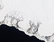 Natural-color satellite image of the Nordenskiöld Glacier group. East coast, Severny
 -
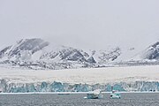
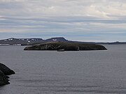 Wide shot of Novaya Zemlya
 -
 Barents Bay (Willem Barents' gravesite; 76°27′N 68°42′E / 76.450°N 68.700°E)
 -
 Inostrantsev Glacier terminus (76°28′N 66°5′E / 76.467°N 66.083°E)
 -
 Cape Zhelaniya (Northernmost cape of Severny; 76°57′N 68°35′E / 76.950°N 68.583°E)


Environment edit
The ecology of Novaya Zemlya is influenced by its severe climate, but the region nevertheless supports a diversity of biota. One of the most notable species present is the polar bear, whose population in the Barents Sea region is genetically distinct from other polar bear subpopulations.[43]
Climate edit
Novaya Zemlya has a maritime-influenced variety of a tundra climate (Köppen ET). Due to some effect from the Gulf Stream and its offshore position, winters are a lot less severe than in inland areas on a lot lower latitudes in Siberia, but instead last up to eight months a year. The milder waters to its west delays the onset of sea ice and causes vast seasonal lag in shoulder seasons. Due to latitudinal differences, the temperatures and daylight varies quite a bit throughout the archipelago, with the Malye Karmakuly station being located in the southern part. Novaya Zemlya is cloudy in general, but snowfall and rainfall is relatively scarce for being a maritime location. Even so, glaciers dominate the northern interior and there is strong snow accumulation each winter due to the length of the season.
| Climate data for Malye Karmakuly, Novaya Zemlya | |||||||||||||
|---|---|---|---|---|---|---|---|---|---|---|---|---|---|
| Month | Jan | Feb | Mar | Apr | May | Jun | Jul | Aug | Sep | Oct | Nov | Dec | Year |
| Record high °C (°F) | 2.6 (36.7) |
1.7 (35.1) |
2.0 (35.6) |
7.8 (46.0) |
17.6 (63.7) |
22.2 (72.0) |
28.3 (82.9) |
23.8 (74.8) |
16.5 (61.7) |
9.7 (49.5) |
4.5 (40.1) |
2.5 (36.5) |
28.3 (82.9) |
| Mean daily maximum °C (°F) | −10.9 (12.4) |
−11.5 (11.3) |
−9.1 (15.6) |
−6.7 (19.9) |
−1.4 (29.5) |
4.9 (40.8) |
10.3 (50.5) |
9.0 (48.2) |
5.5 (41.9) |
−0.1 (31.8) |
−4.8 (23.4) |
−8.1 (17.4) |
−1.9 (28.6) |
| Daily mean °C (°F) | −14.1 (6.6) |
−14.7 (5.5) |
−12.2 (10.0) |
−9.9 (14.2) |
−3.7 (25.3) |
2.5 (36.5) |
7.3 (45.1) |
6.8 (44.2) |
3.7 (38.7) |
−1.8 (28.8) |
−7.1 (19.2) |
−11.1 (12.0) |
−4.5 (23.9) |
| Mean daily minimum °C (°F) | −17.3 (0.9) |
−17.9 (−0.2) |
−15.2 (4.6) |
−13.0 (8.6) |
−5.8 (21.6) |
0.7 (33.3) |
5.1 (41.2) |
4.9 (40.8) |
2.1 (35.8) |
−4.0 (24.8) |
−9.9 (14.2) |
−14.1 (6.6) |
−7.0 (19.4) |
| Record low °C (°F) | −36.0 (−32.8) |
−37.4 (−35.3) |
−40.0 (−40.0) |
−29.9 (−21.8) |
−25.9 (−14.6) |
−9.6 (14.7) |
−2.8 (27.0) |
−1.7 (28.9) |
−9.9 (14.2) |
−21.1 (−6.0) |
−29.1 (−20.4) |
−36.2 (−33.2) |
−40.0 (−40.0) |
| Average precipitation mm (inches) | 30 (1.2) |
26 (1.0) |
24 (0.9) |
20 (0.8) |
15 (0.6) |
23 (0.9) |
36 (1.4) |
31 (1.2) |
39 (1.5) |
35 (1.4) |
24 (0.9) |
33 (1.3) |
336 (13.2) |
| Average rainy days | 1 | 1 | 1 | 1 | 3 | 10 | 15 | 17 | 19 | 9 | 3 | 2 | 82 |
| Average snowy days | 18 | 18 | 19 | 17 | 17 | 10 | 1 | 1 | 6 | 17 | 19 | 20 | 163 |
| Average relative humidity (%) | 78 | 77 | 77 | 76 | 78 | 81 | 83 | 83 | 85 | 82 | 79 | 78 | 80 |
| Mean monthly sunshine hours | 0 | 25 | 107 | 215 | 189 | 173 | 229 | 143 | 73 | 40 | 3 | 0 | 1,197 |
| Source 1: Pogoda.ru.net[44] | |||||||||||||
| Source 2: NOAA (sun 1961–1990)[45] | |||||||||||||
Polar bears enter human-inhabited areas more frequently than previously, which has been attributed to climate change. Global warming reduces sea ice, forcing the bears to come inland to find food. In February 2019, a mass migration occurred in the northeastern portion of Novaya Zemlya. Dozens of polar bears were seen entering homes, public buildings, and inhabited areas, so Arkhangelsk region authorities declared a state of emergency on Saturday, February 16, 2019.[46][47]
In popular culture edit
- In Clive Cussler's 1976 novel Raise the Titanic!, Nova Zemlya is the location of a rare mineral, byzanium, mined secretly by Americans in 1911. A map of the island is provided.
- In Pale Fire (1962), Kinbote's home country is named Zembla, and references to Novaya Zemlya are made throughout the novel.[48]
- In 2011, a Dutch feature film, Nova Zembla, depicted the last journey of Willem Barentsz.
See also edit
References edit
Notes edit
- ^ Wells, John C. (2008). Longman Pronunciation Dictionary (3rd ed.). Longman. ISBN 978-1-4058-8118-0.
- ^ Upton, Clive; Kretzschmar, William A. Jr. (2017). The Routledge Dictionary of Pronunciation for Current English (2nd ed.). Routledge. p. 910. ISBN 978-1-138-12566-7.
- ^ Law #65-5-OZ
- ^ Law #258-vneoch.-OZ
- ^ a b c d e f Chisholm, Hugh, ed. (1911). . Encyclopædia Britannica. Vol. 19 (11th ed.). Cambridge University Press. pp. 832–833.
- ^ Whitfield, Peter (1998). New Found Lands: Maps in the History of Exploration. UK: Routledge. ISBN 0-415-92026-4.
- ^ Zeeberg, Jaapjan J.; et al. (2002). "Search for Barents: Evaluation of Possible Burial Sites on North Novaya Zemlya, Russia". Arctic. 55 (4): 329–338. doi:10.14430/arctic716. JSTOR 40512490.
- ^ Henry Hudson in: Microsoft Encarta Online Encyclopedia 2006. Archived from the original on May 24, 2008. Retrieved October 14, 2006.
- ^ a b c "Новая земля в 1917–1941 гг". Belushka.virtbox.ru. Retrieved September 27, 2012.
- ^ "Health, science and education, history and trade among others – news review from the Arkhangelsk region". Barents.fi. August 3, 2005. Retrieved September 27, 2012.
- ^ Woodman 2004, pp. 33–83.
- ^ Woodman 2004, pp. 197, 199.
- ^ Woodman 2004, p. 201.
- ^ Woodman 2004, pp. 203–204.
- ^ Warship International No. 3, 1987, p. 318.
- ^ a b c d e f Khalturin, Vitaly I.; Rautian, Tatyana G.; Richards, Paul G.; Leith, William S. (2005). "A Review of Nuclear Testing by the Soviet Union at Novaya Zemlya, 1955–1990" (PDF). Science and Global Security. 13 (1): 1–42. Bibcode:2005S&GS...13....1K. doi:10.1080/08929880590961862. S2CID 122069080. Archived from the original (PDF) on August 14, 2016. Retrieved October 14, 2006.
- ^ "Testing the Kosmos 2 rocket". Astronautix.com. Archived from the original on June 18, 2012. Retrieved September 27, 2012.
- ^ a b c Pratt, Sara (November 28, 2005). "Frozen in Time: A Cold War Relic Gives up its Secrets". Lamont–Doherty Earth Observatory, Columbia University. Archived from the original on September 16, 2020. Retrieved October 14, 2006.
- ^ "The early history of Greenpeace Russia". Greenpeace Russia. Archived from the original on May 2, 2007. Retrieved October 14, 2006.
- ^ Jasinski, Michael; Chuen, Cristina; Ferguson, Charles D. (October 2002). "Russia: Of truth and testing". Bulletin of the Atomic Scientists. 58 (5): 60–65. Bibcode:2002BuAtS..58e..60J. doi:10.1080/00963402.2002.11460608. S2CID 218769187. Retrieved September 22, 2009.
- ^ "Russia: Central Test Site, Novaya Zemlya". Nuclear Threat Initiative. July 30, 2003. Retrieved October 14, 2006.
- ^ 73°22′03″N 54°48′00″E / 73.367363°N 54.799984°E
- ^ "Russia May Resume Subcritical Atomic Testing: Sources". Nuclear Threat Initiative. Retrieved January 22, 2020.
- ^ "The Underground Nuclear Test Site at Novaya Zemlya". Ceros. Retrieved January 22, 2020.
- ^ Eric Cheung; Brad Lendon; Ivan Watson (September 23, 2023). "Exclusive: Satellite images show increased activity at nuclear test sites in Russia, China and US". CNN.
- ^ "Освоение Новой Земли" (tr. "Development of Novaya Zemlya") belushka.ru
- ^ LA MARTINIERE, Pierre-Martin de, Le nouveau voyage du nort, dans lequel on voit les moeurs, la manière de vivre, et les superstitions des Norweghiens, des Lapons, des Kiloppes, des Borandiens, des Syberiens, des Moscovites, des Samojèdes, des Zembliens et des Islandois (readable in Google Books)
- ^ CHAP. XXXIX. The taking of another Zemblane and his Wife, their Habits, Arms, and manner of living, from the English translation of Le nouveau voyage du nort
- ^ Le nouveau voyage du nort, Chapter LIII, p. 273
- ^ Новая земля - история заселения arhangelsk.allnw.ru
- ^ "Новая земля – история заселения" [Novaya Zemlya - history of settlement]. Belushka.virtbox.ru. Retrieved September 27, 2012.
- ^ "Microsoft Word - North Test Site _FINAL_.doc" (PDF). Retrieved September 27, 2012.
- ^ a b c Novaya Zemlya in: "The Columbia Encyclopedia, 6th ed". Retrieved October 14, 2006.
- ^ a b Ядерные испытания СССР. Том 1. Глава 2 www.npc.sarov.ru Archived April 14, 2010, at the Wayback Machine, p. 58.
- ^ "Nenets" www.npolar.no Archived August 7, 2009, at the Wayback Machine, Arctic Network for the Support of the Indigenous Peoples of the Russian Arctic
- ^ "The Nenets", www.eki.ee The Red Book of the Peoples of the Russian Empire
- ^ "Nuclear Free Seas" Archived January 10, 2009, at the Wayback Machine, Greenpeace
- ^ Russian Federal State Statistics Service (2011). Всероссийская перепись населения 2010 года. Том 1 [2010 All-Russian Population Census, vol. 1]. Всероссийская перепись населения 2010 года [2010 All-Russia Population Census] (in Russian). Federal State Statistics Service.
- ^ "Novaya Zemlya, Northern Russia". NASA. Archived from the original on October 11, 2006. Retrieved October 14, 2006.
- ^ Russian military mapping. The highest point is located at 75°10′N 57°50′E / 75.167°N 57.833°E
- ^ Feldskaar, Willy; Amantov, Aleksey (August 21, 2017). "Liten landheving på Novaya Zemlya?" [Small land uplift on Novaya Zemlya?]. geoforskning.no (in Norwegian). Retrieved April 29, 2016.
- ^ Lorenz, Henning; Gee, David G.; Korago, Evgeny; Kovaleva, Galina; McClelland, William C.; Gilotti, Jane A.; Frei, Dirk (December 2013). "Detrital zircon geochronology of Palaeozoic Novaya Zemlya - a key to understanding the basement of the Barents Shelf". Terra Nova. 25 (6): 496–503. Bibcode:2013TeNov..25..496L. doi:10.1111/ter.12064. S2CID 128745495.
- ^ C. Michael Hogan (2008) Polar Bear: Ursus maritimus, Globaltwitcher.com, ed. Nicklas Stromberg Archived December 24, 2008, at the Wayback Machine
- ^ "Weather and Climate-The Climate of Malye Karmakuly" (in Russian). Weather and Climate (Погода и климат). Retrieved February 27, 2016.
- ^ "Malye Karmakuly Climate Normals 1961–1990". National Oceanic and Atmospheric Administration. Retrieved February 27, 2016.
- ^ Abellan Matamoros, Cristina (February 13, 2019). "Watch: Polar bear in Russian archipelago peeks inside a house". euronews.com. Euronews. Retrieved February 14, 2019.
- ^ Stambaugh, Alex (February 12, 2019). "Polar bear invasion: Parents scared to send children to school in remote Russian archipelago". edition.cnn.com. CNN. Retrieved February 15, 2019.
- ^ Pitzer, Andrea (March 1, 2013). "The mysteries of Zembla". The Secret History of Vladimir Nabokov. Retrieved May 26, 2021.
Sources edit
- Архангельское областное Собрание депутатов. Областной закон №65-5-ОЗ от 23 сентября 2009 г. «Об административно-территориальном устройстве Архангельской области», в ред. Областного закона №232-13-ОЗ от 16 декабря 2014 г. «О внесении изменений в отдельные Областные Законы в сфере осуществления местного самоуправления и взаимодействия с некоммерческими организациями». Вступил в силу через десять дней со дня официального опубликования. Опубликован: "Волна", №43, 6 октября 2009 г. (Arkhangelsk Oblast Council of Deputies. Oblast Law #65-5-OZ of September 23, 2009 On the Administrative-Territorial Structure of Arkhangelsk Oblast, as amended by the Oblast Law #232-13-OZ of December 16, 2014 On Amending Various Oblast Laws Dealing with the Process of Municipal Self-Government and Relations with Non-Profit Organizations. Effective as of the day which is ten days after the official publication.).
- Архангельское областное Собрание депутатов. Областной закон №258-внеоч.-ОЗ от 23 сентября 2004 г. «О статусе и границах территорий муниципальных образований в Архангельской области», в ред. Областного закона №224-13-ОЗ от 16 декабря 2014 г. «Об упразднении отдельных населённых пунктов Соловецкого района Архангельской области и о внесении изменения в статью 46 Областного закона "О статусе и границах территорий муниципальных образований в Архангельской области"». Вступил в силу со дня официального опубликования. Опубликован: "Волна", №38, 8 октября 2004 г. (Arkhangelsk Oblast Council of Deputies. Oblast Law #258-vneoch.-OZ of September 23, 2004 On the Status and Borders of the Territories of the Municipal Formations in Arkhangelsk Oblast, as amended by the Oblast Law #224-13-OZ of December 16, 2014 On Abolishing Several Inhabited Localities in Solovetsky District of Arkhangelsk Oblast and on Amending Article 46 of the Oblast Law "On the Status and Borders of the Territories of the Municipal Formations in Arkhangelsk Oblast". Effective as of the day of the official publication.).
- Roskill, S. W. (1962) [1956]. The Period of Balance. History of the Second World War: The War at Sea 1939–1945. Vol. II (3rd impr. ed.). London: HMSO. OCLC 174453986. Retrieved February 11, 2019.
- Woodman, Richard (2004) [1994]. Arctic Convoys 1941–1945. London: John Murray. ISBN 978-0-7195-5752-1.
Further reading edit
- Serebryanny, Leonid (June 1997). "The Colonization and Peoples of Novaya Zemlya then and now". Nationalities Papers. 25 (2): 301–309. doi:10.1080/00905999708408505. S2CID 129588062.
External links edit
- . . 1914.
- Novaya Zemlya information portal
- Environment, climate change, and history of exploration (Barents' wintering).
- Rozenberg Publishers – Climate and glacial history of the Novaya Zemlya Archipelago, Russian Arctic Archived July 19, 2004, at the Wayback Machine
- Nuclear tests in Novaya Zemlya, International Atomic Energy Agency Department of Nuclear Safety and Security.
- Испытание чистой водородной бомбы мощностью 50 млн тонн, declassified Rosatom historical video of the RDS-220, or Tsar Bomba, 50 megatonne hydrogen bomb test on 30 October 1961. at 8:55–9:30. 20 August 2020.