


Summary
Omsukchansky District (Russian: Омсукча́нский райо́н) is an administrative[1] district (raion), one of the eight in Magadan Oblast, Russia. As a municipal division, it is incorporated as Omsukchansky Urban Okrug.[6] It is located in the eastern central part of the oblast. The area of the district is 60,400 square kilometers (23,300 sq mi).[2] Its administrative center is the urban locality (an urban-type settlement) of Omsukchan.[1] As of the 2010 Census, the total population of the district was 5,531, with the population of Omsukchan accounting for 75.2% of that number.[3]
Omsukchansky District
Омсукчанский район | |
|---|---|
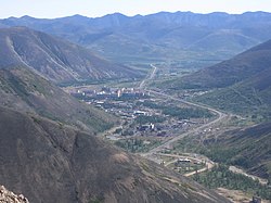 View of the urban-type settlement of Dukat in Omsukchansky District | |
 Flag  Coat of arms | |
 Location of Omsukchansky District in Magadan Oblast | |
| Coordinates: 63°00′N 156°20′E / 63.000°N 156.333°E | |
| Country | Russia |
| Federal subject | Magadan Oblast[1] |
| Established | July 16, 1954[2] |
| Administrative center | Omsukchan[1] |
| Area | |
| • Total | 60,400 km2 (23,300 sq mi) |
| Population | |
| • Total | 5,531 |
| • Estimate (2018)[4] | 5,053 (−8.6%) |
| • Density | 0.092/km2 (0.24/sq mi) |
| • Urban | 99.7% |
| • Rural | 0.3% |
| Administrative structure | |
| • Inhabited localities[1] | 3 Urban-type settlements[5], 2 rural localities |
| Municipal structure | |
| • Municipally incorporated as | Omsukchansky Urban Okrug[6] |
| Time zone | UTC+11 (MSK+8 |
| OKTMO ID | 44704000 |
| Website | http://omsukchan-adm.ru |

| Year | Pop. | ±% |
|---|---|---|
| 1959 | 4,927 | — |
| 1970 | 7,446 | +51.1% |
| 1979 | 14,886 | +99.9% |
| 1989 | 19,419 | +30.5% |
| 2002 | 6,209 | −68.0% |
| 2010 | 5,531 | −10.9% |
| 2021 | 4,543 | −17.9% |
| Source: Census data | ||
History edit
The territory of modern Omsukchansky District was originally a part of Severo-Evensky District.[2] The split was formalized on July 16, 1954, which is considered the date of Omsukchansky District's foundation.[2]
Geography edit
The Omsukchan Range, highest ridge of the Kolyma Mountains, rises in the district to the northwest of Omsukchan town. The Korkodon river flows across the district in its upper course.[8]
Administrative and municipal status edit
Within the framework of administrative divisions, Omsukchansky District is one of the eight in the oblast.[1] The urban locality (an urban-type settlement) of Omsukchan serves as its administrative center.[1]
As a municipal division, the district has been incorporated as Omsukchansky Urban Okrug since January 1, 2015.[6] Prior to that date, the district was incorporated as Omsukchansky Municipal District, which was subdivided into two urban settlements.
Settlements edit
| Name | Type | Pop. (2017) | Coord |
|---|---|---|---|
| Omsukchan (Омсукчан) |
Urban-type, seat
|
3,763
|
62°30′40.6″N 155°47′01.4″E / 62.511278°N 155.783722°E
|
| Dukat (Дукат) |
1,315
|
62°34′28.4″N 155°23′08.0″E / 62.574556°N 155.385556°E
| |
| Galimy (Галимый) |
0
|
62°21′14.2″N 155°57′50.0″E / 62.353944°N 155.963889°E
| |
| Merenga (Меренга) |
0
|
61°53′27.2″N 156°08′12.0″E / 61.890889°N 156.136667°E
| |
| Verkhny Balygychan (Верхний Балыгычан) |
0
|
62°06′55.4″N 154°40′39.6″E / 62.115389°N 154.677667°E
| |
| Industrialny (Индустриальный) |
0
|
62°33′11.4″N 155°41′53.5″E / 62.553167°N 155.698194°E
| |
| Kupka (Купка) |
0
|
62°04′02.1″N 153°30′03.2″E / 62.067250°N 153.500889°E
| |
| Trud (Труд) |
0
|
62°05′03.1″N 155°42′13.0″E / 62.084194°N 155.703611°E
|
See also edit
References edit
Notes edit
- ^ a b c d e f g Law #1292-OZ
- ^ a b c d e "About the Municipal Formation" (in Russian). Omsukchansky District. Retrieved December 18, 2017.
- ^ a b Russian Federal State Statistics Service (2011). Всероссийская перепись населения 2010 года. Том 1 [2010 All-Russian Population Census, vol. 1]. Всероссийская перепись населения 2010 года [2010 All-Russia Population Census] (in Russian). Federal State Statistics Service.
- ^ "26. Численность постоянного населения Российской Федерации по муниципальным образованиям на 1 января 2018 года". Federal State Statistics Service. Retrieved January 23, 2019.
- ^ The count of urban-type settlements may include the work settlements, the resort settlements, the suburban (dacha) settlements, as well as urban-type settlements proper.
- ^ a b c Law #1808-OZ
- ^ "Об исчислении времени". Официальный интернет-портал правовой информации (in Russian). June 3, 2011. Retrieved January 19, 2019.
- ^ 1,000,000 scale Operational Navigation Chart; Sheet D-8
Sources edit
- Магаданская областная Дума. Закон №1292-ОЗ от 9 июня 2010 г. «Об административно-территориальном устройстве Магаданской области», в ред. Закона №1756-ОЗ от 9 июня 2014 г. «О внесении изменений в Закон Магаданской области "Об административно-территориальном устройстве Магаданской области"». Вступил в силу через 10 дней после дня официального опубликования. Опубликован: Приложение к газете "Магаданская правда", №63(20183), 16 июня 2010 г. (Magadan Oblast Duma. Law #1292-OZ of June 9, 2010 On the Administrative-Territorial Structure of Magadan Oblast, as amended by the Law #1756-OZ of June 9, 2014 On Amending the Law of Magadan Oblast "On the Administrative-Territorial Structure of Magadan Oblast". Effective as of the day which is 10 days after the official publication date.).
- Магаданская областная Дума. Закон №1808-ОЗ от 22 октября 2014 г. «О преобразовании муниципального образования — городского поселения "посёлок Омсукчан" и муниципального образования — городского поселения "посёлок Дукат" путём их объединения с наделением статуса городского округа и о внесении изменений в отдельные Законы Магаданской области». Вступил в силу 1 января 2015 г. Опубликован: Приложение к газете "Магаданская правда", №87 (20739), 28 октября 2014 г. (Magadan Oblast Duma. Law #1808-OZ of October 22, 2014 On the Transformation of the Municipal Formation—the Urban Settlement of the "Settlement of Omsukchan" and of the Municipal Formation—the Urban Settlement of the "Settlement of Dukat" by Merging Them and Giving Them a Status of the Urban Okrug and on Amending Various Laws of Magadan Oblast. Effective as of January 1, 2015.).
External links edit
![]() Media related to Omsukchansky District at Wikimedia Commons
Media related to Omsukchansky District at Wikimedia Commons