


Summary
The Municipality and Borough of Skagway is a first-class borough in Alaska on the Alaska Panhandle. As of the 2020 census, the population was 1,240,[3] up from 968 in 2010.[4] The population doubles in the summer tourist season in order to deal with more than 1,000,000 visitors each year.[5] Incorporated as a borough on June 25, 2007, it was previously a city (urban Skagway located at 59°27′30″N 135°18′50″W / 59.45833°N 135.31389°W) in the Skagway-Yakutat-Angoon Census Area (now the Hoonah–Angoon Census Area, Alaska).[5] The most populated community is the census-designated place of Skagway.
Municipality of Skagway | |
|---|---|
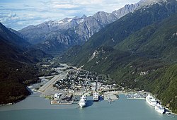 Aerial view of Skagway in 2009 | |
 Seal | |
| Nickname: "Gateway to the Klondike" | |
 Location of Skagway in Alaska | |
| Coordinates: 59°27′30″N 135°18′50″W / 59.45833°N 135.31389°W | |
| Country | |
| State | Alaska |
| Founded | 1897 |
| Incorporated (city) | June 28, 1900 |
| Incorporated (borough) | June 5, 2007 |
| Government | |
| • Mayor | Sam Bass[1] |
| • State senator | Jesse Kiehl (D) |
| • State rep. | Sara Hannan (D) |
| Area | |
| • Borough | 9.49 sq mi (24.59 km2) |
| • Land | 9.45 sq mi (24.46 km2) |
| • Water | 0.05 sq mi (0.12 km2) |
| Elevation | 33 ft (10 m) |
| Population (2020) | |
| • Borough | 1,240 |
| • Density | 130/sq mi (50/km2) |
| • Urban (CDP)[3] | 1,164 |
| Time zone | UTC−9 (AKST) |
| • Summer (DST) | UTC−8 (AKDT) |
| Zip Code | 99840 |
| Area code | 907 |
| FIPS code | 02-70760 |
| GNIS feature ID | 1414754 2339479 |
| Website | skagway.org |
Skagway was an important port during the Klondike Gold Rush. The White Pass and Yukon Route narrow gauge railroad, part of the area's mining past, is now in operation purely for the tourist trade and runs throughout the summer months. The port of Skagway is a popular stop for cruise ships, and the tourist trade is a big part of the business of Skagway. Skagway is also part of the setting for Jack London's book The Call of the Wild, Will Hobbs's book Jason's Gold, and for Joe Haldeman's novel, Guardian. The John Wayne film North to Alaska (1960) was filmed nearby.
The name Skagway (historically also spelled Skaguay) is the English divergent of sha-ka-ԍéi, a Tlingit idiom which figuratively refers to rough seas in the Taiya Inlet, which are caused by strong north winds.[6] (See, "Etymology and the Mythical Stone Woman", below.)
History edit
Etymology and the Mythical Stone Woman edit
Skagway is the English adaptation of sha-ka-ԍéi, a Tlingit idiom which figuratively refers to rough seas in the Taiya Inlet, that are caused by strong north winds.[6] Literally, sha-ka-ԍéi is a gerund (verbal noun) which means pretty woman.[7] The gerund was derived from the Tlingit finite verb theme -sha-ka-li-ԍéi, which means, in the case of a woman, to be pretty.[8]
The story behind the name is that Sha-ka-ԍéi or Skagway ["Pretty Woman"] was the nickname of Kanagoo, a mythical woman who transformed herself into stone at Skagway bay and who (according to the story) now causes the strong, channeled winds which blow toward Haines, Alaska.[9] The rough seas caused by these winds have therefore been referred to by the use of Kanagoo's nickname, Sha-ka-ԍéi or Skagway.[10]
The Kanagoo stone formation is now known as Face Mountain, which is seen from Skagway bay. The Tlingit name for Face Mountain is Kanagoo Yahaayí [Kanagoo's Image/Soul].[11] [Notes: The word which literally means rough seas is jiwsitaan. The phrase which means home of the north wind is xóon neili.[12]]
Early Skagway edit

One prominent resident of early Skagway was William "Billy" Moore, a former steamboat captain. As a member of an 1887 boundary survey expedition, he had made the first recorded investigation of the pass over the Coast Mountains, which later became known as White Pass. He believed that gold lay in the Klondike because it had been found in similar mountain ranges in South America, Mexico, California, and British Columbia. In 1887, he and his son, J. Bernard "Ben" Moore, claimed a 160-acre (650,000 m2) homestead at the mouth of the Skagway River in Alaska. Moore settled in this area because he believed it provided the most direct route to the potential goldfields. They built a log cabin, a sawmill, and a wharf in anticipation of future gold prospectors passing through.[citation needed]
The boundary between Canada and the United States along the Alaska Panhandle was only vaguely defined then (see Alaska boundary dispute). There were overlapping land claims from the United States' purchase of Alaska from Russia in 1867 and British claims along the coast. Canada requested a survey after British Columbia united with it in 1871, but the idea was rejected by the United States as being too costly, given the area's remoteness, sparse settlement, and limited economic or strategic interest.[citation needed]

The Klondike gold rush changed everything. In 1896, gold was found in the Klondike region of Canada's Yukon Territory. On July 29, 1897, the steamer Queen docked at Moore's wharf with the first boat load of prospectors. More ships brought thousands of hopeful miners into the new town and prepared for the 500-mile journey to the gold fields in Canada. Moore was overrun by lot jumping prospectors and had his land stolen from him and sold to others.[13]

The population of the general area increased enormously and reached 30,000, composed largely of American prospectors. Some realized how difficult the trek ahead would be en route to the gold fields, and chose to stay behind to supply goods and services to miners. Within weeks, stores, saloons, and offices lined the muddy streets of Skagway. The population was estimated at 8,000 residents during the spring of 1898 with approximately 1,000 prospective miners passing through town each week. By June 1898, with a population between 8,000 and 10,000, Skagway was the largest city in Alaska.[14]
Due to the sudden influx of visitors to Skagway, some town residents began offering miners transportation services to aid them in their journeys to the Yukon, often at highly inflated rates. A group of miners upset with the treatment organized a town council to help protect their interests. But as the members of the council moved north to try their own hands at mining, control of the town reverted to the more unscrupulous, most notably Jefferson Randolph "Soapy" Smith.[citation needed]

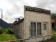


Between 1897 and 1898, Skagway was a lawless town, described by one member of the North-West Mounted Police as "little better than a hell on earth." Fights, prostitutes and liquor were ever-present on Skagway's streets, and con man "Soapy" Smith, who had risen to considerable power, did little to stop it. Smith was a sophisticated swindler who liked to think of himself as a kind and generous benefactor to the needy. He was gracious to some, giving money to widows and halting lynchings, while simultaneously operating a ring of thieves who swindled prospectors with cards, dice, and the shell game. His telegraph office charged five dollars to send a message anywhere in the world. Consequently, unknowing prospectors sent news to their families back home without realizing there was no telegraph service to or from Skagway until 1901.[15]
Smith also controlled a comprehensive spy network, a private militia called the Skaguay Military Company, the town newspaper, the Deputy U.S. Marshal's office and an array of thieves and con men who roamed about the town. Smith was finally shot and killed by Frank Reid and Jesse Murphy on July 8, 1898, in the famed Shootout on Juneau Wharf. Smith managed to return fire — some accounts claim the two men fired their weapons simultaneously — and Frank Reid died from his wounds twelve days later. Jesse Murphy is believed by some to be responsible for killing Smith, but the official coroner's inquest ruled "that said Smith [died] by reason of pistol wound piercing the heart. The said wound was the result of a pistol shot fired by one Frank H. Reid."[16][17]
Smith and Reid are now interred at the Klondike Gold Rush Cemetery, also known as "Skagway's Boot Hill."[18]
The prospectors' journey began for many when they climbed the mountains over the White Pass above Skagway and onward across the Canada–US border to Bennett Lake, or one of its neighboring lakes, where they built barges and floated down the Yukon River to the gold fields around Dawson City. Others disembarked at nearby Dyea, northwest of Skagway, and crossed northward on the Chilkoot Pass, an existing Tlingit trade route to reach the lakes. The Dyea route fell out of favor when larger ships began to arrive, as its harbor was too shallow for them except at high tide. Officials in Canada began requiring that each prospector entering Canada on the north side of the White Pass bring with him one ton (909 kg) of supplies, to ensure that he did not starve during the winter. This placed a large burden on the prospectors and the pack animals climbing the steep pass.[citation needed]
In 1898, a 14-mile, steam-operated aerial tramway was constructed up the Skagway side of the White Pass, easing the burden of those prospectors who could afford the fee to use it. The Chilkoot Trail tramways also began to operate in the Chilkoot Pass above Dyea. In 1896, before the Klondike gold rush had begun, a group of investors saw an opportunity for a railroad over that route. It was not until May 1898 that the White Pass and Yukon Route began laying narrow gauge railroad tracks in Skagway. The railroad depot was constructed between September and December 1898. This destroyed the viability of Dyea, as Skagway had both the deep-water port and the railroad. Construction of McCabe College, the first school in Alaska to offer a college preparatory high school curriculum, began in 1899. The school was completed in 1900.[citation needed]
By 1899, the stream of gold-seekers had diminished and Skagway's economy began to collapse. By 1900, when the railroad was completed, the gold rush was nearly over. In 1900, Skagway was incorporated as the first city in the Alaska Territory. Much of the history of Skagway was saved by early residents such as Martin Itjen, who ran a tour bus around the historical town. He was responsible for saving and maintaining the gold- rush cemetery from complete loss. He purchased Soapy Smith's saloon (Jeff Smith's Parlor) from going the way of the wrecking ball, and placed many early artifacts of the city's early history inside and opened Skagway's first museum.[19]
In July 1923, President Warren G. Harding visited Skagway while on his historic tour through Alaska. Harding was the first President of the United States to travel and tour Alaska while in office.[20][21] The Canol pipeline was extended to Skagway in the 1940s where oil was shipped in by sea and pumped north.[citation needed]
Geography edit

Skagway is located at 59°28′7″N 135°18′21″W / 59.46861°N 135.30583°W (59.468519, −135.305962).[22]
Skagway is located in a narrow glaciated valley at the head of the Taiya Inlet, the north end of the Lynn Canal, which is the most northern fjord on the Inside Passage on the south coast of Alaska.[23] It is in the Alaska panhandle 90 miles northwest of Juneau, Alaska's capital city.
According to the U.S. Census Bureau, the borough has a total area of 464 square miles (1,200 km2), of which 452 square miles (1,170 km2) is land and 12 square miles (31 km2) (2.5%) is water.[22] It is currently the smallest borough in Alaska, having taken the title away from Bristol Bay Borough at its creation.[citation needed]
Adjacent boroughs edit
- Haines Borough, Alaska – south, west
- Stikine Region, British Columbia – north, east
National protected areas edit
- Klondike Gold Rush National Historical Park (part, also in Seattle, Washington)
- Tongass National Forest (part)

Climate edit
Skagway has a humid continental climate (Köppen Dsb). It is in the rain shadow of the coastal mountains, and though not as pronounced as the rain shadow in Southcentral Alaska in the valley of the Susitna River, this still allows it to receive only half as much precipitation as Juneau and only a sixth as much as Yakutat. Although winters are too cold for the classification, precipitation patterns resemble a mediterranean climate due to the summer precipitation minimum. The highest temperature recorded in Skagway is 92 °F or 33.3 °C in three separate years, most recently in 2019, and the lowest is −24 °F or −31.1 °C on February 2, 1947.
North winds prevail at Skagway from November to March. South winds prevail from April to October.[24]
| Climate data for Skagway, Alaska, 1991–2020 normals, extremes 1898–present | |||||||||||||
|---|---|---|---|---|---|---|---|---|---|---|---|---|---|
| Month | Jan | Feb | Mar | Apr | May | Jun | Jul | Aug | Sep | Oct | Nov | Dec | Year |
| Record high °F (°C) | 55 (13) |
55 (13) |
63 (17) |
76 (24) |
82 (28) |
90 (32) |
92 (33) |
92 (33) |
83 (28) |
68 (20) |
56 (13) |
57 (14) |
92 (33) |
| Mean maximum °F (°C) | 45.8 (7.7) |
46.1 (7.8) |
50.5 (10.3) |
62.5 (16.9) |
73.4 (23.0) |
79.0 (26.1) |
77.8 (25.4) |
77.0 (25.0) |
67.1 (19.5) |
56.6 (13.7) |
47.3 (8.5) |
45.3 (7.4) |
82.3 (27.9) |
| Mean daily maximum °F (°C) | 29.2 (−1.6) |
32.8 (0.4) |
38.3 (3.5) |
50.4 (10.2) |
60.6 (15.9) |
66.3 (19.1) |
67.1 (19.5) |
65.0 (18.3) |
56.9 (13.8) |
47.3 (8.5) |
36.5 (2.5) |
31.5 (−0.3) |
48.5 (9.2) |
| Daily mean °F (°C) | 24.7 (−4.1) |
27.5 (−2.5) |
31.6 (−0.2) |
41.2 (5.1) |
50.4 (10.2) |
57.1 (13.9) |
59.1 (15.1) |
57.4 (14.1) |
50.4 (10.2) |
41.8 (5.4) |
31.8 (−0.1) |
27.5 (−2.5) |
41.7 (5.4) |
| Mean daily minimum °F (°C) | 20.2 (−6.6) |
22.2 (−5.4) |
24.9 (−3.9) |
32.0 (0.0) |
40.1 (4.5) |
47.7 (8.7) |
51.1 (10.6) |
49.7 (9.8) |
44.0 (6.7) |
36.2 (2.3) |
27.1 (−2.7) |
23.5 (−4.7) |
34.9 (1.6) |
| Mean minimum °F (°C) | 4.0 (−15.6) |
9.3 (−12.6) |
14.0 (−10.0) |
25.6 (−3.6) |
33.8 (1.0) |
41.4 (5.2) |
46.2 (7.9) |
43.9 (6.6) |
35.1 (1.7) |
27.7 (−2.4) |
16.3 (−8.7) |
9.3 (−12.6) |
−0.3 (−17.9) |
| Record low °F (°C) | −21 (−29) |
−24 (−31) |
−10 (−23) |
7 (−14) |
22 (−6) |
25 (−4) |
35 (2) |
24 (−4) |
20 (−7) |
8 (−13) |
−6 (−21) |
−22 (−30) |
−24 (−31) |
| Average precipitation inches (mm) | 2.65 (67) |
1.98 (50) |
1.98 (50) |
1.67 (42) |
1.14 (29) |
1.42 (36) |
1.62 (41) |
2.65 (67) |
4.51 (115) |
4.42 (112) |
3.42 (87) |
4.02 (102) |
31.48 (798) |
| Average snowfall inches (cm) | 9.2 (23) |
8.1 (21) |
8.6 (22) |
1.5 (3.8) |
0.0 (0.0) |
0.0 (0.0) |
0.0 (0.0) |
0.0 (0.0) |
0.0 (0.0) |
1.1 (2.8) |
5.9 (15) |
10.5 (27) |
44.9 (114.6) |
| Average precipitation days (≥ 0.01 in) | 13.8 | 10.5 | 9.5 | 11.5 | 9.0 | 11.2 | 12.2 | 14.9 | 17.4 | 18.2 | 13.6 | 13.1 | 154.9 |
| Average snowy days (≥ 0.1 in) | 7.4 | 4.8 | 4.2 | 0.9 | 0.0 | 0.0 | 0.0 | 0.0 | 0.0 | 0.3 | 3.3 | 6.6 | 27.5 |
| Source: NOAA[25][26] | |||||||||||||
Demographics edit
| Census | Pop. | Note | %± |
|---|---|---|---|
| 1900 | 3,117 | — | |
| 1910 | 872 | −72.0% | |
| 1920 | 494 | −43.3% | |
| 1930 | 492 | −0.4% | |
| 1940 | 634 | 28.9% | |
| 1950 | 758 | 19.6% | |
| 1960 | 659 | −13.1% | |
| 1970 | 675 | 2.4% | |
| 1980 | 768 | 13.8% | |
| 1990 | 692 | −9.9% | |
| 2000 | 862 | 24.6% | |
| 2010 | 968 | 12.3% | |
| 2020 | 1,240 | 28.1% | |
| 2023 (est.) | 1,095 | [27] | −11.7% |
| U.S. Decennial Census[28] | |||
Skagway first appeared on the 1900 U.S. Census, having incorporated as a city that same year. It was the 2nd largest city in Alaska, behind fellow Gold Rush boomtown Nome. It reported 3,117 residents, of which 2,845 were White, 113 were Native Americans, 98 were Black and 61 were Asian.[29] It rapidly declined to 872 residents by 1910, falling to the 8th largest city. It reported 802 Whites, 61 Native Americans and 9 Others.[30] It would be 90 years (until 2000) before it would almost reach that population again (862). It fell to 15th largest community overall in 1920. By 1930, it bottomed out at 492 residents, although it rose to 13th largest in the state. In 1940, it fell to 16th. By 1950, 19th. 1960, it tied for 29th place (16th largest incorporated). In 1970, it dropped to 45th (24th largest incorporated). In 1980, it rose to 35th place. In 1990, it fell to 53rd place. In 2000, it was at 60th place overall (29th largest incorporated). In 2007, with the creation of the Skagway Municipality out of Skagway-Hoonah-Angoon, it ceased to be an incorporated city and became a census-designated place (CDP). As of 2010, it is the 71st largest community in Alaska.
As of the census[31] of 2000, there were 862 people, 401 households, and 214 families residing in the city. The population density was 1.9 people per square mile (0.73 people/km2). There were 502 housing units at an average density of 1.1 per square mile (0.42/km2). The racial makeup of the city was 92.3% White, 3.0% Native American, 0.6% Asian, 0.2% Pacific Islander, 0.8% from other races, and 3.0% from two or more races. 2.1% of the population were Hispanic or Latino of any race.
There were 401 households, out of which 23.2% had children under the age of 18 living with them, 46.9% were married couples living together, 4.7% had a female householder with no husband present, and 46.4% were non-families. 36.2% of all households were made up of individuals, and 6.7% had someone living alone who was 65 years of age or older. The average household size was 2.15 and the average family size was 2.81.
In the city, the population was distributed with 20.5% under the age of 18, 5.2% from 18 to 24, 34.6% from 25 to 44, 31.2% from 45 to 64, and 8.5% who were 65 years of age or older. The median age was 40 years old. For every 100 females, there were 109.2 males. For every 100 females age 18 and over, there were 112.7 males.
| Year | Republican | Democratic | Third party | |||
|---|---|---|---|---|---|---|
| No. | % | No. | % | No. | % | |
| 2020 | 217 | 22.75% | 679 | 71.17% | 58 | 6.08% |
| 2016 | 232 | 27.65% | 449 | 53.52% | 158 | 18.83% |
| 2012 | 188 | 30.67% | 356 | 58.08% | 69 | 11.26% |
| 2008 | 217 | 38.07% | 317 | 55.61% | 36 | 6.32% |
| 2004 | 165 | 41.15% | 207 | 51.62% | 29 | 7.23% |
| 2000 | 247 | 49.90% | 156 | 31.52% | 92 | 18.59% |
| 1996 | 163 | 36.30% | 179 | 39.87% | 107 | 23.83% |
| 1992 | 178 | 37.32% | 154 | 32.29% | 145 | 30.40% |
| 1988 | 205 | 55.11% | 155 | 41.67% | 12 | 3.23% |
| 1984 | 215 | 59.39% | 132 | 36.46% | 15 | 4.14% |
| 1980 | 185 | 48.18% | 128 | 33.33% | 71 | 18.49% |
| 1976 | 230 | 67.45% | 99 | 29.03% | 12 | 3.52% |
| 1972 | 236 | 68.01% | 90 | 25.94% | 21 | 6.05% |
| 1968 | 155 | 57.41% | 95 | 35.19% | 20 | 7.41% |
| 1964 | 75 | 22.32% | 261 | 77.68% | 0 | 0.00% |
| 1960 | 100 | 31.15% | 221 | 68.85% | 0 | 0.00% |
Economy edit
Personal income edit
The median income for a household in the city was $49,375, and the median income for a family was $62,188. Males had a median income of $44,583 versus $30,956 for females. The per capita income for the city was $27,700. About 1.0% of families and 3.7% of the population were below the poverty line, including none of those under age 18 and 4.5% of those age 65 or over.
Tourism edit


There are visitors to the Klondike Gold Rush National Historical Park and White Pass and Chilkoot Trails. Skagway has a historical district of about 100 buildings from the gold rush era. It receives about a million tourists annually,[citation needed] most of whom (about three quarters) come on cruise ships. The White Pass and Yukon Route operates its narrow-gauge train around Skagway during the summer months, primarily for tourists. The WPYR also ships copper ore from the interior.
Transportation edit


Skagway is one of three Southeast Alaskan communities that are connected to the road system; Skagway's connection is via the Klondike Highway, completed in 1978. This allows access to the lower 48, Whitehorse, Yukon, northern British Columbia, and the Alaska Highway. This also makes Skagway an important port-of-call for the Alaska Marine Highway — Alaska's ferry system — and serves as the northern terminus of the important and heavily used Lynn Canal corridor. (The other Southeast Alaskan communities with road access are Haines and Hyder.)
The White Pass and Yukon Route is a railway that formerly linked Whitehorse, Yukon in Canada to Skagway, the railway's southernmost terminus. Today[when?], trains travel several times a week from May through September from Skagway to the small community of Carcross, approximately 45 miles south/southwest of Whitehorse. There, passengers (mostly tourists) can make connections via bus to Whitehorse.
Skagway Airport receives service from two bush carriers: Alaska Seaplanes, and Air Excursions.
Media edit
Local radio and newspapers edit
Skagway is served by its local semimonthly newspaper, The Skagway News, as well as regional public radio station KHNS, which has its principal studios in nearby Haines but also has studios and programs based in Skagway. Juneau radio station KINY operates a translator in Skagway which serves the entire town.
Skagway also receives copies of the free regional newspaper Capital City Weekly.
Featured in media edit
Skagway and the surrounding goldfields in 1897-8 is the main setting for George Markstein's 1978 novel 'Tara Kane′, which also features fictionalised versions of Jefferson 'Soapy' Smith and his gang, along with photographer Eric A. Hegg (called Ernst Hart in the novel).
In the Three Stooges short In the Sweet Pie and Pie, Skagway receives a humorous mention: "Edam Neckties, with three convenient locations: Skagway, Alaska; Little America; and Pago Pago."
Skagway is a featured setting in the 1946 film Road to Utopia, starring Bob Hope and Bing Crosby.
In Jack London's short story "The Unexpected," the main characters spend the winter of 1897–98 in "the mushroom outfitting-town of Skaguay" before moving on to stake a gold-mining claim elsewhere.
Skagway is featured in the 1955 Western The Far Country, directed by Anthony Mann.
Skagway is a town featured in the computer game The Yukon Trail.
Skagway and the surrounding region is a campaign available in a modification of the helicopter combat simulator "Enemy Engaged: Comanche vs. Hokum" (version 1.16.0)
In an episode of Homeland Security USA, the border crossing in Skagway was featured as being the least-used crossing in the United States.
Chief Inspector Fenwick often dryly referred to nearby "big city" "Skagway" when sending his mounty, Dudley Do-Right, to capture the show's evil nemesis, Snidely Whiplash.
Skagway's Mo Mountain Mutts came to prominence in 2023 when its "puppy bus" video went viral.
Health care edit
Skagway is served by Dahl Memorial Clinic, the only primary health clinic in the area. The facility is usually staffed by 3 Advanced Nurse Practitioners and 3 Medical Assistants and is open Monday through Friday year-round with limited Saturday hours during summer.[citation needed] The clinic also operates after hours in emergency situations. The borough is also served 24/7 by local EMS. Individuals in need of dire medical attention are transported by air via helicopter or air ambulance to Bartlett Regional Hospital in Juneau (an approximately 45 minute flight). Whitehorse General Hospital in Whitehorse, Yukon is the nearest hospital to Skagway that is accessible by road (an approximately 2 hour drive).
References edit
- ^ "Municipality of Skagway Borough". skagway.org. Retrieved October 14, 2023.
- ^ "2020 U.S. Gazetteer Files". United States Census Bureau. Retrieved October 29, 2021.
- ^ a b "2020 Census Data - Cities and Census Designated Places" (Web). State of Alaska, Department of Labor and Workforce Development. Retrieved October 31, 2021.
- ^ "U.S. Census Bureau QuickFacts". United States Census Bureau. Retrieved September 29, 2018.
- ^ a b June 5, 2008, election, Skaguay News, summer edition, 2008. Page 17.
- ^ a b "Most [1995-2002 Tlingit-speaking informants] agreed that the name [Sha-ka-ԍéi] refers to the effect of the strong north wind on the waters of Lynn Canal, which generates rugged seas and 'wrinkled up' waves." Thornton, Thomas F. (2004). Klondike Gold Rush National Historic Park Ethnographic Overview and Assessment. U.S. Dept. of Interior., at page 53.
- ^ "[S]he was simply called Skagway ('the beautiful one')." Emmons, George T. (unpublished, 1916). History of Tlingit Tribes and Clans. B.C. Archives, reproduced in, Thornton (2004). Klondike Gold Rush National Historic Park Ethnographic Overview and Assessment., at page 19.
- ^ See, Edwards, Keri (2009). Dictionary of Tlingit (PDF). Sealaska Heritage Institute. p. 107 (This verb is used to describe a beautiful woman). ISBN 978-0-9825786-6-7. Retrieved September 14, 2015.. The gerund was created by omitting the verb classifier "-li-". Without an adjacent verb classifier, a Tlingit verb root will become a gerund. See, Id. at page 328 ( | .áa | [without classifier] = sitting [gerund]).
- ^ "A local myth is connected with a rock in the [Taiya] Valley which is supposed to be a woman turned to stone who, under the name of Kanuga [i.e., Kanagoo], is regarded as the bringer of wind. In the months of February and March, 1882, when there were exceptionally strong winds, it was said among the Chilkat that Kanuga was angry ..." Krause, Aurel (1885). The Tlingit Indians. Translated by Erna Gunther (translated 1956). Univ. of Washington Press.; Krause, Aurel, and Arthur Krause (1993). To the Chukchi Peninsula and to the Tlingit Indians 1881/1882. University of Alaska Press. ISBN 978-0-912006-66-6.
{{cite book}}: CS1 maint: multiple names: authors list (link), at pp. 158, 230 (note 22: “goddess Kanuga – A mythical woman who is supposed to have turned to stone and unleashes winds when angry; the rock is in the Taiya Valley.”); 120, 158, 202 (“Kanuga, the personified river that empties into the [Taiya] Valley” is also shown on the maps as Schkaguḗ [Skagway]); 195 (two bays in Taiya Inlet), 197-98 (Kanagu lives in the first bay); Emmons (1916). History of Tlingit Tribes and Clans, reproduced in, Thornton (2004). Klondike Gold Rush National Historic Park Ethnographic Overview and Assessment., at page 19 ("[T]he name Skagway is reportedly derived from the following legend … 'The rock wall opened and she disappeared forever. But when the North wind blows down from the White Pass, laden with the chill of the north, it was believed to be the breath of her spirit …' "). It is apparent that Kanagoo and Skagway are the same personage, and that Skagway is the nickname. A phrase meaning pretty woman is too common to be proprietary. Because Tlingit given names were considered proprietary, Kanagoo would be the given name and Skagway would be the nickname. - ^ "Ben" Moore described the name Skagway as "an Indian name the meaning of which would take too long to explain in detail." Moore, James Bernard (1997). Skagway in Days Primeval: The Writings of J. Bernard Moore, 1886-1904. Lynn Canal Publishing. ISBN 0-945284-06-3., between pp. 96-97 (August 2, 1904, Skagway Speech). Ben and his father founded Skagway, Ben's wife was a Tlingit Indian, and Ben did business with the Tlingits. Under those circumstances, he would have learned the meaning of Skagway, and the Kanagoo-related meaning fits his description of "long" and "detail[ed]."
- ^ Arthur Krause had reported that "Kanagu … lives in [Skagway] bay." Krause and Krause (1993). To the Chukchi Peninsula and to the Tlingit Indians., at pp. 195, 197-98. Face Mountain's Tlingit name is Kanagoo Yahaayí. Thornton (2012). Haa Léelk'w Hás Aaní Saax'ú (PDF). pp. 52–53. Retrieved February 22, 2017. Yahaayí is an inalienable noun, which may mean the image of the noun that precedes it, or the soul of the noun that precedes it. Edwards (2009). Dictionary of Tlingit (PDF). pp. 317, 406, 460. Retrieved September 14, 2015. Face Mountain is a little of each. From 1897 to 1985, the official name of Face Mountain was Parsons Peak. Orth (1967). Dictionary of Alaska Place Names., at page 740 (Parsons Peak). Nevertheless, people usually called it “Face Mountain” and therefore, in 1985, Face Mountain became the official name. Decisions on Geographic Names in the United States October through December 1985: Decision List No. 8584. U.S. Dept. of Interior, at page 1 (Face Mountain).
- ^ Edwards (2009). Dictionary of Tlingit (PDF). pp. 231 (TAAN jiwsitaan), 446 (rough), 287 (xóon), 486 (wind), 197 (neil), 404 (home), 16 (When possessed, alienable nouns require the possession suffix [y]i). Retrieved September 14, 2015.
- ^ Skaguay News (summer ed.), 2008, p. 16
- ^ "Skagway Alaska". Alaska Trekker. Archived from the original on November 27, 2017. Retrieved July 8, 2018.
- ^ Collier's Weekly, November 9, 1901
- ^ Inquest Records, 1898–1935, Historic Records of the Office of the Magistrate, City of Skagway, Volume 55, Microfilm 176, Alaska State Archives, Juneau: "Inquest of Jeff R. Smith," p. 6
- ^ Smith, Jeff (2009). Alias Soapy Smith: The Life and Death of a Scoundrel. Juneau, Alaska: Klondike Research. ISBN 978-0-9819743-0-9.
- ^ "Skagway Spectacular Sightseeing Tours, Skagway Tours, Skagway Alaska Tours, Skagway Tour, Skagway Train Ride, White Pass, White Pass Railroad Train Ride, AK". southeasttours.com. Archived from the original on September 8, 2012. Retrieved July 8, 2018.
- ^ "Jeff. Smiths Parlor Museum - Klondike Gold Rush National Historical Park (U.S. National Park Service)". nps.gov. Retrieved July 8, 2018.
- ^ "Skagway, Alaska ... Then & Now". May 31, 2008. Retrieved February 5, 2011.
- ^ "Warren G. Harding - Life Facts". C-SPAN. Archived from the original on July 8, 2000. Retrieved September 18, 2016.
- ^ a b "US Gazetteer files: 2010, 2000, and 1990". United States Census Bureau. February 12, 2011. Retrieved April 23, 2011.
- ^ "Skagway – Forest Service" (PDF). USDA. Retrieved May 18, 2018.
- ^ United States Coast Pilot: Alaska: Part I. U.S. Dept. of Commerce. 1932. p. 474. Retrieved November 4, 2021.
- ^ "NOWData – NOAA Online Weather Data". National Oceanic and Atmospheric Administration. Retrieved June 25, 2021.
- ^ "Summary of Monthly Normals 1991–2020". National Oceanic and Atmospheric Administration. Retrieved June 25, 2021.
- ^ "Annual Estimates of the Resident Population for Counties: April 1, 2020 to July 1, 2023". United States Census Bureau. Retrieved March 28, 2024.
- ^ "Census of Population and Housing". Census.gov. Retrieved June 4, 2016.
- ^ "Census data" (PDF). www2.census.gov.
- ^ "Census data" (PDF). www2.census.gov.
- ^ "U.S. Census website". United States Census Bureau. Retrieved May 14, 2011.
- ^ "RRH Elections". rrhelections.com. February 2, 2018. Retrieved December 24, 2021.
External links edit
- The Municipality of Skagway Borough
- Skagway Chamber of Commerce
- Skagway Convention & Visitors Bureau
- Skagway-Hoonah-Angoon Census Area map, 2000 census: Alaska Department of Labor
- Borough map, 2000 census: Alaska Department of Labor
- Borough map, 2010 census: Alaska Department of Labor
- The Skagway News local newspaper
- Soapy Smith Preservation Trust
- Alaska Community Database Community Information Summaries
- University of Washington Libraries Digital Collections – Eric A. Hegg Photographs 736 photographs from 1897 to 1901 documenting the Klondike and Alaska gold rushes, including depictions of frontier life in Skagway and Nome, Alaska and Dawson, Yukon Territory. Keyword search on "Skagway".
- ”Skagway: Gateway to the Klondike”, a National Park Service Teaching with Historic Places (TwHP) lesson plan
- Skagway, Alaska at Curlie