


Summary
The theory of Portuguese discovery of Australia claims that early Portuguese navigators were the first Europeans to sight Australia between 1521 and 1524, well before the arrival of Dutch navigator Willem Janszoon in 1606 on board the Duyfken who is generally considered to be the first European discoverer. While lacking generally accepted evidence, this theory is based on the following:[3][4]: 6
- The Dieppe maps, a group of 16th-century French world maps, depict a large landmass between Indonesia and Antarctica. Labelled as Java la Grande, this landmass carries French, Portuguese, and Gallicized Portuguese placenames, and has been interpreted by some as corresponding to Australia's northwestern and eastern coasts.
- The proximity of Portuguese colonies in Southeast Asia from c. 1513–1516, particularly Portuguese Timor which is approximately 650 kilometres (400 mi) from the Australian coast.[5][6][7]
- Various antiquities found on Australian coastlines, claimed by some to be relics of early Portuguese voyages to Australia but which are generally regarded as evidence of Makassan visit to Northern Australia.


Precedence for earliest non-Aboriginal visits to Australia has also been claimed for China (Admiral Zheng),[8] France,[a] Spain,[b] and even Phoenicia,[11][12] also all without generally accepted evidence.
Historiography edit
Development of the theory in the 19th century edit
Although Scotsman Alexander Dalrymple wrote on this topic in 1786,[13] it was Richard Henry Major, Keeper of Maps at the British Museum, who in 1859 first made significant efforts to prove the Portuguese visited Australia before the Dutch.[14] A group of mid-16th-century French maps, the Dieppe maps, formed his main evidence. However, there is widespread agreement today that his approach to historical research was flawed and his claims often exaggerated.[15]: 358 [16]: 42–43 Writing in an academic journal in 1861, Major announced the discovery of a map by Manuel Godinho de Eredia,[17] claiming it proved a Portuguese visit to North Western Australia, possibly dated to 1601.[18] In fact, this map's origins are from 1630.[16]: 42 On finally locating and examining Erédia's writings, Major realised the planned voyage to lands south of Sumba in Indonesia had never taken place. Major published a retraction in 1873, but his reputation was destroyed.[15]: 367–368 Major's interpretation was examined critically by the Portuguese historian Joaquim Pedro de Oliveira Martins, who concluded that neither the patalie regiã on the 1521 world map of Antoine de La Sale[19] nor the Jave la Grande on the Dieppe Maps was evidence of Australia having been visited by Portuguese visitors in the first quarter of the sixteenth century, but that this feature had found its way on to the maps from descriptions of islands of the Sunda archipelago beyond Java collected from native informants by the Portuguese.[20]

In 1895, George Collingridge produced his The Discovery of Australia, an attempt to trace all European efforts to find the Great Southern Land to the time of Cook, and also introducing his interpretation of the theory of Portuguese visitation of Australia, using the Dieppe maps.[21] Fluent in Portuguese and Spanish, Collingridge was inspired by the publicity surrounding the arrival in Australia of copies of several Dieppe maps, which had been purchased by libraries in Melbourne, Adelaide and Sydney.[22] Despite a number of errors regarding place names,[16]: 43 and "untenable" theories to explain misplacement on the Dieppe maps,[15]: 375 his book was a remarkable effort considering it was written at a time when many maps and documents were inaccessible and document photography was still in its infancy. Collingridge's theory did not find public approval, however, and Professors G. Arnold Wood and Ernest Scott publicly criticised much of what he had written. Collingridge produced a shorter version of this book for use in New South Wales schools; The First Discovery of Australia and New Guinea.[23] It was not used.
Professor Edward Heawood also provided early criticism of the theory. In 1899 he noted that the argument for the coasts of Australia having been reached early in the 16th century rested almost entirely on the supposition that at that time, "a certain unknown map-maker drew a large land, with indications of definite knowledge of its coasts, in the quarter of the globe in which Australia is placed". He pointed out that "a difficulty arises from the necessity of supposing at least two separate voyages of discovery, one on each coast, though absolutely no record of any such exists". He added: "The difficulty, of course, has been to account for this map in any other way". The delineation of Japan in the Dieppe maps, the insertion in them of an Isle des Géants in the southern Indian Ocean, and of Catigara on the west coast of South America, and in their later versions the depiction of a fictitious coastline of a southern continent with numerous bays and rivers, showed the slight reliance to be placed on them with respect to outlying parts of the world and the influence still exercised on their makers by the old writers". He concluded: "This should surely make us hesitate to base so important assumption as that of a discovery of Australia in the sixteenth century on their unsupported testimony".[24]
Kenneth McIntyre and development of the theory in the 20th century edit

The development of the theory of Portuguese discovery of Australia owes much to Melbourne lawyer Kenneth McIntyre's 1977 book, The Secret Discovery of Australia; Portuguese ventures 200 years before Cook. McIntyre's book was reprinted in an abridged paperback edition in 1982 and again in 1987[25] and it was found on school history reading lists by the mid-1980s.[26] According to Dr. Tony Disney, McIntyre's theory influenced a generation of history teachers in Australian schools.[27] A TV documentary was made of the book in the 1980s by Michael Thornhill[28] and McIntyre and the theory featured in many positive newspaper reviews and articles over the next twenty years.[29] Australian history school textbooks also reflect the evolution of acceptance of his theories.[30] The support of Dr. Helen Wallis, Curator of Maps at the British Library during her visits to Australia in the 1980s seemed to add academic weight to McIntyre's theory.[31] In 1987, the Australian Minister for Science, Barry Jones, launching the Second Mahogany Ship Symposium in Warrnambool, said "I read Kenneth McIntyre's important book ... as soon as it appeared in 1977. I found its central argument ... persuasive, if not conclusive."[32] The appearance of variant but essentially supporting theories in the late 1970s and early 1980s by other writers, including Ian McKiggan[33] and Lawrence Fitzgerald[34] also added credence to the theory of Portuguese discovery of Australia. In 1994, McIntyre expressed pleasure that his theory was gaining acceptance in Australia: "It is gradually seeping through. The important thing is that ... it has been on the school syllabus, and therefore students have ... read about it. They in due course become teachers and ... they will then tell their students and so on".[35]
Purported evidence and arguments edit
Interpretation of the Dieppe Maps edit
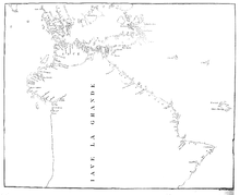
The central plank of the theory of Portuguese discovery of Australia suggests the continent called Jave la Grande, which uniquely appears on a series of 16th-century French world maps, the Dieppe school of maps, represents Australia. Speaking in 1982, Kenneth McIntyre described the Dieppe maps as "the only evidence of Portuguese discovery of Eastern Australia". He stressed this to point out "that the Mahogany Ship, and the Geelong Keys, and other things of that sort, are not part of the proof that the Portuguese discovered Australia. It is the other way around. The Dieppe maps prove (sic) that the Portuguese discovered Australia, and this throws a fierce bright light on our mysteries such as the Mahogany Ship".[36] Later writers on the same topic take the same approach of concentrating primarily on "Jave la Grande" as it appears in the Dieppe maps, including Fitzgerald, McKiggan and most recently, Peter Trickett.[37] Critics of the theory of Portuguese discovery of Australia, including A. Ariel, M. Pearson, W. A. R. Richardson, Gayle K. Brunelle and Robert J. King also concentrate on the "Jave la Grande" landmass of the Dieppe maps (see below).
W. A. R. Richardson argues that Jave la Grande as it appears on the Dieppe world maps is at least partly based on Portuguese sources that no longer exist.[16]: 5 McIntyre attributed discrepancies between the Jave la Grande coastline and Australia's to the difficulties of accurately recording positions without a reliable method of determining longitude, and the techniques used to convert maps to different projections.
In the late 1970s, mathematician Ian McKiggan developed his theory of exponential longitude error theory to explain discrepancies,[33] although he modified this position after a public exchange of opinion with W. A. R. Richardson.[38] McIntyre's own theory about distortion of the maps and the calculations used to correct the maps has also been challenged.[39][40] Both Lawrence Fitzgerald and Peter Trickett argue Jave la Grande is based on Portuguese sea charts, now lost, which the mapmakers of Dieppe misaligned. Both these writers try to compare the coastal features of Jave la Grande with modern Australia's, by realigning them.
In 1994, McIntyre suggested that the writings of Pedro Nunes supported his interpretation of the distortion that occurred on the Dieppe Maps.[41]
Helen Wallis, Keeper of Maps at the British Museum, referred in 1988 to the interpretation "explosion" on the subject of the Dieppe maps.[42] She herself argued the case for discovery of Australia by "a local Portuguese voyage otherwise unknown" seventy years before the Dutch, a chart of which was "presumably" brought back to Dieppe by the survivors of a French voyage to Sumatra led by Jean Parmentier in 1529–30.[43]
Cristóvão de Mendonça's role edit
Cristóvão de Mendonça is known from a small number of Portuguese sources, notably the famous Portuguese historian João de Barros in Décadas da Ásia (Decades of Asia), a history of the growth of the Portuguese Empire in India and Asia, published between 1552–1615.[44] Mendonça appears in Barros' account with instructions to search for the legendary Isles of Gold. However, Mendonça and other Portuguese sailors are then described as assisting with the construction of a fort at Pedir (Sumatra) and Barros does not mention the expedition again.[45]
McIntyre nominated Cristóvão de Mendonça as the commander of a voyage to Australia c. 1521–1524, one he argued had to be kept secret because of the 1494 Treaty of Tordesillas, which divided the undiscovered world into two-halves for Portugal and Spain. Barros and other Portuguese sources do not mention a discovery of land that could be Australia, but McIntyre conjectured this was because original documents were lost in the 1755 Lisbon earthquake,[46] or the official policy of silence.[47]
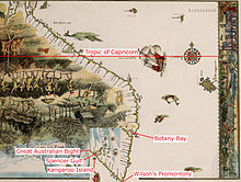
Most proponents of the theory of Portuguese discovery of Australia have supported McIntyre's hypothesis that it was Mendonça who sailed down the eastern Australian coast and provided charts which found their way onto the Dieppe maps, to be included as "Jave la Grande" in the 1540, 1550s and 1560s. McIntyre claimed the maps indicated Mendonça went as far south as Port Fairy, Victoria;[48] Fitzgerald claims they show he went as far as Tasmania;[49] Trickett states as far as Spencer Gulf in South Australia,[50] and New Zealand's North Island.[51]
Claims of Portuguese words in Aboriginal Australian languages edit
In the 1970s and 1980s, linguist Carl Georg von Brandenstein, approaching the theory from another perspective, claimed that 60 words used by Aboriginal people of the Australian north-west had Portuguese origins.[52] According to Peter Mühlhäusler of the University of Adelaide:
Von Brandenstein discusses a number of words in Pilbara [Aboriginal Australian] languages which show some resemblances with Portuguese (and Latin) words, and concludes that perhaps fifteen out of a total of sixty might be borrowings from either Portuguese or Latin. The most convincing is the word for 'turtle' in various Pilbara languages including Ngarluma, Karierra, Ngarla, Yinjibarndi, and Nyamal, which is "tartaruga" or "thartaruga" – the former being identical to the Portuguese word for this animal. Such borrowings must presumably date to the early Portuguese interception of the Pilbara coast, and indicate that the Portuguese did communicate with the Aboriginal people of the Pilbara coast. Again, however there is no evidence that the contacts were intensive or extensive enough to give rise to any contact language.[53]
Von Brandenstein also claimed the Portuguese had established a "secret colony ... and cut a road as far as the present day town of Broome"[54] and that "stone housing in the east Kimberley could not have been made without outside influence".[55] However, according to Nicholas Thieberger, modern linguistic and archaeological research has not corroborated his arguments.[56] Mühlhäusler agrees, stating that "von Brandenstein's evidence is quite unconvincing: his historical data is speculative – the colonisation being clandestine, there are no written records of it and his claims are not supported by the linguistic evidence he cites."[53]
Other purported textual and cartographic evidence edit
In contemporary Australia, reports of textual and cartographic evidence, of varying significance, and occasionally artifacts are sometimes cited as likely to "rewrite" Australian History because they suggest a foreign presence in Australia.[57][58][59][60] In January 2014, a New York Gallery listed a sixteenth-century Portuguese manuscript for sale, one page of which contained marginalia of an unidentified animal that the Gallery suggested might be a kangaroo. Dr. Martin Woods of the National Library of Australia commented: "The likeness of the animal to a kangaroo or wallaby is clear enough, but then it could be another animal in south-east Asia, like any number of deer species.... For now, unfortunately the appearance of a long-eared big-footed animal in a manuscript doesn't really add much."[61] Dr. Peter Pridmore of La Trobe University has suggested the marginalia depicts an aardvark.[62]
Speculum Orbis Terrae edit

Other texts originating from the same era represent a land to the south of New Guinea, with a variety of flora and fauna. Part of a map in Cornelis de Jode's 1593 atlas Speculum Orbis Terrae depicts New Guinea and a hypothetical land to the south inhabited by dragons.[63][64] Kenneth McIntyre suggested that although Cornelis de Jode was Dutch, the title page of Speculum Orbis Terrae may provide evidence of early Portuguese knowledge of Australia.[15]: 232 The page depicts four animals: a horse, representing Europe, a camel, to represent Asia, a lion, for Africa, and another animal that resembles a kangaroo, to represent a fourth continent. The latter creature features a marsupial pouch containing two offspring, and the characteristically bent hind legs of a kangaroo or another member of the macropod family. However, as macropods (including the dusky pademelon, agile wallaby, and black dorcopsis) are found in New Guinea and the Bismarck Archipelago, this may have no relevance to a possible Portuguese discovery of Australia. Another explanation is that the animal is based on a North American opossum.[16]: 48
James Cook and Cooktown harbour edit
On 11 June 1770, James Cook's Endeavour struck a coral reef (now known as Endeavour Reef) off the coast of what is now Queensland. It was a potentially catastrophic event and the ship immediately began to take water. However, over the next four days the ship managed to limp along, searching for safety. In 1976, McIntyre suggested that Cook had been able to find a large harbour (Cooktown harbour) because he had access to a copy of one of the Dieppe maps.[65] McIntyre felt Cook's comment in his Journal, which at the 1982 Mahogany ship Symposium he cited as "this harbour will do excellently for our purposes, although it's not as large as I had been told",[66] indicated he carried a copy of or had seen a copy of the Dauphin Map, and by implication was using it to chart his way along the eastern Australian coast. McIntyre acknowledged in his book that Cook may have been told this by the lookout or boat crew, but added it was a "peculiar remark to make."[15]: 349 Reference to this remained in subsequent editions of The Secret Discovery of Australia.[67]
In 1997, Ray Parkin edited a definitive account of Cook's voyage of 1768–1771, transcribing the Endeavour's original log, Cook's Journal and accounts by other members of the crew.[68] Parkin transcribed the relevant Journal entry as "...anchored in 4 fathom about a mile from the shore and then made a signal for the boats to come onboard, after which I went myself and buoy’d the channel which I found very narrow and the harbour much smaller than I had been told but very convenient for our purpose."[69] The log for 14 June also mentions the ship's boats sounding the way for the crippled Endeavour.[70] Nevertheless, the influence of McIntyre's interpretation can still be seen in contemporary Australian school curriculum materials.[71]
Purported evidence from relics edit
Mahogany Ship edit
According to McIntyre, the remains of one of Cristóvão de Mendonça's caravels was discovered in 1836 by a group of shipwrecked whalers while they were walking along the sand dunes to the nearest settlement, Port Fairy.[72] The men came across the wreck of a ship made of wood that appeared to be mahogany. Between 1836 and 1880, 40 people[73] recorded that they had seen an "ancient" or "Spanish" wreck. Whatever it was, the wreck has not been seen since 1880, despite extensive searches in recent times. McIntyre's accuracy in transcribing original documents to support his argument has been criticized by some recent writers.[74] Dr. Murray Johns' 2005 survey of 19th-century accounts of the Mahogany Ship suggests that the eyewitness accounts actually relate to more than one shipwreck in the area. Johns concludes these wrecks were of early 19th-century Australian construction and are unrelated to Portuguese maritime activity.[75]
The Geelong Keys edit
In 1847, at Limeburners Point, near Geelong, Victoria, Charles La Trobe, a keen amateur geologist, was examining shells and other marine deposits revealed by excavations associated with lime production in the area. A worker showed him a set of five keys he claimed to have found the day before. La Trobe concluded that the keys had been dropped onto what had been the beach around 100–150 years before. Kenneth McIntyre hypothesised they were dropped in 1522 by Mendonça or one of his sailors. Since the keys have been lost, however, their origin cannot be verified.
A more likely explanation is that the "much decayed" keys were dropped by one of the limeburners shortly before being found, as the layer of dirt and shells they were found below was dated as around 2300–2800 years old, making La Trobe's dating implausible. According to geologist Edmund Gill, and engineer and historian Peter Alsop, the error by La Trobe is quite understandable, given that in 1847 most Europeans thought the world was only 6000 years old.[76]
Cannon edit
In 1916, two bronze cannon were found on a small island in Napier Broome Bay, on the Kimberly coast of Western Australia. Since the guns were erroneously thought to be carronades, the small island was named Carronade Island.[77][78]
Kenneth McIntyre believed the cannons gave weight to the theory of Portuguese discovery of Australia.[79] However, scientists at the Western Australian Museum in Fremantle made a detailed analysis of the weapons, and determined that they are swivel guns, and almost certainly of late 18th-century Makassan, rather than European, origin. The claim that one of the guns displays a Portuguese "coat of arms" is incorrect.[77][80]
In January 2012, a swivel gun found two years before at Dundee Beach near Darwin was widely reported by web news sources and the Australian press to be of Portuguese origin.[57][81] However, later analysis by the Museum and Art Gallery of the Northern Territory indicated it was also of Southeast Asian origin.[82][83] Further analysis suggests that the lead in the gun most closely resembles that from Andalusia in Spain, although it may have been recycled in Indonesia.[84] The museum holds seven guns of Southeast Asian manufacture in its collection. Another swivel gun of Southeast Asian manufacture, found in Darwin in 1908, is held by the Museum of South Australia.[85][86] In 2014, it was revealed that sand inside the Dundee beach gun was dated to 1750.[87]
Bittangabee Bay edit
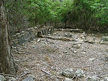
Kenneth McIntyre first suggested in 1977 that the stone ruins at Bittangabee Bay, in Beowa National Park near Eden on the south coast of New South Wales, were of Portuguese origin.[88]
The ruins are the foundations of a building, surrounded by stone rubble that McIntyre argued may have once formed a defensive wall. McIntyre also identified the date 15?4 carved into a stone.[89] McIntyre hypothesized the crew of a Portuguese caravel may have built a stone blockhouse and defensive wall while wintering on a voyage of discovery down Australia's east coast.
Since McIntyre advanced his theory in 1977, significant research on the site has been conducted by Michael Pearson, former Historian for the NSW Parks and Wildlife Service.[90] Pearson identified the Bittangabee Bay ruins as having been built as a store house by the Imlay brothers, early European inhabitants, who had whaling and pastoral interests in the Eden area. The local Protector of Aborigines, George Augustus Robinson, wrote about the commencement of the building in July 1844. The building was left unfinished at the time of the death of two of the three brothers in 1846 and 1847.
Other visitors and writers, including Lawrence Fitzgerald,[91] have been unable to find the 15?4 date. Writing in Beyond Capricorn in 2007, Peter Trickett suggests the date McIntyre saw may be random pick marks in the stonework.[92]
Trickett accepts Pearson's work, but hypothesizes that the Imlays may have started their building on top of a ruined Portuguese structure, thus explaining the surrounding rocks and partly dressed stones. Trickett also suggests the Indigenous Australian name for the area may have Portuguese origins.[93]
Kilwa Sultanate coins edit
In 1944, nine coins were found on Marchinbar Island by RAAF radar operator Maurie Isenberg. Four coins were identified as Dutch duits dating from 1690 to the 1780s, while five with Arabic inscriptions were identified as being from the Kilwa Sultanate of east Africa.[94] The coins are now held by the Powerhouse Museum, Sydney.[95] In 2018 another coin, also thought to be from Kilwa, was found on a beach on Elcho Island, another of the Wessel Islands, by archaeologist and member of the Past Masters group, Mike Hermes. Hermes speculated that this may indicate trade between indigenous Australians and Kilwa, or that they coins had arrived as a result of Makassan contact with Australia.[96] Ian S McIntosh's view is also that the coins were "probably introduced by sailors from Makassar... in the first wave of trepanging and exploration in the 1780s."
Criticisms and alternative views of the Dieppe Maps edit
Possibly because of the degree of conjecture involved in the theory of Portuguese discovery of Australia, there have been a number of critics. Matthew Flinders cast a sceptical eye over the "Great Java" of the Dieppe maps in A Voyage to Terra Australis, published in 1814, and concluded: "it should appear to have been partly formed from vague information, collected, probably, by the early Portuguese navigators, from the eastern nations; and that conjecture has done the rest. It may, at the same time, be admitted, that a part of the west and north-west coasts, where the coincidence of form is most striking, might have been seen by the Portuguese themselves, before the year 1540, in their voyages to, and from, India".[97]
In the last chapter of The Secret Discovery of Australia, Kenneth McIntyre threw down a challenge, stating: "Every critic who seeks to deny the Portuguese discovery of Australia is faced with the problem of providing an alternative theory to explain away the existence of the Dieppe maps. If the Dauphin is not the record of real exploration, then what is it?"[98]
By far the most prolific writer on this theory, and also its most consistent critic, has been Flinders University Associate Professor W.A.R. (Bill) Richardson, who has written 20 articles relating to the topic since 1983.[99] Richardson, an academic fluent in Portuguese and Spanish, first approached the Dieppe maps in an effort to prove they did relate to Portuguese discovery of Australia. His criticisms are therefore all the more interesting. He suggests that he quickly realised that there was no connection between the Dieppe maps and modern Australia's coastline:[16]: 6
The case for an early Portuguese discovery of Australia rests entirely on imagined resemblances between the "continent" of Jave La Grande on the Dieppe maps and Australia. There are no surviving Portuguese 16th-century charts showing any trace of land in that area, and there are no records whatsoever of any voyage along any part of the Australian coastline before 1606. Advocates of the Portuguese discovery theory endeavour to explain away this embarrassing lack of direct supporting evidence as being due to two factors: the Portuguese official secrets policy, which must have been applied with a degree of efficiency that is hard to credit, and the 1755 Lisbon earthquake which, they claim, must have destroyed all the relevant archival material.
He dismisses the claim that Cristóvão de Mendonça sailed down the east coast of Australia as sheer speculation, based on voyages about which no details have survived.[16]: 39 In the same way, the re-assembling of sections of the "Jave La Grande" coastline so that it fits the straitjacket of the real outline of Australia relies upon a second set of assumptions. He argues taking that approach, "Jave La Grande" could be re-assembled to look like anything.[16]: 47
Another dimension of the argument Richardson advances against the theory relates to methodology. Richardson argues that McIntyre's practice of re-drawing sections of maps in his book was misleading because, in an effort to clarify, he actually omitted crucial features and names that did not support the Portuguese discovery theory.[16]: 48–51
Richardson's own view is that a study of placenames on "Jave La Grande" identifies it as unmistakably connected to the coasts of southern Java and Indochina. Emeritus Professor Victor Prescott has claimed Richardson "brilliantly demolished the argument that Java la Grande show(s) the east coast of Australia."[100] However, Australian historian Alan Frost has recently written that Richardson's argument that the east coast of Java la Grande was in fact the coast of Vietnam is "so speculative and convoluted as not to be credible".[101]
In 1984, criticism of The Secret Discovery of Australia also came from master mariner Captain A. Ariel, who argued McIntyre had made serious errors in his explanation and measurement of "erration" in longitude. Ariel concluded that McIntyre erred on "all navigational ... counts" and that The Secret Discovery of Australia was a "monumental piece of misinterpretation."[102]
French cartographic historian Sarah Toulouse concluded, in 1998, that it seemed most reasonable to see in la Grande Jave, in the present state of the available sources, the pure product of imagination of a Norman cartographer who formed a school with his compatriots.[103]
In 2005, historian Michael Pearson made the following comment on the Dieppe maps as evidence of a Portuguese discovery of Australia:
If the Portuguese did in fact map the northern, western and eastern coasts, this information was hidden from general knowledge ... The Dieppe maps had no claimed sources, no "discoverer" of the land shown ... and the iconography on the various maps is based on Sumatran animals and ethnography, not the reality of Australia. In this sense the maps did not really expand European knowledge of Australia, the portrayal of "Jave La Grande" having no greater status that any other conjectural portrayal of Terra Australis.[104]
In a recent interpretation of the Dieppe maps, Professor Gayle K. Brunelle of California State University, Fullerton argued that the Dieppe school of cartographers should be seen as acting as propagandists for French geographic knowledge and territorial claims. The decades from about 1535 to 1562 (when the Dieppe school of cartographers flourished) were also the period in which French trade with the New World was at its 16th-century height, in terms of the North Atlantic fish trade, the fur trade, and, most important for the cartographers, the rivalry with the Portuguese for control of the coasts of Brazil and the supplies of lucrative brazilwood. The bright red dye produced from brazilwood replaced woad as the primary dyestuff in the cloth industry in France and the Low Countries. The Dieppe cartographers used the skills and geographic knowledge of Portuguese mariners, pilots and geographers working in France to produce maps meant to emphasize French interests in and dominion over territory in the New World that the Portuguese also claimed, both in Newfoundland and in Brazil. Brunelle noted that, in design and decorative style the Dieppe maps represented a blending of the latest knowledge circulating in Europe with older visions of world geography deriving from Ptolemy and mediaeval cartographers and explorers such as Marco Polo. Renaissance mapmakers such as those based in Dieppe relied heavily on each other's work, as well as on maps from previous generations, and thus their maps represented a mixture of old and new information often coexisting uneasily in the same map.[105]
Academic debate about the Dieppe maps continues into the twenty-first century. In 2019, Professor Brian Lees and Associate Professor Shawn Laffan presented a paper arguing the Jean Rotz 1542 world map is a good "first approximation" of the Australian continent.[106]
Cartographic historian Robert J. King has also written extensively on the subject, arguing that Jave la Grande on the Dieppe maps reflects 16th-century cosmography. In 2010, King received the Australasian Hydrographic Society's Literary Achievement Award for 2010 in recognition of his work on the origins of the Dieppe Maps.[107] In an article published in 2022, based on a presentation made to an international workshop at the Biblioteca Nacional, Lisbon, King said that there was no evidence in Portuguese records and charts of the early 16th century that their navigators discovered Australia. He said that the large southern land, called Jave la Grande, or Terre de Lucac , on the world maps of the Dieppe school of marine cartography, which proponents of an early Portuguese discovery adduced in support, could be explained by setting those maps in the context of the development of cosmographic theory and its cartographic expression from Henricus Martellus to Gerard Mercator, 1491-1569. The southern continent of the Dieppe cartographers, like Mercator’s southern continent with its promontory of Beach (Locach), were the product not of actual discovery by French or Portuguese navigators but of imaginative extrapolation from a few mis-identified or misplaced coasts in the southern hemisphere. Following Magellan’s expedition of 1519-1522, mis-identification of Marco Polo's Java Minor (Sumatra) with the island of Madura allowed the southern coast of Java Major (Java) to remain undefined, despite the survivors of Magellan’s expedition having made their return voyage to Spain by the south of Java (Java Major) rather than through the strait between Madura and Java as was understood from Antonio Pigafetta's account of the voyage. This permitted cartographers to identify Java Major as a promontory of Terra Australis and with Marco Polo’s Locach. An adaptation of Oronce Fine’s map of 1531 formed the basis of the world maps of Gerardus Mercator and the Dieppe cartographers. With them, the Regio Patalis, shown as a promontory of the Terra Australis on Fine’s map, was identified with Marco Polo's Java Major, or Locach (also known as Beach). The ysles de magna and ye. de saill, shown off the east coast of Jave la Grande on the Harleian map, which appear as I. de Mague and I. de Sally on André Thevet’s Quarte Partie du Monde, represent the two islands discovered by Magellan during his voyage across the Pacific in 1522, which he called the Desventuradas, or Islas Infortunatos (Unfortunate Isles).[108] The Jave la Grande and Terre de Lucac of the Dieppe maps represented Marco Polo's Java Major and Locach, displaced by the map-makers who misconstrued the information on Southeast Asia and America brought back by Portuguese and Spanish navigators.[109] In a subsequent article, he argues that the Dieppe mapmakers identified Java Major (Jave la Grande) or, in the case of Guillaume Brouscon Locach (Terre de lucac), with Oronce Fine's Regio Patalis.[110]
See also edit
- History of Australia
- Timeline of Australian history
- Marchinbar Island, location of an early deposit of coins in Australia
- Makassan contact with Australia
- Baijini, a legendary people interpreted by some researchers as pre-Macassan visitors to Arnhem Land[111]
Notes edit
- ^ Credit for the discovery of Australia was given to Frenchman Binot Paulmier de Gonneville (1504) by Brosses.[9]
- ^ In the early 20th century, Lawrence Hargrave argued from archaeological evidence that Spain had established a colony in Botany Bay in the 16th century.[10]
References edit
- ^ "Mapping Our World: Terra Incognita to Australia". National Library of Australia. Archived from the original on 8 November 2015. Retrieved 3 March 2022.
- ^ First map of Australia from Nicholas Vallard's atlas, 1547, in the Library of Sir Thomas Phillipps, Bart. at Middle Hill, 1856 (Map). Scale indeterminable. Worcestershire: Middle Hill Press. 1856. Retrieved 15 February 2021 – via National Library of Australia.
- ^ Tweeddale, Alistair (2000). "More about maps" (PDF). The Skeptic. 20 (3). Roseville, Australia: Australian Skeptics: 58–62. ISSN 0726-9897. Retrieved 15 February 2021.
- ^ Richardson, William Arthur Ridley (1989). The Portuguese Discovery of Australia, Fact or Fiction?. Occasional Lecture Series No. 3. Canberra: National Library of Australia. ISBN 978-0642104816. Retrieved 5 March 2022 – via Flinders University.
- ^ Gunn, Geoffrey C. (1999). Timor Loro Sae: 500 years. Macau: Livros do Oriente. pp. 51–69. ISBN 9729418691.
- ^ Gunn, Geoffrey C. (2016). "The Timor-Macao Sandalwood Trade and the Asian Discovery of the Great South Land?" (PDF). Revista de Cultura [Review of Culture] (53). Macau: 125–148. Retrieved 15 February 2021.
- ^ McIntyre, Kenneth Gordon (1981). The Secret Discovery of Australia: Portuguese ventures 200 years before Captain Cook. Medindie, South Australia: Souvenir Press. p. 52. ISBN 0285623036. OCLC 815606382.
- ^ Menzies, Gavin (2002). 1421: The year China discovered the world. London: Bantam Press. ISBN 978-0-06-053763-0.
- ^ Brosses, Charles de (1756). Histoire des navigations aux Terres Australe. Paris.
- ^ Inglis, Amirah (1983). "Hargrave, Lawrence (1850–1915)". Lawrence Hargrave. Australian National University (ANU).
{{cite book}}:|website=ignored (help) - ^ Robinson, Allan (1980). In Australia, Treasure is not for the Finder. Greenwood: Allan Robinson. ISBN 0959495703. OCLC 27624251.
- ^ Henderson, James A. (1993). Phantoms of the Tryall. Perth: St. George Books. ISBN 978-0-86778-053-6.
- ^ Alexander Dalrymple in 1786, in Memoir Concerning the Chagos and Adjacent Islands, cited in McIntyre (1977), p. 327+
- ^ Major, R. H.(1859) Early Voyages to Terra Australis
- ^ a b c d e McIntyre, Kenneth Gordon (1977). The secret discovery of Australia: Portuguese ventures 200 years before Captain Cook. Medindie: Souvenir Press. ISBN 0285623036. OCLC 906273849.
- ^ a b c d e f g h i Richardson, William Arthur Ridley (2006). Was Australia charted before 1606? – The Jave la Grande inscriptions. National Library of Australia. ISBN 0-642-27642-0. OCLC 470871378.
- ^ See a copy at National Library of Australia. North Western Australia – cartographic material: Manoel Godinho de Heredia. 1601–1610. MAP RM3864. [1]
- ^ Major, R. H. (1861) writing in Archaeologica Vol xxxviii, p. 459, cited in McIntyre, K. (1977) p. 362. Note also the map's claim: "Nuca/Antara discovered in 1601 by Manuel Godinho de Erédia." However, the map also clearly identifies the land discovered and named by the Dutch – "Endracht ou Cõcordia", named after Dirk Hartog's ship Eendracht of 1616.
- ^ Patalie regiã, Antoine de La Salle, Mappemonde de la fin du XVe siécle
- ^ J. P. de Oliveira Martins, «Godinho de Eredia», Portugal nos Mares: Ensaios de Critica, Historia e Geographia, Lisboa, Bertrand, 1889 (repr. Parceria Antonio Maria Pereira, 1924), Vol.I, pp. 182–242.
- ^ Collingridge, G. (1895). The Discovery of Australia reprinted facsimile edition (1983) Golden Press, NSW. ISBN 0-85558-956-6 [2]
- ^ see http://nla.gov.au/nla.map-rm2057
- ^ "Error404-pagenotfound". Archived from the original on 3 March 2016. Retrieved 23 February 2008.
- ^ Edward Heawood, "Was Australia Discovered in the Sixteenth Century?", The Geographical Journal, Vol. 14, No. 4, October 1899, pp. 421–426.
- ^ McIntyre, K.G. The Secret Discovery of Australia; Portuguese Ventures 250 years before Captain Cook. Revised and Abridged Edition, 1982, reprinted 1984. Pan Books (Australia) ISBN 0-330-27033-8. Note the slight change in the book's title.
- ^ Victorian Curriculum and Assessment Board. Australian History Course Design 1983–1987 citation incomplete
- ^ Disney, T. '"One Coin does not a rewrite make" The Herald Sun, 3 January 1997. Disney is Senior Lecturer in History, La Trobe University.
- ^ Murray, S(1994). Australian Cinema. p. 333. Allen & Unwin/AFC. St.Leonards, NSW. ISBN 1-86373-311-6
- ^ See for example anon., "Expert maps course of the Portuguese". The Age 6 January 1976 and Baskett, S. "Old Coin set to remake history" The Herald Sun, 3 January 1997
- ^ See for example one of the earliest; Stewart, D. Investigating Australian History. Heinemann Educational Australia. 1985, ISBN 0-85859-365-3 pp. 30–38.
- ^ Sullivan, J. "New clues put old discovery on the map". The Age. 12/5/1981. The article summarises Wallis's public lecture at the University of Melbourne in May 1981.
- ^ Jones, B, "Early European Exploration of Australia" in The Mahogany ship. Relic or Legend? Proceedings of the Second Australian Symposium on the Mahogany Ship (Ed. Potter, B).p.3 Warrnambool Institute Press, 1992, ISBN 0-949759-09-0
- ^ a b McKiggan, I. "The Portuguese expedition to Bass Strait in A.D. 1522" in Journal of Australia Studies, Vol. 1, 1977 pp. 2–22.
- ^ Fitzgerald, L (1984). Java La Grande p. 69+. The Publishers, Hobart ISBN 0-949325-00-7
- ^ McIntyre, K.G. (1994) Quoted by Peter Schumpeter "Great Questions of Our Time Series; Who Discovered Australia?" The Age, 26 January 1994
- ^ McIntyre, K (1982) "Early European Exploration of Australia" in Proceedings of the First Australian Symposium on the Mahogany Ship. (Ed. Goodwin, R) p. 11. Warrnambool Institute of Advanced Education ISBN 0-9599121-9-3
- ^ Trickett, P. (2007)Beyond Capricorn. How Portuguese adventurers discovered and mapped Australia and New Zealand 250 years before Captain Cook East St. Publications. Adelaide. ISBN 978-0-9751145-9-9
- ^ See Richardson, W. A. R. "Jave La Grande: Latitude and Longitude Versus Toponomy" in Journal of Australia Studies, Vol. 18, 1986. pp. 74–91 and McKiggan, I., "Jave La Grande, An Apologia" in Journal of Australia Studies, Vol. 19, 1986 pp. 96–101
- ^ Ariel, A (1984). "Navigating with Kenneth McIntyre: a professional critique". The Great Circle. 6 (2): 135–139.
- ^ Pearson, M. Great Southern Land; The Maritime Exploration of Terra Australis Australian Government Department of Environment and Heritage, 2005. ISBN 0-642-55185-5
- ^ McIntyre, K.G. (1994) "Great Questions of Our Time Series; Who Discovered Australia ? – The Portuguese Definitely" The Age, 26 January 1994
- ^ Helen Wallis, "Java la Grande: the Enigma of the Dieppe Maps", in Glyndwr Williams and Alan Frost (eds.), Terra Australis to Australia, Melbourne, Oxford University Press, 1988, pp. 39–81, p. 76.
- ^ Helen Wallis, John Rotz: His Life and Times", The Maps and Text of the Boke of Idrography presented by Jean Rotz to Henry VIII, Oxford, Roxburghe Club, 1981, Part I, p. 66; idem, "Did the Portuguese discover Australia? The Map Evidence", Technical papers of the 12th Conference of the International Cartographic Association, Perth, Australia, Perth, W.A., 12th ICA Conference Committee, 1984, vol.II, pp. 203–20; and idem, "The Dieppe Maps—the first representation of Australia?", The Globe, No.17, 1982, pp. 25–50.
- ^ João de Barros (in Portuguese) Décadas da Ásia (3nd[clarification needed] Decade, 1st part, Books 1–5)
- ^ João de Barros, Decada III da Asia, Lisbon, 1563 (1628 edn.), lib.V, cap.iii, fol. 92–93, Como Iorge de Brito com sua armada foi ter ao Reyno Achem, onde elle & outros capitães cõ muita gente forã mortos em hũa peleja, que teverão com o Rey da terra: e vindo seu irmão Antonio de Brito com os nauios a Pedir onde os achou, tomou posse da capitania delles, e do mais que elle e Iorge d’Alboquerque passarão tè chegarem a Malaca, & acontaceo aos outros capitães que ficerão em Pacem. [3]
- ^ However, a significant library of Portuguese discovery maps and documents still exists in Goa. See http://www.smh.com.au/news/opinion/the-goans-get-tough-and-mystery-remains/2007/04/13/1175971344776.html
- ^ Laurence Bergreen asserts in his book "Over the Edge of the World" that if Magellan had sailed for his homeland Portugal, his voyage may have been lost to posterity. By an edict of the Portuguese king in 1504, it was punishable by death to disclose any discoveries or plans of exploration. Between 1500 ad 1550 there were no publications in Portugal relating to discoveries by Portugal. See Laurence Bergreen (2003) Over the Edge of the World: Magellan's Terrifying Circumnavigation of the Globe, William Morrow. ISBN 978-0066211732
- ^ McIntyre, K. (1977) p.249 and (1982) pp.10–14.
- ^ Fitzgerald, L. (1984) pp. 108–110
- ^ Trickett, P. (2007) pp. 187–9
- ^ Trickett, P. (2007) pp. 225–230
- ^ Thieberger, N.(2006) "Language is like a carpet; Carl Georg von Brandenstein and Australian languages." In W. M. Mc Gregor (Ed.) Encountering Aboriginal languages: Studies in the history of Australian linguistics. p. 7. Canberra: Pacific Linguistics [4]
- ^ a b Mühlhäusler, Peter and McGregor, William (1996) "Post-Contact Languages in Western Australia", p. 101. in Atlas of Languages of Intercultural Communication in the Pacific, Asia and the Americas, edited by Stephen Wurm and Peter Mühlhäusler, published by Mouton de Gruyter, Berlin 1996 [5]
- ^ Tcherkezoff, S. and Douaire-Marsaudon, F (Eds.)(2008)The Changing South Pacific; identities and transformations. Originally published by Pandanus books, 2005. ISBN 978-1-921536-14-4 ANU E Press at [6] Archived 25 February 2011 at the Wayback Machine p. 149.
- ^ Thieberger, N.(2006) p. 8.
- ^ Thieberger, N.(2006) p. 7.
- ^ a b See for example, Australian Geographic, 10 January 2012. "Darwin boy's find could rewrite history." "Darwin boy's find could re-write history - Australian Geographic". Archived from the original on 12 January 2012. Retrieved 16 September 2013.
- ^ "Map 'shows Cook wasn't first'". News.com.au. 21 March 2007. Retrieved 14 November 2012.
- ^ Nick Squires (30 August 2007). "Captain Cook's claim questioned by coin find". The Telegraph. Retrieved 23 April 2017.
- ^ Giles Tremlett (22 March 2007). "Another nail in Cook's coffin as map suggests he was pipped by Portugal | World news". The Guardian. Retrieved 14 November 2012.
- ^ Charli Newton (16 January 2014). "16th-century manuscript could rewrite Australian history". The Age. Retrieved 16 January 2014.
- ^ Peter Pridmore (17 January 2014). "'That's no Kangaroo on the manuscript, so what is it?'". SBS News. Retrieved 21 January 2014.
- ^ http://nla.gov.au/nla.map-rm389 enlargement of Atlas page from National Library of Australia
- ^ De Jode's 1593 map at the DeGolyer Library "SMU Libraries Digitization Committee: Projects Underway". Archived from the original on 21 February 2007. Retrieved 25 April 2007.
- ^ "Mahogany Ship was Trailbazer" (Interview with McIntyre, journalist unknown) The Age, 6 January 1976
- ^ McIntyre, K.G. (1982) "Early European Exploration of Australia" in The Proceedings of the First Australian Symposium on the Mahogany Ship. Goodwin, R.(Ed.) p. 12 Warrnambool Institute of Advanced Education. ISBN 0-9599121-9-3
- ^ See p. 194 of the 1984 edition for example
- ^ Parkin, R. (1997) H.M. Bark Endeavour. Reprinted 2003. The Miegunyah Press, Carlton, Australia. ISBN 0-522-85093-6
- ^ Parkin, R. (1997) Cook's journal cited on p. 325
- ^ Parkin, R. (1997) Endeavour Log cited on p. 324
- ^ see an Australian schools junior secondary curriculum example at http://www.jaconline.com.au/downloads/sose/2004-07-09-discover.pdf Archived 6 July 2011 at the Wayback Machine
- ^ McIntyre, K. (1977) pp. 263–278
- ^ McKiggan, I. "Creation of a Legend" in The Mahogany ship. Relic or Legend? Proceedings of the Second Australian Symposium on the Mahogany Ship (Ed. Potter, B). p.61 Warrnambool Institute Press, 1992, ISBN 0-949759-09-0
- ^ Nixon, Bob. "A Fresh Perspective on the Mahogany Ship" in The Skeptic, Vol 21, No. 1 2001 pp. 31–36 "Archived copy" (PDF). Archived from the original (PDF) on 4 September 2007. Retrieved 27 April 2007.
{{cite web}}: CS1 maint: archived copy as title (link) - ^ Murray Johns (2005)The Mahogany Ship: Re-examining the Evidence. Paper delivered at the 3rd Mahogany Ship Conference, Warrnambool, 2005 "Dr Murray Johns C. Maritime History". Archived from the original on 13 February 2010. Retrieved 9 July 2012.
- ^ Gill, E (1987). "On the McKiggan Theory of the Geelong Keys" in The Mahogany Ship, Relic or Legend, Proceedings of the Second Australian Symposium on the Mahogany Ship, Potter, E. (Ed). Warrnambool Institute Press pp. 83–86 Warrnambool, Victoria. ISBN 0-949759-09-0
- ^ a b Green, Jeremy, N: The Carronade Island Guns and South East Asian Gun Founding.[Fremantle, W.A.]: Dept. of Maritime Archaeology, Western Australian Maritime Museum,[2007]. Report No.215 [7]
- ^ Green, Jeremy N: "The Carronade Island guns and Australia's early visitors." The Great Circle, Vol.4, no.1 (1982), pp. 73–83.
- ^ McIntyre, K (1977) pp. 81–83
- ^ Green, Jeremy N. An investigation of one of the bronze guns from Carronade Island, Western Australia[Fremantle, W.A.] : Dept. of Maritime Archaeology, Western Australian Maritime Museum, [2004]. Report no. 180.[8] Archived 3 December 2013 at the Wayback Machine
- ^ The Age, 13 December 2013, "Cannon found on NT beach said to pre-date Cook"[9]
- ^ Clark, Paul (2013). Dundee Beach Swivel Gun: Provenance Report (PDF). Northern Territory Government Department of Arts and Museums. Archived from the original (PDF) on 1 July 2020. Retrieved 4 September 2020.
- ^ The Telegraph, 31 March 2012, "Cannon probably not 500 years old after all."[10]
- ^ La Canna, Xavier (21 May 2014). "Evidence Dundee swivel gun came from Spain". ABC Radio Darwin. Australian Broadcasting Corporation. Retrieved 5 January 2020.
- ^ Emily Jateff: Australasian Institute for Maritime Archaeology Newsletter."An oddity in South Australia: An Indonesian imitation swivel gun?" Vol 30, Issue 1, March 2011. [11] Archived 3 December 2013 at the Wayback Machine
- ^ Don Davie: Quarterly Newsletter of the Arms Collectors Association of the Northern Territory. "Malay Cannons." Vol V, No 2, June 2009. [12]
- ^ La Canna, Xavier (22 May 2014). "Old cannon found in NT dates to 1750s". ABC Radio Darwin. Australian Broadcasting Corporation. Retrieved 5 January 2020.
- ^ McIntyre, K. (1977) pp. 292–294
- ^ McIntyre, K.(1977) p. 294
- ^ Pearson, Michael (1987). "Bittangabee ruins – Ben Boyd National Park". In Birmingham, J; Bairstow, D (eds.). Papers in Australian Historical Archaeology. Sydney: Australian Society for Historical Archaeology. pp. 86–90.
- ^ Fitzgerald, L.(1984) p. 122.
- ^ Trickett, P.(2007) p. 214
- ^ Trickett, P.(2007) pp. 209–213
- ^ McIntosh, Ian S. (2012). "Life and Death on the Wessel Islands: The Case of Australia's Mysterious African Coin Cache" (PDF). Australian Folklore. 27: 9–26. Archived from the original (PDF) on 22 October 2020. Retrieved 4 September 2020.
- ^ Museum of Applied Arts & Sciences. "Coin, Kilwa Sultanate (East Africa), Falus, copper alloy, Sulaiman ibn al-Hasan (c. AD 1294-1308)". Museum of Applied Arts & Sciences, Australia. Retrieved 4 September 2020.
- ^ Stevenson, Kylie (11 May 2019). "'It could change everything': coin found off northern Australia may be from pre-1400 Africa". The Guardian. ISSN 0261-3077. Retrieved 11 May 2019.
- ^ Matthew Flinders, A Voyage to Terra Australis, London, Nicol, 1814, Vol.I, p. vi.
- ^ McIntyre, K.G. (1977) p. 378.
- ^ See a review of Richardson's 2006 book at http://www.geelongadvertiser.com.au/article/2007/01/22/1003_opinion.html
- ^ "1421 and all that Junk" by Victor Prescott, Australian Hydrographic Society [13] Archived 29 May 2013 at the Wayback Machine
- ^ Alan Frost, "Jave la Grande", in David Buisseret (ed.), The Oxford Companion to World Exploration, New York, Oxford University Press, 2007, p. 423.
- ^ Ariel, A (1984) p. 139
- ^ Sarah Toulouse, "Hydrographes normands", Monique Pelletier, Couleurs de la Terre: des mappemondes medievales aux images, Paris, Seuil/Bibliotheque nationale de France, 1998, pp. 52–55, p. 55.
- ^ Pearson, M (2005) p. 19.
- ^ Gayle K. Brunelle, "Dieppe School", in David Buisseret (ed.), The Oxford Companion to World Exploration, New York, Oxford University Press, 2007, pp. 237–238.
- ^ Lees, Brian (1 June 2019). "The lande of Java on the Jean Rotze Mappa Mundi". The Globe, Journal of the Australian and New Zealand Map Society Number 85, 2019. Retrieved 8 June 2019.
- ^ "See Hydro International, July/August 2010, Volume 14, Number 4". Archived from the original on 11 May 2013. Retrieved 29 May 2012.
- ^ Robert J. King, “Cartographic Drift: Pulo Condor and the ysles de magna and ye de saill on the Dieppe Maps”, The Globe, no.87, 2020, pp.1-22.
- ^ “A Portuguese discovery of Australia? The Magnus Sinus, Java and Locach on the map from Martellus to Mercator, 1491-1569”, presented at "Universum Infinitum, From the German Philosopher Nicolaus Cusanus (1401–1464) to the Iberian Discoveries in the 15th Century: Ocean World in European Exploration", Biblioteca Nacional de Portugal, Lisbon, 17-18 June 2016; published in Thomas Horst, Harald Schwaetzer & and Matthias Vollet, (eds.) in cooperation with Kirstin Zeyer, Universum Infinitum: Texte und Studien zur europäischen Geistesgeschichte, Münster, Aschendorff Verlag, Reihe B, Bd. 25, 2022, pp.152-172, 280-291. ISBN 978-3-402-16023-7. See also Robert J. King. "The Jagiellonian Globe, a Key to the Puzzle of Jave la Grande". The Globe: Journal of the Australian Map Circle, no.62, 2009, pp. 1–50. ; "The Jagiellonian globe: a key to the puzzle of Jave la Grande. – Free Online Library". Thefreelibrary.com. Retrieved 14 November 2012.
- ^ Robert J. King, "Havre de Sylla on JAVE la GRANDE", presented at the International Conference on the History of Cartography, Moscow, July 2011, Terrae Incognitae, vol.45, no.1, April 2013, pp. 30–61.King Terrae Incognitae See also King Terrae Incognitae See also Robert J. King, “Jave La Grande, A Part Of Terra Australis?”, Mapping Our World: Discovery Day, National Library of Australia, 10 November 2013.
- ^ Berndt, Ronald M. (2005) [1952], Djanggawul: An Aboriginal Religious Cult of North-Eastern Arnhem Land, Volume 43 of Routledge library editions: Anthropology and ethnography, Routledge, p. 55, ISBN 041533022X
External links edit
Academic and library links edit
- Desceliers map (1550) at the British Library
- Flinders University Portal – Links to published and online works by Professor W.A.R. Richardson[permanent dead link]
- Government of Goa Archives.(The Archive includes Portuguese documents dating to 1498)
- Images of the Vallard atlas (1547) at the Huntington Library Archived 20 August 2010 at the Wayback Machine
- Pearson, M. Great Southern Land; The Maritime Exploration of Terra Australis Australian Government Department of Environment and Heritage, 2005. ISBN 0-642-55185-5 at
- Desliens map (1566) reproduction at the National Library of Australia
- Asia in the Eyes of Europe, by Donald F.Lach. University of Chicago Library, 1991
- The National Library of Australia's Gateway site on exploration of Australia
- [14] King, «JAVE LA GRANDE, A PART OF TERRA AUSTRALIS?», presented at Mapping Our World: Discovery Day, National Library of Australia, 10 November 2013.]
Newspapers and Journals edit
- Perry, Michael (21 March 2007). "Map proves Portuguese discovered Australia: new book". Reuters US. 2007-02-21. Reuters. Retrieved 16 September 2013.
- AAP with Australian Geographic staff. "Darwin boy's find could rewrite history". Australian Geographic. Australian Geographic. 2012-01-10. Archived from the original on 12 January 2012. Retrieved 16 September 2013.
- Nixon, Bob. "A fresh perspective on the Mahogany Ship" (PDF). The Skeptic, Vol 21, No 1. Autumn 2001. Australian Skeptics. Archived from the original (PDF) on 27 March 2013. Retrieved 16 September 2013.
- Wallis, Helen. "Did the Portuguese discover Australia?". History Today, Vol 38, Number 3, 1988. History Today Ltd. Retrieved 16 September 2013.
Other web sources edit
- Gojak, Denis. "The Secret Visitors Project". Retrieved 16 June 2013.
- Fawcett, Joan. "Richard Osburne and the 'Mahogany Ship'". Retrieved 16 June 2013.