
KNOWPIA
WELCOME TO KNOWPIA

National Register of Historic Places listings in Ridgewood, New Jersey 
Summary
List of the National Register of Historic Places listings in the village of Ridgewood in Bergen County, New Jersey

| Atlantic – Bergen (Closter, Franklin Lakes, Ridgewood, Saddle River, Wyckoff) – Burlington – Camden – Cape May – Cumberland – Essex – Gloucester – Hudson – Hunterdon – Mercer – Middlesex – Monmouth – Morris – Ocean – Passaic – Salem – Somerset – Sussex – Union – Warren |
The table below includes 14 sites listed on the National Register of Historic Places in the village of Ridgewood in Bergen County, New Jersey. Latitude and longitude coordinates of the sites listed on this page may be displayed in an online map.[1]
This National Park Service list is complete through NPS recent listings posted April 12, 2024.[2]
Current listings edit
| [3] | Name on the Register[4] | Image | Date listed[5] | Location | Description |
|---|---|---|---|---|---|
| 1 | Ackerman House | 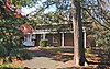 |
January 10, 1983 (#83001450) |
222 Doremus Avenue 40°58′23″N 74°07′37″W / 40.973056°N 74.126944°W |
Part of the Early Stone Houses of Bergen County Multiple Property Submission (MPS) |
| 2 | Ackerman House |  |
January 10, 1983 (#83001451) |
252 Lincoln Avenue 40°58′29″N 74°08′05″W / 40.974722°N 74.134722°W |
Part of the Early Stone Houses of Bergen County MPS |
| 3 | David Ackerman House | 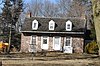 |
January 10, 1983 (#83001448) |
415 E. Saddle River Road 40°59′06″N 74°05′20″W / 40.985°N 74.088889°W |
Part of the Early Stone Houses of Bergen County MPS |
| 4 | Ackerman–Van Emburgh House |  |
January 10, 1983 (#83001456) |
789 East Glen Avenue 40°59′03″N 74°05′19″W / 40.984167°N 74.088611°W |
Part of the Early Stone Houses of Bergen County MPS |
| 5 | Archibald–Vroom House | 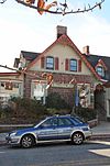 |
July 24, 1984 (#84002596) |
160 E. Ridgewood Avenue 40°58′43″N 74°06′58″W / 40.978611°N 74.116111°W |
Part of the Early Stone Houses of Bergen County MPS |
| 6 | Beech Street School |  |
March 12, 1998 (#98000233) |
49 Cottage Place 40°58′47″N 74°06′53″W / 40.979647°N 74.114825°W |
|
| 7 | Paramus Reformed Church Historic District |  |
February 25, 1975 (#75001121) |
Bounded by Franklin Tpke., NJ 17, Saddle River, S side of cemetery, and Glen Ave. 40°59′09″N 74°05′39″W / 40.985939°N 74.094078°W |
|
| 8 | Rathbone–Zabriskie House | 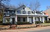 |
January 10, 1983 (#83001545) |
570 N. Maple Avenue 40°59′43″N 74°06′41″W / 40.995278°N 74.111389°W |
Part of the Early Stone Houses of Bergen County MPS |
| 9 | Ridgewood Station |  |
June 22, 1984 (#84002582) |
Garber Sq. 40°58′51″N 74°07′16″W / 40.980833°N 74.121111°W |
|
| 10 | James C. Rose Residence | 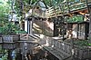 |
July 11, 2019 (#97000936) |
506 E. Ridgewood Avenue 40°58′38″N 74°06′31″W / 40.9773°N 74.1085°W |
Part of the James Rose Center |
| 11 | Van Dien House |  |
January 10, 1983 (#83001567) |
627 Grove St. 40°57′59″N 74°06′03″W / 40.966389°N 74.100833°W |
|
| 12 | Vanderbeck House | 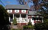 |
January 10, 1983 (#83001564) |
249 Prospect St. 40°58′25″N 74°07′01″W / 40.973611°N 74.116944°W |
|
| 13 | Westervelt–Cameron House |  |
January 10, 1983 (#83001581) |
26 E. Glen Avenue 40°59′21″N 74°06′54″W / 40.989167°N 74.115°W |
Part of the Early Stone Houses of Bergen County MPS |
| 14 | John A. L. Zabriskie House | 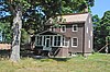 |
November 22, 2019 (#100004648) |
460 W. Saddle River Road 40°59′19″N 74°05′34″W / 40.9885°N 74.0927°W |
Also known as the Zabriskie–Schedler House |
References edit
- ^ The latitude and longitude information provided in this table was derived originally from the National Register Information System, which has been found to be fairly accurate for about 99% of listings. Some locations in this table may have been corrected to current GPS standards.
- ^ National Park Service, United States Department of the Interior, "National Register of Historic Places: Weekly List Actions", retrieved April 12, 2024.
- ^ Numbers represent an alphabetical ordering by significant words. Various colorings, defined here, differentiate National Historic Landmarks and historic districts from other NRHP buildings, structures, sites or objects.
- ^ "National Register Information System". National Register of Historic Places. National Park Service. July 9, 2010.
- ^ The eight-digit number below each date is the number assigned to each location in the National Register Information System database, which can be viewed by clicking the number.