


Summary
Queens is a borough of New York City, coextensive with Queens County, in the U.S. state of New York. Located at the western end of Long Island, it is the largest of the five New York City boroughs by area. It is bordered by the borough of Brooklyn[5] and by Nassau County to its east, and shares maritime borders with the boroughs of Manhattan, the Bronx, and Staten Island, as well as with New Jersey.[6]
Queens
Queens County, New York | |
|---|---|
 Flag  Seal | |
Interactive map outlining Queens.mw-parser-output .locmap .od{position:absolute}.mw-parser-output .locmap .id{position:absolute;line-height:0}.mw-parser-output .locmap .l0{font-size:0;position:absolute}.mw-parser-output .locmap .pv{line-height:110%;position:absolute;text-align:center}.mw-parser-output .locmap .pl{line-height:110%;position:absolute;top:-0.75em;text-align:right}.mw-parser-output .locmap .pr{line-height:110%;position:absolute;top:-0.75em;text-align:left}.mw-parser-output .locmap .pv>div{display:inline;padding:1px}.mw-parser-output .locmap .pl>div{display:inline;padding:1px;float:right}.mw-parser-output .locmap .pr>div{display:inline;padding:1px;float:left}html.skin-theme-clientpref-night .mw-parser-output .od,html.skin-theme-clientpref-night .mw-parser-output .od .pv>div,html.skin-theme-clientpref-night .mw-parser-output .od .pl>div,html.skin-theme-clientpref-night .mw-parser-output .od .pr>div{background:#000;color:#fff}html.skin-theme-clientpref-night .mw-parser-output .locmap{filter:grayscale(0.6)}@media(prefers-color-scheme:dark){html.skin-theme-clientpref-os .mw-parser-output .locmap{filter:grayscale(0.6)}html.skin-theme-clientpref-os .mw-parser-output .od,html.skin-theme-clientpref-os .mw-parser-output .od .pv>div,html.skin-theme-clientpref-os .mw-parser-output .od .pl>div,html.skin-theme-clientpref-os .mw-parser-output .od .pr>div{background:#000;color:#fff}} Queens Location within New York City  Queens Location within the State of New York  Queens Location within the United States  Queens Location on Earth | |
| Coordinates: 40°45′N 73°52′W / 40.750°N 73.867°W | |
| Country | |
| State | |
| County | Queens (coterminous) |
| City | New York City |
| Settled | 1683 |
| Named for | Catherine of Braganza |
| Government | |
| • Type | Borough (New York City) |
| • Borough President | Donovan Richards (D) — (Borough of Queens) |
| • District Attorney | Melinda Katz (D) — (Queens County) |
| Area | |
| • Total | 178 sq mi (460 km2) |
| • Land | 109 sq mi (280 km2) |
| • Water | 70 sq mi (200 km2) 39% |
| Highest elevation | 258.2 ft (78.7 m) |
| Population | |
| • Total | 2,405,464 |
| • Density | 22,124.5/sq mi (8,542.3/km2) |
| Demonym | Queensite[3] |
| GDP | |
| • Total | US$103.325 billion (2022) |
| ZIP Code prefixes | 111--, 113--, 114--, 116-- |
| Area codes | 718/347/929 and 917 |
| Congressional districts | 3rd, 5th, 6th, 7th, 14th |
| Website | Official Website of the Queens Borough President |


With a population of 2,405,464 as of the 2020 census,[2] Queens is the second-most populous county in New York state, behind Kings County (Brooklyn), and is therefore also the second-most populous of the five New York City boroughs. If Queens were its own city, it would be the fourth most-populous in the U.S. after New York City itself, Los Angeles, and Chicago. Queens is the fourth-most densely populated borough in New York City and the fourth-most densely populated U.S. county. About 47% of its residents are foreign-born.[7] Queens is the most linguistically and ethnically diverse place on Earth.[8][9][10]
Queens was established in 1683 as one of the original 12 counties of the Province of New York. The settlement was named after the English Queen and Portuguese royal princess Catherine of Braganza (1638–1705).[11] From 1683 to 1899, the County of Queens included what is now Nassau County. Queens became a borough during the consolidation of New York City in 1898, combining the towns of Long Island City, Newtown, Flushing, Jamaica, and western Hempstead.[12] All except Hempstead are today considered neighborhoods of Queens.
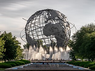
Queens has the most diversified economy of the five boroughs of New York City.[13] It is home to both of New York City's airports: John F. Kennedy and LaGuardia. Among its landmarks are Flushing Meadows–Corona Park; Citi Field, home to the New York Mets baseball team; the USTA Billie Jean King National Tennis Center, site of the U.S. Open tennis tournament; Kaufman Astoria Studios; Silvercup Studios; and the Aqueduct Racetrack. Flushing is undergoing rapid gentrification with investment by Chinese transnational entities,[14] while Long Island City is undergoing gentrification secondary to its proximity across the East River from Manhattan.
History edit
Colonial and post-colonial history edit

The first European settlement in the region was the Dutch, who established the colony of New Netherland. The first settlements were established in 1635 followed by further settlement at Maspeth in 1642 (ultimately unsuccessful),[15] and Vlissingen (now Flushing) in 1645.[16] Other early settlements included Newtown (now Elmhurst) in 1652 and Jamaica in 1655. However, these towns were mostly inhabited by English settlers from New England via eastern Long Island (Suffolk County) who were subject to Dutch law.[17] After the capture of the colony by the English and its subsequent renaming as New York in 1664, the area (and all of Long Island) became known as Yorkshire.[18]: xi–xii
The Flushing Remonstrance signed by colonists in 1657 is considered a precursor to the United States Constitution's provision on freedom of religion in the Bill of Rights. The signers protested the Dutch colonial authorities' persecution of Quakers in what is today the borough of Queens.
Originally, Queens County included the adjacent area now comprising Nassau County. It was an original county of New York State, one of twelve created on November 1, 1683.[18]: 121–122 The county is presumed to have been named after Catherine of Braganza, since she was queen of England at the time (she was Portugal's royal princess Catarina, daughter of King John IV of Portugal).[11] The county was founded alongside Kings County (Brooklyn, which was named after her husband, King Charles II), and Richmond County (Staten Island, named after his illegitimate son, the 1st Duke of Richmond).[19][20][21] However, the namesake is disputed. While Catherine's title seems the most likely namesake, no historical evidence of official declaration has been found.[22] On October 7, 1691, all counties in the Colony of New York were redefined. Queens gained North and South Brother Islands as well as Huletts Island (today known as Rikers Island).[18]: 268 On December 3, 1768, Queens gained other islands in Long Island Sound that were not already assigned to a county but that did not abut on Westchester County (today's Bronx County).[18]: 1062–1063
Queens played a minor role in the American Revolution, as compared to Brooklyn, where the Battle of Long Island was largely fought. Queens, like the rest of what became New York City and Long Island, remained under British occupation after the Battle of Long Island in 1776 and was occupied throughout most of the rest of the Revolutionary War. Under the Quartering Act, British soldiers used, as barracks, the public inns and uninhabited buildings belonging to Queens residents. Even though many residents opposed unannounced quartering, they supported the British crown. The quartering of soldiers in private homes, except in times of war, was banned by the Third Amendment to the United States Constitution. Nathan Hale was captured by the British on the shore of Flushing Bay and hanged in Manhattan.
From 1683 until 1784, Queens County consisted of five towns: Flushing, Hempstead, Jamaica, Newtown, and Oyster Bay. On April 6, 1784, a sixth town, the Town of North Hempstead, was formed through secession by the northern portions of the Town of Hempstead.[23][24] The seat of the county government was located first in Jamaica,[25] but the courthouse was torn down by the British during the American Revolution to use the materials to build barracks.[26] After the war, various buildings in Jamaica temporarily served as courthouse and jail until a new building was erected about 1787 (and later completed) in an area near Mineola (now in Nassau County) known then as Clowesville.[27][28][29]
The 1850 United States census was the first in which the population of the three western towns exceeded that of the three eastern towns that are now part of Nassau County. Concerns were raised about the condition and distance of the old courthouse, and several sites were in contention for the construction of a new one.[30]
In 1870, Long Island City split from the Town of Newtown, incorporating itself as a city, consisting of what had been the village of Astoria and some unincorporated areas within the town of Newtown. Around 1874, the seat of county government was moved to Long Island City from Mineola.[31][32][33][34]
On March 1, 1860, the eastern border between Queens County (later Nassau County) and Suffolk County was redefined with no discernible change.[35] On June 8, 1881, North Brother Island was transferred to New York County.[36] On May 8, 1884, Rikers Island was transferred to New York County.[37]
In 1886, Lloyd's Neck, which was then part of the town of Oyster Bay and had earlier been known as Queens Village, was set off and separated from Queens County and annexed to the town of Huntington in Suffolk County.[38][39][40] On April 16, 1964, South Brother Island was transferred to Bronx County.[41]
Incorporation as borough edit
The New York City borough of Queens was authorized on May 4, 1897, by a vote of the New York State Legislature after an 1894 referendum on consolidation.[42] The eastern 280 square miles (730 km2) of Queens that became Nassau County was partitioned on January 1, 1899.[43] Queens Borough was established on January 1, 1898.[44][45][46]
"The city of Long Island City, the towns of Newtown, Flushing and Jamaica, and that part of the town of Hempstead, in the county of Queens, which is westerly of a straight line drawn through the middle of the channel between Rockaway Beach and Shelter Island, in the county of Queens, to the Atlantic Ocean" was annexed to New York City,[12] dissolving all former municipal governments (Long Island City, the county government, all towns, and all villages) within the new borough.[47] The areas of Queens County that were not part of the consolidation plan,[33][48][49][50][51][52][53] consisting of the towns of North Hempstead and Oyster Bay, and the major remaining portion of the Town of Hempstead, remained part of Queens County until they seceded to form the new Nassau County on January 1, 1899. At this point, the boundaries of Queens County and the Borough of Queens became coterminous. With consolidation, Jamaica once again became the county seat, though county offices now extend to nearby Kew Gardens also.[54]
In 1899, New York City conducted a land survey to determine the exact border of Queens between the Rockaways and Lawrence. This proved difficult because the border was defined as "middle of the channel between Rockaway Beach and Shelter Island" (now called Long Beach Island), and that particular channel had closed up by 1899. The surveyors had to determine where the channel had been when the consolidation law was written in 1894. The surveyors did so in part by speaking with local fishermen and oystermen who knew the area well.[53]
From 1905 to 1908, the Long Island Rail Road in Queens became electrified. Transportation to and from Manhattan, previously by ferry or via bridges in Brooklyn, opened up with the Queensboro Bridge finished in 1909, and with railway tunnels under the East River in 1910. From 1915 onward, much of Queens was connected to the New York City Subway system.[27][55] With the 1915 construction of the Steinway Tunnel carrying the IRT Flushing Line between Queens and Manhattan, and the robust expansion of the use of the automobile, the population of Queens more than doubled in the 1920s, from 469,042 in 1920 to 1,079,129 in 1930.[56]
In later years, Queens was the site of the 1939 New York World's Fair and the 1964 New York World's Fair.[57] LaGuardia Airport, established on a site in northern Queens that had been a seaplane base, opened in 1939, named for mayor Fiorello La Guardia, who pushed for the development of a modern airport in New York City.[58] Idlewild Airport, in southern Queens, opened in 1948 on the site of a former golf course and was renamed John F. Kennedy International Airport in 1963.[59] In one of several notable incidents, TWA Flight 800 took off from the airport on July 17, 1996, and exploded in midair off the coast of Long Island, killing all 230 on board the Boeing 747.[60] American Airlines Flight 587 took off from the latter airport on November 12, 2001, but ended up crashing in Belle Harbor, killing all 260 on board and five people on the ground.[61] In late October 2012, much of Breezy Point was damaged by a massive six-alarm fire caused by Hurricane Sandy, the largest fire of residential homes in FDNY history, destroying 126 homes in an area where every building was damaged by either water, wind or the resulting fires.[62]
Geography edit


Queens is located on the far western portion of geographic Long Island and includes a few smaller islands, most of which are in Jamaica Bay, forming part of the Gateway National Recreation Area, which in turn is one of the National Parks of New York Harbor.[63] According to the United States Census Bureau, Queens County has a total area of 178 square miles (460 km2), of which 109 square miles (280 km2) is land and 70 square miles (180 km2) (39%) is water.[64]
Brooklyn, the only other New York City borough on Long Island, lies just south and west of Queens, with Newtown Creek, an estuary that flows into the East River, forming part of the border. To the west and north is the East River, across which is Manhattan to the west and The Bronx to the north. Nassau County is east of Queens on Long Island. Staten Island is southwest of Brooklyn, and shares only a three-mile-long water border (in the Outer Bay) with Queens. North of Queens are Flushing Bay and the Flushing River, connecting to the East River. The East River opens into Long Island Sound. The midsection of Queens is crossed by the Long Island straddling terminal moraine created by the Wisconsin Glacier. The Rockaway Peninsula, the southernmost part of all of Queens, sits between Jamaica Bay and the Atlantic Ocean, featuring 7 miles (11 km) of beaches.[65][66]
Climate edit
Under the Köppen climate classification, Queens has a humid subtropical climate (Cfa) with partial shielding from the Appalachian Mountains and moderating influences from the Atlantic Ocean. Queens receives precipitation throughout the year, with an average of 44.8 inches (114 cm) per year. In an average year, there will be 44 days with either moderate or heavy rain.[67]
An average winter will have 22 days with some snowfall, of which nine days have at least 1 inch (2.5 cm) of snowfall.[67] Summer is typically hot, humid, and wet. An average year will have 17 days with a high temperature of 90 °F (32 °C) or warmer.[67] In an average year, there are 14 days on which the temperature does not go above 32 °F (0 °C) all day.[67] Spring and autumn can vary from chilly to very warm.
The highest temperature ever recorded at LaGuardia Airport was 107 °F (42 °C) on July 3, 1966.[68][67] The highest temperature ever recorded at John F. Kennedy International Airport was 104 °F (40 °C), also on July 3, 1966.[68][69] LaGuardia Airport's record-low temperature was −7 °F (−22 °C) on February 15, 1943, the effect of which was exacerbated by a shortage of heating oil and coal.[67][70] John F. Kennedy International Airport's record-low temperature was −2 °F (−19 °C), on February 8, 1963, and January 21, 1985.[69][71][72] On January 24, 2016, 30.5 inches (77 cm) of snow fell, which is the record in Queens.[73]
Tornadoes are generally rare; the most recent tornado, an EF0, touched down in College Point on August 3, 2018, causing minor damage.[74] Before that, there was a tornado in Breezy Point on September 8, 2012, which damaged the roofs of some homes,[75] and an EF1 tornado in Flushing on September 26, 2010.[76]
| Climate data for JFK Airport, New York (1991–2020 normals,[a] extremes 1948–present) | |||||||||||||
|---|---|---|---|---|---|---|---|---|---|---|---|---|---|
| Month | Jan | Feb | Mar | Apr | May | Jun | Jul | Aug | Sep | Oct | Nov | Dec | Year |
| Record high °F (°C) | 71 (22) |
71 (22) |
85 (29) |
90 (32) |
99 (37) |
99 (37) |
104 (40) |
101 (38) |
98 (37) |
95 (35) |
80 (27) |
75 (24) |
104 (40) |
| Mean maximum °F (°C) | 57.7 (14.3) |
58.3 (14.6) |
67.5 (19.7) |
77.9 (25.5) |
85.6 (29.8) |
92.4 (33.6) |
95.2 (35.1) |
91.9 (33.3) |
87.9 (31.1) |
79.7 (26.5) |
68.9 (20.5) |
60.6 (15.9) |
96.8 (36.0) |
| Mean daily maximum °F (°C) | 39.5 (4.2) |
41.7 (5.4) |
48.7 (9.3) |
58.8 (14.9) |
68.4 (20.2) |
78.0 (25.6) |
83.6 (28.7) |
82.2 (27.9) |
75.8 (24.3) |
64.7 (18.2) |
53.8 (12.1) |
44.5 (6.9) |
61.6 (16.4) |
| Daily mean °F (°C) | 32.8 (0.4) |
34.5 (1.4) |
41.1 (5.1) |
50.9 (10.5) |
60.5 (15.8) |
70.2 (21.2) |
76.1 (24.5) |
75.0 (23.9) |
68.4 (20.2) |
57.2 (14.0) |
46.8 (8.2) |
38.3 (3.5) |
54.3 (12.4) |
| Mean daily minimum °F (°C) | 26.2 (−3.2) |
27.4 (−2.6) |
33.6 (0.9) |
42.9 (6.1) |
52.5 (11.4) |
62.4 (16.9) |
68.7 (20.4) |
67.8 (19.9) |
61.0 (16.1) |
49.8 (9.9) |
39.8 (4.3) |
32.0 (0.0) |
47.0 (8.3) |
| Mean minimum °F (°C) | 10.2 (−12.1) |
13.3 (−10.4) |
20.2 (−6.6) |
32.6 (0.3) |
42.9 (6.1) |
52.6 (11.4) |
62.8 (17.1) |
60.1 (15.6) |
50.0 (10.0) |
37.9 (3.3) |
26.9 (−2.8) |
18.6 (−7.4) |
8.2 (−13.2) |
| Record low °F (°C) | −2 (−19) |
−2 (−19) |
7 (−14) |
20 (−7) |
34 (1) |
45 (7) |
55 (13) |
46 (8) |
40 (4) |
30 (−1) |
15 (−9) |
2 (−17) |
−2 (−19) |
| Average precipitation inches (mm) | 3.23 (82) |
2.76 (70) |
3.94 (100) |
3.55 (90) |
3.66 (93) |
3.85 (98) |
3.86 (98) |
4.11 (104) |
3.58 (91) |
3.72 (94) |
3.07 (78) |
3.96 (101) |
43.29 (1,100) |
| Average snowfall inches (cm) | 7.5 (19) |
8.6 (22) |
4.3 (11) |
0.6 (1.5) |
0.0 (0.0) |
0.0 (0.0) |
0.0 (0.0) |
0.0 (0.0) |
0.0 (0.0) |
0.0 (0.0) |
0.4 (1.0) |
4.5 (11) |
25.9 (66) |
| Average precipitation days (≥ 0.01 inch) | 10.7 | 9.8 | 10.8 | 11.4 | 11.8 | 10.6 | 9.4 | 9.0 | 8.2 | 9.4 | 8.9 | 11.2 | 121.2 |
| Average snowy days (≥ 0.1 in) | 4.6 | 3.8 | 2.5 | 0.3 | 0.0 | 0.0 | 0.0 | 0.0 | 0.0 | 0.0 | 0.2 | 2.6 | 14.0 |
| Average relative humidity (%) | 64.9 | 64.4 | 63.4 | 64.1 | 69.5 | 71.5 | 71.4 | 71.7 | 71.9 | 69.1 | 67.9 | 66.3 | 68.0 |
| Source: NOAA (relative humidity 1961–1990)[77][78][79] | |||||||||||||
Neighborhoods edit
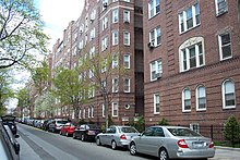

Four United States Postal Service postal zones serve Queens, based roughly on those serving the towns in existence at the consolidation of the five boroughs into New York City: Long Island City (ZIP codes starting with 111), Jamaica (114), Flushing (113), and Far Rockaway (116). Also, the Floral Park post office (110), based in Nassau County, serves a small part of northeastern Queens. Each of these main post offices has neighborhood stations with individual ZIP codes, and unlike the other boroughs, these station names are often used in addressing letters. These ZIP codes do not always reflect traditional neighborhood names and boundaries; "East Elmhurst", for example, was largely coined by the USPS and is not an official community.[citation needed] Most neighborhoods have no solid boundaries. The Forest Hills and Rego Park neighborhoods, for instance, overlap.
Residents of Queens often closely identify with their neighborhood rather than with the borough or city. The borough is a patchwork of dozens of unique neighborhoods, each with its own distinct identity:
- Flushing, one of the largest neighborhoods in Queens, has a large and growing Asian community. The community consists of Chinese, Koreans, and South Asians. Asians have now expanded eastward along the Northern Boulevard axis through Murray Hill, Whitestone, Bayside, Douglaston–Little Neck, and eventually into adjacent Nassau County.[80][81] These neighborhoods historically contained Italian Americans and Greeks, as well as Latino Americans. The busy intersection of Main Street, Kissena Boulevard, and 41st Avenue defines the center of Downtown Flushing and the Flushing Chinatown (法拉盛華埠), known as the "Chinese Times Square" or the "Chinese Manhattan".[82][83] The segment of Main Street between Kissena Boulevard and Roosevelt Avenue, punctuated by the Long Island Rail Road trestle overpass, represents the cultural heart of the Flushing Chinatown. Housing over 25,000 individuals born in China alone, Flushing has become home to one of the largest Chinatowns, representing the largest Chinese population of any U.S. municipality other than New York City in total.[84]
- Howard Beach, Whitestone, and Middle Village are home to large Italian American populations.
- Ozone Park and South Ozone Park have large Italian, Hispanic, and Guyanese populations.
- Rockaway Beach has a large Irish American population.
- Astoria, in the northwest, is traditionally home to one of the largest Greek populations outside Greece. It also has large Spanish American and Italian American communities, and is home to a growing population of immigrants from the Middle East, South Asia, the Balkans as well as young professionals from Manhattan. Nearby Long Island City is a major commercial center and the home to Queensbridge, the largest housing project in North America.
- Maspeth and Ridgewood are home to many Eastern European immigrants such as Romanian, Polish, Serbian, Albanian, and other Slavic populations. Ridgewood also has a large Hispanic population.
- Jackson Heights and Elmhurst make up a conglomeration of Hispanic, Asian, Tibetan, and South Asian communities. Jackson Heights is also known as "Little Colombia" thanks to the gastronomical and demographic impact of Colombian people.[85]
- Woodside is home to a large Filipino American community and has a "Little Manila" as well a large Irish American population. Many Filipino Americans live in Hollis and Queens Village.
- Richmond Hill, in the south, is often thought of as "Little Guyana" for its large Guyanese community,[86] as well as Punjab Avenue (ਪੰਜਾਬ ਐਵੇਨਿਊ), or Little Punjab, for its high concentration of Punjabi people.
- Rego Park, Forest Hills, Kew Gardens, and Kew Gardens Hills have traditionally large Jewish populations (historically from Germany and Eastern Europe; though more recent immigrants are from Israel, Iran, and the former Soviet Union). These neighborhoods are also known for large and growing Asian communities, mainly immigrants from China.
- Jamaica Estates, Jamaica Hills, Hillcrest, Fresh Meadows, and Hollis Hills are also populated with many people of Jewish background. Many Asian families reside in parts of Fresh Meadows as well.
- Jamaica is home to large African American, Caribbean, and Central American populations. There are also middle-class African American and Caribbean neighborhoods such as Saint Albans, Queens Village, Cambria Heights, Springfield Gardens, Rosedale, Laurelton, and Briarwood along east and southeast Queens.
- Bellerose and Floral Park, originally home to many Irish Americans, is home to a growing South Asian population, predominantly Indian Americans.
- Corona and Corona Heights, once considered the "Little Italy" of Queens, was a predominantly Italian community with a strong African American community in the northern portion of Corona and adjacent East Elmhurst. From the 1920s through the 1960s, Corona remained a close-knit neighborhood. Corona today has the highest concentration of Latinos of any Queens neighborhood, with an increasing Chinese American population, located between Elmhurst and Flushing.[87]
Demographics edit
| Jurisdiction | Population | Land area | Density of population | GDP | ||||
|---|---|---|---|---|---|---|---|---|
| Borough | County | Census (2020) |
square miles |
square km |
people/ sq. mile |
people/ sq. km |
billions (2022 US$) 2 | |
Bronx
|
1,472,654 | 42.2 | 109.2 | 34,920 | 13,482 | $43.7 | ||
Kings
|
2,736,074 | 69.4 | 179.7 | 39,438 | 15,227 | $107.3 | ||
New York
|
1,694,251 | 22.7 | 58.7 | 74,781 | 28,872 | $781.0 | ||
Queens
|
2,405,464 | 108.7 | 281.6 | 22,125 | 8,542 | $103.3 | ||
Richmond
|
495,747 | 57.5 | 149.0 | 8,618 | 3,327 | $17.5 | ||
| 8,804,190 | 300.5 | 778.2 | 29,303 | 11,314 | $1,052.8 | |||
| 20,201,249 | 47,123.6 | 122,049.5 | 429 | 166 | $1,763.5 | |||
| Sources:[88][89][90][91] and see individual borough articles. | ||||||||
| Racial composition | 2020[92] | 2010[93] | 1990[94] | 1970[94] | 1950[94] |
|---|---|---|---|---|---|
| White | 25.8% | 39.7% | 57.9% | 85.3% | 96.5% |
| —Non-Hispanic | 22.8% | 27.6% | 48.0% | n/a | n/a |
| Black or African American | 16.8% | 19.1% | 21.7% | 13.0% | 3.3% |
| Hispanic or Latino (of any race) | 27.8% | 27.5% | 19.5% | 7.7%[95] | n/a |
| Asian | 27.5% | 22.9% | 12.2% | 1.1% | 0.1% |
| ||||||||||||||||||||||||||||||||||||||||||||||||||||||||||||||||||||||||||||||||||||||||||||||||||||||||


At the 2020 census, 2,405,464 people lived in Queens. In 2018's American Community Survey, the population of Queens was estimated by the United States Census Bureau to have increased to 2,278,906, a rise of 2.2%. Queens' estimated population represented 27.1% of New York City's population of 8,398,748; 29.6% of Long Island's population of 7,701,172; and 11.7% of New York State's population of 19,542,209. The 2019 estimates reported a decline to 2,253,858.[99] In 2018, there were 865,878 housing units, and 777,904 households, 2.97 persons per household, and a median value of $481,300. There was an owner-occupancy rate of 44.5.[99] In the 2010 United States census, Queens recorded a population of 2,230,722. There were 780,117 households enumerated, with an average of 2.82 persons per household. The population density was 20,465.3 inhabitants per square mile (7,901.7 inhabitants/km2). There were 835,127 housing units at an average density of 7,661.7 units per square mile (2,958.2/km2).
The racial makeup of the county in 2010 was 39.7% White, 19.1% Black or African American, 0.7% Native American, 22.9% Asian, 0.1% Pacific Islander, 12.9% from other races, and 4.5% from two or more races. A total of 27.5% of the population were Hispanic or Latin American of any race. The non-Hispanic white population was 27.6%.[93] In 2019, non-Hispanic whites made up an estimated 24.4% of the population, and Blacks or African Americans were 17.3%.[99] The largest minority groups for the borough were Hispanic and Latin Americans (28.2%), and Asians (26.0%).
In Queens, residents consisted of 6.2% under 5, 13.9% 6–18, 64.2% 19–64, and 15.7% over 65. Females made up 51.5% of the population. An estimated 47.5% of residents are foreign-born in 2018. The per capita income was $28,814, and the median household income was $62,008. In 2018, 12.2% of residents lived below the poverty line.
The New York City Department of City Planning was alarmed by the negligible reported increase in population between 2000 and 2010. Areas with high proportions of immigrants and undocumented aliens are traditionally undercounted for a variety of reasons, often based on a mistrust of government officials or an unwillingness to be identified. In many cases, counts of vacant apartment units did not match data from local surveys and reports from property owners.[100]
As of 2023, illegal Chinese immigration to New York City, especially to Queens and its Flushing Chinatown, has accelerated.[101]
Ethnic groups edit


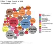
According to a 2001 Claritas study, Queens was the most diverse county in the United States among counties of 100,000+ population.[102] A 2014 analysis by The Atlantic found Queens County to be the third most racially diverse county-equivalent in the United States—behind Aleutians West Census Area and Aleutians East Borough in Alaska—as well as the most diverse county in New York.[9] Meanwhile, a 2017 study by Axios found that, although numerous smaller counties in the United States had higher rates of diversity, Queens was the United States' most diverse populous county.[10]
In Queens, approximately 48.5% of the population was foreign born as of 2010. Within the foreign born population, 49.5% were born in Latin America, 33.5% in Asia, 14.8% in Europe, 1.8% in Africa, and 0.4% in North America. Roughly 2.1% of the population was born in Puerto Rico, a U.S. territory, or abroad to American parents. In addition, 51.2% of the population was born in the United States. Approximately 44.2% of the population over 5 years of age speak English at home; 23.8% speak Spanish at home. Also, 16.8% of the populace speak other Indo-European languages at home. Another 13.5% speak a non-Indo-European Asian language or language of the Pacific Islands at home.[103]
Among the Asian population in 2010, people of Chinese ethnicity made up the largest ethnic group at 10.2% of Queens' population, with about 237,484 people; the other East and Southeast Asian groups are: Koreans (2.9%), Filipinos (1.7%), Japanese (0.3%), Thais (0.2%), Vietnamese (0.2%), and Indonesians and Burmese both make up 0.1% of the population.[104] People of South Asian descent made up 7.8% of Queens' population: Indians (5.3%), Bangladeshi (1.5%), Pakistanis (0.7%), and Nepali (0.2%).[104] In 2019, Chinese Americans remained the largest Asian ethnicity (10.9%) followed by Asian Indians (5.7%).[99] Asian Indians had estimated population of 144,896 in 2014 (6.24% of the 2014 borough population),[105] as well as Pakistani Americans, who numbered at 15,604.[106] Queens has the second largest Sikh population in the nation after California.[107]
Among the Hispanic or Latin American population, Puerto Ricans made up the largest ethnic group at 4.6%, next to Mexicans, who made up 4.2% of the population, and Dominicans at 3.9%. Central Americans made up 2.4% and are mostly Salvadorans. South Americans constitute 9.6% of Queens's population, mainly of Ecuadorian (4.4%) and Colombian descent (4.2%).[104] The 2019 American Community Survey estimated Mexicans and Puerto Ricans were equally the largest groups (4.5% each) in Queens, and Cuban Americans were the third largest single group. Other Hispanic and Latinos collectively made up 18.9% of the population.[99] The Hispanic or Latino population increased by 61% to 597,773 between 1990 and 2006 and now accounts for over 26.5% of the borough's population.
Queens has the largest Colombian population in the city, accounting for over 35.6% of the city's total Colombian population, for a total of 145,956 in 2019;[85] it also has the largest Ecuadorian population in the city, accounting for 62.2% of the city's total Ecuadorian population, for a total of 101,339. Queens has the largest Peruvian population in the city, accounting for 69.9% of the city's total Peruvian population, for a total of 30,825. Queens has the largest Salvadoran population in the city, accounting for 50.7% of the city for a total population of 25,235. The Mexican population in Queens has increased 45.7% since 2011 to 71,283, the second-highest in the city, after Brooklyn.[108]
Queens is also home to 49.6% of the city's Asian population. Among the five boroughs, Queens has the largest population of Chinese, Indian, Korean, Filipino, Bangladeshi and Pakistani Americans. Queens has the largest Asian American population by county outside the Western United States; according to the 2006 American Community Survey, Queens ranks fifth among US counties with 477,772 (21.18%) Asian Americans, behind Los Angeles County, California, Honolulu County, Hawaii, Santa Clara County, California, and Orange County, California.
Some main European ancestries in Queens as of 2000 include: Italian (8.4%), Irish (5.5%), German (3.5%), Polish (2.7%), Russian (2.3%), and Greek (2.0%). Of the European American population, Queens has the third largest Bosnian population in the United States behind only St. Louis and Chicago, numbering more than 15,000.[109] Queens is home to some 50,000 Armenian Americans.[110]
The Jewish Community Study of New York 2011, sponsored by the UJA-Federation of New York, found that about 9% of Queens residents were Jews.[111] In 2011, there were about 198,000 Jews in Queens, making it home to about 13% of all people in Jewish households in the eight-county area consisting of the Five Boroughs and Westchester, Nassau, and Suffolk counties.[111] Russian-speaking Jews make up 28% of the Jewish population in Queens, the largest in any of the eight counties.[112]
In Queens, the Black and African American population earns more than non-Hispanic whites on average.[113] Many of these Blacks and African Americans live in quiet, middle-class suburban neighborhoods near the Nassau County border, such as Laurelton and Cambria Heights, which have large Black populations whose family income is higher than average. The migration of European Americans from parts of Queens has been long ongoing with departures from Ozone Park, Woodhaven, Bellerose, Floral Park, and Flushing (most of the outgoing population has been replaced with Asian Americans). Neighborhoods such as Whitestone, College Point, North Flushing, Auburndale, Bayside, Middle Village, and Douglaston–Little Neck have not had a substantial exodus of white residents, but have seen an increase of Asian population, mostly Chinese and Korean. Queens has experienced a real estate boom making most of its neighborhoods desirable for people who want to reside near Manhattan but in a less urban setting.
Languages edit
According to the office of the New York State Comptroller in 2000, 138 languages are spoken in the borough.[114] The 2021 American Community Survey by the United States Census Bureau, found that – of those over the age of five residing in Queens – 54.53% spoke a language other than English in the home. The following tables shows the 15 most common non-English languages in Queens, with the most prominent being Spanish, Chinese, and Bengali.
| Language |
|---|
| Ages 5+ |
| % |
| Source → |
| 1 | 2 | 3 | 4 | 5 | 6 | 7 | 8 | 9 | 10 | 11 | 12 | 13 | 14 | 15 | 16 | |||||||||||||||
|---|---|---|---|---|---|---|---|---|---|---|---|---|---|---|---|---|---|---|---|---|---|---|---|---|---|---|---|---|---|---|
| English | non-English | Spanish | Chinese | Bengali | Korean | Tagalog | Russian | Haitian | Polish | Italian | Greek | Arabic | Punjabi | Urdu | Hindi | French | ||||||||||||||
| 1,000,116 | 1,199,561 | 516,251 | 205,371 | 84,349 | 41,420 | 30,427 | 28,013 | 24,928 | 22,342 | 21,273 | 19,749 | 16,269 | 16,139 | 15,769 | 13,176 | 12,384 | ||||||||||||||
| 45.47% | 54.53% | 23.47% | 9.34% | 3.83% | 1.88% | 1.38% | 1.27% | 1.13% | 1.02% | 0.97% | 0.9% | 0.74% | 0.73% | 0.72% | 0.6% | 0.56% | ||||||||||||||
| "2021 American Community Survey: LANGUAGE SPOKEN AT HOME"". United States Census Bureau. 2010. Retrieved July 23, 2023. | ||||||||||||||||||||||||||||||
Religion edit

In 2010 statistics, the largest religious group in Queens was the Diocese of Brooklyn, with 677,520 Roman Catholics worshiping at 100 parishes, followed by an estimated 81,456 Muslims with 57 congregations, 80,000 Orthodox Jews with 110 congregations, 33,325 non-denominational Christian adherents with 129 congregations, 28,085 AME Methodists with 14 congregations, 24,250 Greek Orthodox with 6 congregations, 16,775 Hindus with 18 congregations, 13,989 AoG Pentecostals with 64 congregations, 13,507 Seventh-day Adventists with 45 congregations, and 12,957 Mahayana Buddhists with 26 congregations. Altogether, 49.4% of the population was claimed as members by religious congregations, although members of historically African American denominations were underrepresented due to incomplete information.[115] In 2014, Queens had 738 religious organizations, the thirteenth most out of all U.S. counties.[116]
Culture edit


Queens has been the center of the punk rock movement, particularly in New York; Ramones originated out of Forest Hills,[117] it has also been the home of such notable artists as Tony Bennett, Francis Ford Coppola, Paul Simon, and Robert Mapplethorpe.
Queens Poet Laureates (generally, 3-year appointments):
- 1997–2001: Stephen Stepanchev (inaugural Poet Laureate)
- 2001–2004: Hal Sirowitz (born 1949)
- 2004–2007: Ishle Yi Park
- 2007–2010: Julio Marzan
- 2010–2014: Paolo Javier
- 2015–2019: Maria Lisella[118]
Queens has notably fostered African American culture, with establishments such as The Afrikan Poetry Theatre and the Black Spectrum Theater Company catering specifically to African Americans in Queens.[119][120] In the 1940s, Queens was an important center of jazz; such jazz luminaries as Louis Armstrong, Charlie Parker, and Ella Fitzgerald took up residence in Queens, seeking refuge from the segregation they found elsewhere in New York.[121] Additionally, many notable hip-hop acts hail from Queens, including Nas, Run-D.M.C., Kool G Rap, A Tribe Called Quest, LL Cool J, MC Shan, Mobb Deep, 50 Cent, Nicki Minaj, Tony Yayo, Tragedy Khadafi, N.O.R.E., Lloyd Banks, Capone, Ja Rule, Heems of Das Racist and Action Bronson.
Queens hosts various museums and cultural institutions that serve its diverse communities. They range from the historical (such as the John Bowne House) to the scientific (such as the New York Hall of Science), from conventional art galleries (such as the Noguchi Museum) to unique graffiti exhibits (such as 5 Pointz). Queens's cultural institutions include, but are not limited to:
The travel magazine Lonely Planet also named Queens the top destination in the country for 2015 for its cultural and culinary diversity.[122] Stating that Queens is "quickly becoming its hippest" but that "most travelers haven't clued in... yet,"[123] the Lonely Planet stated that "nowhere is the image of New York as the global melting pot truer than Queens."[124]
Food edit
The cuisine available in Queens reflects its vast cultural diversity. The cuisine of a particular neighborhood often represents its demographics; for example, Astoria hosts many Greek restaurants, in keeping with its traditionally Greek population.[125] Jackson Heights is known for its prominent Indian cuisine and also many Latin American eateries.[126]
The Queens Night Market in Flushing Meadows–Corona Park, operating since 2015 on Saturdays from April to October (with a break from late August to mid-September), offers samples of food capped at $6 from dozens of countries with attendance of up to 20,000 a night.[127][128][129]
Economy edit
Queens has the second-largest economy of New York City's five boroughs, following Manhattan. In 2004, Queens had 15.2% (440,310) of all private-sector jobs in New York City and 8.8% of private-sector wages. In 2012, private-sector employment increased to 486,160.[130] Queens has the most diversified economy of the five boroughs, with occupations spread relatively evenly across the health care, retail trade, manufacturing, construction, transportation, and film and television production sectors, such that no single sector is overwhelmingly dominant.[13]
The diversification in Queens' economy is reflected in a large amount of employment in the export-oriented portions of its economy—such as transportation, manufacturing, and business services—that serve customers outside the region. This accounts for more than 27% of all Queens jobs and offers an average salary of $43,727, 14% greater than that of jobs in the locally oriented sector.

The borough's largest employment sector—trade, transportation, and utilities—accounted for nearly 30% of all jobs in 2004; in 2012, its largest employment sector became health care and social services.[130] Queens is home to two of the three major New York City area airports, JFK International Airport and LaGuardia Airport. These airports are among the busiest in the world, leading the airspace above Queens to be the most congested in the country. This airline industry is particularly important to the economy of Queens, providing almost one-quarter of the sector's employment and more than 30% of the sector's wages.
Education and health services were the next largest sector in Queens and comprised almost 24% of the borough's jobs in 2004; in 2012, transportation and warehousing, and retail were the second largest at 12% each.[130] The manufacturing and construction industries in Queens are among the largest of the city and accounted for nearly 17% of the borough's private sector jobs in 2004. Comprising almost 17% of the jobs in Queens is the information, financial activities, and business and professional services sectors in 2004.
As of 2003[update], Queens had almost 40,000 business establishments. Small businesses act as an important part of the borough's economic vitality with two-thirds of all businesses employing between one and four people.
Several large companies have their headquarters in Queens, including watchmaker Bulova, based in East Elmhurst; internationally renowned piano manufacturer Steinway & Sons in Astoria; Glacéau, the makers of Vitamin Water, headquartered in Whitestone; and JetBlue Airways, an airline based in Long Island City.
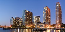
Long Island City is a major manufacturing and back-office center. Flushing is a major commercial hub for Chinese American and Korean American businesses, while Jamaica is the major civic and transportation hub for the borough.
Sports edit
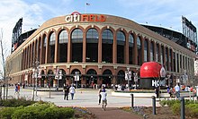

Queens is home of the New York Mets of Major League Baseball.[132] Founded in 1962 as an expansion team, the Mets have won 2 World Series championships and 5 National League pennants. Citi Field is a 41,922-seat stadium opened in April 2009 in Flushing Meadows–Corona Park that is the home ballpark of the Mets.[133] Shea Stadium, the former home of the Mets and the New York Jets of the National Football League, as well as the temporary home of the New York Yankees and the New York Giants Football Team stood where Citi Field's parking lot is now located, operating from 1964 to 2008.[134] Queens is the future home of the new stadium for New York City FC of Major League Soccer, which is expected to be completed in 2027.[135]
The U.S. Open tennis tournament has been played since 1978 at the USTA Billie Jean King National Tennis Center, located just south of Citi Field.[136] With a capacity of 23,771, Arthur Ashe Stadium is the biggest tennis stadium in the world.[137] The U.S. Open was formerly played at the West Side Tennis Club in Forest Hills.[138] South Ozone Park is the home of Aqueduct Racetrack, which is operated by the New York Racing Association, and offers Thoroughbred horse racing from late October/early November through April.[139] (The Belmont Park racetrack and the adjacent UBS Arena (home of the New York Islanders of the National Hockey League) sit entirely in Nassau County, just over the City line; however, small sections of the properties of both venues are in Queens, as is the Belmont Park station of the Long Island Rail Road.)
Government edit
| Year | Republican | Democratic | Third party | |||
|---|---|---|---|---|---|---|
| No. | % | No. | % | No. | % | |
| 2020 | 212,665 | 26.92% | 569,038 | 72.03% | 8,278 | 1.05% |
| 2016 | 149,341 | 21.76% | 517,220 | 75.35% | 19,832 | 2.89% |
| 2012 | 118,589 | 19.92% | 470,732 | 79.08% | 5,924 | 1.00% |
| 2008 | 155,221 | 24.25% | 480,692 | 75.09% | 4,224 | 0.66% |
| 2004 | 165,954 | 27.41% | 433,835 | 71.66% | 5,603 | 0.93% |
| 2000 | 122,052 | 21.95% | 416,967 | 75.00% | 16,972 | 3.05% |
| 1996 | 107,650 | 21.05% | 372,925 | 72.94% | 30,721 | 6.01% |
| 1992 | 157,561 | 28.34% | 349,520 | 62.87% | 48,875 | 8.79% |
| 1988 | 217,049 | 39.70% | 325,147 | 59.47% | 4,533 | 0.83% |
| 1984 | 285,477 | 46.38% | 328,379 | 53.34% | 1,722 | 0.28% |
| 1980 | 251,333 | 44.81% | 269,147 | 47.98% | 40,443 | 7.21% |
| 1976 | 244,396 | 38.95% | 379,907 | 60.54% | 3,200 | 0.51% |
| 1972 | 426,015 | 56.34% | 328,316 | 43.42% | 1,756 | 0.23% |
| 1968 | 306,620 | 40.03% | 410,546 | 53.60% | 48,746 | 6.36% |
| 1964 | 274,351 | 33.59% | 541,418 | 66.28% | 1,059 | 0.13% |
| 1960 | 367,688 | 45.07% | 446,348 | 54.71% | 1,863 | 0.23% |
| 1956 | 471,223 | 59.86% | 315,898 | 40.13% | 144 | 0.02% |
| 1952 | 450,610 | 57.11% | 331,217 | 41.98% | 7,194 | 0.91% |
| 1948 | 323,459 | 50.58% | 268,742 | 42.02% | 47,342 | 7.40% |
| 1944 | 365,365 | 55.33% | 292,940 | 44.36% | 2,071 | 0.31% |
| 1940 | 323,406 | 52.68% | 288,024 | 46.91% | 2,524 | 0.41% |
| 1936 | 162,797 | 33.02% | 320,053 | 64.92% | 10,159 | 2.06% |
| 1932 | 136,641 | 34.32% | 244,740 | 61.47% | 16,760 | 4.21% |
| 1928 | 158,505 | 45.87% | 184,640 | 53.43% | 2,411 | 0.70% |
| 1924 | 100,793 | 53.57% | 58,402 | 31.04% | 28,974 | 15.40% |
| 1920 | 94,360 | 68.71% | 35,296 | 25.70% | 7,668 | 5.58% |
| 1916 | 34,670 | 50.54% | 31,350 | 45.70% | 2,575 | 3.75% |
| 1912 | 9,201 | 16.49% | 28,076 | 50.32% | 18,521 | 33.19% |
| 1908 | 19,420 | 44.13% | 20,342 | 46.22% | 4,246 | 9.65% |
| 1904 | 14,096 | 41.44% | 18,151 | 53.36% | 1,770 | 5.20% |
| 1900 | 12,323 | 43.94% | 14,747 | 52.58% | 976 | 3.48% |
| 1896 | 18,694 | 58.03% | 11,980 | 37.19% | 1,539 | 4.78% |
| 1892 | 11,704 | 41.71% | 15,195 | 54.15% | 1,161 | 4.14% |
| 1888 | 11,017 | 45.95% | 12,683 | 52.90% | 275 | 1.15% |
| 1884 | 8,445 | 43.80% | 10,367 | 53.76% | 471 | 2.44% |
| 1880 | 8,151 | 43.73% | 10,391 | 55.74% | 99 | 0.53% |
| 1876 | 6,970 | 40.99% | 9,994 | 58.77% | 41 | 0.24% |
| 1872 | 6,083 | 51.74% | 5,655 | 48.10% | 19 | 0.16% |
| 1868 | 4,973 | 43.77% | 6,388 | 56.23% | 0 | 0.00% |
| 1864 | 4,284 | 44.24% | 5,400 | 55.76% | 0 | 0.00% |
| 1860 | 3,749 | 46.05% | 4,392 | 53.95% | 0 | 0.00% |
| 1856 | 1,886 | 27.73% | 2,394 | 35.20% | 2,521 | 37.07% |
| 1852 | 2,209 | 43.06% | 2,904 | 56.61% | 17 | 0.33% |
| 1848 | 2,444 | 53.66% | 1,310 | 28.76% | 801 | 17.59% |
| 1844 | 2,547 | 48.07% | 2,751 | 51.93% | 0 | 0.00% |
| 1840 | 2,522 | 49.70% | 2,550 | 50.26% | 2 | 0.04% |
| 1836 | 1,399 | 45.82% | 1,654 | 54.18% | 0 | 0.00% |
| 1832 | 1,400 | 45.83% | 1,655 | 54.17% | 0 | 0.00% |
| 1828 | 1,379 | 54.98% | 1,129 | 45.02% | 0 | 0.00% |
| Party | 2005 | 2004 | 2003 | 2002 | 2001 | 2000 | 1999 | 1998 | 1997 | 1996 |
|---|---|---|---|---|---|---|---|---|---|---|
| Democratic | 62.94% | 62.52 | 62.85 | 62.79 | 62.99 | 62.52 | 62.30 | 62.27 | 62.28 | 62.33 |
| Republican | 14.60% | 14.66 | 14.97 | 15.04 | 15.28 | 15.69 | 16.47 | 16.74 | 16.93 | 17.20 |
| Other | 3.88% | 3.93 | 3.94 | 3.86 | 3.37 | 3.30 | 3.10 | 3.20 | 3.02 | 2.78 |
| No affiliation | 18.58% | 18.89 | 18.24 | 18.31 | 18.36 | 18.49 | 18.13 | 17.79 | 17.77 | 17.69 |

Since New York City's consolidation in 1898, Queens has been governed by the New York City Charter that provides for a strong mayor–council system. The centralized New York City government is responsible for public education, correctional institutions, public safety, recreational facilities, sanitation, water supply, and welfare services in Queens. The Queens Library is governed by a 19-member Board of Trustees, appointed by the Mayor of New York City and the Borough President of Queens.
Since 1990 the Borough President has acted as an advocate for the borough at the mayoral agencies, the City Council, the New York state government, and corporations. Queens' Borough President is Donovan Richards, elected in November 2020 as a Democrat. Queens Borough Hall is the seat of government and is located in Kew Gardens.
The Democratic Party holds most public offices. Sixty-three percent of registered Queens voters are Democrats. Local party platforms center on affordable housing, education, and economic development. Controversial political issues in Queens include development, noise, and the cost of housing.
Each of the city's five counties has its criminal court system and District Attorney, the chief public prosecutor who is directly elected by popular vote. Richard A. Brown, who ran on both the Republican and Democratic Party tickets, was the District Attorney of Queens County from 1991 to 2018. The new DA as of January 2020 is Melinda Katz.[144] Queens has 12 seats on the New York City Council, the second-largest number among the five boroughs. It is divided into 14 community districts, each served by a local Community Board. Community Boards are representative bodies that field complaints and serve as advocates for residents.
Although Queens is heavily Democratic, it is considered a swing county in New York politics. Republican political candidates who do well in Queens usually win citywide or statewide elections. Republicans such as former Mayors Rudolph Giuliani and Michael Bloomberg won majorities in Queens. Republican State Senator Serphin Maltese represented a district in central and southern Queens for twenty years until his defeat in 2008 by Democratic City Councilman Joseph Addabbo, Jr. In 2002, Queens voted against incumbent Republican Governor of New York George Pataki in favor of his Democratic opponent, Carl McCall by a slim margin.[145]
On the national level, Queens has not voted for a Republican candidate in a presidential election since 1972, when Queens voters chose Richard Nixon over George McGovern. Since the 1996 presidential election, Democratic presidential candidates have received over 70% of the popular vote in Queens.[146] Since the election of Donald Trump, Queens has become known in the United States for its surge in progressive politics and grassroots campaigning.[147]
Federal representation edit
As of 2024, five Democrats represent Queens in the United States House of Representatives.[148]
- Tom Suozzi (first elected in 2024) represents New York's 3rd congressional district[149]), which covers the northeast Queens neighborhoods of Little Neck, Whitestone, Glen Oaks, Queens Village and Floral Park. The district also covers the North Shore of Nassau County.[148]
- Gregory Meeks (first elected in 1998) represents New York's 5th congressional district, which covers the entire Rockaway Peninsula as well as the southeast Queens neighborhoods of Broad Channel, Cambria Heights, Hollis, Jamaica, Laurelton, Rosedale, Saint Albans, Springfield Gardens, and South Ozone Park. The district also includes John F. Kennedy International Airport.[148]
- Grace Meng (first elected in 2012) represents New York's 6th congressional district, which includes the central and eastern Queens neighborhoods of Auburndale, Bayside, Elmhurst, Flushing, Forest Hills, Glendale, Kew Gardens, Maspeth, Middle Village, Murray Hill, and Rego Park.[148]
- Nydia Velázquez (first elected in 1992) represents New York's 7th congressional district, which includes the Queens neighborhoods of Maspeth, Ridgewood, Woodhaven, Sunnyside and Long Island City. The district also covers central and western Brooklyn.[148]
- Alexandria Ocasio-Cortez (first elected in 2018) represents New York's 14th congressional district, which includes the northwest Queens neighborhoods of Astoria, College Point, Corona, East Elmhurst, Jackson Heights, Woodside, and Elmhurst. The district also covers the East Bronx.[148]
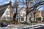
Housing edit

The borough's diverse housing ranges from high-rise apartment buildings in some areas of western and central Queens, such as Forest Hills, Jackson Heights, Flushing, Astoria, and Long Island City; to lower-rise neighborhoods in the eastern part of the borough.[150][151] There were 911,957 housing units in 2022[152] at an average density of 8,388 units per square mile (3,239/km2). Affordable rental and co-operative housing units throughout the borough were created under the Mitchell–Lama Housing Program.[153] Public housing is administered by the New York City Housing Authority, which accounts for more than 30,000 residents in more than 15,300 units in 2023.[154]
Education edit
Elementary and secondary education edit
Elementary and secondary school education in Queens is provided by a vast number of public and private institutions. Non-charter public schools in the borough are managed by the New York City Department of Education,[155] the largest public school system in the United States. Most private schools are affiliated with or identify themselves with the Roman Catholic or Jewish religious communities. Townsend Harris High School is a Queens public magnet high school for the humanities consistently ranked as among the top 100 high schools in the United States. One of the nine Specialized High Schools in New York City is located in Queens. Located in the York College, City University of New York Campus in Jamaica, the Queens High School for the Sciences at York College, which emphasizes both science and mathematics, ranks as one of the best high schools in both the state and the country. It is one of the smallest Specialized High Schools that requires an entrance exam, the Specialized High Schools Admissions Test. The school has a student body of around 400 students.
Postsecondary institutions edit


- LaGuardia Community College, part of the City University of New York (CUNY), is known as "The World's Community College" for its diverse international student body representing more than 150 countries and speaking over 100 languages. The college has been named a National Institution of Excellence by the Policy Center on the First Year of College. In a 2003 benchmark survey, in the Large Community College category (8,000–14,999 students), LaGuardia was one of three community colleges ranked number one, nationally.[156] The college hosts the LaGuardia and Wagner Archives.
- Queens College is one of the elite colleges in the CUNY system. Established in 1937 to offer a strong liberal arts education to the residents of the borough, Queens College has over 16,000 students including more than 12,000 undergraduates and over 4,000 graduate students. Students from 120 countries speaking 66 different languages are enrolled at the school, which is located in Flushing. Queens College is also the host of CUNY's law school. The Queens College Campus is also the home of Townsend Harris High School and the Queens College School for Math, Science, and Technology (PS/IS 499).
- Queensborough Community College, originally part of the State University of New York, is in Bayside and is now part of CUNY. It prepares students to attend senior colleges mainly in the CUNY system.
- St. John's University is a private, coeducational Roman Catholic university founded in 1870 by the Vincentian Fathers. With over 19,000 students, St. John's is known for its pharmacy, business and law programs as well as its men's basketball and soccer teams.
- Vaughn College of Aeronautics and Technology is a private, cutting edge, degree-granting institution located across the Grand Central Parkway from LaGuardia Airport. Its presence underscores the importance of aviation to the Queens economy.
- York College is one of CUNY's leading general-purpose liberal arts colleges, granting bachelor's degrees in more than 40 fields, as well as a combined BS/MS degree in Occupational Therapy. Noted for its Health Sciences Programs York College is also home to the Northeast Regional Office of the Food and Drug Administration.
Queens Public Library edit

The Queens Public Library is the public library system for the borough and one of three library systems serving New York City. Dating back to the foundation of the first Queens library in Flushing in 1858, the Queens Public Library is one of the largest public library systems in the United States. Separate from the New York Public Library, it is composed of 63 branches throughout the borough. In the fiscal year 2001, the Library achieved a circulation of 16.8 million. The Library has maintained the highest circulation of any city library in the country since 1985 and the highest circulation of any library in the nation since 1987. The Library maintains collections in many languages, including Spanish, Chinese, Korean, Russian, Haitian Creole, Polish, and six Indic languages, as well as smaller collections in 19 other languages.
Transportation edit
According to 2011–2015 ACS microdata, 38% of Queens households did not own a car; the citywide rate is 55%.[157]
Vehicles for hire edit
As of 2019, the city had about 80,000 for-hire vehicles, of which, two-thirds were ride-hail – Uber, Lyft, Via, and Juno.[158] Until the COVID-19 pandemic, the ride-hail car offered a ride-share option. There are about 13,500 traditional taxis (yellow cabs with medallions) in the city, 7,676 boro taxis, 38,791 black cars, 21,932 livery cars, 288 commuter vans, and 2,206 paratransit vehicles.
Roundtrip car sharing edit
Zipcar, and others, entered New York City market in 2002 offering roundtrip car sharing from private locations, mostly from parking garages. In 2018, the city partnered with the roundtrip car share companies, led by Zipcar, to launch the nation's larges on-street car-sharing program with the greatest take-up in The Bronx and in Queens – Jackson Heights, Jamaica, and Far Rockaway.[159][160][161][162][163] In 2020, during beginning throes of the COVID-19 pandemic, Enterprise CarShare suspended service in New York City. Among the traditional car rental locations in Queens, both international airports harbor larger fleets, conveniently close to Queens residents.
Micromobility edit
Citi Bike – a docked-bike and e-bike sharing company had, as of July 2019, 169,000 annual subscribers. In 2021, the Department of Transportation and Citi Bike announced that, as part of its Phase 3 expansion, it was doubling its service area to 70 square miles and tripling the number of bikes to 40,000. The expansion includes 52 new docking stations in Astoria, as well as new stations in Sunnyside and Woodside.[164]
Non-docked e-moped service was launched in the city by Revel in 2019. Companies such as Bird, Lime, VeoRide introduced non-docked e-scooter-sharing in 2021.[165]
Airports edit

| Airline Revenue Passengers at Queens Airports 2019 → pre-COVID-19 pandemic | ||||
|
|
Domestic
|
International
|
Rank*
|
Total
|
| JFK | 28,233,791 | 34,317,281 | ❶ | 62,551,072 |
| LGA
|
28,875,041
|
2,209,853
|
|
31,084,894
|
Total
|
57,108,832 | 36,527,134 | 93,635,966 | |
| 2020 → mid-COVID-19 pandemic
| ||||
| JFK | 8,267,666 | 8,362,976 | ❶ | 16,630,642 |
| LGA
|
7,853,368
|
391,824
|
|
8,245,192
|
Total
|
16,121,034 | 8,754,800 | 24,875,834 | |
*National rank for international passengers (enplanements + deplanements)[167][168]
| ||||
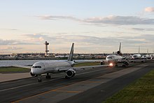
Queens has crucial importance in international and interstate air traffic, with two of the New York metropolitan area's three major airports located there. John F. Kennedy International Airport (JFK), in 2019, before the COVID-19 pandemic, served 62.6 million passengers (enplanements + deplanements) – 34.3 million of which were international, ranking it the busiest airport in the United States by international passenger traffic. In response to the COVID-19 pandemic, the United States imposed travel restrictions, first, in January 2020, on travelers from China and, in the following months, on travelers from other countries. 2020 annual passenger traffic at JFK dropped to 16.6 million (−73.4%) – 8.4 million (−73.4%) of which were international, still ranking it the busiest airport in the United States by international passenger traffic.[167][168]
JFK is owned by the City of New York and managed, since 1947, by the Port Authority of New York and New Jersey. The airport's runways and six terminals cover an area of 4,930 acres (2,000 ha) on Jamaica Bay in southeastern Queens.[169] The airport's original official name was New York International Airport, although it was commonly known as Idlewild, with the name changed to Kennedy in December 1963 to honor the assassination of John F. Kennedy, November 22, 1963.[170]
LaGuardia Airport is located in East Elmhurst, in northern Queens, on Flushing Bay. Originally opened in 1939, the airport's two runways and four terminals cover 680 acres (280 ha), serving 28.4 million passengers in 2015.[171] In 2014, citing outdated conditions in the airport's terminals, Vice President Joe Biden compared LaGuardia Airport to a "third world country".[172] In 2015, the Port Authority of New York and New Jersey began a $4 billion project to renovate LaGuardia Airport's terminals and entryways. The project is expected to be complete by 2021.[166]
Public transportation edit


Subways edit
Queens is served by the New York City Subway, with 81 stations located within the borough.[173] Two physical lines — the IRT Flushing Line and the IND Queens Boulevard Line — serve as the primary east-west trunk lines in the borough, with all services on the two lines continuing across the East River into Manhattan. Two additional lines are wholly within Queens: the BMT Astoria Line, which serves the neighborhoods of Astoria and Ditmars–Steinway, and the IND Rockaway Line, which provides access to John F. Kennedy International Airport and the Rockaways. In addition, five other New York City Subway lines — the BMT Jamaica Line, BMT Myrtle Avenue Line, BMT/IND Archer Avenue Line, IND Crosstown Line, and IND Fulton Street Line — run between Brooklyn and Queens.
The A, G, J/Z, and M routes connect Queens to Brooklyn without going through Manhattan first. The F, N, and R trains connect Queens and Brooklyn via Manhattan, while the E, W, and 7/<7> trains connect Queens to Manhattan only. The L train briefly enters Queens at Halsey Street, connecting Queens to either Brooklyn or both Brooklyn and Manhattan, depending on the direction.[173] In addition, the Rockaway Park Shuttle operates strictly in the neighborhoods of Rockaway Park and Broad Channel.[173]
Long Island Rail Road edit
The Long Island Rail Road, also part of the MTA, operates 24 hours a day, 7 days a week, including holidays – carrying an average of 301,000 customers a day (80 million a year, adjusting downward for weekends) on about 735 scheduled trains.[174] It is the busiest commuter rail hub in the United States. Most of its branches originate or terminate at Penn Station. All but one of its branches (the Port Washington Branch) pass through Jamaica. The New York City area served by the LIRR is called the City Terminal Zone. Within that zone, Queens has stations in Long Island City, Hunterspoint Avenue (in Long Island City), Bayside, Forest Hills, Flushing, Woodside, and Kew Gardens – 22 Queens stations, in all. There are also several stations where LIRR passengers can transfer to the subway.
Sunnyside Yard is used to store Amtrak intercity and NJ Transit commuter trains from Penn Station in Manhattan. The US$11.1 billion East Side Access project, which will bring LIRR trains to Grand Central Terminal in Manhattan, opened in 2023; this project created a new train tunnel beneath the East River, connecting Long Island City in Queens with the East Side of Manhattan.[175][176]
JFK AirTrain edit
The elevated AirTrain people mover system connects JFK International Airport to the New York City Subway and the Long Island Rail Road along the Van Wyck Expressway;[177] a separate AirTrain system is planned alongside the Grand Central Parkway to connect LaGuardia Airport to these transit systems.[178][179] Plans were announced in July 2015 to entirely rebuild LaGuardia Airport itself in a multibillion-dollar project to replace its aging facilities, and this project would accommodate the new AirTrain connection.[166]
MTA buses edit
2019 bus ridership, citywide, on the MTA system, was 2.2 million per average weekday – about 678 million for the year. In Queens, the Q58 and Q44 Select Bus Service were the seventh and tenth, respectively, citywide, busiest local lines in 2019.[180] In addition to regular bus lines serving LaGuardia Airport, the MTA offers two Select Bus Services, regular fare, 24 hours a day, 7 days a week. The M60 – terminals A, B, C, D – to and from Manhattan via Grand Central Parkway and the Triborough Bridge – in Harlem, along 125th Street (with a stop at the 125th Street Metro-North station), ending in Morningside Heights on the Upper West Side, a few blocks south of Columbia University. The Q70 – terminals B, C, D – through Queens, ending in Woodside at 61st Street and Roosevelt Avenue. Overall, about 100 local bus routes operate within Queens, and another 20 express routes shuttle commuters between Queens and Manhattan, under the MTA New York City Bus and MTA Bus brands.[181]
Proposed streetcar edit
A streetcar line connecting Queens with Brooklyn was proposed by the city in February 2016.[182][183] The planned timeline originally called for service to begin around 2024.[184] In September 2020, Mayor de Blasio deferred decisions on the project to after the 2021 New York City mayoral election.[185]
Water transit edit

New York Water Taxi operates service across the East River from Hunters Point in Long Island City to Manhattan at 34th Street and south to Pier 11 at Wall Street. In 2007, limited weekday service was begun between Breezy Point, the westernmost point in the Rockaways, to Pier 11 via the Brooklyn Army Terminal. Summertime weekend service provides service from Lower Manhattan and southwest Brooklyn to the peninsula's Gateway beaches.
In the aftermath of Hurricane Sandy on October 29, 2012, ferry operator SeaStreak began running a city-subsidized ferry service between a makeshift ferry slip at Beach 108th Street and Beach Channel Drive in Rockaway Park and piers in Manhattan and Brooklyn.[186] The service was extended multiple times.[187] finally ending on October 31, 2014.[188]
In February 2015, Mayor Bill de Blasio announced that the city government would begin a citywide ferry service called NYC Ferry to extend ferry transportation to communities in the city that have been traditionally underserved by public transit.[189][190] The ferry opened in May 2017,[191][192] with the Queens neighborhoods of Rockaway and Astoria served by their eponymous routes. A third route, the East River Ferry, serves Hunter's Point South.[193]
Roads edit
Highways edit

Queens is traversed by three trunk east–west highways. The Long Island Expressway (Interstate 495) runs from the Queens Midtown Tunnel on the west through the borough to Nassau County on the east. The Grand Central Parkway, whose western terminus is the Triborough Bridge, extends east to the Queens/Nassau border, where the roadway continues as the Northern State Parkway. The Belt Parkway begins at the Gowanus Expressway in Brooklyn, and extends east into Queens, past Aqueduct Racetrack and JFK Airport. On its eastern end at the Queens/Nassau border, it splits into the Southern State Parkway which continues east, and the Cross Island Parkway which turns north.[194]
There are also several major north–south highways in Queens, including the Brooklyn-Queens Expressway (Interstate 278), the Van Wyck Expressway (Interstate 678), the Clearview Expressway (Interstate 295), and the Cross Island Parkway.[194]
Queens has six state highways that run west–east largely on surface roads. From north to south, they are New York State Route 25A (Northern Boulevard), New York State Route 25B (Hillside Avenue), New York State Route 25 (Queens Boulevard, Hillside Avenue, and Braddock Avenue), New York State Route 24 (Hempstead Avenue), and New York State Route 27 (Conduit Avenue). The only state highway that primarily uses an expressway is New York State Route 878, which uses the Nassau Expressway in southern Queens.[194]
Streets edit
The streets of Queens are laid out in a semi-grid system, with a numerical system of street names (similar to Manhattan and the Bronx). Nearly all roadways oriented north–south are "Streets", while east–west roadways are "Avenues", beginning with the number 1 in the west for Streets and the north for Avenues. In some parts of the borough, several consecutive streets may share numbers (for instance, 72nd Street followed by 72nd Place and 72nd Lane, or 52nd Avenue followed by 52nd Road, 52nd Drive, and 52nd Court), often confusing non-residents.[195] Also, incongruous alignments of street grids, unusual street paths due to geography, or other circumstances often lead to the skipping of numbers (for instance, on Ditmars Boulevard, 70th Street is followed by Hazen Street which is followed by 49th Street). Numbered roads tend to be residential, although numbered commercial streets are not rare. A fair number of streets that were country roads in the 18th and 19th centuries (especially major thoroughfares such as Northern Boulevard, Queens Boulevard, Hillside Avenue, and Jamaica Avenue) carry names rather than numbers, typically though not uniformly called "Boulevards" or "Parkways".
Queens house numbering was designed to provide convenience in locating the address itself; the first half of a number in a Queens address refers to the nearest cross street, the second half refers to the house or lot number from where the street begins from that cross street, followed by the name of the street itself. For example, to find an address in Queens, 14-01 120th Street, one could ascertain from the address structure itself that the listed address is at the intersection of 14th Avenue and 120th Street and that the address must be closest to 14th Avenue rather than 15th Avenue, as it is the first lot on the block. This pattern does not stop when a street is named, assuming that there is an existing numbered cross-street. For example, Queens College is situated at 65–30 Kissena Boulevard, and is so named because the cross-street closest to the entrance is 65th Avenue.[195]
Many of the village street grids of Queens had only worded names, some were numbered according to local numbering schemes, and some had a mix of words and numbers. In the early 1920s, a "Philadelphia Plan" was instituted to overlay one numbered system upon the whole borough. The Topographical Bureau, Borough of Queens, worked out the details. Subway stations were only partly renamed, and some, including those along the IRT Flushing Line (7 and <7> trains), now share dual names after the original street names.[196] In 2012, some numbered streets in the Douglaston Hill Historic District were renamed to their original names, with 43rd Avenue becoming Pine Street.[197]
The Rockaway Peninsula does not follow the same system as the rest of the borough and has its own numbering system. Streets are numbered in ascending order heading west from near the Nassau County border, and are prefixed with the word "Beach." Streets at the easternmost end, however, are nearly all named. Bayswater, which is on Jamaica Bay, has its numbered streets prefixed with the word "Bay" rather than "Beach". Another deviation from the norm is Broad Channel; it maintains the north–south numbering progression but uses only the suffix "Road", as well as the prefixes "West" and "East", depending on location relative to Cross Bay Boulevard, the neighborhood's major through street. Broad Channel's streets were a continuation of the mainland Queens grid in the 1950s; formerly the highest-numbered avenue in Queens was 208th Avenue rather than today's 165th Avenue in Howard Beach & Hamilton Beach. The other exception is the neighborhood of Ridgewood, which for the most part shares a grid and house numbering system with the Brooklyn neighborhood of Bushwick. The grid runs east–west from the LIRR Bay Ridge Branch right-of-way to Flushing Avenue; and north–south from Forest Avenue in Ridgewood to Bushwick Avenue in Brooklyn before adjusting to meet up with the Bedford-Stuyvesant grid at Broadway. All streets on the grid have names.
Bridges and tunnels edit

Queens is connected to the Bronx by the Bronx–Whitestone Bridge, the Throgs Neck Bridge, the Triborough Bridge (also known as the Robert F. Kennedy Bridge), and the Hell Gate Bridge. Queens is connected to Manhattan Island by the Triborough Bridge, the Queensboro Bridge, and the Queens–Midtown Tunnel, as well as to Roosevelt Island by the Roosevelt Island Bridge.
While most of the Queens/Brooklyn border is on land, the Kosciuszko Bridge crosses the Newtown Creek connecting Maspeth to Greenpoint, Brooklyn. The Pulaski Bridge connects McGuinness Boulevard in Greenpoint to 11th Street, Jackson Avenue, and Hunters Point Avenue in Long Island City. The J. J. Byrne Memorial Bridge (a.k.a. Greenpoint Avenue Bridge) connects the sections of Greenpoint Avenue in Greenpoint and Long Island City. A lesser bridge connects Grand Avenue in Queens to Grand Street in Brooklyn.
The Cross Bay Veterans Memorial Bridge, built in 1939, traverses Jamaica Bay to connect the Rockaway Peninsula to Broad Channel and the rest of Queens.[198] Constructed in 1937, the Marine Parkway–Gil Hodges Memorial Bridge links Flatbush Avenue, Brooklyn's longest thoroughfare, with Jacob Riis Park and the western end of the Peninsula.[199] Both crossings were built and continue to be operated by what is now known as MTA Bridges and Tunnels. The IND Rockaway Line parallels the Cross Bay, has a mid-bay station at Broad Channel which is just a short walk from the Jamaica Bay Wildlife Refuge, now part of Gateway National Recreation Area and a major stop on the Atlantic Flyway.
Notable people edit
Many public figures have grown up or lived in Queens.[200] Donald Trump, a businessman who became the 45th President of the United States, was born in Jamaica Hospital Medical Center and raised at 81-15 Wareham Place in Jamaica Estates, later moving to Midland Parkway.[201][202][203] He was preceded in the White House by former First Lady Nancy Reagan, who lived in Flushing as a child.[204] Theodore Roosevelt, the 26th President, lived at Sagamore Hill in Oyster Bay from the mid-1880s until he died;[205] the area was considered part of Queens until the formation of neighboring Nassau County in 1899.
Musicians raised in the borough include
- Nas,
- LL Cool J,
- N.O.R.E,
- Nicki Minaj,[206]
- 50 Cent,
- the Ramones,
- Nina Sky,
- A Tribe Called Quest,
- Ace Frehley of
- KISS,
- Mobb Deep,
- Onyx,
- Ja Rule,
- Lloyd Banks,
- Tony Yayo,
- Run–D.M.C.,
- Pepa of Salt-N-Pepa,[207]
- Lil Tecca,
- Rich The Kid,
- Action Bronson,
- Nadia Ali,[208]
- and Tony Bennett.[209]
Jazz greats Louis Armstrong and Norman Mapp both resided in Corona, as well as folk rock duo Simon & Garfunkel[210] and guitarists Scott Ian and Johnny Ramone.[211] K-pop rapper Mark Lee from the boy group NCT grew up in Queens before moving to Canada. Madonna, from 1979 to 1980, lived in Corona as a member of the band Breakfast Club.[212] Actors and actresses such as Adrien Brody,[213] Zoe Saldaña, Lucy Liu,[214] John Leguizamo, Susan Sarandon, and Idina Menzel[215] were born or raised in Queens. Actress Mae West also lived in Queens.[216] Writers from Queens include John Guare (The House of Blue Leaves) and Laura Z. Hobson (Gentleman's Agreement). Mafia boss John Gotti lived in Queens for many years.[217] Richard Feynman, a scientist who was awarded the Nobel Prize in Physics, was born in Queens and grew up in Far Rockaway.[218] Lee "Q" O'Denat, founder of WorldStarHipHop was from Hollis.
Queens has also been home to athletes such as:
- Professional basketball player Rafer Alston[219] Basketball players
- Kareem Abdul-Jabbar[b][220] and Metta World Peace[c][221] were both born in Queens, as were Olympic athletes
- Bob Beamon[222]
- and Dalilah Muhammad.[223]
Tennis star John McEnroe[224] was born in Douglaston. Hall of Fame baseball pitcher Whitey Ford grew up in Astoria.[225] Journalist Marie Colvin was a native of Queens.
In popular culture edit
Queens has also served as a setting for various fictional characters, including Peter Parker / Spider-Man from Marvel Comics. He grew up in Forest Hills with his Aunt May and Uncle Ben,[226] and Archie Bunker of All in the Family, who lived at the fictional 704 Hauser Street in Astoria.[227]
The Cemetery Belt edit
Several large cemeteries in Queens – St. Michaels, Luthern, Calvary, Cypress Hill, Mt. Olivet and Mt. Zion – together with several in Brooklyn are collectively known as The Cemetery Belt. There are about five million burials in the borough and Calvary, with about 3 million burials,[228] has the largest number of interments of any cemetery in the United States.[229]
See also edit
Notes edit
References edit
- ^ Eisenstadt, Peter R., ed. (2005). Encyclopedia of New York (1st ed.). Syracuse University Press. p. 1274. LCCN 2005-1032; ISBN 0-8156-0808-X, 978-0-8156-0808-0.
- "New York City". p. 1062.
- "Queens". p. 1274.
- Highest natural elevations in each borough (data varies):
- Manhattan: Washington Heights, James Gordon Bennett Park at West 183rd Street & Fort Washington Avenue: 265.05 feet (80.8 m) (plaque).
- Queens: Glen Oaks at North Shore Towers: 258.2 feet (78.7 m) (no plaque).
- Staten Island: Todt Hill: 412 feet (125.6 m) (no plaque), sometimes chronicled as the highest point on the Eastern Seaboard, south of Maine, all the way to the bottom of Florida.
-
- ^ a b c "2020 U.S. Census Demographic Data Map Viewer". U.S. Census Bureau. Retrieved August 12, 2021.
- ^ "What we learned: 2019 — New Yorkers are everywhere, like it or not". New York Daily News. December 31, 2019.
- ^ "Gross Domestic Product by County and Metropolitan Area, 2022" (PDF). www.bea.gov. Bureau of Economic Analysis.
- ^ "Queens". New York State. Retrieved April 27, 2020.
Queens is the easternmost and largest in area of the five boroughs of New York City, geographically adjacent to the borough of Brooklyn
- ^ Areas touching Monmouth County, MapIt. Accessed September 6, 2023.
- ^ a b "U.S. Census Data – American Community Survey – Selected Characteristics of the Native and Foreign-Born Populations – 2019: American Community Survey 1-Year Estimates Data Profiles" (data platform: Center for Enterprise Dissemination Services and Consumer Innovation). U.S. Census Bureau. Retrieved September 14, 2021.
- "Queens" (View: tables. Table ID: S0501).
-
- ^ Lubin, Gus (February 15, 2017). "Queens Has More Languages Than Anywhere in the World – Here's Where They're Found". Business Insider. Retrieved December 29, 2019.
- ^ a b Narula, Svati Kirsten (April 29, 2014). "The 5 U.S. Counties Where Racial Diversity Is Highest—and Lowest". The Atlantic. Retrieved May 8, 2017.
- ^ a b Gamio, Lazaro (July 4, 2019). "Where America's Diversity Is Increasing the Fastest". Axios. Retrieved December 29, 2019. ProQuest 2428620614 (US Newsstream database).
- ^ a b "New York City – Geography and Origins: Queens". NY.com. Mediabridge Infosystems, Inc. May 8, 1999. Retrieved March 28, 2012.
- ^ a b Ash, Mark (1897). The Greater New York Charter as Enacted in 1897, With Notes. Albany: Weed-Parsons Printing Company.
- Chapter 1. Section 2. pp. 2–3 – via Google Books (Columbia University).
-
- ^ a b "Queens: Economic Development and the State of the Borough Economy. Report 3-2007" (PDF). Office of the State Comptroller. June 2006. Retrieved March 28, 2012.
- ^ Guardian US, The; Ngu, Sarah (August 13, 2020). "'Not What It Used to Be': In New York, Flushing's Asian Residents Brace Against Gentrification" (US ed.). Retrieved January 29, 2021.
"The three developers have stressed in public hearings that they are not outsiders to Flushing, which is 69% Asian. 'They've been here, they live here, they work here, they've invested here,' said Ross Moskowitz, an attorney for the developers at a different public hearing in February ... Tangram Tower, a luxury mixed-use development built by F&T. Last year, prices for two-bedroom apartments started at $1.15m ... The influx of transnational capital and rise of luxury developments in Flushing has displaced longtime immigrant residents and small business owners, as well as disrupted its cultural and culinary landscape. These changes follow the familiar script of gentrification, but with a change of actors: it is Chinese American developers and wealthy Chinese immigrants who are gentrifying this working-class neighborhood, which is majority Chinese."
- ^ Funk, Howard Leroy (2004). "Long Island: Maspeth / Middleburgh / Hastings / Newtown". In Shorto, Russell (ed.). A [Virtual] Tour of New Netherland. New Netherland Project & New Netherland Institute (publisher). New York State Library & the Holland Society of New York (funders). Retrieved March 29, 2008. OCLC 731873680 (NNI).
- ^ Ellis, Edward Robb (1966). The Epic of New York City. Old Town Books. p. 54.
- ^ Scheltema, Hugo Gajus; Westerhuijs, Heleen, eds. (2011). Exploring Historic Dutch New York. New York: Museum of the City of New York & Dover Publications. Introduction by Russell Shorto. LCCN 2019-301028; ISBN 978-0-4864-8637-6, ISBN 0-4864-8637-0, ISBN 978-0-4868-3493-1, ISBN 0-4868-3493-X; OCLC 841493950 (all editions).
- Via Google Books (limited preview).
- Via Google Books (limited preview).
- Via Google Books (limited preview).
-
- ^ a b c d Colonial Laws of New York From the Year 1664 to the Revolution, Including the Charters of the Duke of York, the Commissions and Instructions to Colonial Governors, the Duke's Laws, the Laws of the Dongan and Leisler Assemblies, the Charters of Albany and New York, and the Acts of the Colonial Legislatures From 1691 to 1775, Inclusive (5 volumes). Albany: James B. Lyon (1858–1924). 1894–1896. LCCN 35-25349; OCLC 4602284 (all editions).
- Vol. 1. "No. 107 – In Assembly – Report of the Commissioners of Statutory Revision – Historical Note". pp. xi–xii – via Google Books (New York State Legislature).
- Vol. 1. Chapter 4 – Section 1. pp. 121–122 – via Google Books (New York State Legislature).
- Vol. 1. Chapter 17. p. 268 – via Google Books (New York State Legislature).
- Vol. 4. Chapter 1376. pp. 1062–1063 – via Google Books (University of Michigan).
-
- ^ Room, Adrian (1933–2010). Place Names of the World. Jefferson, North Carolina: McFarland & Company.
{{cite book}}: CS1 maint: numeric names: authors list (link)- Room, Adrian (1997). 1st ed. → Origins and Meanings of the Names for Over 5000 Natural Features, Countries, Capitals, Territories, Cities, and Historic Sites (entry: "Queens"). p. 295. ISBN 9780786401727 – via Internet Archive (Columbia University).LCCN 96-38011; ISBN 0-7864-0172-9; OCLC 1023788128 (all editions).
- 2nd ed. → Origins and Meanings of the Names for 6,600 Countries, Cities, Territories, Natural Features and Historic Sites (entry: "Queens"). 2006. p. 308 – via Internet Archive (Albany County Public Library, Laramie, Wyoming). LCCN 2005-17522; ISBN 0-7864-2248-3, 978-0-78642-248-7; OCLC 60671826 (all editions).
-
- ^ Antos, Jason D. (né Jason D. Antonopoulos; born 1981) (2009). Queens. Charleston, South Carolina: Arcadia Publishing.
{{cite book}}: CS1 maint: multiple names: authors list (link) CS1 maint: numeric names: authors list (link) LCCN 2008-925020; ISBN 978-0-7385-6308-4; OCLC 1065560700 (all editions).- Via Google Books (preview only). p. 12.
- Via Google Books (preview only). p. 12.
- ^ Mushabac, Jane Esther; Wigan, Angela Harman (maiden; born 1943; married to composer Mel W. Marvin) (1999) [1997]. A Short and Remarkable History of New York City (entry: "1683").
{{cite book}}: CS1 maint: multiple names: authors list (link) CS1 maint: numeric names: authors list (link)- 2nd printing (link) →. Fordham University Press (publisher). 1999. ISBN 9780823219841 – via Internet Archive (Boston Public Library).LCCN 99-4688; ISBN 0-8232-1984-4; OCLC 1252727441 (all editions).
- ^ Lippincott, Erin Elisa (January 27, 2002). "Neighborhood Report – Kew Gardens – A Borough President's Goal: Dethroning the Queen of Queens". The New York Times. Vol. 151, no. 52011. p. 8 (section 14). Retrieved August 3, 2017. ProQuest 431958925 (hardcopy; US Newsstream); ProQuest 2231393915 (online; US Newsstream) ("permalink". The New York Times – via TimesMachine.
- ^ Greenspan, Walter Perry (1945–2012). "Geographic History of Queens County". Retrieved December 23, 2007.
{{cite web}}: CS1 maint: numeric names: authors list (link)Greenspan, formerly a commodities analyst, was, for the last ten years of his life, active with Metro New York Genealogy. In the 1980s, he was, among other things, Presidident of the New York Chapter of the Futures Industry Association. - ^ French, John Homer (1824–1888) (1860). "Queens County". Gazeteer of the State of New York (towns in Queens County). Syracuse: R. Pearsall Smith (publisher). Archived from the original on January 4, 2013. Retrieved December 28, 2007 – via Wayback Machine.
{{cite book}}: CS1 maint: numeric names: authors list (link)- Access – via Google Books (Harvard University). pp. 546–551.
-
- ^ "Early Five Borough's History". Archived from the original on March 9, 2021. Retrieved December 30, 2007 – via Wayback Machine.
"When Queens County was created the courts were transferred from Hempstead to Jamaica Village and a County Court was erected. When the building became too small for its purposes and the stone meeting house had been erected, the courts were held for some years in that edifice. Later a new courthouse was erected and used until the seat of justice was removed to North Hempstead."
- ^ McCurdy, John Gilbert (2019). Quarters – The Accommodation of the British Army and the Coming of the American Revolution. Cornell University Press. LCCN 2019-2331 (print); LCCN 2019-4115 (ebook); ISBN 978-1-5017-3661-2 (PDF); ISBN 978-1-5017-3662-9 (ebook); ISBN 978-1-501-73660-5 (cloth); OCLC 1137756892 (all editions).
- Via Google Books.
- Via Google Books.
- ^ a b Seyfried, Vincent Francis (1918–2012); Peterson, Jon Alvah, PhD (December 17, 2007). "Historical Essay: A Thumbnail View". Cultural Affairs (official history page of the Queens Borough President's office). Archived from the original on December 18, 2007 – via Wayback Machine.
{{cite journal}}: CS1 maint: multiple names: authors list (link) CS1 maint: numeric names: authors list (link) OCLC 640142399, 639544317."From the final withdrawal of the British in November 1783, until the 1830s, Queens continued as an essentially Long Island area of farms and villages. The location of the county government in Mineola (in present-day Nassau County) underscores the island orientation of that era. The population grew hardly at all, increasing only from 5,791 in 1800 to 7,806 in 1830, suggesting that many younger sons moved away, seeking fortunes where land was not yet so fully taken up for farming."
"Even more crucial to future development was the opening of the Queensboro Bridge in 1909. This span ended the isolation of the borough's road system at precisely the time when mass use of the automobile was getting underway in the United States."
- ^ Seyfried, Vincent Francis (1987) [1983]. Peterson, Jon Alvah (ed.). A Research Guide to the History of the Borough of Queens. New York: Department of History, Queens College, City University of New York.
- 1983 ed. – A Research Guide to the History of the Borough of Queens and Its Neighborhoods: Bibliography, Chronology, and Other Aids (70 pages). OCLC 1251870218 (all editions).
- 1987 ed. – A Research Guide to the History of the Borough of Queens, New York City: Historical Sketches, Population Data, Chronologies, Bibliography, and Other Aids (59 pages). OCLC 18097590.
-
- ^ Local Government Handbook. New York State Department of State, Division of Local Government Services.
- 5th ed. (PDF). 2008. pp. 2 (chapter 1), 37 (chapter 4), 40 (chapter 5), 59 (chapter 7). Archived from the original (PDF) on February 7, 2009 – via Wayback Machine. .
- 6th ed. (PDF). 2009. pp. 2 (chapter 1), 38 (chapter 4), 40 (chapter 5) – via New York State Library. OCLC 48479815 (all editions).
- 6th ed. (2011 reprint) (PDF). 2011. pp. 2 (chapter 1), 37 (chapter 4), 40 (chapter 5) – via New York State Library. OCLC 756917598.
- 7th ed. (7.0.0) (PDF). March 13, 2018. pp. 3 (chapter 1.1), 46 (chapter 5.2), 70 (chapter 7.1) – via New York State Library. OCLC 1091629067.
- 7th ed (7.0.0) (PDF). November 16, 2018. pp. 3 (chapter 1.1), 46 (chapter 5.2), 70 (chapter 7.1). Archived from the original (PDF) on September 27, 2021. Retrieved September 15, 2021.
"The 1777 New York State Constitution, Article XXXVI, confirmed land grants and municipal charters granted by the English Crown prior to October 14, 1775. Chapter 64 of the Laws of 1788 organized the state into towns and cities." ... "The basic composition of the counties was set in 1788 when the State Legislature divided all of the counties then existing into towns. Towns, of course, were of earlier origin, but in that year they acquired a new legal status as components of the counties." -
- ^ "The Queens County Court-House Question – A New Building to be Erected at Mineola" (PDF). The New York Times. Vol. 21, no. 6375. February 25, 1872. p. 4 (columns 6 & 7). Retrieved November 11, 2012. ("permalink". The New York Times – via TimesMachine.
- ^ Newsday; Amon, Rhoda (née Rhoda Sher; 1923–2008) (February 22, 1998). "Our History – Our Towns – Nassau" (series) "Mineola: First Farmers, Then Lawyers" (All eds.). p. 50 (section H). Archived from the original on October 15, 2008. Retrieved November 11, 2012 – via Wayback Machine.
{{cite news}}: CS1 maint: multiple names: authors list (link) CS1 maint: numeric names: authors list (link) ProQuest 279117006 (hardcopy; US Newsstream)."That was the year when the "Old Brig" courthouse was vacated after 90 years of housing lawbreakers. The county court moved from Mineola to Long Island City." - ^ Queens Tribune, The (2004). Patchwork of Cultures: "A Queens Timeline" (Special ed.). Archived from the original on November 9, 2007. Retrieved December 23, 2007 – via Wayback Machine. LCCN sn89071405; ISSN 1521-2122; OCLC 1097098828, 1023128279.
"1874 – Queens County Courthouse and seat of county government moved from Mineola (in present-day Nassau County) to Long Island City."
- ^ a b Newsday; Mohan, Geoffrey A. (March 29, 1998). "Long Island, Our History: Eastern Factions of Queens Win the Fight to Separate After Six Decades of Wrangling – Nassau's Difficult Birth". Melville, New York. Archived from the original on October 16, 2008. Retrieved December 31, 2007.
North Hempstead, Oyster Bay and the rest of Hempstead were excluded from the vote.
- Access via Newspapers.com
- Nassau ed.. Vol. 58. March 29, 1998. pp. A14–A15, A47–A48.
- Suffolk ed.. Vol. 58, no. 207. March 28, 1998. pp. A16–A17, A53–A54.
- ^ New York Times, The (February 9, 1874). "The New Queens County Court-House" (PDF). Vol. 23, no. 6988. p. 8 (column 7). Retrieved November 11, 2012. (hardcopy; US Newsstream); (online; US Newsstream) ("permalink". The New York Times – via TimesMachine. ("link" – via Newspapers.com.
- ^ Laws of the State of New York, Passed at the Eighty-Third Session of the Legislature. New York and Albany: Weed, Parsons & Company (printer) → Edward Thurlow Weed (1797–1882). 1860. OCLC 7747915, 1039520875.
- Chapter 530. pp. 1074–1076 – via Google Books (New York State Legislature).
-
- ^ Laws of the State of New York, Passed at the One Hundred and Fourth Session of the Legislature (3 volumes). New York and Albany: Weed, Parsons & Company (printer) → Edward Thurlow Weed (1797–1882). 1881. OCLC 7747915, 85363749.
- Vol. 1. Chapter 478. Section 1. p. 649 – via Google Books (University of Iowa).
-
- ^ Laws of the State of New York, Passed at the One Hundred and Seventh Session of the Legislature. New York and Albany: Banks & Brothers (A. Bleecker Banks). 1884.OCLC 61190473.
- Chapter 262. p. 328 – via Google Books (New York State Legislature).
-
- ^ Laws of the State of New York, Passed at the One Hundred and Ninth Session of the Legislature. New York and Albany: Banks & Brothers (A. Bleecker Banks). 1886. OCLC 61190482.
- Chapter 667. p. 956 – via Google Books (University of Iowa).
-
- ^ Beers, Frederick William (1839–1933), cartographer (supervisor) (1873). Atlas of Long Island, New York – From Recent and Actual Surveys and Records (192 pages, including 98 color maps, folded). New York: Beers, Comstock & Cline (publisher). Charles Hart (1824–1914) (printer). Louis E. Neuman (1835–1902) (engraver). Retrieved September 1, 2021 – via New York Public Library, Digital Collections and the Library of Congress.
{{cite book}}: CS1 maint: multiple names: authors list (link) CS1 maint: numeric names: authors list (link) LCCN 2016-430357; OCLC 994815013 (all editions), 953568433 & 13964902 (microfilm).- "Map of Long Island". OCLC 767854563.
-
- ^ "Lloyd Harbor – A Brief History". Incorporated Village of Lloyd Harbor, Suffolk County, NY (website host). Archived from the original on April 27, 2009. Retrieved April 9, 2009 – via Wayback Machine.
- ^ Laws of the State of New York Passed at the One Hundred and Eighty-Seventh Session of the Legislature (convened January 8, 1964, and adjourned April 25, 1964; 2 volumes). 1964. OCLC 61226271 (all editions).
- Vol. 2. Chapter 578. Laws of New York. 1777. p. 1606 – via HathiTrust (UCLA School of Law).
- ^ Laws of the State of New York, Passed at the One Hundred Twentieth Session of the Legislature. New York and Albany: Banks & Brothers (A. Bleecker Banks). 1897. OCLC 61190319.
- Vol. 3: Chapter 378; Section 2: "Division Into Boroughs". p. 2 – via Google Books (New York State Legislature).
-
- ^ Laws of the State of New York Passed at the One Hundred and Twenty-First Session of the Legislature (begun January 5, 1898, and ended March 31, 1898; 2 volumes). Albany: James B. Lyon (printer). 1898.
- Vol. 2. Chapter 588. Section 1. pp. 1336–1337 – via Google Books (NYPL).
-
- ^ "Inventing Gotham – New York City and the American Dream: Consolidation". Mapsites.net (a virtual tour of New York City constructed for and by eleventh and twelfth grade students at the Fieldston School in The Bronx). Fieldston School, Department of History. n.d. Archived from the original on July 23, 2011. Retrieved December 28, 2007 – via Mapsites.net (Wayback Machine).
- Illustration & editorial: Brooklyn Daily Eagle, The (November 5, 1894). "The Lady or the Tiger?" (anti-consolidation editorial – illustration by Orrin Welch Simons; 1867–1930). Vol. 54, no. 307. p. 19. Retrieved September 8, 2021 – via Newspapers.com.
- Document A: 1834: General Jeremiah Johnson (1766–1852)
- Document B: 1834: Consolidation Committee of the State legislature
- Document C: 1849: The New York Tribune (a Republican newspaper)
- Document D: Andrew Haswell Green (1820–1903)
- Document E: Popular joke
- Document F: 1894: Puck magazine
- Document G: 1896: Rev. Richard Salter Storrs (1821–1900)
- Document H: 1893: St. Clair McKelway (1905–1980), editor of the Brooklyn Eagle
- Document I: Consolidation League
- Document J: League of Loyal Citizens
- Document K: The New York Times, May 1, 1888
- Document L: 1894: Results of the Consolidation Referendum
-
- ^ "The State Vote Canvassed – Official Announcement of the Result of the Election – Morton's Plurality 156,108 and Saxton's 127,483 – The Detailed Vote for Greater New-York" (PDF). The New York Times. Vol. 44, no. 13515. December 15, 1894. p. 9 (Section 2; column 4). Retrieved December 28, 2007. → The area included a radius of twenty miles (32 km), with the New York City Hall as a center to circumscribe it. Alternative access → "permalink". The New York Times – via TimesMachine.
- ^ Sullivan, James; Williams, Melvin E.; Conklin, Edwin P.; Fitzpatrick, Benedict, eds. (1927). "Chapter IV. Growth and Achievement.". History of New York State, 1523–1927 (PDF). Vol. 1. New York City, Chicago: Lewis Historical Publishing Co. p. 342. hdl:2027/miua.1262471.0001.001. Wikidata Q114149635.
- ^ NYG&B Newsletter; Macy, Harry Jr. (Winter 1998) [ Updated June 2011 ]. Before the Five-Borough City: Queens. New York Genealogical and Biographical Society. p. 6. Archived from the original on July 3, 2009. Retrieved May 9, 2009 – via bklyn-genealogy-info.com.
This map shows the boundaries of the former towns and the former city within the present Borough of Queens.
- ^ "Of Interest to Politicians". The New York Times. Vol. 63, no. 13435. September 13, 1894. p. 9 (column 6). Retrieved January 28, 2008 – via TimesMachine. (permalink).
"The question of the Greater New-York, which is also to be submitted to the people at this coming election, involves the proposition to unite in one city the following cities, counties, and towns: New York City, Long Island City, in Queens County; the County of Kings, (Brooklyn;) the County of Richmond, (S.I.;) the towns of Flushing, Newtown, Jamaica, in Queens County; the town of Westchester, in Westchester County, and all that portion of the towns of East Chester and Pelham which lies south of a straight line drawn from a point where the northerly line of the City of New-York meets the centre line of the Bronx River, to the middle of the channel between Hunter's and Glen Islands, in Long Island Sound, and that part of the town of Hempstead, in Queens County, which is westerly of a straight line drawn from the south-easterly point of the town of Flushing in a straight line to the Atlantic Ocean."
- ^ "Vote for Greater New-York – Commissioners Offer Arguments for a Mighty City". The New York Times. Vol. 44, no. 13463. October 16, 1894. p. 9 (column 3). Retrieved December 28, 2007. ("permalink". The New York Times – via TimesMachine.
- ^ "New-York's Place in Danger – Consolidation Defeated, She Must Yield to Chicago". The New York Times. Vol. 64, no. 13479. November 4, 1894. p. 2 (columns 2 & 3). Retrieved December 28, 2007 – via TimesMachine. (permalink).
- ^ "Greater New-York in Doubt – The City Vote Is for It and Brooklyn Is Uncertain". The New York Times. Vol. 64, no. 13483. November 8, 1894. p. 1 (column 3). Retrieved December 28, 2007 – via TimesMachine. (permalink) (also accessible via Newspapers.com.).
"The increase in area and population that New-York will acquire if consolidation becomes a fact will become evident by a glance at the following table ... "
"The townships in Queens County that are to be included in the Greater New-York have not been heard from yet ... "
Area
in
square
miles
Pop-
ulation
38.85 1,801,739 66.39 992,364 57.19 53,452 20.24 18,182 Queens County: 29.65 19,803 *Part of the town of Hempstead17.86 17,756 33.50 14,441 7.14 30,506 21.32 17,549
25.63
....
Total area317.77 2,965,792 *Estimated - ^ "Report Favors Consolidation – An Argument Against the Claims of the Resubmissionists". The New York Times. Vol. 45, no. 13887. February 22, 1896. p. 1. Retrieved December 28, 2007 – via TimesMachine. (permalink).
- ^ a b "The East City Line Fixed – Its Base Found in the Sand of a Closed Beach Channel". The New York Times. Vol. 48, no. 15317. February 12, 1899. p. 15 (column 5). Retrieved December 28, 2007. ("permalink". The New York Times – via TimesMachine.) (link – via Newspapers.com.
- ^ "The Coming Greater City – Benefits to Long Island and Villages Under Its Control". The New York Times. Vol. 45, no. 13977. June 7, 1896. p. 16 (columns 1 & 2). Retrieved December 23, 2007. ("permalink". The New York Times – via TimesMachine. (link – via Newspapers.com.
- ^ Seyfried, Vincent Francis (1918–2012) (2004). "A Walk Through Queens with David Hartman and Historian Barry Lewis". Educational Broadcasting Corporation. Retrieved December 29, 2007.
{{cite web}}: CS1 maint: numeric names: authors list (link)"The most momentous event in the history of Queens occurred in 1909 when the long-planned Queensboro Bridge was finally opened. This ended the century-old isolation of the county and dependence on ferries." - ^ Gibson, Campbell J. (June 1998). "Population of the 100 Largest Cities and Other Urban Places in the United States: 1790 to 1990". Working Paper Number POP-WP027. U.S. Census Bureau. Retrieved December 7, 2017. OCLC 1253676076 (all editions).
- ^ Flushing Meadows Corona Park World’s Fair Legacy; Celebrating the Enduring Legacy of the 1939 and 1964 Fairs, New York City Department of Parks and Recreation, Accessed January 17, 2024. "In 1939, and again in 1964, Flushing Meadows Corona Park hosted two of the largest international exhibitions ever held in the United States."
- ^ Cross, Lee. "12/02/1939: New York's LaGuardia Airport Begins Operations", Airways Magazine, December 2, 2023. "In 1939, New York City's LaGuardia Airport (LGA) opened for business in East Elmhurst, Queens. The aviation history of the site in Queens can be traced back to June 1929, when New York Air Terminal Inc. established a seaplane base. The facility underwent several developments and name changes, including being renamed Glenn H. Curtiss Airport in September 1930 and later North Beach Airport in 1935. However, it was Fiorello LaGuardia, the newly elected mayor, who played a significant role in transforming the airport."
- ^ Idlewild Park, New York City Department of Parks and Recreation. Accessed January 17, 2024. "Construction on Idlewild Airport began in 1942 on the former site of Idlewild Golf Course in Queens.... After six years of construction, the airport opened on July 1, 1948 and was dedicated by President Truman on July 31, 1948.... Although it continued to be known popularly as "Idlewild," New York International Airport was renamed John F. Kennedy International Airport on December 24, 1963, following resolutions by Mayor Robert F. Wagner, the City Council, and the Commissioners of the Port Authority."
- ^ Trans World Airways Flight 800, N93119, Federal Aviation Administration. Accessed January 17, 1996. Accessed January 17, 2024. "On July 17, 1996, at 2031 EDT, a Boeing 747-131, N93119, crashed into the Atlantic Ocean about eight miles south of East Moriches, New York after taking off from John F. Kennedy International Airport (JFK). The airplane was being operated on a regularly scheduled flight to Charles De Gaulle International Airport (CDG), Paris, France, as Trans World Airlines (TWA) Flight 800.... On board the airplane were 212 passengers and 18 crewmembers. The airplane was destroyed by explosion, fire, and impact forces with the ocean. All 230 people aboard were killed."
- ^ Disasters New York City (NYC) American Airlines Flight 587 Crash - 2001, Baruch College. Accessed January 17, 2024. " Two months following the 9/11 attacks on the World Trade Center, a plane crashed in Belle Harbor, Queens and reignited the fear and broken hearts of Americans. On November 12, 2001, American Airlines Flight 587 (Airbus A300) made its ascent into a clear blue sky and was bound for Santo Domingo, Dominican Republic with 260 people on board. At approximately 9:17 a.m., the plane spiraled out of control and crashed in Belle Harbor, killing all 260 people on board and five people on the ground."
- ^ "Conflagration in Breezy Point Queens; Superstorm Sandy illustrates the full spectrum of Fire Department of New York (FDNY) preparedness and response capabilities along with its commitment to community recovery.", Fire Engineering, May 1, 2013. Accessed July 17, 2024. "Hurricane Sandy's high winds coupled with the storm surge that created an electrical short in one home. The short then triggered the conflagration in Breezy Point, which destroyed 126 homes and damaged 22 others, making it the largest private-residential fire in the department's history. The fires combined with the storm surge accounted for the complete destruction of more than 10 percent of the 2,837 homes in Breezy Point. Overall, every structure in this small beach community received significant damage from fire, water, or wind."
- ^ National Park Service. "National Parks of New York Harbor – Fact Sheet: Gateway NRA – Jamaica Bay Unit". Retrieved March 28, 2012.
- ^ 2010 Census. "U.S. Gazetteer Files" (New York State, population by county; showing geographic coordinates – longitude and latitude). U.S. Census Bureau. August 22, 2012 [2010]. Retrieved January 7, 2015.
- ^ "NYC Beaches 2011 – Summer Beach Season Kicks Off". QueensMamas. Astoria. May 28, 2011. Archived from the original on March 20, 2012. Retrieved March 28, 2012 – via Internet Archive. Astoria: The Mamas Network, Leni Calas (née Elleni K. Calas; born 1979) (founding publisher)
- ^ Newsday; Pérez-Rivas, Manuel (February 22, 1994). "Queens Neighbornoods" "Queens in Albany" (series) "Beach Nourished by $$$". Vol. 54, no. 172. p. 21. Retrieved August 4, 2018 – via Newspapers.com. ProQuest 278781750 (hardcopy; US Newsstream).
- ^ a b c d e f "Climatological Report (Annual): LaGuardia NY". National Weather Service. Retrieved August 4, 2018.
- ^ a b Dallos, Robert E. (July 4, 1966). "Heat Reaches 103, Record for Year; Beaches Jammed – Readings of 100 Degrees Forecast for Today for Third Day in a Row – Some Relief in Sight – Buckling Roads and Stalled Cars Snarl Traffic – L.I. Derailment Hurts 10". The New York Times. Vol. 115, no. 39608. p. 1. Retrieved August 4, 2018. ("permalink". The New York Times – via TimesMachine.
- ^ a b "Climatological Report (Annual): LaGuardia NY". National Weather Service. Retrieved August 4, 2018.
- ^ "Two Die in Unheated Homes in 8° Below Zero; Snow Due – Suffering in City Is Intense Because of Fuel Shortage – Transport Service Hampered – Slight Relief Today Forecast". The New York Times. Vol. 92, no. 31069 (Late City ed.). February 16, 1943. pp. 1–2. Retrieved August 4, 2018. ("permalink". The New York Times – via TimesMachine.
- ^ "Eastern U.S. Hit by Subzero Cold: Winds Add to the Sharpness of 2 Below in New York". The New York Times. Vol. 112, no. 38367. February 9, 1963. p. 4 (column 6; top). Retrieved August 4, 2018. ("permalink". The New York Times – via TimesMachine.
- ^ "Upstate Storm Eases: Record Low Hits City". The New York Times. Vol. 134, no. 46296. AP. January 21, 1985. p. 10 (section A). Retrieved August 4, 2018. ProQuest 425294243 (hardcopy; US Newsstream) ("permalink". The New York Times – via TimesMachine.
- ^ Livingston, Ian (January 25, 2016). "The 12 Best Meteorological Images of the Blizzard of 2016". Capital Weather Gang. The Washington Post (blog). Retrieved August 4, 2018. (re: January 2016 United States blizzard). ProQuest 1759860668 (online; US Newsstream).
- ^ AM New York; Cook, Lauren (August 3, 2018). "Tornado Touched Down in College Point, Queens, NWS Says". Retrieved August 4, 2018.
- ^ New York Daily News; Trapasso, Clare; Schapiro, Rich; McShane, Larry (September 9, 2012). "Queens, B'klyn Become Tornado Alley for Day". Vol. 94, no. 76 (Metro Final ed.). p. 4 – via Newspapers.com. ProQuest 1038818684 (hardcopy; US Newsstream).
- ^ New York Daily News; Schapiro, Rich (September 26, 2010). "Tornado Anxiety: City Twisters Just Coincidence, Experts Say". p. 22. Retrieved August 4, 2018 – via Newspapers.com. ProQuest 755490021 (hardcopy; US Newsstream).
- ^ "NowData – NOAA Online Weather Data". National Oceanic and Atmospheric Administration. Retrieved May 9, 2021.
- ^ "Station: New York JFK INTL AP, NY". U.S. Climate Normals 2020: U.S. Monthly Climate Normals (1991–2020). National Oceanic and Atmospheric Administration. Retrieved May 9, 2021.
- ^ "New York/JFK, NY Climate Normals 1961−1990". NOAA. Retrieved March 23, 2014.
- ^ Shao, Heng (April 10, 2014). "Join the Great Gatsby: Chinese Real Estate Buyers Fan Out to Long Island's North Shore". Forbes. p. 14. Retrieved April 2, 2016. EBSCOhost 95585487.
- ^ Hymowitz, Carol (October 27, 2014). "One Percenters Drop Six Figures at Long Island Mall". Bloomberg News. Retrieved April 2, 2016.
- ^ Haller, Vera Christiane (October 1, 2014). "Downtown Flushing: Where Asian Cultures Thrive". The New York Times. p. 8 (RE section). Retrieved March 23, 2019. ProQuest 2212955596 (online; US Newsstream).
- ^ Falkowitz, Max (August 25, 2018). "A World of Food, Outside the U.S. Open Gates". The New York Times. p. 15 (section F). Retrieved March 23, 2019. ProQuest 2093023584 (hardcopy; US Newsstream); ProQuest 2092795931 (online; US Newsstream).
- ^ Robinson, Melia (May 27, 2015). "This Is What It's Like in One of the Biggest and Fastest-Growing Chinatowns in the World". Business Insider. Archived from the original on July 30, 2017. Retrieved March 19, 2019.
- ^ a b NY1 News; McGowan, Clodagh (October 7, 2019). "How Jackson Heights Earned the Nickname 'Little Colombia'". Charter Communications. Retrieved May 19, 2020.
{{cite news}}: CS1 maint: numeric names: authors list (link) - ^ O'Grady, Jim (January 13, 2002). "Neighborhood Report: Richmond Hill – Making Guyana More Accessible, Two Sisters Start an Airline". The New York Times. Vol. 151, no. 51997. p. 7 (section 14). Retrieved September 30, 2007. ("permalink". The New York Times – via TimesMachine.
"Many of them live in Richmond Hill. Just as Chinese-Americans energized downtown Flushing, the Guyanese have revived a once-moribund shopping strip on Liberty Avenue between the Van Wyck Expressway and Lefferts Boulevard, now known as Little Guyana."
- ^ McGlinn, Lawrence Alan (2002). "Beyond Chinatown: Dual Immigration and the Chinese Population of Metropolitan New York City" (PDF). Middle States Geographer. 35. Middle States Division of the Association of American Geographers (publisher): 110–119. Retrieved April 2, 2016. ISSN 1067-2230.
- ^ "A Story Map: 2020 Census Demographic Data Map Viewer". United States Census Bureau. Retrieved August 12, 2021.
- ^ "QuickFacts New York County, New York; Richmond County, New York; Kings County, New York; Queens County, New York; Bronx County, New York; New York city, New York". United States Census Bureau. Retrieved June 13, 2023.
- ^ "NYC Population: Current and Projected Populations". NYC.gov. Retrieved June 10, 2017.
- ^ "Gross Domestic Product by County and Metropolitan Area, 2022" (PDF). Bureau of Economic Analysis.
- ^ IndyStar.com (The Indianapolis Star). "2020 Decennial Census – How Many People Live in Queens County, New York?" (newspaper interactive database). Retrieved August 17, 2021.
- ^ a b "U.S. Census website". United States Census Bureau. Retrieved May 18, 2019.
- ^ a b c Gibson, Campbell J.; Jung, Kay (September 1, 2002). "Historical Census Statistics on Population Totals by Race (1790 to 1990) and by Hispanic origin (1970 to 1990) for Large Cities and Urban Places". Working Paper Number POP-WP056. Population Division, U.S. Census Bureau. Retrieved December 7, 2017. OCLC 73804741 (all editions), OCLC 50821504 (all editions), 52545755.
- ^ From 15% sample
- ^ "U.S. Decennial Census". U.S. Census Bureau. Retrieved January 7, 2015.
- ^ a b Forstall, Richard L. (April 20, 1995). "Population of Counties by Decennial Census: 1900 to 1990" (PDF). Population Division, U.S. Census Bureau. Archived from the original (PDF) on May 10, 2015. Retrieved January 7, 2015 – via Honolulu Traffic. OCLC 50183826 (all editions).
- Extracted from Population of States and Counties of the United States: 1790 – 1990 (PDF). Population Division, U.S. Census Bureau. OCLC 1136878696 (all editions).
- ^ "U.S. Census Data – Decennial Census – Total Population – 2010: DEC Summary File 1" (data platform: Center for Enterprise Dissemination Services and Consumer Innovation). U.S. Census Bureau. Retrieved September 14, 2021.
- "Queens" (View: tables. Table ID: P1).
-
- ^ a b c d e "U.S. Census Data – American Community Survey – Demographic and Housing Estimates – 2019: American Community Survey 1-Year Estimates Data Profiles" (data platform: Center for Enterprise Dissemination Services and Consumer Innovation). U.S. Census Bureau. Retrieved February 9, 2021.
- "Bronx" (View: tables. Table ID: DP05).
- "Brooklyn" (View: tables. Table ID: DP05).
- "Manhattan" (View: tables. Table ID: DP05).
- "Queens" (View: tables. Table ID: DP05).
- "Staten Island" (View: tables. Table ID: DP05).
-
- ^ Roberts, Sam (May 24, 2011). "Survey Hints at a Census Undercount in New York City". The New York Times. p. 21 (section A). Retrieved September 12, 2016. ProQuest 03624331 (hardcopy; US Newsstream); ProQuest 2217096891 (online; US Newsstream).
"How, they wondered, could Queens have grown by only one-tenth of 1 percent since 2000? How, even with a surge in foreclosures, could the number of vacant apartments have soared by nearly 60 percent in Queens and by 66 percent in Brooklyn? ... Often, though, owners of illegally divided houses are reluctant to disclose the number of tenants, who tend to include people who are in the country illegally and are leery of providing any information to the government."
- ^ Eileen Sullivan (November 24, 2023). "Growing Numbers of Chinese Migrants Are Crossing the Southern Border". The New York Times. Retrieved November 24, 2023.
Most who have come to the United States in the past year were middle-class adults who have headed to New York after being released from custody. New York has been a prime destination for migrants from other nations as well, particularly Venezuelans, who rely on the city's resources, including its shelters. But few of the Chinese migrants are staying in the shelters. Instead, they are going where Chinese citizens have gone for generations: Flushing, Queens. Or to some, the Chinese Manhattan..."New York is a self-sufficient Chinese immigrants community," said the Rev. Mike Chan, the executive director of the Chinese Christian Herald Crusade, a faith-based group in the neighborhood.
- ^ "Claritas Study Ranks Racial/Ethnic Diversity in Counties Nationwide; Analysis Shows California Leads Nation in Diversity Among Counties of 100,000-Plus Population". Business Wire. July 23, 2001. ProQuest 445627485 (US Newsstream database).
- Published July 25, 2001, by HispanicAd.com.
- ^ "U.S. Census Data – American Community Survey – Language Spoken at Home – 2019: American Community Survey 1-Year Estimates Data Profiles" (data platform: Center for Enterprise Dissemination Services and Consumer Innovation). U.S. Census Bureau. Retrieved September 14, 2021.
- "Queens" (View: tables. Table ID: S1601).
-
- ^ a b c "U.S. Census 2010". U.S. Census Bureau. Archived from the original on February 12, 2020. Retrieved April 4, 2020 – via Archive.today.
- ^ "Selected Population Profile in the United States - 2014 American Community Survey 1-Year Estimates Queens County, New York Asian Indian Alone". U.S. Census Bureau. Archived from the original on February 14, 2020. Retrieved April 2, 2016 – via Archive.today.
- ^ "Profile of New York City's Pakistani Americans" (PDF). Asian American Federation of New York. 2019. Retrieved September 14, 2021.
- December 2004 edition: "Census Profile: New York City's Pakistani American Population" (PDF). Asian American Federation of New York. Archived from the original (PDF) on July 25, 2011. Retrieved February 15, 2018 – via Wayback Machine.
-
- ^ Mokha, Kavita (August 20, 2010). "New Immigrants Put Stamp on Richmond Hill". The Wall Street Journal. Retrieved November 9, 2014. Factiva WSJO000020100820e68k001jl, Factiva J000000020100820e68k0002v.
- ^ Chan, Wai Sze (Lacey), ed. (2005). Quick Demographic Facts for Queens Library Service Areas. Queens Borough Public Library, Programs and Services Department. Archived from the original on September 27, 2011 – via Queenslibrary.org. ISBN 0-9645-3375-8, 978-0-9645-3375-2; OCLC 69186196, 70698782 → OCLC Classify 70698782.
- ^ Boudreau, Catherine (February 22, 2012). "The Refugee – Bosnian War Causes Family to Start Over in America". Quinnipiac Chronicle. Hamden, Connecticut: Quinnipiac University. p. 10. Retrieved July 19, 2017. (link to print edition. February 22, 2012 – via ISSUU).
- ^ Hrag Vartanian (April 1, 2002). "Tracking Armenians in New York". Armenian General Benevolent Union. Archived from the original on December 9, 2010. Retrieved July 21, 2012.
Today, Manhattan's community has shrunk to 10,000 of the 150,000 Armenians in the Greater New York area. As the most culturally diverse county in the nation, Queens was and perhaps still is home to the bulk of Tri-State Armenians with today's population hovering around 50,000.
- ^ a b Cohen, Steven Martin, PhD; Ukeles, Jacob Benjamin, PhD; Miller, Ronald, PhD (June 2012). Jewish Community Study of New York 2011: Comprehensive Report. Jewish Policy & Action Research, UJA-Federation of New York. pp. 49, 54, 227. Retrieved December 26, 2017.
{{cite book}}: CS1 maint: multiple names: authors list (link) OCLC 1079839584 (all editions). - ^ Jewish Community Study. p. 227.
- ^ Roberts, Sam (October 1, 2006). "Black Incomes Surpass Whites in Queens". The New York Times. p. 29 (section A). Retrieved May 22, 2010. ProQuest 433409052 (hardcopy; US Newsstream); ProQuest 2225332297 & ProQuest 2225196560 (online; US Newsstream).
- ^ Queens: An Economic Review (PDF) (Report – Office of the State Deputy Comptroller for the City of New York: 11–2000). Office of the New York State Comptroller, H. Carl McCall, State Comptroller, New York City Public Information Office. 2000. pp. 1, 5. Retrieved March 28, 2012 – via New York State Library. LCCN 00-325035; OCLC 43393337.
- ^ ARDA (2010). "County Membership Report – Queens County (New York)". The Association of Religion Data Archives. Archived from the original on August 6, 2020. Retrieved January 2, 2020.
- ^ Penn State College of Agricultural Sciences (2014). "Social Capital Variables for 2014". "Social Capital Variables Spreadsheet for 2014" (Excel). Department of Agricultural Economics, Sociology, and Education, Northeast Regional Center for Rural Development. Archived from the original on December 31, 2019. Retrieved January 3, 2020.
- ^ Queens Museum (July 23, 2016). "From 'Forest Hills: Birthplace of Punk' to 'Rock Rock Rockaway Beach'". Retrieved February 15, 2018.
- ^ "Past Queens Poet Laureates" (PDF). Office of the Queens Borough President – Poet Laureates. 2019. Retrieved September 15, 2021.
- ^ "History of Afrikan Poetry Theatre". The Afrikan Poetry Theatre. Archived from the original on February 10, 2012. Retrieved March 28, 2012.
- ^ "About". Black Spectrum Theater Company. December 11, 2010. Retrieved March 28, 2012.
- ^ Dia, Hannington (September 6, 2011). "Best Black Arts & Culture in Queens 2011" (column) "Six Reasons to Love Queens". Dominion of New York. Retrieved March 28, 2012. (Dominion was founded in 2012 by Kelly Virella).
- ^ New York Daily News; Rosenberg, Eli; Erikson, Chris (December 11, 2014). "Lonely Planet Guidebooks Call Queens the Best Travel Destination in the United States". Vol. 96, no. 248. p. 8. Archived from the original on December 16, 2014. Retrieved November 25, 2015 – via Wayback Machine. ProQuest 1635183092 (hardcopy; US Newsstream) ("alternate link" – via Newspapers.com.
- ^ Lonely Planet (December 10, 2014). "Best in the US 2015". Retrieved December 10, 2015.
- ^ NY City Lens; Uwimana, Solange (April 24, 2015). "Sutphin Boulevard: The Next Tourist Hot Spot?". Produced by students at the Columbia University Graduate School of Journalism. Retrieved April 12, 2016.
- ^ Nycgo.com; Kuban, Adam (October 22, 2014). "Must-See Astoria: 12 Great Things to See and Do". NYC & Company. Retrieved March 28, 2012.
- ^ Spiller, Harley Judd, ed. (2019). Menus from the United States. "Queens". Harley J. Spiller Collection, University of Toronto Scarborough, Scarborough Library. (Harley J. Spiller Collection at Internet Archive) ("Harley J. Spiller Collection". at the Scarborough Library).
- ^ Gleason, Will (March 11, 2019). "Citing Its Diversity and Culture, NYC Was Voted Best City in the World in New Global Survey". TimeOut. Retrieved June 23, 2019.
"Just look at the Queens Night Market, which began in the summer of 2015 as a collection of 40 vendors serving authentic international cuisine in Flushing Meadows Corona Park. Since then, it's steadily attracted more and more attendees and, last year averaged 10,000 people a night. Those thousands of New Yorkers weren't just hungry for new food, but for new points-of-view. 'When I first started, it was all about how can we attract people with an event that's as affordable and diverse as possible,' says Night Market founder John Wang. 'We've now been able to represent over 85 countries, and I'm constantly hearing examples of people branching out and trying things they've never heard of before."
- ^ Meditz, Stephanie G. "Queens Night Market is cultural, affordable", Queens Chronicle, November 16, 2023. Accessed January 17, 2024. "Queens Night Market founder John Wang said he implemented a $5 price cap on food when the market launched in 2015, followed by a $6 exception in 2017 that still exists thanks to Citizens, this year’s primary sponsor that subsidized entry fees for vendors. He believes that, though attendees overwhelmingly said they attend for the cultural experience, Queens Night Market’s affordability attracts nearly 20,000 people per night."
- ^ Lin, Sidney. "The Worlds Within a Market: Stories of the Queens Night Market", The Science Survey, July 21, 2023. Accessed January 17, 2024. "After its beginning in Flushing Meadows Corona Park in April 2015, the Queens Night Market has run every year since (with the exception of 2020 due to the COVID-19 pandemic). The market takes place on Saturday evenings from late April to late August, and then again from mid-September through late October."
- ^ a b c DiNapoli, Thomas Peter II; Bleiwas, Kenneth B., Deputy Comptroller (December 2013). "An Economic Snapshot of Queens" (PDF). New York Department of State. Retrieved February 9, 2021.
{{cite web}}: CS1 maint: multiple names: authors list (link) - ^ Goldman, Henry (October 30, 2018). "NYC's Fastest-Growing Neighborhood Gets $180 Million Investment". Bloomberg News. Retrieved October 30, 2018.
- ^ "The Official website of the New York Mets". New York Mets. MLB Advanced Media. Retrieved August 26, 2022.
- ^ Citi Field. "By the Numbers". Archived from the original on December 31, 2010. Retrieved July 5, 2016 – via Wayback Machine.
- ^ Schreiber, Jay (April 4, 2009). "Short-Lived, Long-Loved". The New York Times. p. 3 (section D). Retrieved July 5, 2016. ProQuest 434063308 (hardcopy; US Newsstream) & ProQuest 2220224032 (online; US Newsstream).
- ^ "Nomads no more: NYCFC and NYC reach deal on soccer stadium in Queens". AM New York. November 15, 2022. Retrieved November 15, 2022.
- ^ Rennert, Richard Scott, ed. (2008). The Open Book: Celebrating 40 Years of America's Grand Slam. United States Tennis Association & Triumph Books (publisher). p. 14. ISBN 9781600781575. Retrieved July 5, 2016 – via Internet Archive (Kenosha Public Library). ISBN 978-1-6007-8157-5, 1-6007-8157-8; OCLC 213446843 (all editions), OCLC 1048021596 (all editions).
"Moving the home of the US Open in 1978 across the borough of Queens, from the serene surroundings of Forest Hills to the 46.5 cement acres [188,000 m2; 2,030,000 sq ft; 18.8 ha] of Flushing Meadows, further expanded the US Open's ability to deliver world-class tennis and star-studded entertainment to the masses. Indeed, the USTA Billie Jean King National Tennis Center (the world's largest public tennis facility when not hosting tournament tennis) and its centerpiece, Arthur Ashe Stadium (the world's largest tennis stadium), have enabled the US Open to become the world's best-attended annual sporting event, with nearly three-quarters of a million fans on-site each year."
- ^ Meyers, Naile-Jean (June 10, 2015). "Supporting Structure for Arthur Ashe Roof Is Completed". The New York Times. p. 13 (section B). Retrieved July 7, 2016. ProQuest 1687288412 (hardcopy; US Newsstream); ProQuest 1713677566 (online; US Newsstream).
"Zausner said the stadium, the largest in tennis, will maintain its seating capacity of 23,771, though some seats in the highest rows were removed to accommodate two video boards. Seats were added in lower levels to replace those lost, he said."
- ^ 6sqft; Schulz, Dana (September 1, 2015) [ Updated August 23, 2017 ]. "A History of the US Open in New York: From the West Side Tennis Club to Arthur Ashe Stadium". CityRealty.com. Chelsea, Manhattan. Retrieved October 22, 2015.
{{cite web}}: CS1 maint: numeric names: authors list (link) - ^ "Aqueduct Racetrack General Information". Aqueduct Racetrack. Retrieved July 5, 2016.
- ^ Leip, David G. "Dave Leip's Atlas of U.S. Presidential Elections". uselectionatlas.org. Ithaca, New York: Dave Leip's Atlas of U.S. Presidential Elections, LLC (a New York entity). Retrieved April 29, 2017. OCLC 439540511.
- ^ Elections: "Statement and Return Report for Certification – General Election 2020 – 11/03/2020 –Crossover – All Parties and Independent Bodies – President/Vice President – Citywide". Board of Elections in the City of New York. December 1, 2020. Retrieved September 15, 2021.
- "Election Results Summary 2020" → "General, November 3, 2020" → "Citywide President/Vice President Citywide" (recap) (PDF).
- ^ Elections: "2020 General Election Night Results". New York State Board of Elections. October 1, 2020. Archived from the original on January 15, 2021. Retrieved September 15, 2021.
- "State Certification of Candidates for the November 3, 2020, General Election" (PDF).
- ^ "Queens Supreme Court". NYC.gov. October 13, 2013. Retrieved March 20, 2019.
- ^ "Melinda Katz, District Attorney". January 6, 2020. Retrieved March 28, 2012.
- ^ "2002 Election Results: Governor and Lieutenant Governor" (PDF). New York State Board of Elections. Archived from the original (PDF) on August 5, 2019. Retrieved July 29, 2019.
- ^ Election Results: President and Vice President. New York State Board of Elections.
- 2004 (PDF). Retrieved June 29, 2019. (webpage)
- 2008 (PDF). Retrieved June 29, 2019. (webpage)
- 2012 (PDF). Retrieved June 29, 2019. (webpage)
- 2016 (PDF). Retrieved June 29, 2019. (webpage)
- 2000 (PDF). Retrieved June 29, 2019. (webpage)
- ^ Venugopal, Arun (June 28, 2019). "Why Queens Is the Center of the Nation's Progressive Movement". WNYC. Retrieved June 29, 2019.
"Previously known to outsiders as Brooklyn's more-diverse, less-hip neighbor, a vast landscape of ethnic eateries, Queens has emerged as the capitol of the nation's progressive movement."
- ^ a b c d e f "Members of Congress: New York". GovTrack.us. May 21, 2018. Retrieved December 29, 2018.
- ^ "A Brief History of House Expulsions: Traitors, Felons and, Now, Santos". The New York Times. December 1, 2023. Retrieved December 1, 2023.
- ^ Shaman, Diana (February 8, 2004). ""If You're Thinking of Living In ... " (series) "Douglaston, Queens; Timeless City Area, With a Country Feel". The New York Times. p. 5 (section 11). Retrieved January 21, 2012. ProQuest 432666566 (hardcopy; US Newsstream); ProQuest 2229398132 (online; US Newsstream).
- ^ Hughes, C. J. (November 17, 2011). "Enticing Renters To Cross the Bridge (More Rentals-Planned in Long Island City)". The New York Times. p. 2 (section RE). ProQuest 905001156 (hardcopy; US Newsstream); ProQuest 2216488789 (online; US Newsstream).
- ^ QuickFacts Queens County, New York, United States Census Bureau. Accessed January 7, 2024.
- ^ Mitchell-Lama, New York City Department of Housing Preservation and Development. Accessed January 5, 2024.
- ^ NYCHA 2023 Fact Sheet, New York City Housing Authority, April 2023. Accessed January 5, 2024. Public Housing Borough Breakdown: Queens: 21 developments with 15,348 apartments and 30,452 residents"
- ^ "2020 census - school district reference map: Queens County, NY" (PDF). U.S. Census Bureau. Retrieved July 22, 2022. - Text list
- ^ Community College Survey of Student Engagement (CCSSE) (publisher) (2003). "Engaging Community Colleges – National Benchmarks of Quality – 2003 Findings" (PDF). p. 12. OCLC 1064663491, 425804160.
Of the four categories, (i) Extra-Large Colleges (15,000 or more students), (ii) Large Colleges (8,000–14,999 students), (iii) Medium Colleges (4,500–7,999 students), and (iv) Small Colleges (4,499 or fewer students), LaGuardia Community College was in the top three of Large Colleges.
- ^ "New Yorkers and Their Cars". New York City Economic Development Corporation. April 5, 2018. Retrieved September 21, 2021.
"According to recent census estimates, almost 1.4 million households in New York City own a car compared to 3.1 million total households." ... "Manhattan, where only 22 percent of households own a car, while ownership is highest in Staten Island where cars are owned by 83 percent of all households. Queens (62 percent) is also above the city average, while the Bronx (40 percent) and Brooklyn (44 percent) look more like the city as a whole."
- ^ Martin, Aarian (June 15, 2019). "New York City Flexes Again, Extending Cap on Uber and Lyft" – "Officials want to extend the city's limit on the number of for-hire vehicles, and may consider a congestion charge". Wired. Retrieved September 21, 2021.
- ^ Martin, Elliot William, PhD; Stocker, Adam; Nichols, Aqshems M.; Shaheen, Susan Alison, PhD. "Roundtrip Carsharing in New York City: An Evaluation of a Pilot Program and System Impacts" (PDF). UC Berkeley, Institute of Transportation Studies (ITS), Transportation Sustainability Research Center (TSRC) – via New York City Department of Transportation.
{{cite book}}: CS1 maint: multiple names: authors list (link) doi:10.7922/G2R49P23; eScholarship 5kb1r71v (permalink); OCLC 1249955145. - ^ "Earth Day: Declaring On-Street Carshare 'An Unqualified Success,' DOT Announces Permanent Expansion of Pilot" (Press Release #21-016). New York City Department of Transportation. April 22, 2021. Retrieved September 21, 2021.
- ^ "Carshare Parking Pilot Program – Final Report" (PDF). April 2021. Retrieved September 21, 2021.
- ^ "NYC DOT Carshare Pilot". New York City Department of Transportation. April 2021. Archived from the original on September 27, 2021. Retrieved September 21, 2021.
- ^ Zhen, Tracy (2020). Zipcar Impact Report (PDF). Boston: Zipcar. p. 12. Retrieved September 27, 2021.
- ^ Astoria Post, Allie; Griffin (January 15, 2021). "More Than 50 Citi Bike Stations Will Be Installed in Astoria in the Coming Weeks". Sunnyside: Queens Post group, a subsidiary of Outer Boro Media. Retrieved September 21, 2021.
- ^ NYSERDA (February 2021). "New York State Transportation Electrification Report" (PDF) (Report Number 21-06) (Final Report ed.). New York State Energy Research and Development Authority (NYSERDA). Retrieved September 21, 2021.
- ^ a b c McGeehan, Patrick (July 27, 2015). "La Guardia Airport to Be Overhauled by 2021, Cuomo and Biden Say". The New York Times. p. 17 (section A). Retrieved July 6, 2016. ProQuest 1699145344 (hardcopy; US Newsstream); ProQuest 1714006701 (online; US Newsstream).
"The Port Authority of New York and New Jersey, which operates the airport in northern Queens, estimates the overhaul will cost about $4 billion, most of which will go toward tearing down the Central Terminal Building, rebuilding it in place and augmenting it with a grand entry way."
- ^ a b Port Authority of New York and New Jersey. "2000–2020 Monthly Airport Traffic Report Archives". Retrieved September 20, 2021.
- December 2019. "John F. Kennedy International Airport" (PDF).
- December 2020. "John F. Kennedy International Airport" (PDF).
- December 2019. "LaGuardia Airport" (PDF).
- December 2020. "LaGuardia Airport" (PDF).
-
- ^ a b "U.S. International Air Passenger and Freight Statistics" (quarterly). International Aviation Developments Series. Office of the Assistant Secretary of Transportation for Aviation and International Affairs, U.S. Department of Transportation, Office of Airline Information (OAI) of the Bureau of Transportation Statistics (BTS). Retrieved September 20, 2021. OCLC 58924747 (all editions).
- December 2019. Table 6: "Top 40 U.S. Passenger Gateways to the World, Scheduled Service 1" (PDF). p. 35.
- December 2020. Table 6: "Top 40 U.S. Passenger Gateways to the World, Scheduled Service 1" (PDF). p. 36.
-
- ^ "Facts and Information". John F. Kennedy International Airport. Archived from the original on July 15, 2016. Retrieved July 6, 2016.
- ^ TheStreet.com; Reed, Ted (December 20, 2013). "Fifty Years Ago, Idlewild Airport Became JFK". Retrieved February 27, 2017.
"Fifty years ago on Tuesday, one of the most commonly used words in New York suddenly began to disappear. The word was 'Idlewild,' and it was the name of New York's international airport. On December 24, 1963, the airport's name was changed to John F. Kennedy International Airport, commemorating a young president who had been assassinated just a month earlier."
- ^ Port Authority of New York and New Jersey (2016). "About LaGuardia". Archived from the original on June 27, 2016. Retrieved July 6, 2016 – via Wayback Machine.
- ^ "Biden Compares La Guardia Airport to 'Third World'". The New York Times. February 6, 2014. p. 19 (section A). Retrieved July 6, 2016. ProQuest 1495401223 (hardcopy; US Newsstream); ProQuest 2213767015 (online; US Newsstream).
"Mr. Biden said that if he blindfolded someone and took him to La Guardia, the person would think he was in 'some third world country.'"
- ^ a b c "Subway Map" (PDF). Metropolitan Transportation Authority. September 2021. Retrieved September 17, 2021.
- ^ MTA. "Long Island Rail Road - General Information". Retrieved September 21, 2021.
- ^ WNBC; Siff, Andrew (April 16, 2018). "MTA Megaproject to Cost Almost $1B More Than Expected". Retrieved November 28, 2018.
- ^ Newsday; Castillo, Alfonso A. (April 15, 2018). "East Side Access Price Goes Up Again, Now Stands at $11.2B – The Metropolitan Transportation Authority is Blaming Much of the Latest $955 Million Budget Increase on Amtrak". p. 6. Archived from the original on July 9, 2021. Retrieved November 28, 2018 – via Wayback Machine. ProQuest 2024950309 (hardcopy; US Newsstream) → AM New York Metro (April 16, 2018). (same article). p. 4. ProQuest 2025258093 (hardcopy; US Newsstream).
- ^ Port Authority of New York and New Jersey (2016). "AirTrain JFK". Retrieved July 6, 2016.
- ^ New York Daily News; Durkin, Erin (January 20, 2015). "Andrew Cuomo Announces $450M Plan to Build AirTrain Connecting LaGuardia Airport to the Subway". Vol. 96, no. 210. p. 10. Retrieved January 21, 2015. ProQuest 1647081122 (hardcopy; US Newsstream) ("link to print edition" – via Newspapers.com.
- ^ DNAinfo New York; Honan, Katie (née Kathleen M. Honan; born 1985) (January 20, 2015). "Cuomo Announces AirTrain to LaGuardia Airport from Subway, LIRR". Archived from the original on January 20, 2015. Retrieved January 20, 2015.
{{cite news}}: CS1 maint: multiple names: authors list (link) CS1 maint: numeric names: authors list (link) - ^ MTA (April 14, 2020). "Subway and Bus Facts 2019". Retrieved September 21, 2021.
- ^ "Queens Bus Map" (PDF). Metropolitan Transportation Authority. August 2022. Retrieved September 29, 2022.
- ^ The Independent; Guion, Payton (February 4, 2016). "New York Mayor to Propose $2.5B Streetcar for Underserved Communities". Retrieved February 4, 2016.
- ^ New York Observer; Jorgensen, Jillian (February 4, 2016). "A Streetcar Named Independence: De Blasio Invests in Non-MTA Transit". Retrieved February 5, 2016.
- ^ Grynbaum, Michael M. (February 3, 2016). "Mayor de Blasio to Propose Streetcar Line Linking Brooklyn and Queens". The New York Times. p. 1 (section A). Retrieved February 4, 2016. ProQuest 1762277440 (hardcopy; US Newsstream); ProQuest 1762277108 (online; US Newsstream).
- ^ "Brooklyn Queens Connector may be another victim of the pandemic". Railway Track and Structures. September 4, 2020. Retrieved September 15, 2020.
- ^ Routes and Schedules: "New York", "New Jersey", "Massachusetts", "Rhode Island". Seastreakusa.com. (see article SeaStreak.
- ^ DNAinfo New York; Honan, Katie (née Kathleen M. Honan; born 1985) (January 20, 2014). "Rockaway Ferry Floats on Through May, but Trip Will Cost Nearly Double". Archived from the original on March 30, 2014. Retrieved April 20, 2014.
{{cite news}}: CS1 maint: multiple names: authors list (link) CS1 maint: numeric names: authors list (link) - ^ NY1 News; Chung, Lori (November 1, 2014). "Commuters Bemoan Closing of Rockaway Ferry". Charter Communications. Retrieved January 21, 2020.
{{cite news}}: CS1 maint: numeric names: authors list (link) - ^ McGeehan, Patrick (June 15, 2016). "De Blasio's $325 Million Ferry Push: Rides to 5 Boroughs, at Subway Price". The New York Times. p. 1 (section A). ISSN 0362-4331. Retrieved June 28, 2016. ProQuest 1797022833 (hardcopy; US Newsstream); ProQuest 1796775572 (online; US Newsstream).
- ^ WNBC; Siff, Andrew (March 16, 2016). "New York City's Ferry Service Set to Launch in 2017". Retrieved May 9, 2016.
- ^ New York Daily News (May 1, 2017). "NYC Launches Ferry Service With Queens, East River Routes". AP. Archived from the original on May 1, 2017. Retrieved May 1, 2017 – via Wayback Machine.
- ^ Levine, Alexandra S.; Wolfe, Jonathan (May 1, 2017). "New York Today: Our City's New Ferry". The New York Times. Retrieved May 1, 2017. ProQuest 1893466314 (online; US Newsstream).
- ^ "NYC Ferry" (route map). NYC Ferry, Hornblower Cruises (publisher). August 23, 2021. Retrieved September 15, 2021.
- ^ a b c "Overview Map of Queens". Google Maps. Retrieved January 6, 2017.
- ^ a b Kershaw, Sarah (December 15, 2000). "Meet Me at 60th and 60th – Many Drivers Find Streets of Queens a Confusing Maze". The Metro Section. The New York Times. Vol. 150, no. 51603. p. 1 (section B). Retrieved August 13, 2017. ProQuest 431629713 (hardcopy; US Newsstream); ProQuest 2233049173 (online; US Newsstream) ("permalink". The New York Times – via TimesMachine.
- ^ Powell, Charles Underhill (February 1928). Buttenheim, Harold Stanley (ed.). "Bringing Order Out of Chaos in Street Naming and House Numbering – How the Great Borough of Queens, Composed of Sixty Former Villages, Changed the Names of Most of Its Streets and Gave New Numbers to All Its Houses". The American City. Vol. 38, no. 2. Pittsfield, Massachusetts. pp. 91–93. ISSN 0002-7936.
- pp. 91–93. Penton Media, Inc., Penton Business Media. February 1928 – via Internet Archive (University of Michigan).
-
- ^ Nir, Sarah Maslin (March 26, 2012). "In Queens, Taking a Step Back From Numbered Streets". The New York Times. p. 23 (section A). Retrieved March 28, 2012. ProQuest 940930346 (hardcopy; US Newsstream); ProQuest 2216001643 (online; US Newsstream).
- ^ MTA Bridges and Tunnels (publisher) (n.d.) [Updated March 30, 2020]. "Cross Bay Veterans Memorial Bridge". Retrieved July 5, 2016.
"In 1939 the New York City Parkway Authority built the Cross Bay Bridge and Parkway, along with beach improvements in the Rockaways."
- ^ MTA Bridges and Tunnels (publisher) (n.d.) [Updated March 30, 2020]. "Marine Parkway–Gil Hodges Memorial Bridge". Retrieved July 5, 2016.
"The Marine Parkway–Gil Hodges Memorial Bridge was opened by the Marine Parkway Authority in 1937 to provide access to the Rockaway Peninsula, which previously could be reached only by ferry or by a circuitous route around the eastern end of Jamaica Bay."
- ^ Ojito, Mirta (September 8, 2001). "Campaigning For City Hall: The Battleground – Gauging the Vote of the Satisfied". The New York Times. Vol. 150, no. 51870. p. 1 (section B). Retrieved November 11, 2007. ProQuest 431865465 (hardcopy; US Newsstream); ProQuest 2231767130 (online; US Newsstream) ("permalink". The New York Times – via TimesMachine.
- ^ Newsday; Kellogg, Valerie (July 1, 2016). "Donald Trump's Boyhood Home Selling For $1.65M in Queens". Archived from the original on July 5, 2016. Retrieved January 17, 2017 – via Wayback Machine.
- ^ Queens Chronicle; Marzlock, Ron (March 3, 2016). "Trump's Queens Home". Vol. 39, no. 9. p. 42. Retrieved November 4, 2016. (link to print edition. March 3, 2016 – via ISSUU).
- ^ Kaye, Randi (April 16, 2016). "See Donald Trump's Boyhood Neighborhood" (video). Anderson Cooper 360° (series). CNN. Retrieved April 21, 2016.
- ^ Times-Ledger; Donachie, Patrick (March 10, 2016). "Flushing Neighbor Surprised Nancy Reagan Lived on Block". Retrieved January 28, 2017.
- ^ National Park Service (March 31, 2017) [ Last updated: July 9, 2021 ]. "Sagamore Hill National Historic Site". Retrieved September 25, 2017.
- ^ Stutz, Colin (June 26, 2017). "Nicki Minaj Receives Key to Queens, New York". Billboard.com. Retrieved August 26, 2022.
- ^ "WBSS Media-Sandra 'Pepa' Denton".
- ^ "Nadia Ali" → "Biography". Archived from the original on August 13, 2013. Retrieved July 7, 2010.
- ^ "Tony Bennett". Biography. A&E Television Networks. April 2, 2014. Retrieved February 15, 2018.
- ^ Humphries, Patrick (1989) [1988 – Boy in the Bubble]. Paul Simon – Still Crazy After All These Years. Doubleday. ISBN 9780385249089. Retrieved September 15, 2021 – via Internet Archive. LCCN 88-30030; ISBN 0-3852-4908-X; OCLC 740541862 (all editions).
"Their house [Paul Simon's family] was situated on 70th Road [at 137-62] in Kew Garden Hills, only three blocks away from the Garfunkels' home [at 136-58 72nd Avenue in Kew Garden Hills]." (p. 3)
- ^ Silverman, Stephen M. (September 16, 2004). "Punk Rock Legend Johnny Ramone Dies at 55". People. Retrieved June 2, 2009.
"Johnny Ramone, 55, was born John Cummings and grew up in Forest Hills, N.Y., soaking up rock in the '60s but then moving to an edgier sound."
- ^ Ciccone, Christopher; Leigh, Wendy (1950–2016) [in German] (July 2008). Life With My Sister Madonna. Simion Spotlight Entertainment. p. 56. Retrieved August 31, 2010 – via Google Books.
{{cite book}}: CS1 maint: numeric names: authors list (link) See article → Life with My Sister Madonna. LCCN 2008-300312 (hardcover), LCCN 2009-536200 (paperback); ISBN 1-4165-8762-4, 978-1-4165-8762-0; OCLC 232128720 (all editions). - ^ AP Newswire (March 25, 2003). Adrien Brody, in his Oscar Acceptance Speech, Pays Tribute to his Friend, Tommy Zarobinski, Deployed With the Army National Guard in Kuwait.
- (AP) (March 25, 2003). "Brody's Friend's Parents Proud". CNN. Archived from the original on March 8, 2008. Retrieved August 31, 2010 – via Wayback Machine.
- (AP) (March 26, 2013). "Oscar Winner Pays Homage to U.S. Soldier". South Florida Sun Sentinel. Vol. 53, no. 335 (Broward Metro ed.). Fort Lauderdale. p. 2 (section A). Retrieved September 16, 2021 – via Newspapers.com. ProQuest 387873468 (US Newsstream database).
"Brody, who grew up in Woodhaven and Zarobinski [Thomas R. Zarobinski; born 1971], a native of Rego Park, attended the Fiorello H. LaGuardia High School for Performing Arts together, where Brody studied acting and Zarobinski studied drawing." - ^ Ogunnaike, Lola (October 13, 2003). "The Perks and Pitfalls of a Ruthless-Killer Role; Lucy Liu Boosts the Body Count in New Film". The New York Times. Retrieved October 25, 2007. ProQuest 432545699 (hardcopy; US Newsstream); ProQuest 2229682926 (online; US Newsstream).
"Born in Jackson Heights, Queens, Ms. Liu, the daughter of working-class Chinese immigrants, recalled many an afternoon spent parked in front of a television set."
- ^ New York Daily News; Neumaier, Joe (November 15, 2005). "Rent Control – One Part Original, One Part Newcomer". New York Daily News. p. 52. Archived from the original on March 23, 2014. Retrieved March 17, 2014 – via Wayback Machine. ProQuest 306013522 (hardcopy; US Newsstream); ProQuest 306005097 (hardcopy; US Newsstream); ProQuest 306005271 (hardcopy; US Newsstream); ProQuest 306016877 (hardcopy; US Newsstream) ("alternate link" – via Newspapers.com.
- ^ Newsday; Blair, Cynthia (April 15, 2005). "It Happened in New York" – "1855: Union Course Tavern, Oldest Bar in Queens, Opens". p. 65 (section A). Archived from the original on June 18, 2009. Retrieved February 15, 2018. (alternate link – via Newspapers.com.
- ^ "'Dapper Don' John Gotti Dead – Brought Down by the Bull" (U.S. ed.). CNN. June 11, 2002. Archived from the original on August 13, 2005. Retrieved August 31, 2010 – via Wayback Machine.
- ^ "The Official Site of Richard Feynman". www.richardfeynman.com. Estate of Richard Feynman. Retrieved September 13, 2022.
- ^ Litsky, Frank (1926–2018) (March 25, 1998). "Basketball: N.I.T. – Minnesota Will Meet Penn State for the Title". The New York Times. Vol. 147, no. 51107. p. 2 (section C). Retrieved October 18, 2007.
{{cite news}}: CS1 maint: numeric names: authors list (link) ProQuest 430936116 (hardcopy; US Newsstream); ProQuest 2236193029 (online; US Newsstream) ("permalink". The New York Times – via TimesMachine. - ^ "Kareem Abdul-Jabbar". Biography. A&E Television Networks. April 2, 2014. Retrieved February 15, 2018.
- ^ Indiana Daily Student; Aasen, Adam Patrick (February 10, 2005). "The Man Behind the Melee". Indiana University Bloomington. Retrieved April 20, 2014.
- ^ Williams, Lena (January 1, 2000). "Track and Field – Soothing an Old Ache". The New York Times. Vol. 149, no. 51254 (Late ed.). p. 4 (section D). Retrieved November 7, 2007. ProQuest 431349849 (hardcopy; US Newsstream); ProQuest 2233856837 (online; US Newsstream) ("permalink". The New York Times – via TimesMachine.
"Neither the outpouring of affection from an adoring public nor the love he finally found after four failed marriages could make up for the neglect and physical abuse he suffered as a child growing up in South Jamaica, Queens."
- ^ Saget, Bedel; Buchanan, Larry; Delgado, Paula Ceballos; Patanjali, Karthik; Rhyne, Emily; Throop, Noah; Ward, Joe; White, Jeremy; Syam, Umi; Byrd, Aaron (July 22, 2021). "Who is Dalilah Muhammad? The Hurdler Who Set the Standard". The New York Times.
- ^ "John McEnroe". Biography. A&E Television Networks. April 2, 2014. Archived from the original on May 18, 2021. Retrieved February 15, 2018.
- ^ Berkow, Ira (August 17, 2000). "Ford Highlight Film Started Early". On Baseball. The New York Times. Vol. 149, no. 51483 (Late ed.). p. 1 (section D). Retrieved April 29, 2017. ProQuest 431525428 (hardcopy; US Newsstream); ProQuest 2233220760 (online; US Newsstream) ("permalink". The New York Times – via TimesMachine.
- ^ Rubin, Lawrence C. (2006). Using Superheroes in Counseling and Play Therapy. Springer Publishing Company. p. 77. ISBN 978-0-8261-0132-7.
- ^ "All In The Family". Britannica.com. Retrieved January 23, 2024.
- ^ Williams, Keith. "Why the Brooklyn-Queens Border Is Full of Dead People", The New York Times, April 27, 2017. Accessed January 23, 2024. "There are more than a dozen cemeteries near the line separating the two boroughs, in an area sometimes called the Cemetery Belt. More than five million people are buried in Queens alone, outnumbering those living there by more than two to one.... Calvary Cemetery in Queens, where three million Catholics are buried, and Washington Cemetery, a Jewish graveyard in Brooklyn, are among sites that have been completely developed."
- ^ Kenneth T. Jackson, Lisa Keller, Nancy Flood, ed. (December 2010). The Encyclopedia of New York City: Second Edition. Yale University Press. ISBN 9780300182576.
{{cite book}}: CS1 maint: multiple names: editors list (link)
Further reading edit
- McGovern, Brendan; Frazier, John W. (2015). "Evolving Ethnic Settlements in Queens: Historical and Current Forces Reshaping Human Geography". Focus on Geography. 58 (1). American Geographical Society (publisher) (Wiley): 11–26. doi:10.1111/foge.12045. doi:10.1111/foge.12045; ISSN 1949-8535, ISSN 1549-4934 (publication); EBSCOhost 100989570 (article); OCLC 5735481287, 6894888949 (article).
- Miyares, Ines Maria (October 2004). "From Exclusionary Covenant to Ethnic Hyperdiversity in Jackson Heights, Queens". Geographical Review. 94 (4). Taylor & Francis, Ltd. (publisher): 462–483. Bibcode:2004GeoRv..94..462M. doi:10.1111/j.1931-0846.2004.tb00183.x. S2CID 129884321. Journal → ISSN 0016-7428, ISSN 1931-0846; Article → doi:10.1111/j.1931-0846.2004.tb00183.x; JSTOR 30034291; ProQuest 225329687 (Research Library database); OCLC 211830189, 1104949714.
- Willis, Walter Irving, ed. (1920). Queens Borough, New York City, 1910–1920; The Borough of Homes and Industry, a Descriptive and Illustrated Book Setting Forth Its Wonderful Growth and Development in Commerce, Industry and Homes During the Past Ten Years, 1910 to 1920; A Prediction of Even Greater Growth During the Next Ten Years, 1920 to 1930; And a Statement of Its Many Advantages, Attractions and Possibilities as a Section Wherein to Live, to Work and to Succeed. Chamber of Commerce of the Borough of Queens (publisher). Long Island Star Publishing Company (printer). Retrieved August 2, 2014 – via Internet Archive. LCCN 20-12286; OCLC 35896461 (all editions).
- Hazelton, Henry "Harry" Isham (1867–1938) (1925). The Boroughs of Brooklyn and Queens Counties of Nassau and Suffolk Long Island, New York, 1609–1924 (7 volumes). Lewis Historical Publishing Company, Inc.
{{cite book}}: CS1 maint: numeric names: authors list (link) LCCN 25-10750; OCLC 498971362 (all editions), 247484068, 250867416.
- Vol. 1 – via Google Books (Columbia University).
- Vol. 2 – via Google Books (Wisconsin Historical Society).
- Vol. 3 – via Google Books (Columbia University).
- Vol. 4 – via Google Books (Wisconsin Historical Society).
- Vol. 5. New York, Chicago, Lewis historical Pub. Co. 1925 – via Internet Archive (Allen County Public Library).
- Vol. 6 – via Google Books (Wisconsin Historical Society).
- Vol. 7 – via Google Books (Columbia University).
- History of Queens County, New York: With Illustrations, Portraits, and Sketches of Prominent Families and Individuals. New York: W.W. Munsell & Co. → William Watkins Munsell; 1850–1919. 1882. LCCN 01-14233; OCLC 4819282 (all editions).
- Via HathiTrust (Columbia University). W.W. Munsell and Co. 1882.
- Via Internet Archive (Columbia University). 1882.
- Onderdonk, Henry Jr. (1846). Documents and Letters Intended to Illustrate the Revolutionary Incidents of Queens County – With Connecting Narratives, Explanatory Notes, and Additions. New-York: Leavitt, Trow and Company (printer). LCCN 01-14234; OCLC 2860745 (all editions).
- Via Google Books (Harvard).
- Via Google Books (Indiana University).
- Onderdonk, Henry Jr. (1865). Queens County in Olden Times: Being a Supplement to the Several Histories Thereof. Jamaica, New York: Charles Welling (printer). LCCN 01-14235; OCLC 1194221823 (all editions).
- Via Google Books (Harvard).
- Riker, James Jr. (1852). The Annals of Newtown, in Queens County, New-York: Containing Its History From Its First Settlement, Together With Many Interesting Facts Concerning the Adjacent Towns; Also, a Particular Account of Numerous Long Island Families Now Spread Over This and Various Other States of the Union. New York: D. Fanshaw → Daniel Fanshaw (1788–1860). LCCN 01-14941; OCLC 1264039133 (all editions), 58788151.
- Via Internet Archive (Columbia University). 1852.
- Google Books (Princeton University).
- Skal, George Hugo August Eugen von (1908). Illustrated History of the Borough of Queens, New York City. New York: F. T. Smiley Publishing Co. – via Google Books (Harvard). → also accessible via Internet Archive (Library of Congress). LCCN 10-8903; OCLC 5883592 (all editions).
- Part I – "A History of the Borough of Queens". pp. 7–30.
- Part II – "Queens Borough of the Present Day". pp. 31–38.
- Part III – "Noteworth Buildings and Places". pp. 39–70.
- Part IV – "Men of Mark". pp. 71–90.
- Part V – "A Glance to the Past and the Future". pp. 91–104.
- Part VI – "The Flushing Journal". pp. 105–112.
- "Biographical Sketches". pp. 113–167.
- USNY (1916). A List of Books Relating to the History of the State of New York (reprinted from the 12th Annual Report of the State Department of Education). Albany: University of the State of New York, State Department of Education, School Libraries Division. LCCN e16001026; OCLC 1011459 (all editions).
- Via Google Books (Harvard).
- Via Google Books (UC Berkeley).
- Via HathiTrust (Harvard). The University of the State of New York. 1916.
- Via HathiTrust (UC Berkeley). The University of the State of New York. 1916.
- Via HathiTrust (Cornell). The University of the State of New York. 1916.
- Via Internet Archive (Cornell). Albany, N.Y., University of the State of New York. 1916.
- Copquin, Claudia Gryvatz (2007) [2009]. The Neighborhoods of Queens (guide to 99 neighborhoods). Yale University Press – via Google Books. LCCN 2007-13716 (1st ed.; 2007); ISBN 978-0-3001-1299-3, 0-3001-1299-8 (2007); ISBN 978-0-3001-5133-6, 0-3001-5133-0, ISBN 978-0-3001-5005-6, 0-3001-5005-9; OCLC 262432302 (all editions).
- Via Google Books (limited preview).
- Glascock, Mary A. (1977). An Annotated Bibliography of the History of Queens County (218 pages). Queens College, City University of New York. OCLC 10188022.
- Kingsley, J. Donald, Executive Director (June 1958). "Queens Communities – Population Characteristics and Neighborhood Social Resources". Bureau of Community Statistical Services Research Department, The Community Council of Greater New York.
{{cite book}}: CS1 maint: multiple names: authors list (link) OCLC 5625172, 248835739.
- Vol. 1. "Astoria, Long Island City–Sunnyside, Woodside–Jackson Heights–Elmhurst–Corona, Forest Hills–Rego Park, Middle Village (Glendale part), Ridgewood–Maspeth (Glendale part), Woodhaven–Richmond Hill, Richmond Hill South–Ozone Park–South Ozone Park–Howard Beach, The Rockaways". The Bureau, Research Dept. – via HathiTrust (New York Public Library).
- Vol. 2. "College Point–Whitestone, Flushing, Central Queens, Bayside–Oakland Gardens, Douglaston–Little Neck–Bellerose, Jamaica–South Jamaica, Queens Village–Hollis–St. Albans, Springfield Gardens–Laurelton–Rosedale". The Bureau, Research Dept. – via HathiTrust (New York Public Library).
- Lieberman, Janet Elaine, PhD (née Janet Elaine Rubensohn; 1921–2019); Lieberman, Richard Kenneth (1983). City Limits: A Social History of Queens (the two authors are not related). Dubuque, Iowa: Kendall Hunt Publishing Company.
{{cite book}}: CS1 maint: multiple names: authors list (link) CS1 maint: numeric names: authors list (link) (covers the 1870s to the 1930s). ISBN 0-8403-3150-9, 978-0-8403-3150-2; OCLC 10777703 (all editions).
- Helmreich, William Benno, PhD (1945–2020) (2020). The Queens Nobody Knows – An Urban Walking Guide. Princeton University Press – via Google Books.
{{cite book}}: CS1 maint: multiple names: authors list (link) CS1 maint: numeric names: authors list (link) LCCN 2019-58691 (hardback), LCCN 2019-58692 (ebook); ISBN 978-0-6911-6688-9 (paperback), ISBN 978-0-6912-0002-6 (ebook); OCLC 1135915992 (all editions).
- Via Google Books (limited preview).
- Via Google Books (limited preview).
- Jackson, Kenneth Terry, ed. (2010) [1995]. Encyclopedia of New York City (2nd ed.). Yale University Press & New-York Historical Society (publisher) – via Internet Archive. LCCN 2010-31294; ISBN 0-3001-1465-6, 978-0-300-11465-2; OCLC 1088488960 (all editions).
- Kadinsky, Sergey (March 14, 2016). Hidden Waters of New York City: A History and Guide to 101 Forgotten Lakes, Ponds, Creeks, and Streams in the Five Boroughs. Woodstock, Vermont: The Countryman Press (the author, among other things, has been a contributor to Forgotten NY). ISBN 978-1-5815-7355-8. LCCN 2015041163. OCLC 929863403..
- Book – via Google Books (limited preview). p. 96.
- Author's blog – "Hidden Waters". June 15, 2023. OCLC 1187187978.
- Walsh, Kevin S.; and the Greater Astoria Historical Society (authors) (2013). Forgotten Queens. Charleston, South Carolina: Arcadia Publishing. LCCN 2013-940008; ISBN 1-4671-2065-0, 978-1-4671-2065-4; OCLC 855044557.
- Via Google Books.
External links edit
- Official History Page of the Queens Borough President's Office
- La Guardia and Wagner Archives/Queens Local History Collection Archived April 22, 2012, at the Wayback Machine
- "They Came from Queens". Queens Tribune. Vol. 40, no. 30. August 4, 2010 – via ISSUU.
- Queens Buzz